Modelling health, environment and transport: tools for a world of shocks
We build agent-based and microsimulation models that follow individual people through their day, their year and their life — and translate what they do, where they go, and what they breathe into estimates of disease, death and inequality.
Many of these methods originated in transport research. We have used them to study health exposures and outcomes and are now looking to reach into housing, employment, diet, climate adaptation and the inequalities that cut across all of them. This page is a short tour of the tools my team and our collaborators develop and use. If any of them connect to your work.
What the models let us do
The methods we use share one thing: they represent individual people, not population averages. That changes what we can ask.
We can move from a momentary assessment — what someone is doing, where, with whom, breathing what, at every minute of the day — through cumulative dose across a day, to chronic exposure across a year, and finally to disease incidence, mortality and healthy life expectancy across a life course. We can model trade-offs: 24 hours are fixed, so more sleep means less work, a longer commute means less time to cook a healthy meal. And because every agent has a postcode and a household, we can stratify every result by age, sex, area, ethnicity and deprivation — making inequality a first-class output, not an afterthought.
That capability is what brings us into questions that pure epidemiology cannot answer on its own: who absorbs the cost of a clean-air zone, who benefits from a retrofit programme, who is left exposed when a heatwave or a supply shock hits.
SILO–MITO–MATSim: a fully integrated land use, travel and health framework
This suite, originated by Prof Rolf Moeckel† at TU Munich was the first tightly integrated land use–travel behaviour–network assignment model that follows the same synthetic agents throughout. The whole stack is in Java and open source.
Working with him on the JIBE and UBD Policy projects, we incorporated health into the framework [1], and then the built environment alongside it [2].
The latest implementation, for Greater Manchester, runs on a highly detailed multimodal network — including for walking and cycling — which we have used to model active-travel accessibility at the dwelling level [2]. Using this network and travel survey data from Transport for Greater Manchester, we have built a behavioural model in which mode choice and route choice are sensitive to traffic stress, elevation and greenness — the things people actually weigh up when deciding whether to walk or cycle.
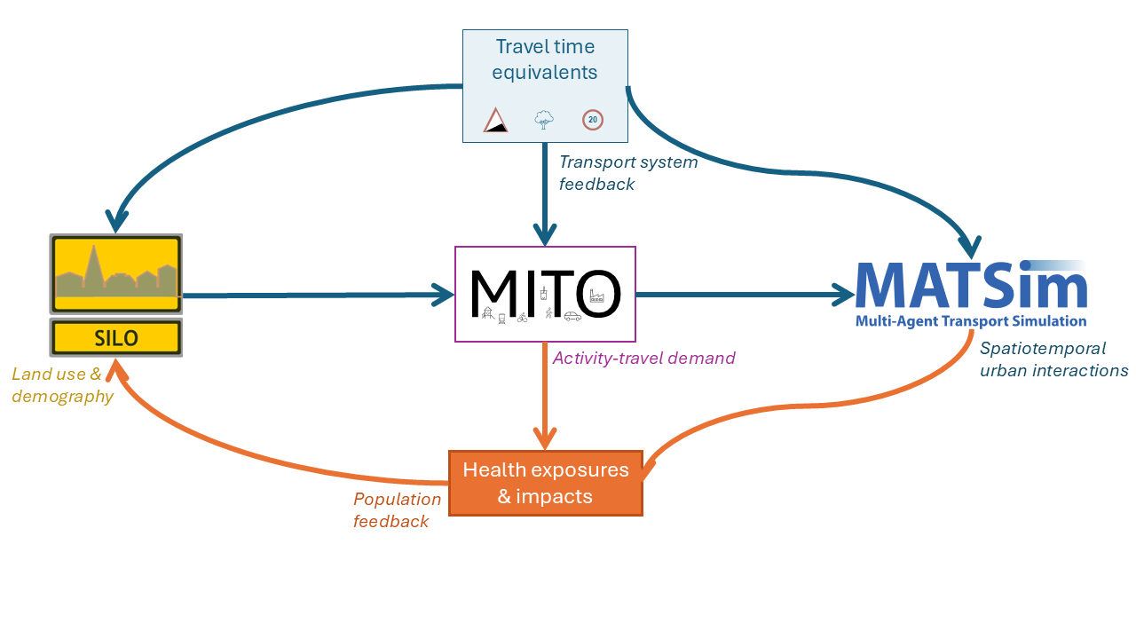
We then use MATSim to simulate travel along that network across a full week, and use the resulting trajectories to estimate person-centric exposure to PM₂.₅, NO₂, noise, green space, traffic injury risk and physical activity. A health impact model takes those exposures, behaviours and demographics and simulates the risk of developing disease and of dying. Code is in the public-health-modelling-Cambridge GitHub organisation and the JIBE project.
In the DARe Hub, we are extending the suite to represent how behaviour adapts to extremes of heat and rainfall — modelling both the disruption that flooding causes to the system and the protective effects of nature-based solutions.
ITHIM: rapid, global health impact assessment of transport
The Integrated Transport and Health Impact Model uses quasi-microsimulation comparative risk assessment to evaluate the health impacts of changes in travel behaviour, through air pollution, traffic injuries and physical activity [3]. It includes Monte Carlo simulation, with code available for value-of-information analysis [4].
The current implementation is open source in R. ITHIM was developed in Cambridge, with further versions built in California; a 2023 systematic review identified ITHIM as the most widely used named model for quantitative health impact assessment of transport [5].
We are now developing a streamlined version that requires far less input data, generating week-long synthetic travel survey data from a mix of sources and sub-models (travelBehaviour repo). It currently covers air pollution and physical activity, with traffic injuries to follow. The aim is to make rigorous transport-health impact assessment feasible for any city, anywhere in the world — not only those with rich travel survey data.
ITHIM Global 2 - proposed workflow
A streamlined transport health impact assessment that needs far less input data
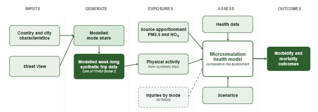
Open source in R - Monte Carlo simulation - stratifiable by age, sex, area, deprivation
Where this is heading
Three directions matter most to us right now.
Climate-cost trade-offs. Health, household budgets and carbon are rarely modelled together, but households experience them together. A shock in the energy system propagates through transport, food, housing and employment all at once — and the cost is rarely shared equally. We are building modelling frameworks that treat this as a single problem.
Beyond transport. Activity-based modelling is fundamentally a model of how people spend a day. That makes it a natural tool for questions about housing tenure, gig-economy working patterns, time poverty and diet — questions where the absence of a person-day-level representation is a serious limitation of current evidence.
Scaling up. Detailed agent-based models are powerful but expensive to build. Streamlined ITHIM and synthetic-population pipelines aim to make the same kind of analysis routine — for many cities, many policies, and at speed. We are particularly keen to expand work in the UK Midlands and to build deeper case studies in cities such as Singapore through the HD4 Programme and Bogotá.
We are building capacity at Loughborough with initial appointments of a senior research position and a PhD student. We will also be working closely with partners at TU Munich, TU Graz, ISGlobal, and my former colleagues at Cambridge. Policy wise we have good collaborations with Active Travel England, Transport for Greater Manchester, DfT and C40 Cities.
If you are a researcher, policy partner, city authority or potential PhD student working on transport, health, climate adaptation, housing, employment, food systems or inequalities — and you think the methods on this page might fit — please get in touch.
References
[1] Staves C, Zhang Q, Moeckel R, Woodcock J. Integrating health effects within an agent-based land use and transport model. Journal of Transport & Health. 2023;33:101707. https://doi.org/10.1016/j.jth.2023.101707
[2] Staves C, Itova I, Zapata-Diomedi B, de Nazelle A, Panter J, Gunn L, Both A, Li Y, Saadi I, Woodcock J, Labib SM. Modelling active travel accessibility at the micro-scale using multi-source built environment data. Computers, Environment and Urban Systems. 2025;119:102270. https://doi.org/10.1016/j.compenvurbsys.2025.102270
[3] Khreis H, Abbas A, Gil-Sanchez D, Tatah L, Schroeder A, Goel R, Brand C, Johnson R, Woodcock J. Description, Development and Application of the Integrated Transport and Health Impact Modelling Tool for Global Cities (ITHIM-Global). medRxiv [preprint]. 2024. https://doi.org/10.1101/2024.12.11.24318676
[4] Schroeder A, Tatah L, Abbas A, Johnson R, Khreis H, Jackson C, Woodcock J. Uncertainty and Value of Information Analysis in the Integrated Transport and Health Impact Modelling Tool for Global Cities (ITHIM-Global). Journal of Transport and Health (in press). medRxiv [preprint]. 2025. https://doi.org/10.1101/2025.08.15.25333754
[5] Mizdrak A, Tatah L, Mueller N, Shaw C, Woodcock J. Assessing the health impacts of changes in active transport: An updated systematic review. Journal of Transport & Health. 2023;33:101661. https://doi.org/10.1016/j.jth.2023.101661
Software and code
- SILO–MITO–MATSim, Public Health Modelling Cambridge: https://github.com/Public-Health-Modelling-Cambridge/silo
- JIBE project: https://github.com/jibeproject
- MATSim core: https://www.matsim.org/
- travelBehaviour (streamlined ITHIM data pipeline): https://github.com/Public-Health-Modelling-Cambridge/travelBehaviour
- ithim https://github.com/ITHIM/ITHIM-R