|
New Atlases: Developing Visualizations to Better Understand Peter Taylor’s concept of World City Networks
(Jared Lang working with Danny Dorling, Bethan Thomas and Peter Taylor)
Introduction
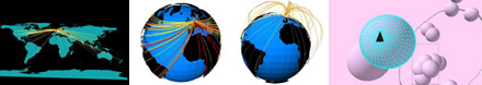
Visualizations have already been developed to compliment Peter Taylor’s World City Networks, but many them are hand-made drawings and diagrams. Depicting world city linkages is a complicated task. Consequently, this project was undertaken to expand upon Peter Taylor’s already existing visualizations using Geographic Information Systems.
When the project began, the research group came up with multiple ideas about how to show connections between cities. The task for the next four months was to implement these ideas. The result was five new Atlases of City Network Connection.
The five full Atlas can be viewed from the hyperlinks below - full screen shots, 3D visualizations, and detailed explanations.
Atlases - still under construction but examples can be viewed
Atlas 1 – Basic Atlas: Wrapping Flat Flow Lines Around a Three-Dimensional Globe
Atlas 1a – Experimental Atlas: Representing Flow Lines in Three-Dimensions
Atlas 2 – City Views: Regional Compacting
Atlas 2a – Experimental Atlas: The “Out of This World” Atlas
Atlas 3 – EarthWise: A New Landscape of Globalization
If you have any questions about the Atlases, or if you want to obtain the details about how the visualizations were created, you can e-mail Jared Lang, Danny Dorling, or Peter Taylor.
|
