GaWC Research Bulletin 267 |
|
|
|
This Research Bulletin has been published in City and Community, 10 (1), (2011), 49-75.
doi:10.1111/j.1540-6040.2010.01340.x Please refer to the published version when quoting the paper.
The notion of an urban hierarchy has long been part of the theoretical toolkit of urban sociologists, geographers, and economists. In some cases, the hierarchy is little more than a ranking of cities used to demonstrate the regularity of population distributions (e.g. Zipf 1941), while in other cases it is used to explain functional differentiation (e.g. Duncan et al. 1960) or integration into the web of globalization (e.g. Alderson and Beckfield 2004). The rankings invoked in such cases often enjoy significant face validity, placing highly visible and obviously dominant places at the top; there is the traditional American triumvirate of New York, Chicago and Los Angeles (Abu-Lughod 1999), while London and Tokyo are invariably included in global hierarchies (Sassen 1991). However, the urban features used to empirically situate cities within such hierarchies have varied widely across studies and often do not mirror theoretical underpinnings, leading to ambiguity about the basis of cities' status in urban hierarchies. This paper seeks to resolve this ambiguity by addressing the hypothesis that the urban features structuring the US urban hierarchy changed during the twentieth century. At the beginning of the twentieth century, many urban economies in the US depended primarily on factors located within the city and its adjacent hinterland, thus situating cities in a size-based hierarchy like that described by central place theory. However, by the end of the twentieth century, technological innovations and economic restructuring led urban economies to depend more on factors located between cities, namely, the relationships among cities that permit the exchange of key resources and allow the development of interurban cooperation and economies of scale. This transition implies the emergence of a newer, more network-based hierarchy in which the dominant cities at the top of the hierarchy are those which serve as 'basing points' for resources flowing through intercity networks (Friedmann 1986). Claims that urban networks and relations of interdependence structure urban systems (McKenzie 1933) and shed new light on central place systems are certainly not new (Vance 1970), and others have hypothesized just such a transition. Rimmer (1998), for example, has argued that population is a misleading guide to identifying and determining the prospects and status of cities. Attention has to shift from population to focusing on the accessibility of key nodes in networks and on the degree of interactivity between them (p. 466; c.f. Pumain 1992, Camagni 1993, Meijers 2007). However, while many have theorized the importance of urban networks, relatively few have directly examined their influence. Thus, this analysis closes a significant evidential gap in the literature by examining the influence of both size-based and network-based urban hierarchies during a sufficiently wide timeframe the entire twentieth century to make this hypothesized transition visible. This paper is organized in five sections. The first section reviews prior theoretical and empirical work on urban hierarchies, highlighting the longstanding theoretical role that urban networks have played, but noting that the empirical incorporation of these ideas has been more gradual. The second section considers how a transition from a size-based hierarchy to one rooted in networks has manifested itself in the hierarchical trajectories of three urban types: the primate city, the offline metropolis and the wired town. The third section describes the use of data on airline passenger traffic and industrial employment data from the Integrated Public Use Microdata Series (IPUMS) to measure the hierarchical status of 64 US metropolitan areas in each decade from 1900 2000. The fourth section presents the results from a series of regression models designed to test the changing influence of size- and network-based urban hierarchies. Findings support the hypothesis that the factors underlying the structure of the US urban hierarchy have changed, while further exploratory analyses suggest that such changes may proceed in waves. The paper concludes with a discussion of the consequences of adopting an air traffic-based picture of the urban network, the actual extent of the observed transition, and the potential for sector-specific effects. APPROACHES TO THE CONCEPT OF URBAN HIERARCHYVariations on central place models (e.g. Christaller 1933, Lösch 1954) have dominated research on functional urban hierarchies, where position in the hierarchy is associated with a city's economic functions within the urban system. Such models begin with the assumption that a city exists to provide goods and services for a surrounding tributary area within which it is located at the center, thus serving as a 'central place' for commerce. Paralleling Smith's ([1776] 2000) claim that the division of labor is limited by the extent of the market, the size of a city's tributary area determines the complexity of goods and services the city provides. Cities with large tributary areas offer the widest range of goods and services, from those satisfying the routine needs of nearby residents (e.g. groceries, personal banking) to specialized products (e.g. designer fashion, investment banking) for which there is more limited demand and consumers are willing to travel greater distances. In contrast, cities with smaller tributary areas offer a more limited range of products to a smaller consumer base within a smaller geographic territory. The extensiveness of a city's tributary area depends on its location relative to other cities along transportation routes that facilitate the movement and aggregation of consumers and goods. Thus, urban functions are organized hierarchically by cities' centrality or importance within a region. Although in theory central place models recognized the importance of urban networks and interdependence, in practice few studies directly examined such relational factors (e.g. Garrison 1960), focusing instead on population size as a proxy indicator of centrality. That is, in many empirical investigations of central place hierarchies, larger cities were assumed to have larger tributary areas, and were found to offer more complex goods and services (Berry and Garrison 1958a). Thus, while central place models it their purest theoretical form hypothesized a network-based urban hierarchy, the majority of empirical applications hypothesized instead a size-based urban hierarchy (Preston 1971). Adopting this stylized form of central place theory, marketers (e.g. Reilly 1929), geographers (e.g. Berry and Garrison 1958b) and sociologists (e.g. Schettler 1943) amassed a large body of evidence suggesting that urban functions were organized according to a size-based urban hierarchy. Although this size-based conception of the urban hierarchy has received extensive attention and empirical support (see Berry and Pred 1965, Mulligan 1984 for reviews), it has also been critiqued for ignoring the role of networks highlighted by earlier forms of central place theory. Indeed, even Christaller recognized that indicators of intercity networks of exchange (e.g. telephones) should be preferred to attributes like population size as measures of central place status (Ullman 1941). Urban ecology represented one of the earliest returns to an explicitly relational approach to urban hierarchies. By viewing cities as having complex relationships of interdependence with one another, much like living organisms, it sought to move beyond simple top-down relations of central place to hinterland where large cities dominate small ones. As McKenzie formulated the metropolitan dominance perspective, mirroring the central hypothesis of this paper, centers and routes are gaining precedence over boundaries and political areas as points of interest in spatial distribution, (1927:28). He pointed to technological innovations in transportation as the catalyst, and to a principle of competitive exclusion as the causal mechanism underlying this shift, noting that the general contraction of space, the increasing fluidity of products and people have the effect of intensifying intercity competition and [therefore] of bringing about various forms of intercity and interregional division of labor (1933:158). These ideas were refined and empirically tested by Duncan and colleagues, who found an urban division of labor wherein occupations (e.g. Duncan and Reiss 1956) and industries (e.g. Duncan et al. 1960) were sorted among cities based on their larger roles in an interdependent urban system: integration and coordination versus production and extraction. Notably, however, although McKenzie's and Duncan's conceptions of urban hierarchy explicitly drew on notions of interdependence and urban networks, empirical investigations tended to rely on non-network indicators like population size (Duncan and Reiss 1956, Duncan et al. 1960, Winsborough 1959, 1960). Thus, as with central place models, although in theory interurban relationships were recognized as critical, in practice they did not appear in empirical accounts of the urban hierarchy. From a slightly different angle, the size-based conception of urban hierarchy was also critiqued by Vance (1970), who saw the central place model as useful only for closed, self- sufficient (i.e. endogenic) urban systems like those that emerged under feudalism. When advances in transportation technology facilitate the spatial separation of production and consumption activities, commerce in the form of wholesaling arises, which he argued cannot be explained by a purely spatial model. That is, while a size-based urban hierarchy may be able to explain where the farmer goes in his Saturday marketing, it cannot account for the destination of his hogs (Vance 1970:162). To solve this deficiency, he proposed a mercantile model wherein dominant cities (i.e. those at the top of the hierarchy) emerge along natural and built transportation routes and derive their economic functions from the long-distance, inter-regional trading relationships these routes facilitate. Within this network of trade and transportation, subordinate cities then fill in the gaps following a central place-like pattern, with their economic functions derived from intra-regional exchange with the more dominant hubs. Empirical work has provided support for these ideas, demonstrating that since the late eighteenth century major US cities have been integrated into an urban hierarchy structured by networks of information (Pred 1973), transportation (Conzen 1975a), capital (Conzen 1975b), and bank correspondents (Conzen 1977). Despite minor theoretical differences in the metropolitan dominance (McKenzie 1927, 1933) and mercantile (Vance 1970) perspectives, both agree that size-based central place models offer an incomplete understanding of how cities acquire their unique economic roles. While a size-based urban hierarchy may explain the distribution of some urban functions (e.g. retail goods and services), it says little about the distribution of other urban functions (e.g. trade or finance) that depend on long-distance interaction. Thus, their critique of central place theory does not propose the replacement of a size-based urban hierarchy with a network-based one, but rather the simultaneous operation, with each organizing different domains of urban economic activity. However, while size- and network-based urban hierarchies may both structure urban activity, as urban economies come to be disproportionately characterized by such activities as trade and finance, the network-based urban hierarchy may nonetheless hold greater explanatory power. Thus, these theories suggest a shift from size- to network-based hierarchy for key cities on major transportation routes (e.g. New York on the Atlantic ocean, New Orleans on the Mississippi river, Chicago on the railroad) as early as the 1790s, but for the majority of the U.S. urban system in the early twentieth century. Although others have empirically examined these revisions to central place theory, because they focused on major U.S. cities in the pre-twentieth century (Pred 1973, Conzen 1975a, 1975b, 1977) or conflated population size with status in a network-based hierarchy (Duncan and Reiss 1959, Duncan et al. 1960), ambiguity about such a transition remains. Although the advances in transportation and communication technology identified by metropolitan dominance and mercantile theories as responsible for a transformation of the US urban hierarchy continue, a more recent series of economic changes have spurred new waves of research that also suggest an emerging network-based urban hierarchy. The development of a 'new economy', spurred by the growing importance of financial capital (Sassen 1991) and a shift toward distance-independent activities like business services (Esparza and Krmenec 1994), has further diminished the role of space and location in structuring the urban hierarchy and defining cities' economic roles, and increasingly focused researchers' attention on urban networks. As a result, a more explicit use of intercity networks emerged in explanations of the functional urban hierarchy's contours. For example, Lincoln (1978) and Ross (1987) found that US cities' centrality in a command and control network of headquarters-subsidiary linkages predicted the presence of higher-order functions, while others found relationships between urban functional differentiation and US cities' positions in networks of trade (Eberstein and Frisbie 1982, Eberstein and Galle 1984), banking (Meyer 1984), information diffusion (Wheeler and Mitchelson 1989, Mitchelson and Wheeler 1994), and transportation (Irwin and Kasarda 1991, Ivy, Fik, and Malecki 1995, Neal 2010). The burgeoning field of globalization and world cities research further extended support for a network-based urban hierarchy under conditions of internationalizing markets. Friedmann and Wolff (1982) defined world cities as those places at the apex of an urban hierarchy of influence whose determining characteristic is not their size of population, as had been the case with the earlier size-based hierarchy, but rather the extent of their integration with the global system of economic relations (P. 310). Similarly, Castells (1996) identified two contrasting ways that social and economic activity is organized: a 'space of places' in which a locale's function derives from characteristics contained within its boundaries, and a 'space of flows' in which a locale's function emerges from its connections to other locales. Drawing on these ideas, much attention has been focused on the hierarchies implied by the world city network, using data on airline traffic (Smith and Timberlake 2001), multinational headquarters and subsidiaries (Alderson and Beckfield 2004), and corporate service firms (Neal 2008). Work in this area is ongoing, but preliminarily suggests the continuing importance of a network-based urban hierarchy into the twenty-first century. Table 1: Theoretical and Empirical Evolution of the Urban Hierarchy.
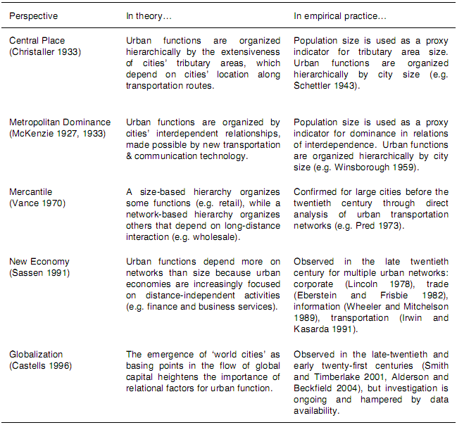
Table 1 summarizes the theoretical and empirical evolution of the urban hierarchy concept. Scanning down the second column, it is clear that the core theoretical propositions of each perspective on urban hierarchy rest on the critical role of urban networks and relations of interdependence. From the earliest central place models to the recent work on world cities, scholars have theorized that cities' positions within an urban hierarchy depend on networks. However, scanning down the third column, it is also clear that these theoretical propositions have not always translated into empirical practice. In the central place and metropolitan dominance models, although the role of networks is highlighted in theory, in practice cities' population size was more often identified as a key factor around which urban hierarchies were organized. More recently, however, studies have offered evidence that directly supports both new and old theorizing about the role of networks. Thus, as Table 1 illustrates, while twentieth century research was characterized by theoretical consistency in conceptions of networks structuring an urban hierarchy, it was also characterized by empirical change in the measurement and evidence for those claims. This pattern suggests that the factors structuring the US urban hierarchy have transitioned. To be sure, this review and the discussion that follows do not describe a dramatic epochal shift from one urban hierarchy to another, but rather a gradual evolution in the way scholars have thought about and measured the factors that underlie urban hierarchies since the beginning of the twentieth century. The following sections trace this evolution in a few specific cities, then in the twentieth century US urban system. HIERARCHICAL TRAJECTORIESTo better understand how this transition has played out, it is useful to consider three potential trajectories (see Table 2). Some large cities have cultivated strong linkages to other cities1, successfully maintaining their position in the urban hierarchy by augmenting their former size-based status with, or transforming it into, network-based status (primate cities). However, other large cities have failed to secure a central position in the urban network and therefore occupy a lower position in the urban hierarchy than their size alone would suggest (offline metropoli). Finally, some small cities that might otherwise have been only peripherally significant in an earlier size-based hierarchy have risen to the top of the hierarchy by virtue of their central network positions (wired towns). Table 2: Hierarchical Trajectories.
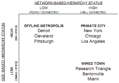
The Primate CityJefferson (1939) first articulated the law of the primate city, noting that the largest city shall be supereminent, and not merely in size, but in national influence (p. 227). These large cities achieved their positions at the apex of the urban hierarchy, for reasons discussed above, by their size within the spatially bounded hinterland surrounding them. However, as the structure of the urban hierarchy came to rely less on spatial factors, and the sheer size of a city could not alone qualify it as supereminent, large cities like New York and Chicago continued to dominate. Such places retained their status because they successfully expanded or transferred the basis of their status in the urban system, thereby transforming from central places within their own adjacent hinterlands into hubs at the intersection networks that link widely dispersed and discontinuous hinterlands. To be sure, a successful transition from size- to network-based status was nearly inevitable for some large cities because they had, for centuries, already maintained extra- regional networks (e.g. New York with London and Amsterdam; Vance 1970, Pred 1973, Abu- Lughod 1999). The case of Chicago is, perhaps, a more vivid illustration of the primate city trajectory because its economy through the early twentieth century was intimately tied to its surrounding hinterlands. Fort Dearborn, the city's pre-incorporation forerunner, anchored the area as a central place for frontier trappers and Astor's American Fur Company. As attention shifted from trapping to farming, the city retained its regional dominance in the mid-nineteenth century by emerging as a new kind of central place a 'porkopolis' for the midwestern livestock trade. Indeed, even the city's pioneering innovations in the finance sector were closely tied to the region, with the establishment of the world's first futures exchange the Chicago Board of Trade in 1848 standardizing and institutionalizing Chicago's traditional central place functions as an agricultural market. Although these early urban functions involved interactions over several hundred miles in some cases, they nonetheless occurred within a geographically adjacent and spatially bounded sphere of influence. As figure 1 illustrates, as recently as the 1930s, Chicago's roles as a transportation, information, and agricultural center were confined to its contiguously bordered hinterland. Figure 1: Boundaries of Chicago’s Spatial Centrality.
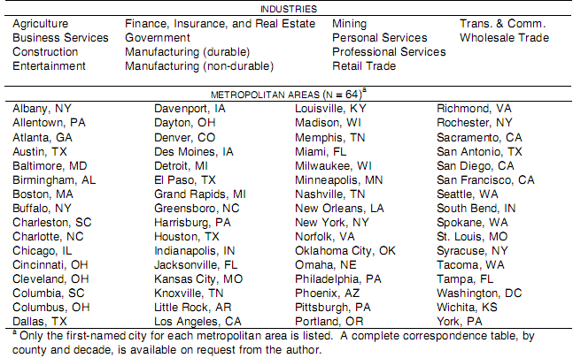
However, Chicago's size-based status contained within it the seeds of an nascent network-based status. As early as 1848, the city's role as a transportation hub was secured by the opening of both the Galena-Chicago Union Railroad and the Illinois-Michigan canal. By linking two existing networks to a new third network the Mississippi river and the Great Lakes to the railroad Chicago's network-based status surged and allowed it to surpass St. Louis in an increasingly network-based urban hierarchy (Cronon 1992). In the decades that followed, its centrality within the urban network and consequent high-order functions were reinforced by the development of trucking and airline routes (Mayer 1954), but its status in the network-based functional urban hierarchy has been supported by non-transportation sources of network-based status as well. Its early market for hinterland agricultural commodities has grown into the world's largest futures and options market, the Chicago Mercantile Exchange or 'Merc', with traders and commodities located globally. Similarly, Chicago is home to the regional or global headquarters of numerous corporate service firms responsible for facilitating exchanges between multinational corporations (Taylor and Catalano 2000). And, since its first sister city agreement with Warsaw in 1960, Chicago has established political and cultural relationships with 27 cities worldwide2. It is these spatially independent network connections, not its large population, that have extended the city's reach beyond its initial hinterland, thereby maintaining its status near the top of the urban hierarchy and its functional role as a key node in the domestic and global economy. The Offline MetropolisHowever, not all large cities have translated their size and regional dominance into network-based status. While many large cities continue to serve as regional centers that provide goods and services to a spatially proximate population, a lack of growth in extra-regional connections has left them relationally isolated and near the bottom of a newer network-based urban hierarchy. Moreover, a large population without a correspondingly central position in the network can bring not only economic liabilities but also such infrastructural strains as congestion, crime, and environmental hazards (Short 2004). Examples of the offline metropolis can be found among declining industrial cities like Pittsburgh and Cleveland that once were central places of the traditional sort, but have forged few interurban linkages that reach beyond their adjacent hinterlands. Detroit stands as an exemplar of the failed augmentation of size-based status with network-based status. Through 1970 Detroit was one of America's five largest cities and anchored the manufacturing belt by serving as a focal point for, and coordinator of, industrial activities in the region. During this time it performed the functions characteristic of a central place, including the provision of corporate services for Fortune 500 companies (17 in 1957) and of retail goods through such consumer monoliths as the J. L. Hudson department store, second in size only to Macy's New York flagship. But, because a narrow and spatially embedded manufacturing base fueled its central place status, without diversification into scale- and distance-independent sectors that rely on inter-urban connections, its position within the functional urban hierarchy could not be maintained. Thus, by 1974 its Fortune 500 population fell to 12, while by 2000 it was only the 21st most central city in the network of Global 500 companies (Alderson and Beckfield 2004) and was home to branch offices of fewer than 30 major corporate service firms (Taylor and Catalano 2000). Compared to its more successful geographic neighbor, Chicago, it is also symbolically revealing that Detroit's only active sister city relationship with Toyota City, Japan is tied to its regional, industrial past. In sum, despite a metropolitan population in excess of 5 million, many of the city's former metropolitan functions and its status in a size-based urban hierarchy have evaporated in the absence of a strong network presence. The Wired TownWhile size is clearly not sufficient for attaining a position within the network-based urban hierarchy, neither is it necessary. Recently, smaller towns that would have been insignificant in a size-based hierarchy are emerging as major centers due to their critical positions in the urban network. Capello (2000) summarizes the underlying mechanism, noting that the need for offering an adequate critical mass of supply and demand formerly satisfied by sheer size can be satisfied thanks to good interconnections via the positive externalities that networks offer (p. 1926). The network externalities upon which smaller cities might capitalize may come in a variety of forms, including scale, reach, and position. First, nearby, complementary cities may pool their resources through infrastructure and exchange networks, forming what has been called a 'network city' (Batten 1995) or 'polycentri metropolis' (Hall and Pain 2006). Although the Randstad region in the Netherlands is the prototypical example, the Research Triangle area of North Carolina offers one example of a such a place in the US, jointly anchored by Raleigh and North Carolina State University, Durha and Duke University, and Chapel Hill and University of North Carolina. These urban and institutional units are closely linked to one another not only through their spatial proximity, but because their common roles as centers of innovation and creativity facilitate relations of collaboration and information exchange. Though network-based economies of scale, these linkages allow the region to achieve a functional complexity, and thus a position in the urban hierarchy, beyond what would be possible in isolation. Second, networks can provide smaller cities expanded reach into their hinterlands and beyond. Cities formerly drew supplies of labor and raw materials, and demand for their products, primarily from spatially proximate hinterlands, the extent of which was assumed to vary with their population size. However, as technological advances have spatially decoupled management, production, and consumption functions, the actual location of supply and demand is less constraining and cities' market areas enjoy enhanced opportunities for expansion. As a result, the increased globalization of the world economy is expanding the global control potential of some cities further down the [old] hierarchy (Lyons and Salmon 1995:99). Examples of cities that have benefited from this network-based compression of space include such unlikely places as Bentonville, Arkansas (Kotkin 2003). As home to Wal-Mart, it now sits at the center of a massive domestic and international supply chain network and is a key node in the networks of advanced producer service firms. To be sure, Bentonville owes its network centrality largely to Wal-Mart. However, the fact that multinational corporations can thrive in small towns through the creation of extensive extra-regional networks highlights the role that networks, rather than simply size, have come to play in urban economies. Finally, the network position of one city relative to others can yield positive externalities above and beyond the scale and reach of its linkages. An influential position in the new urban hierarchy can also be secured through location at a crucial network intersection, linking otherwise disconnected parts of the system. Miami, for example, serves as the primary link between North, Central, and South America. In its role brokering and mediating exchanges of human and financial capital, it is accorded more influence over the flow of resources in the US urban system than other similarly sized cities (Brown, Catalano, and Taylor 2002). Notably, in the case of Miami, while these economic relationships provide a foundation for its status in the functional urban hierarchy, they also induce cultural and immigration flows that support the city's vitality and authenticity, which in turn generate new and stronger economic linkages. METHODOLOGYThe trajectories discussed above illustrate the transition from an urban system functionally organized around a size-based hierarchy to one organized increasingly around a network-based hierarchy. Together with the theoretical literature reviewed above, they also inform two related hypotheses. First and most generally, because a city's position in the urban hierarchy is assumed to influence its economic functions, it is hypothesized that in any given decade, the difference in two cities' positions in the urban hierarchy is positively associated with the dissimilarity of their economies (H1). That is, cities with similar ranks in the urban hierarchy are expected to have similar economies, while cities with different ranks in the urban hierarchy are expected to have dissimilar economies. Second, because a collection of technological and economic changes have altered the basis of cities' status in the urban hierarchy, it is hypothesized that a size-based urban hierarchy had a greater influence over cities' economies during the early twentieth century, while a network-based hierarchy had a greater influence in the late twentieth century (H2). SampleThe analyses below evaluate these hypotheses within a sample of 64 US metropolitan areas (see table 3). This sample includes all metropolitan areas for which the measures described below were available in the Integrated Public Use Microdata Series (IPUMS) throughout the time period under consideration (Ruggles et al. 2004)3. The exclusion of a metropolitan area occurred when either (a) it did not meet size thresholds established by the census to protect confidentiality until the late twentieth century (e.g. Las Vegas, NV), or (b) more than 30% of its population could not be identified because the boundaries of the county-based metropolitan area used to collect census data do not coincide with those of the public use microdata areas (PUMAs) used to report microdata (e.g. Providence, RI)4. Despite these necessary omissions and the challenges associated with a 100 year study period, the sample is inclusive, capturing an increasing proportion of the total US population (26% in 1900, 53% in 2000) and approximately 70% of the urban US population in all decades. Table 3: Included Industries and Metropolitan Areas.
For each decade between 1950 and 2000, the unit of observation is the metropolitan area as defined by the U.S. Census Bureau in that year. Because the U.S. Census Bureau did not define metropolitan areas before 1950, for each decade between 1900 and 1940, the unit of observation is the metropolitan area defined by the (IPUMS) variable METAREA, which retroactively applies rules similar to those used by the Census in 1950. In those decades before an urban settlement was recognized as a metropolitan area, the central city alone is used as the unit of observation. This approach recognizes that metropolitan area boundaries change over time, and treats these changes as reflecting real changes in the organization of the metropolis that cannot be ignored. Thus, these units of observation aim for social and economic, but not geographic, consistency. MeasurementFollowing the majority of research on central place systems, position in the size-based urban hierarchy is defined using rank by population size (Berry and Pred 1965, Mulligan 1984). Notably, Christaller, the father of central place theory, argued that population alone is not a true measure of the central importance of a city (Ullman 1941:858). However, in a review of the central place literature, Berry and Pred (1965) found that for studies of urban systems on every populated continent, as the populations of central places increase, so do the numbers and types of business establishments they possess, the sizes of their trade areas and dependent populations, and the distances they are separated from centers of similar size (p. 6). Thus, while population size may not be a direct measure of centrality within a tributary area, it has consistently been used as a proxy indicator. Because hypothesis H1 is framed in terms of differences between pairs of cities, the concept of position in the size-based hierarchy must be defined as the dyad level. Therefore, the 'difference in two cities' positions in the size-based urban hierarchy' (SIZE) in a given decade is operationalized as the difference in their rank by population size. Measuring position in the network-based hierarchy is more difficult because there are many types of inter-urban relationships and data on each is limited (Short et al. 1996). Prior studies have relied on the interstate highway system (Garrison 1960), bank correspondent linkages (Conzen 1977), trade flows (Eberstein and Galle 1984), or headquarter-subsidiary locations (Ross 1987) to define economic networks among cities. While these approaches provide valuable windows into the urban network, they are not practically viable when examining cities over the wide timeframe required by these hypotheses. Instead, air passenger movements are used to indirectly measure flows of economic resources and decision-making power. Taaffe (1956, 1962) pioneered this approach, using data on airline traffic to define a new urban hierarchy, which he found to be associated with city function. Others have continued in this vein, arguing that airline linkages are ideal for measuring city connectivity because great demand still exists for face-to-face relationships, despite the global telecommunications revolution, [and] air transport is the preferred mode of inter-city movement for the transnational capitalist class, migrants, tourists, and high-value, low-bulk goods (Keeling 1995:118; Irwin and Kasarda 1991, Ivy, Fik, and Malecki 1995, Smith and Timberlake 2001). Therefore, the 'difference in two cities' positions in the network-based urban hierarchy' (NETWORK) in a given decade is operationalized as the difference in their rank by network centrality. The urban network is defined by intercity airline passenger traffic in each decade after 1930 (U.S. Department of Transportation 2001, 1991, 1981, 1972; Civil Aeronautics Board 1951, 1941). Each city's centrality within this network is defined by their total number of in- and out-flows (i.e. degree centrality, Freeman 1978/79). Measuring a city's economy is also challenging because it is characterized by a number
of unique dimensions (e.g. manufacturing, services, etc.). However, framing hypothesis H1 in
comparative terms offers a solution. Rather than requiring a multifaceted measure of each city's
economy, testing this hypothesis requires only a single measure of the dissimilarity of two cities'
economies. Here, the 'dissimilarity of two cities' economies' (ECONOMY) in a given decade is
operationalized as the Euclidean distance between two cities (a and b), with respect to the
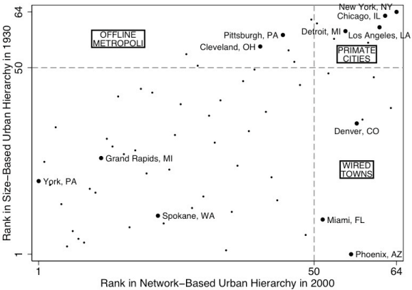
employment in each of 14 major industry categories (i) listed in table 3: The vector of data capturing employment in each of the 14 major industries (EMPLOY1, EMPLOY2, EMPLOY14) was obtained by first recoding individuals' reported industry of employment from each decennial census into the US Census Bureau's 1950 classification system5. These individual-level data were then aggregated, for each decade, by metropolitan area and major industry. Finally, the resulting counts were divided by total employment and standardized as z- scores. By incorporating employment in multiple industries, this dissimilarity-based operationalization captures the multifaceted nature of cities' economies in a single dependent ariable. While the absolute magnitudes of ECONOMY are difficult to directly interpret, the meaning of their relative magnitudes is clear. For example, because Cleveland and Milwaukee have similar economies, the value for this pair is small (1.422 in 2000), while because Cleveland's economy is very different from that of Washington, DC, the value for this pair is large (7.652 in 2000). Because ECONOMY includes an observation for every pairwise combination of cities in the sample, through a form of triangulation, it precisely captures the characteristics of each individual city's economy (Tsogo, Masson, and Bardot 2001). This dissimilarity-based approach to defining urban economic structures follows the approach developed by Duncan et al. (1960) to consider the question of how to recognize a tendency toward 'hierarchy' (p. 61)6. Several issues can arise when examining employment data over time and space, but are not believed to affect the analyses below. First, changes in the nature of specific industries and their classification over the twentieth century complicate longitudinal analyses. However, in recoding employment data from different decades into a common classification system, every effort was made to yield longitudinally comparable industrial categories (Ruggles et al. 2004). Additionally, because analyses involving the variable ECONOMY are cross-sectional (see equations (2) and (3) below), industrial employment data from different decades are not analyzed together. Second, the uneven spatial distribution of the components of major industry groupings can complicate multi-city analyses using highly aggregated data. However, the processes under investigation (i.e. the hierarchical sorting of economic activities among cities) are hypothesized to influence the distribution of major industrial activities, but not necessarily their components. For example, while the theories discussed above suggest that a city at the top of the urban hierarchy should employ a large share of individuals in the 'business services' industry, they say nothing about whether that employment should be in accounting or advertising. RESULTSTo empirically examine the three urban archetypes described above the primate city, offline metropolis, and wired town figure 2 plots each city's rank in the size-based urban hierarchy in 1930 and in the network-based urban hierarchy in 2000. To contextualize these results without rendering the plot unreadable, only selected cities are labeled: all cities in the sample that are identified as exemplars in table 2, as well as five additional cities (Denver, Grand Rapids, Phoenix, Spokane, and York). The dashed lines divide the space into quadrants corresponding to those in table 2. Cities above the horizontal dashed line are the 15 most populous cities in 1900, occupying top positions in the early size-based urban hierarchy. Similarly, cities right of the vertical dashed line are the 15 most connected cities in 2000, occupying top positions in the emerging network-based urban hierarchy. Figure 2. Observed Hierarchical Trajectories.
Most cities in this sample occupy lower positions in both hierarchies (i.e. the un-named lower left quadrant) and have played only minor roles in coordinating the urban system (e.g. York, PA; Grand Rapids, MI; Spokane, WA). However, clear groupings among some cities are apparent. Primate cities like New York, Chicago, and Los Angeles were large and influential early in the twentieth century, but continue to be influential through their connectivity. Offline metropoli like Pittsburg and Cleveland, while initially large and influential as industrial centers, have not maintained equally high positions in the newer network-based hierarchy. Instead, their positions of influence have been assumed by such smaller but better-connected wired towns like Miami, as well as young cities that have experienced explosive growth in their interurban connections (e.g. Denver, Phoenix). While primarily descriptive, this plot generally supports the face validity of the hierarchical trajectories and corresponding urban archetypes articulated in table 2 and the associated discussion above. Notably, although Detroit is characterized above as an offline metropolis, it appears here in the quadrant corresponding to the primate city type. This (mis-)classification is likely driven by the use of an airline traffic network to define cities' status in the network-based hierarchy. As one of Delta Airlines' hubs, Detroit's network-based status is artificially inflated due to the large volume of connecting passengers. This apparent centrality is driven by largely by spatial factors like the city's convenient location in the middle of the country, but does not indicate the presence of extra-regional ties because such connecting passengers are in Detroit (or rather, it's outskirts) for only an hour or so and contribute little if anything to the city itself. This potential source of bias when using airline traffic data is considered below in the discussion section and has been examined in greater detail by Neal (2010). Turning to the two hypotheses offered in the previous section, what effect does a city's position in these two hierarchies have on its economic structure, and has this effect changed over the past century' Notably, these hypotheses are nested: H1 posits that in a given decade ECONOMY is related to SIZE and NETWORK, while H2 posits that the strength of the relationships described by H1 vary over time. Therefore, the procedure used to evaluate these hypotheses follows a similarly nested design like that described by Blau and Alba (1982)7. To test hypothesis H1, the following ordinary least squares (OLS) regression model is estimated, separately for each decade from 1900 through 2000:
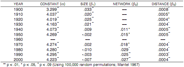
That is, cities' economies are a function of their position in the size-based hierarchy (in all decades) and network-based hierarchy (since 1940). The straight-line distance (in miles) between each pair of cities is included to control for the likely influence of cities' proximity on their economies, sizes, and air traffic levels. Because dyadic (i.e. city pair) observations are not independent, statistical significance is assessed using Mantel's (1967) non-parametric approach with 100,000 permutations. Despite an expectedly close association between SIZE and NETWORK (e.g. r = .79 in 1990), because the variance inflation factors (1.22 in 1940 3.23 in 2000) do not exceed ten (Gujarati 2003) and because the non-parametric approach does not rely on standard errors to judge statistical significance, multicollinearity is not believed to be a problem. The estimates for each decade's regression are displayed in Table 4. All significant and nearly significant estimates are positive, providing support for hypothesis H1, that differences in two cities' positions within an urban hierarchy are associated with dissimilarities in their economies. Table 4: Estimates of Regressions Predicting Dissimilarity of Cities' Economies, by Decade.
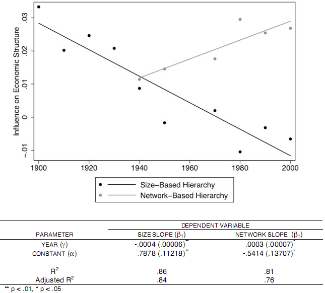
To test hypothesis H2, two OLS regression models that treat the slopes in equations (2) and (3) as functions of time are estimated:
The results, displayed in figure 3, demonstrate that over the twentieth century the strength of the size-based hierarchy's influence on cities' economies significantly declined (?1 = -.0004, p < .01), while at the same time the strength of the network-based hierarchy's influence significantly increased (?1 = .0003, p < .05). The intersection of these two regression lines provides support for H2, that a transition in the organization of the US urban hierarchy occurred during the twentieth century. More specifically, while the US urban system was once organized around a size-based hierarchy, it is now increasingly organized around a network-based hierarchy. Figure 3: Linear Model of Hierarchical Transition.
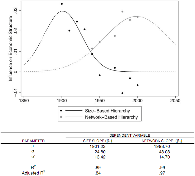
Waves of Hierarchical Transition?The evidence of a transition from a size- to a network-based urban hierarchy is strong, but a purely linear model of this transition is theoretically problematic. First, such a model suggests that the size-based hierarchy once had, or that the network-based hierarchy will eventually have, a near-infinite influence over cities' economies. Instead, it is more likely that specific forms of urban hierarchy grow, peak, then decline in influence. Second, it suggests that as earlier forms of the urban hierarchy decline in influence, they acquire a negative influence (e.g. the size-based hierarchy in figure 3 after about 1970), which would imply that cities with different positions in the hierarchy have similar economies. Instead, it is more likely that obsolete forms of hierarchy simply decline into statistical non-significance. Together, these modifications suggest that a more reasonable model of this transition ought to be curvilinear (Berry 1991, Batten and Thord 1995). To explore this possibility, equations (4) and (5) are re-estimated using STATA's non- linear least squares command to predict each slope (ß1 and ß2) as a non-linear function of time:
This function fits the data to a bell-shaped curve. Figure 4 presents the coefficient estimates and illustrates the curvilinear pattern of predicted slopes (i.e. level of influence of the two hierarchies on cities' economies) during the twentieth century; dashed lines illustrating predictions for the preceding and following fifty years are included to highlight the curve's basic shape. Because the model's complexity and small sample sizes do not allow reliable estimates of standard errors or the assessment of the coefficients' statistical significance, these values are not presented. However, for reasons discussed above, this functional form is more theoretically motivated than a simple linear model. Moreover, comparison of the non-linear model's adjusted R2 values to those from the linear model indicates that it describes the size-based hierarchy transition equally well (adjusted R2 = .84 (linear model) vs. 84 (non-linear model)) and the network-based hierarchy transition better (adjusted R2 = .76 (linear model) vs. .97 (non-linear model)). Figure 4: Nonlinear Model of Hierarchical Transition.
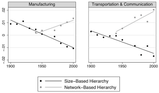
Figure 3 in essence 'zooms in' on the linear portion at the middle of the figure 4. However, the temporally expanded and more theoretically motivated view illustrated in figure 4 may offer some, albeit heuristic, insights into the potential catalysts of a hierarchical transition. First, it raises the possibility that a size-based hierarchy may have been less influential before the mid-nineteenth century, at a time when locational (e.g. proximity to a waterway) or political ats of government) factors may have been more important. Second, it locates the size- based hierarchy's peak influence just after the beginning of the twentieth century, which closely corresponds to the selection of Federal Reserve cities on the basis of population size and spatial dominance (Reserve Bank Organization Committee 1914), in essence imposing an institutionalized size-based hierarchy upon the nation's financial system. Third, it suggests that the network-based hierarchy's greatest gains in influence occurred in the last quarter of the century, following the 1978 Airline Deregulation Act, which effectively eliminated a mandated central place-like hub-and-spoke structure and paved the way for a more complete point-to-point network of exchange. Finally, the projected late twentieth century decline of the network-based hierarchy's influence, while partly driven by right-censored data and the peculiarities of equation (6), nonetheless raises interesting questions about the potential for transitions to other forms of urban hierarchy in the future. DiscussionWhile these findings provide evidence of a transition in the basis of cities' status in the urban hierarchy, they also raise several issues. First, using air traffic to define the urban network and measure cities' network-based status is subject to a number of scope limitations, and potentially introduces some unique sources of bias. Second, although these results indicate that a network-based hierarchy is now more influential than a size-based one, they do not necessarily indicate that space is unimportant. Finally, it is possible that these results mask subtler shifts in the influence of different urban hierarchies by aggregating economic sectors rather than analyzing them separately. This section considers each of these issues, offering some directions for future research. Out of Flight, Out of Mind?The use of air traffic patterns to define city connectedness offers the rare possibility of longitudinal research on urban networks, but is also subject to some limitations that call for caution in interpreting these results and highlight the need for additional work in this area. First, this approach is restricted in its geographic scope because it cannot capture the network centrality or network-based status of cities that lack an airport or that are served primarily through other modes of transportation. Thus, the importance of networks for smaller cities and for cities in the rail-dominant Northeast may be underestimated. Similarly, this approach is restricted in its temporal scope because it cannot capture the urban network before 1940. Omitting a measure of the network-based hierarchy before 1940 (see equation (2)) could lead to inflated estimates of the influence of the size-based hierarchy from 1900 through 1930. Indeed, Christaller (1933) and McKenzie (1933) would likely argue that including a network-based hierarchy defined by early water or rail-based urban linkages would reveal that the size-based hierarchy had little economic influence even at the beginning of the twentieth century8. Thus, although the archival data is not as well organized as the early air traffic data, future historical studies would benefit from also considering pre-aviation transportation networks, including the well-developed lake shipping networks of the early 19th century and the rail networks of the mid- and late 19th century. Second, an exclusively air traffic-based measure does not include several other important types of urban connections, including the physical or electronically mediated movement goods and information, or the movement of individuals who cannot afford air travel (e.g. migrant workers). Additionally, although the air traffic data include all passengers, it is impossible to separate business and leisure travel, which follow different patterns and involve distinct types of exchanges (Limtanakool, Schwanen, and Dijst 2007, Neal 2010). As a result, other definitions of network connection may yield slightly different hierarchies in which vacation destinations or immigration hubs, for example, appear more central. Even in these alternate network-based hierarchies, however, urban networks would still be expected to exert a greater influence over cities' economies than hinterland characteristics. For example, however large or small an immigrant-dominated city may be, its economy is likely to be influenced by its position in the wider immigration network. If it serves as a final destination, its economy may be characterized by low-wage jobs, while if it serves as a gateway to interior destinations, its economy may include more administrative and infrastructural activities like passport and transit services. Finally, an urban network based on air traffic may be distorted by external factors including airlines choice of hub locations. The method used to define cities' network-based status likely yields overestimates for hub cities (e.g. Atlanta for Delta, Dallas for American, or Chicago for United), which have high volumes of passenger traffic but are less often passengers' final destination (Neal 2010). However, while the hub-and-spoke organization of airline routes may yield biased estimates of cities' network-based status, such bias does not impact this study's principal conclusions because it only serves to make the above hypothesis tests more conservative. For example, if the economic structures of cities with artificially high network-based status due to their hub roles were indeed systematically different from those of cities with more legitimately high network-based status, the statistically significant findings reported above would be less likely to emerge. The pattern of significance that is detected affirms the strength of the findings, despite the likely influence of airline hub effects. Future studies of the network-based urban hierarchy must look for more inclusive and nuanced ways to capture cities' network connections. First, to account for the long-range ties characteristic of city networks as well as the short-range ties characteristic of network cities, it may be useful to combine multiple modes of transportation that operate at different scales (e.g. planes, trains, and automobiles; see Batten and Thord 1995). Second, using existing airline traffic data in novel ways, it may also be possible to distinguish business from leisure passengers, and destinations from hubs, providing insight into the content and organization of such exchanges (Neal 2010). Finally, it will be important to move beyond the infrastructural and economic measurement of urban networks. Taylor's (2005) examination of cities connectedness within four types of networks - economic, cultural, political, and social is an important first step toward overcoming this myopia. The Death of Space and Birth of Networks?This paper has demonstrated that during the twentieth century the US urban hierarchy transitioned from having a size-based central place-like structure to being relationally structured around urban networks. However, the results presented above should not be interpreted as supporting claims of the death of space at the hands of digitalization and globalization (Morgan 2004). The increasing importance of a network-based urban hierarchy does not rule out the influence of a city's hinterland on its economy. As in the case of the 'network city' (Batten 1995) or 'polycentric metropolis' (Hall and Pain 2006), some places will be more highly connected with their own hinterlands than with exotic international cities, and in such cases spatially proximate territories remain quite important. Conversely, these results also do not herald the birth of an entirely new form of urban economic organization. Indeed, extra-regional connections among cities have played a crucial role in economic development for centuries, with incremental technological advances extending the distances they span and range of cities they link. This interpretation of the transition as significant but not absolute closely follows Castells' (1996) distinction between the somewhat idealized 'spaces of flows,' where function derives from extra-regional ties, and the more familiar 'spaces of places,' where most people live and where function derives from ties within a more-or-less bounded region. More recently, others have suggested a similar contrast, between 'town-ness' as a locally focused process of external urban relations and 'city-ness' as its non-local analogue (Taylor, Hoyler, and Verbruggen 2010). As these dichotomies demonstrate, the spatial factors like size and relational factors like networks operate together to define urban economies and structure the urban system. Thus, while not evidence of a complete transition, these findings hint instead at a subtler shift in the balance of explanatory power, wherein size continues to be relevant but are no longer primary. Notably, however, these findings may also point to a shift understandings of urban growth and prosperity. Urban growth has typically been framed in terms of population, where population loss is an indicator of urban decline. However, as the organizing force of urban economic activity shifts from space and size to network and centrality, the notion of urban growth must also shift. For large cities burdened by infrastructural demands, a decline in population size may actually provide greater flexibility, especially when offset by the forging of new interurban connections. People need not live within a city's boundaries to contribute to its economy; with a robust network of connections to other urban areas, individuals living nearly anywhere can be the basis of a city's economic growth. As a result, the power to steer a city's trajectory may also have shifted. Those urban and business leaders who are in a position to decide where new high-speed transit should go, or with which firms in other cities to establish strategic alliances, may represent a new locus of power over urban growth. Conversely, however, a high degree of network centrality may not automatically translate into power because intercity exchanges are often asymmetric and interacting cities often do not benefit equally. Future research, therefore, should consider the broader political consequences of the observed transition. The Relationship Between Sector and HierarchyThe results above demonstrate that the urban hierarchy with the greatest influence over cities' economic structures has shifted from size-based to one grounded in intercity networks. However, because the notion of 'economic structure' combines several industries into a comprehensive picture of each city's economy, these analyses do not permit conclusions about the size- or network-based hierarchies' influence over specific types of economic activity. For example, while the influence of a size-based urban hierarchy appears to have generally declined over the past century, has its influence over some sectors declined more, or are there certain economic activities over which it actually has an increasing influence? The literature that might inform such hypotheses is mixed. The earliest studies of size- based urban hierarchies focused primarily on goods-related industries (e.g. manufacturing or retail). Indeed, much attention was focused on identifying the 'range' or spatial sphere of influence for very specific types of products like women's hats, which Reilly (1929) found begin to appear in towns of at least 40,000 people (Berry and Garrison 1958a). However, later research adopting a similar size-based measurement found that such hierarchies were also influential in the distribution of more advanced activities including professional occupations (Winsborough 1960). More recent studies of a network-based urban hierarchy have focused primarily on financial services and information industries (Sassen 1991, Castells 1996). However, others working within this network tradition have argued that such network-based hierarchies are also influential for goods-based manufacturing value chains (Smith and Timberlake 1995). Figure 5: Linear Model of Hierarchical Transition, Selected Sectors.
Empirically untangling the relationship between sector and hierarchy is complicated because, as technologies evolve, industrial classifications such as the North American Industrial Classification System (NAICS) change. Figure 5 displays the results of two supplementary analyses that re-estimate equations (2) and (3) using disaggregated versions of ECONOMY that measure employment in individual sectors: a manufacturing-only analysis in the left panel, and a transportation and communication-only analysis in the right panel. These supplementary analyses suggest that the study's primary finding is robust across multiple sectors even when examined individually. As figure 5 illustrates, a hierarchical transition similar to that identified for an aggregate conception of urban economic structure (e.g. figure 3) is also evident in the urban distribution of specific sectors. Although manufacturing is commonly associated with spatially embedded factors (e.g. raw materials, labor), and transportation and communication activities are commonly associated with network infrastructures (e.g. telephone lines, internet cables), the urban distribution of both activities appears to have followed a common hierarchical transition. Specifically, urban economic specializations in both manufacturing and in transportation and communication were organized according to a size-based hierarchy in the early twentieth century, but more recently have followed a network-based hierarchy. To be sure, minor differences in the timing and completeness of the transition are also apparent when looking at different industries. For example, in the early twentieth century the size-based urban hierarchy was less influential for the distribution of transportation and communication activities than for employment in manufacturing. Similarly, the growth of the network-based hierarchy's influence has been more rapid for transportation and communication than for manufacturing. Together, such differences may reflect a relatively intuitive notion that transportation and communication industries are more network dependent than manufacturing. However, despite some sector- specific deviations, these exploratory analyses suggest that the hierarchical transition observed above is not merely an artifact of the aggregate operationalization of economic structure. While largely consistent with expectations, these results must be interpreted cautiously because they depend on the ability to reliably follow specific industrial sectors over long periods of time despite technological and classificatory changes. But, following Wilbur Thompson's claim that a region's industries determine its future, further clarifying the relationship between sector and hierarchy is critical for understanding how urban hierarchies can push cities toward more or less viable activities and toward more or less stable futures. Thus, future research should seek ways to track sectors over time and to consider how urban hierarchies influence different activities in unique ways. CONCLUSIONThis study has sought to demonstrate that the structure of the urban hierarchy is fluid. At the start of the twentieth century, urban economies were organized primarily around a size- based hierarchy. However, with the emergence of new types of goods and services and new ways to move them, the urban hierarchy has increasingly become structured by a network- based hierarchy that reflects cities' centrality within networks of interurban exchanges of people, money, and information. This transition is significant for theoretical reasons because it calls attention to the transitory nature of status in the urban system, and to the need for future work to monitor inevitable changes in how the urban hierarchy is structured. REFERENCESAbu-Lughod, Janet L. 1999. New York, Chicago, Los Angeles: America's Global Cities.
Minneapolis, MN: University of Minnesota Press. NOTES* Zachary P. Neal, Department of Sociology, Michigan State University, 316 Berkey Hall, East Lansing, MI 48824;
zpneal@msu.edu. The author wishes to thank William Bridges, Richard Florida, Jennifer Watling Neal, 1. Any discussion of urban systems risks reifying cities and treating them as actors. The variety of forms that urban networks may take yields an equal variety of actors that constitute and maintain the networks. In intercity transportation and communication networks, individuals (e.g. passengers, callers) are the true actors. In command and control networks like those discussed by Alderson and Beckfield (2004), firms (given agency by executives) are the actors. Finally, in political networks like those forged by sister city relationships, the cities (given agency by political leaders) are the actors. For the sake of simplicity, cities are discussed as the actors responsible for the network, but it is recognized that the actual actor depends on the type of network and the conceptual level of analysis. 2. Whether sister city relationships are relationships of political convenience or reflect more meaningful exchanges is an open question, and one that goes beyond the scope of this paper. However, they at least have symbolic value as highly visible indicators that the city (i.e. its political and business elite) is cognizant of the extra-regional world. 3. Because individual metropolitan areas cannot be identified in the 1960 IPUMS data, this decade is omitted from the study period. 4. In most cases PUMA boundaries were drawn to overlap with county-based metropolitan area boundaries. However, in some cases from 1980 – 2000, a single PUMA included both metropolitan and non-metropolitan counties, such that reporting both a person's PUMA and metropolitan area of residence would allow microdata users to distinguish geographic areas smaller than permitted by confidentiality controls. Thus, for people living in PUMAs that included both metropolitan and non-metropolitan counties, metropolitan area of residence is not included in the data. Further details on IPUMS geography and metropolitan area identification are available at http://usa.ipums.org/usa/volii/incompmetareas.shtml. 5. This recoding was performed by the IPUMS team (Ruggles et al. 2004), and is recorded in the IPUMS variable IND1950. Documentation and correspondence tables are available at http://usa.ipums.org/usa. 6. In their original analysis, Duncan et al. (1960) used this dissimilarity index to determine whether “industry distributions do fall into a hierarchic pattern and if the size classification of cities is accepted as a rough classification by levels in a hierarchy” (p. 61). Limitations of computing power required that they compute and compare the dissimilarity not of specific cities, but rather of groups of similarly sized cities. Even ten years later, applying this method to a entire sample of specific cities was viewed as “a near impossible task” (Duncan and Lieberson 1970:148). This analysis returns to a method of investigating urban hierarchies developed by Duncan, a key urban hierarchy theorist, in the robust way he had originally intended but lacked the computing power to realize. 7. This approach is conceptually parallel to the familiar hierarchical linear models described by Raudenbush and Bryk (2002), but is used here because it allows for the required non-parametric estimation of statistical significance in equations (2) and (3) below. Although Blau and Alba recommend a larger a value when using this approach, the conventional Type-I error level of .05 is used here. 8. Sensitivity analyses indicate that the slope and intercept of the spatial hierarchy's influence from 1940 through 2000, which are unbiased because they control for the influence of the relational hierarchy, are not significantly different from those for the period 1900 1930. Thus, the omission of the relational hierarchy from these models before 1940 does not appear to introduce bias.
Note: This Research Bulletin has been published in City and Community, 10 (1), (2011), 49-75 |
||