GaWC Research Bulletin 78 |
|
|
|
This Research Bulletin has been published in Annals of the Association of American Geographers, 92 (2), (2002), 320-340.
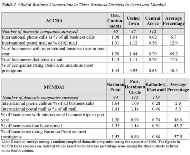
One of the ironies of the academic debate on globalization is its Western bias. Much of the theorizing and empirical research is based on the experiences of the United States, West Europe, and other countries in the core of the world economy. This is also true for most scholarly work on cities and globalization in geography and other social sciences. Overall, the globalization debate is not nearly as "global" as it probably should be. In this article, we explore the changing urban geographies of cities in the less-developed world1 in the context of economic globalization. We argue that the internal spatial structure of such cities can be understood in terms of their evolving roles in the wider-world political economy. Cities differ in the ways they are linked to the external economy. This differentiation is as much a function of the idiosyncratic features of the city as a place and location as it is of developments in the global economy. In this study, we acknowledge the former, but we concentrate on the latter. We conceptualize the broader spatial context of cities in terms of a political economy because (sub)national government policies determine, to a large degree, the exposure of the urban arena to global economic forces. Many cities in the less-developed world have moved through four historical phases: precolonialism, colonialism, nationalism, and globalism. We argue that during each of these phases, urban geographies have changed in relation to the role of the cities in the global political economy. The global era is the most recent phase of restructuring. Our investigation concentrates on two cities: Accra in Ghana and Mumbai in India (in 1995 Bombay was officially changed to Mumbai; we use both names, depending on the historical period). A parallel study of urban change in two different cities in different settings helps to move beyond description and allows some degree of generalization. We selected Mumbai and Accra because of their similar political-economic histories and their geographic disposition as gateway cities.2 We present a more elaborate argument for the choice of the case studies at the end of the theory section of this article. Our analysis focuses on the changing foreign corporate presence in the two cities as one important measure of economic globalization and the effects on the cities' overall corporate geographies.3 The research is based on extensive fieldwork in Accra and Mumbai between 1998 and 2000 and on assembled datasets on foreign and domestic corporations-their year of establishment, main activity, location, size, and so on. We find that there have been profound changes in recent times that were neither random nor accidental. We explain the main trends in Accra and Mumbai in terms of the changing linkages to the global economy since the implementation of liberalization policies. This article concentrates on the comparative dimension of our research and its theoretical implications. The rest of the article consists of six parts. First, we briefly review the existing literature on cities in the less-developed world and globalization. Second, we present the main tenets of our historical theoretical framework. Third, we describe our data and methodology. Fourth, in accordance with our historical approach, we provide a brief overview of Accra and Mumbai during colonial times and since independence. Fifth, we report on the findings of our empirical analysis of the changing economic geographies of Mumbai and Accra in the global era. In the conclusion, we return to our argument about the importance of historical and geographical context to our theoretical understanding of cities in the world today. GLOBALIZATION AND CITIES IN THE LESS-DEVELOPED WORLDThree relevant literatures make explicit or implicit claims about cities in the less-developed world: first, a recent theoretical literature on cities and globalization; second, a more established, empirically oriented tradition of studies of "Third World cities"; and finally, a specialized literature on urban spatial modeling. All of these approaches have developed in relative isolation from each other, and research findings are not integrated. None of the three approaches have thus far been capable of explaining the spatial imprint of globalization in these cities. The most coherent body of theoretical work that focuses on cities in a global context is known as the "world city" literature (e.g., Friedmann and Wolff 1982; Friedmann 1986; Knox and Taylor 1995; Short and Kim 1998; Beaverstock, Smith, and Taylor 2000; Sassen 2000). This literature focuses on the emergence of a global hierarchy of cities that form the basic nodes of the world-economy. The world-city hypothesis also states that a city's local character and its internal economic and social structure reflect the city's particular position and function in the world economy. The first part of this hypothesis led to research on the role of major cities as command and control centers in the world-economy and to classifications of cities around the world in the global urban hierarchy. It is argued that cities have become increasingly important as places from which the world-economy is orchestrated: the city as command or power center, a "basing point," a node in the world-economy. This emphasis on the power position of cities naturally implies a focus on cities in the core regions of the world-economy-especially New York, London, and Tokyo. Another part of the world-city literature addresses the extent to which economic, social, and political relations and processes within cities-that is, at the urban scale-are influenced by forces operating at a global scale. Sassen (2000, 59-60) argues that the globalization of many cities is accompanied by the formation of a "new urban economic core of banking and service activities that comes to replace the older, typically manufacturing-oriented office core." The world city literature is mostly aimed at cities at the top of the urban hierarchy. In the process, cities in the lower strata of the global hierarchy-particularly cities in the less-developed world-are neglected. Hence, the literature often advances claims of universal validity without proper theoretical consideration of and without substantial empirical research in cities in the less-developed world (Nijman 2000a).4 Situated at the other end of the spectrum, the literature on "Third World cities" has a strong empirical orientation. The origins of this literature go as far back as the 1950s, predating the globalization debate and, therefore, predating a theoretical framework linking urban change to economic globalization. At the time, cities and urbanization were regarded mainly in the context of development and underdevelopment. The strength of this approach, especially where case studies are concerned, is in its rich description by scholars with considerable experience in the field (e.g., de Blij 1968; Harris 1978). Armstrong and McGee (1985) and Smith (1996) make a more deliberate effort to link global theory to urban developments in the lesser-developed world. Their research is theoretically anchored in world-systems analysis and reaches back to dependency theory. A world-systems approach can be used to theorize the ways in which cities in the periphery are either generative or parasitic toward their national environment, and/or the mechanisms by which particular sectors of the urban economy become more or less articulated with the global economy (e.g., Simon 1992). Armstrong and McGee use the intriguing term "theatres of accumulation" to describe the role of Third World cities in the global economy. They (41) argue that "Cities are, simply stated, the crucial elements in accumulation at all levels, regional, national, and international, providing both the institutional framework and the locus operandi for transnationals, local oligopoly capital, and the modernizing national state." However, neither Smith (1996) nor Armstrong and McGee provide substantial empirical evidence, and they barely address the question of internal spatial change within cities in relation to global capital. The third literature concerns the spatial modeling of cities in the less-developed world. This literature is recognized widely among geographers and other students of the urban scene- for example, McGee (1967) on Southeast Asia, Dutt (1993) on South Asia, Griffin and Ford (1980) and Ford (1996) on Latin America, and O'Connor (1983) on Africa. The use of continental categories hints at the high degree of induction behind these models and the lack of an overarching theory. Efforts to model Third World cities have, at times, suffered from a lack of conceptual definition of what is being modeled and why. Often, the models contain a range of features that have a conspicuous presence in the urban landscape and that can be schematically represented, from ethnic residential areas to zones of manufacturing to concentrations of slums to zones of suburban growth. Some models offer rich-if eclectic-descriptions of a variety of land uses. However, they lack a broader theoretical framework to explain the resultant patterns and their significance. Historically, the best-known spatial model for our two cities is the one that relates to the colonial era (King 1976). This model stands out in terms of its clear boundaries, separated land uses, and punctuated landscape. However, the colonial model has not been satisfactorily replaced with a postcolonial model (Simon 1989). Part of the explanation for this is that during the subsequent national phase, the development trajectories of cities in what had then become the "Third World" started to diverge to reflect different development philosophies and the imprint of idiosyncratic national planning strategies and urban cultures. Moreover, the national phase witnessed a blurring of the boundaries and different land uses that were forcefully imposed during colonial times (e.g., European Town versus Native Town). The problem is not just that existing spatial models do not apply to the present; the modeling literature also does not distinguish the national phase-which is now passé in most cases-from the present global phase. During the past couple of decades, most so-called Third World countries have deregulated their economies and opened up to the world economy (Stewart 1997). In the process, their main cities have changed in important ways (Rogerson and Rogerson 1999). In sum, there is a notable gap in the existing literature between theory on global cities and empirical studies of cities in the less-developed world. What is needed is a return to the kinds of intensive fieldwork and primary data collection in these cities that was common in the 1960s and 1970s-but a return informed by theory on the changing global political economy. THEORETICAL FRAMEWORKWe base our distinction between precolonial, colonial, national, and global phases on the nature of the organization of the global political economy. This distinction highlights a city's external connections (facilitated or constrained by the state) to the global economy as key to its internal development. In the existing literature, Chakravorty (2000) comes the closest to formulating this view. He, too, distinguishes the colonial era from the national and global phases (in slightly different terminology). He (58) notes the recurring importance of external linkages during the global phase, one that is reminiscent of (though not identical to) the age of colonialism: "A combination of the failures of import-substituting industrialization in the south and the demand for new markets and production centers in the north, have forced many developing nations back to the global market" (emphasis added). Our theoretical framework links changes in the urban landscape of cities in the less-developed world to changes in the global political economy.5 In other words, we link processes at the urban and global scales. In some ways, this is not so different from the principle behind "locality studies" that analyzed the mediated effects of global economic restructuring on places in the West, especially Britain and the U.S. (Massey 1984; Peet 1998; see also Warf and Erickson 1996; Wilson 1997). The best of those locality studies, we think, conceptualized the production of space as a process that revolves around power relations at a variety of geographical scales (e.g., Cooke et al. 1992; Swyngedouw 1996). This approach is also consistent with arguments in the literature about the political and economic unevenness of globalization processes (e.g., Smith 1984; Cox 1997). However, the geographic and historical contexts of our study are very different from previous locality studies, as we focus on cities in the less-developed world at the turn of the twenty-first century. Our study also differs from traditional locality studies in that it is a parallel investigation of two places, guided by a single theoretical framework. Such a study helps to avoid both structural determinism and localist empiricism. The conceptual framework may be summarized with the following series of propositions: A. With regard to the role of the city in the global political economy: 1. The historically evolving structures of the global political economy imply a variety of evolving roles of different cities. Fundamentally, cities maintain different positions in the spatial organization of power in the global political economy. This was quite obvious in the contrasting roles of London versus Accra or Bombay during colonial times. In the present organization of the global political economy, a world city hierarchy exists in which cities have more or less specialized functions with varying geographic reach (e.g., Friedmann 1986; Sassen 2000). The role assumed by a city in the global political economy is conditioned by, among other things, the policies of the state in which it is located (for a more elaborate politicogeographical argument, see Nijman 2001). 2. In terms of the nature of the city's integration in the global political economy, current cities in the less-developed world differ from both present-day "world cities" and yesterday's "Third World cities." 3. Many cities in the less-developed world have moved through four historical phases: the precolonial, the colonial, the national, and the global phase. These phases reflect fundamental changes in the nature and extent of the global political economy and differential external linkages of the city. 4. Cities in the less-developed world that have a gateway function-typically, large port cities- are particularly exposed to the global political economy. For such cities, the global phase is particularly significant. B. With regard to ramifications of these global involvements for the city's economic geography: 1. The internal spatial organization of gateway cities in the less-developed world is in part a reflection of the city's role in the global political economy. 2. The precolonial phase and the national phase are characterized by relative insulation from the global economy. At these times, urban form was in large measure determined in local and national contexts. 3. In contrast, the colonial phase and the global phase are characterized by a relatively high degree of connectivity to the global economy, with a powerful imprint on the urban landscape. This imprint is essentially reflected in a spatially delineated foreign corporate presence. 4. For our purpose, the main difference between the global phase and the colonial phase lies in the political context of the linkages to the global economy. During colonial times, the city's economic linkages were by and large dictated by the colonial power, and economic relations were heavily biased to the "mother country." In addition, colonial governments exercised tight control over urban planning and land use in the city. During the global phase, the city's economic linkages are directly related to liberalization policies by national governments. The global connections are more intense and more diverse than in any previous phase. Further, urban form and land uses are less stringently regulated and are to a significant degree influenced by market forces. The choice of Accra and Mumbai as case studies is based in our theoretical framework. The two cities are quite different in terms of size and in terms of their cultural settings, but they share a number of important characteristics in terms of their experiences in the global political economy. First, both cities are located in regions that are among the poorest of the world. Second, they have a similar historical experience as colonial port cities in the British empire. Third, both have been primary economic centers since the end of colonialism in, respectively, Ghana and India. Fourth, both cities-and the wider national economies of which they are part- have been subjected to large-scale national and subnational deregulation and liberalization policies since the mid-1980s. Finally, both cities function as major gateway cities, and as such they are significantly exposed to forces of globalization. Accra and Bombay served as important colonial port cities under British rule. The mode of integration at that time was one-dimensional and dictated by Westminster. As a legacy of the colonial past, English is the main language used in commerce and government in both cities. After independence (India in 1947 and Ghana in 1957), national development policies and ideological perspectives in the two countries were quite similar. Nkrumah and Nehru, respectively, articulated a nonaligned position in world affairs and promoted national economic policies of self-reliance. In a sense, as we shall see later, Accra and Bombay were "nationalized" during these times, and the cities were integrated in the national economies. Generally, these policies are now widely acknowledged to have failed: according to most development indicators, Ghana and India consistently belonged to the category of the world's poorest and least-developed countries. In a major change of course, Ghana and India witnessed a shift toward liberalization in the mid-1980s. The economic consequences of the reforms have been considerable in both countries, yet, as our ongoing research indicates, they have also been highly uneven at the regional level, in terms of the urban-rural divide, and among cities in the urban hierarchy. Gateway cities such as Accra and Mumbai have been disproportionately affected in terms of rapid increases in international trade, foreign investment, and the presence of foreign corporations. In what follows, we focus on the changing economic geographies at a smaller scale, within the metropolitan areas of Accra and Mumbai. On the basis of our conceptual framework, and in view of the exploratory nature of this investigation, our empirical analysis of the changing corporate geographies of Accra and Mumbai is driven by three questions: a. To what extent has the presence of foreign corporate activity increased across various economic sectors since the implementation of liberalization policies? b. What has been the effect of the growing foreign presence on the cities' economic geographies, in terms of functional specialization and concentration? c. Are there significant differences between foreign and domestic companies in terms of their activities and corporate locational behaviors? In other words, is there a difference in behavior that makes foreign corporate activity stand out in the urban landscape? More generally, is it relevant to speak about foreign and domestic spaces? DATA AND SURVEY METHODSData on foreign corporate activity in urban areas in the lesser-developed world are generally scarce and incomplete. Some local and some international data sources do exist. Internationally monitored datasets (e.g., United Nations Center on Transnational Corporations 1988; Dun & Bradstreet 1997) provide directories on foreign companies and their affiliates abroad, but they only contain information on the largest multinational corporations. These data are biased toward companies from the Organization for Economic Cooperation and Development (with the largest assets) and are often out of date. Consequently, these sources greatly underestimate the number of foreign companies and the extent of foreign corporate activity in many less-developed countries. Locally generated datasets are also inadequate for identifying foreign companies and for gathering information on their precise locations and activities. Prior to our research, no directories of foreign companies in Accra and Mumbai were accurate or even remotely complete. Commercial corporate directories in both cities did not differentiate between foreign and domestic companies. Moreover, nationally generated listings by the government agencies that monitor foreign investment relate to approved investments or collaborations, not to currently active companies. Collecting primary data in urban centers in the less-developed world is a very time-consuming endeavor. Our data collection on foreign corporations consisted of three steps, implemented between 1998 and 2000. First, we identified and mined all available listings of foreign companies and their addresses from local sources.6 Second, we combined these listings to produce a single master list of foreign companies, with addresses for each city. Finally, we conducted a survey among all these companies using the "total design method" (Dillman 1978). The resulting master lists for Accra and Mumbai contained, respectively, 655 and 611 companies, the largest ever compiled. For comparison's sake, consider the following: prior to our research, the most comprehensive listings in Accra and Mumbai counted, respectively, 65 companies (FIT 1999) and 114 companies (CMIE 1998). The foreign company surveys focused on company names, addresses, year of establishment, type of activity, economic sector, country of origin, company size, and so on. We followed up the mailed surveys with phone calls to increase response rates. The final response rate in both cities was around 50 percent. Subsequently, we collected additional information on nonresponsive companies via the sources of the original listings (particularly consulates). N-values are reported on all the maps in the analysis. Existing data-extensive and relatively reliable- on domestic companies were easier to obtain in both cities. Domestic company listings used in the empirical analysis were obtained from the CMIE (Mumbai)7 and from the Ghana National Chamber of Commerce (Accra). The domestic company lists contained 1,600 entries for Accra and 1,400 companies for Mumbai. Defining a foreign, or multinational, company is no easy task. Considerable controversy exists in the literature regarding the definition and measurement of "foreign control" (see, e.g., Banerjee Guha 1997). For a long time, the national governments of Ghana and India have set certain conditions for the approval of foreign corporate activities, and in many sectors only joint ventures with limited foreign share-holding were allowed. Over time, the regulations have changed and have generally become less strict. However, many of the original foreign company listings mentioned above did not necessarily take government criteria into account; at any rate, most listings did not include a precise definition of the foreign company. Thus, included companies have variable foreign share-holdings: they may be subsidiaries (fully foreign-owned), liaison-offices with representative roles only, or they may be joint ventures that involve two or more companies (foreign and domestic) where the degree of foreign control is altogether unknown or unclear. Two other particularities of the dataset are worth mentioning. First, in the survey we targeted the headquarters of each company. The "location" of a company may not be confined to the address of the headquarters. Many of the larger companies have their headquarters and managerial staff in a prime business area, while back-office work and factories are located elsewhere in the city or beyond. Our mapping of the economic geographies of Accra and Mumbai is confined to company headquarters and should therefore be understood as a geography of corporate command and control. Second, the master lists of Mumbai and Accra have approximately the same number of foreign companies, but Mumbai is about six times as large in population, and the same is presumably true for the number of companies there. Thus, the list for Accra is much more exhaustive than the one for Mumbai. The master list for Mumbai is biased towards larger and better-known companies. The same is true for the database on domestic companies extracted from CMIE's Prowess Database (1998). The datasets for Accra, on the other hand, include many smaller foreign and domestic companies. Thus, comparability between the foreign and domestic sectors within the two cities is not compromised. A second survey was conducted in the summer of 2000 to test hypotheses about the degrees of connectivity of different business districts to the global economy. The survey asked respondents to indicate the relative importance of global connections of their company (international phone calls, postal mail, electronic mail, international business trips, and so on). We surveyed a random sample of approximately 300 domestic companies in each city from various business districts. The survey was confined to domestic companies to check the importance of location within the city as a predictor of global connections irrespective of ownership. In the empirical analysis below, we interpret the changing economic geographies of Accra and Mumbai in a historical context. Hence, before we turn to the empirical section of the article, we provide a brief sketch of the geographies of Accra and Bombay during their colonial and national phases. HISTORICAL BACKGROUND: ACCRA AND MUMBAI DURING COLONIAL AND NATIONAL TIMESA schematic representation of the spatial organizations of Accra and Bombay during the colonial period reveals a number of similarities (Figure 1). First, both colonial cities were spatially organized around the ports. They functioned as central nodes in the trade networks between their hinterlands and England. They were strategically located to link rail-lines and shipping routes. The docks, warehouses, and railway terminals highlight these functions of trade, storage, and distribution. Second, adjacent to the port area lay a well-defined European business district that functioned as the designated location for foreign companies. Most economic activities in the European commercial area involved trade, distribution, transport, banking, and insurance. Zoning and building codes were strictly enforced to maintain an orderly European character and atmosphere in the district (Brand 1972b; Dossal 1991). Third, traditional markets or bazaars were located in a business district in the Native Town, sometimes referred to as "colored town." This area comprised a mix of commercial and residential land- uses. Much commercial activity involved trade of agricultural produce and crafts, small-scale industry, and retailing (Acquah 1957; Mukhopadhyay 1995). Importantly, the European Town and the Native Town were physically separated. In the case of Bombay, the barrier took the form of the Esplanade, a green area that served recreational purposes and that had been designed by the Portuguese in the sixteenth century. In Accra, as well, an open green separated the European and Native Towns. In sum, these colonial landscapes exhibited high levels of segregation of foreign and native commercial and residential activities. The economic geographies of both cities also displayed high levels of functional specialization and concentration. It should be noted, though, that these patterns were not always stable throughout the colonial period and that they slowly eroded in the latter part of the nineteenth century. As participation in the international economy increased in the early twentieth century and population pressure built up, the boundaries between the different areas gradually blurred. More drastic transformations proceeded in the wake of independence in each country. Apart from rapid overall population growth in Accra and Bombay, which resulted in significant geographical expansion, we should note four changes in the cities' spatial configurations. First, the foreign corporate and residential presence declined in relative terms. The elimination of legislation that discouraged native enterprises led to rapid growth of domestic companies, which were free to locate around the city. Second, the former European central business districts (CBDs) of Bombay and Accra were at once de-Europeanized and nationalized, politically and economically (Kosambi 1986; Benneh et al. 1993). The national government took over administrative and military functions in the area. New large domestic companies favored a location in this area, leading to a steadily growing corporate density and a large majority of domestically controlled companies. In addition, the area was nationalized in a symbolic sense with the location of the newly established central banks, stock market (in Mumbai), and state-controlled companies. Third, the former native CBD became increasingly characterized by small-scale businesses, as larger companies moved to the emerging national CBD (the former European CBD). As a result of massive rural-urban migration in the postindependence years, the density and congestion in this area kept increasing. Further, in the absence of the kinds of strict zoning policies present the colonial era and as a result of the spillover of excessive growth in the former native town, the boundary between the former native CBD and the former European CBD became increasingly blurred. Finally, the end of colonial segregationist policies, in combination with the rise of a national entrepreneurial middle class, meant that previously demarcated residential foreign spaces became diluted. Upscale residential neighborhoods that had been inaccessible to most natives were rapidly "nationalized." In sum, by the early 1980s, on the eve of major economic reforms in Ghana and India, the economic geographies of Accra and Bombay showed a relatively modest foreign presence. More specifically, the foreign presence was not a salient spatial feature of the urban landscape. Compared to the colonial period, the spatial patterns were less punctuated and more diffuse, and boundaries between different areas had become increasingly blurred. This, then, was the situation in Accra and Bombay when liberalization policies opened the gates to the forces of globalization. THE GLOBAL ERA: LIBERALIZATION AND THE INFLUX OF FOREIGN COMPANIESIn Accra and Bombay, the single most important increase in foreign corporate activity in the twentieth century occurred in direct relation to liberalization policies initiated in the 1980s. With the onset of liberalization in the mid-1980s (1983 in Ghana; 1985 in India), the arrival of new foreign companies started to accelerate to unprecedented levels (Figure 2). Liberalization and deregulation encompassed a range of measures and new types of legislation, the most important of which-for our purpose-related to foreign corporate ownership. In India, such laws have been relaxed several times since 1985, the reforms of 1991 being the most significant. Presently, foreign equity shares of 51 percent are allowed on a routine basis in most economic sectors, and an increasingly lenient Indian government grants larger shares-up to 100 percent in a range of industries. In Ghana, 100-percent foreign equity is permitted in all sectors. There, the eventual liberalization of the mining and financial sector facilitated the recent influx of foreign companies (Grant 2000). The reforms have had considerable consequences. In Mumbai, more than half of all foreign companies that are currently active were established after 1985; more than a third entered the city after 1991. In Accra, over 80 percent of all foreign companies currently active were established since the initiation of reforms in 1983. New foreign companies in both cities are increasingly concentrated in finance and producer services. Finance companies comprise banks and investment brokers, while producer services include businesses in consulting, real estate, insurance, accounting, advertising, courier services, and so on. Of the foreign companies established in Mumbai after 1985, 32 percent are in finance or producer services, as compared to 23 percent of all domestic companies established after 1985. In Accra, of all foreign companies established since 1983, 16 percent are in finance or producer services, as compared to 9 percent of all domestic companies established since 1983. It is clear that trends of economic restructuring in both cities entail a decline in the primary and secondary sectors and growth of the services sector, with an emphasis on producer services and finance. As a consequence of liberalization policies, both Accra's and Mumbai's present integrations in the global economy are without historical precedent. Never before has foreign corporate activity been at these levels, nor have the global connections been as widespread. THE CORPORATE GEOGRAPHIES OF ACCRA AND MUMBAIOur analysis focuses on the metropolitan areas of Greater Accra and Greater Mumbai. Figures 3 and 4 illustrate the general economic geographies and general locational patterns of foreign and domestic companies in Accra and Mumbai, respectively. Our study uses planning areas (Accra) and postal code areas (Mumbai) as the spatial units of analysis. In areas where a consistent spatial clustering of values existed among several contiguous areas, we decided to group them together into larger, more or less homogenous business districts. First, let us turn to Accra. Greater Accra comprises the area bound by the Gulf of Guinea to the south, Achimota Forest in the north, Tema port in the east, and Korle Lagoon in the west (see Figure 3). The area's dimensions are about 50 kilometers east to west and about 10 kilometers north to south. The current population of Greater Accra is around 2.6 million. The Greater Accra area is the largest, most industrialized and productive region of Ghana. Greater Accra consists of the "city" of Accra, the suburbs along the major motorways, and the Tema and Ga districts. The highways and the Ring Road in Accra are the key elements of its economic geography; motor transportation (taxis, busses and "tro-tros," or bush taxis) is the only way to commute within the city. The port of Tema has been developed since 1962, when Accra Harbor was abandoned in favor of Tema's deeper and more sheltered harbor. Since then, an industrial area, warehouse and storage facilities, and extensive housing for workers have been developed. The area of the present "city" covers a much larger area than that of old colonial Accra. Figure 3 shows the high concentration of business activity inside Accra's Ring Road. We can identify a few areas of concentration. First, Ussher Town, the traditional CBD, corresponds rather closely to the old European Town in colonial times. It is the most densely concentrated area in terms of corporate activities, containing many high-rise buildings that are in close proximity to the ministries. It contains the second highest concentration of Ghanaian-controlled companies of any business district in Accra and a small number of long-established foreign companies (Grant forthcoming). Second, the area labeled "Central Accra" includes Adabraka, Tudu, and Asylum Down. This area corresponds to the old Native Town from the colonial era. It contains Makola Market, the largest market and most crowded commercial area in the city and the foci of most trips within it. The bustling market spills over onto the walkways and roadways, leading to acute congestion. The area has a mix of corporate and residential functions, a visible presence of firms of Lebanese and Syrian descent, and a maze of side streets and back alleys. This business district has the largest share of Accra's domestic companies, though they are generally of small size. The number of foreign companies is this district is not great. The newest business district in Accra is an area that stretches from Osu along Cantonments Road to the Ring Road. Corporate activities are concentrated in a ribbon development along the main thoroughfares. The area has modern low-rise buildings with off-street parking and is very different from the older parts of the city. Greater Mumbai comprises the peninsula bound by the Arabian Sea to the west, Thane Creek to the east, and Vasai Creek and Ulhas River to the north (see Figure 4). It is connected to the mainland to the north and northwest. The area's dimensions are about 50 kilometers from north to south and an average of 10 kilometers from west to east. The current population of Greater Mumbai is around 12 million people. The average population density is an overwhelming 24,000 people per square kilometer. The Mumbai Metropolitan region forms part of the larger economic region in Western Maharashtra that is sometimes referred to as the Mumbai-Pune corridor, one of the most industrialized, most urbanized, and most productive regions of India. Greater Mumbai itself consists of the "city," located south of Mahim Creek, and the suburbs, which have gradually expanded northwards alongside the tracks of the Western and Central Railways and onto the mainland. The railways are a key element of Mumbai's economic geography and are said to account for five million passengers rides every day of the week. The geographical constraints of the peninsula put a premium on space and have historically influenced land values and land use in the city. A steep gradient in land values exists from the south to the north. In the mid-1990s, the influx of foreign corporations contributed to an extreme escalation of land values, making Mumbai, for a time, the most expensive city in the world (Nijman 2000b). The area of the present "city" corresponds with that of colonial Bombay in past times, but it includes some additional land in the southwest that was reclaimed from the sea in the 1950s. The "city" contains the port, the railway terminals, governmental functions, and the region's main business districts. The northern part of the "city" contains the old textile industries (most of which are derelict by now) centered in Lower Parel, and on its very northern edge what is known as the world's largest slum, Dharavi. Figure 4 presents the general foreign and domestic corporate geographies of Mumbai, showing the generally high concentration of business activity in South Mumbai. The Fort area corresponds rather closely to the old European Town in colonial times. It has the highest concentration of Indian-controlled companies of any business district in Mumbai, as well as a sizeable share of foreign companies. The area labeled on the map as Kalbadevi includes Khetwadi, Mandvi, Central Bombay, and Masjid and corresponds roughly to the old Native Town from colonial times. This part of the city continues to exude a distinctly bazaar atmosphere. It is the most crowded area in Mumbai, with over 100,000 people per square kilometer (the highest anywhere in India in neighborhoods this size). It contains a mix of corporate and residential functions and various ethnic neighborhoods. Much of the trade and retailing takes place in the open air in front of the small shops on the narrow streets and sidewalks. This business district has a large share of Mumbai's domestic companies, though they are generally of small size. There are few foreign companies in this district. The newest-and arguably most prominent-business district of Mumbai is Nariman Point. This land was reclaimed from the Arabian Sea in the 1950s. It is a small sliver of land located west of the Maidans and across from the Fort and south of Churchgate, measuring slightly less than a square kilometer (about one-fifth the size of the Fort area as defined above). Land values here are higher than anywhere else. Most of the construction dates from the 1960s and 1970s. The modern high-rise and broad avenues of Nariman Point stands in sharp contrast with the colonial architecture of the Fort and the bazaar atmosphere of Kalbadevi. As Figure 4 shows, Nariman Point ranks second in terms of its importance for domestic companies, and it is by far the preferred location for foreign companies. THE FASTEST-GROWING CORPORATE SECTOR: FINANCE AND PRODUCER SERVICESTraditionally, studies of economic geography in both cities have emphasized manufacturing activities (e.g., Brand 1972a; Banerjee Guha 1997). However, as indicated above, finance and producer services are the fastest-growing sectors of the urban economy in both cities, particularly among foreign companies. Figures 5 through 8 show the locational patterns in Accra and Mumbai of companies in finance and producer services only. In Accra, this sector involves companies specializing in communication, real estate, advertising, and consulting. In Mumbai, all of these are important as well, but banking and finance companies are the most prominent. In both cities, finance and producer services are among the most spatially concentrated economic sectors. In Accra, domestic companies in finance and producer services are most concentrated in Ussher Town and Central Accra. The largest share of foreign companies, on the other hand, is found in the districts of Osu, Cantonments, and the area around the airport (Figure 5). Over time, foreign producer services have concentrated more and more in the airport area and have moved to suburban locations along the main thoroughfares that connect the airport area and the central city (Figure 6). Producer services as a sector are in a formative stage in Accra. It is worth noting that the vast majority of producer-service companies are small operations, and that many of the business and communication centers that specifically target businesses also have to take on consumer clients in order to turn a profit. The financial-services sector is much smaller compared to producer services. Although some new foreign companies have been established in the financial sector, it is still dominated by older companies, many of them established during the colonial era. Many of the new foreign companies in Accra appear to be highly cognizant of the physical and social business environments, and they value propinquity to other foreign companies. This is especially the case for finance and producer services, since other multinational operations comprise their clientele. Their locational choices are limited in Accra, however. The land market in Accra consists of a combination of two or more systems of land supply (indigenous, illegal, and free-market) with considerable bureaucratic controls. The relaxation of traditional property notions in parts of the city has resulted in the operation of a free market in property that is geographically differentiated. This has allowed considerable land speculation in the Osu, Cantonments, and airport areas, where land is more freely available as well as favored. Land values in these areas are among the highest in the city. These trends have been reinforced by some national security land-use policies whereby property developers are prevented from developing the nearby vacant area adjacent to the Castle, so recently arrived foreign companies have located further away from the traditional central business district. Domestic companies are often more price-sensitive to land values, and they have tended to locate in less expensive areas such as Central and North Accra. However, domestic companies are also beginning to locate in greater numbers in areas of the city with concentrations of large multinational companies and foreign-producer service companies. Thus, although foreign and domestic companies have significantly different locational patterns, these differences have been decreasing in recent years. In Mumbai, finance and producer services are strongly concentrated in the southern tip of the peninsula, more so than is any other sector of the urban economy (Figure 7). It should be remembered at this point that Mumbai is the unquestioned financial center of India, with large numbers of domestic and foreign banks, the largest stock exchange in the country, and a huge number of investment firms. The financial sector has attracted a large number of related producer services, especially accounting and consulting. The two main business areas are the Fort and Nariman Point, but the relative importance of these two areas for domestic and foreign companies is not the same: the Fort has the largest share of domestic companies, while Nariman Point houses an overwhelming share of foreign companies. As in Accra, the contrast is increasing over time. As Figure 8 shows, since 1986, Nariman Point has become the area of massive concentration of foreign companies in finance and producer services, while the appeal of the Fort has declined. Nariman Point's share of foreign companies in this sector has grown to twice its share of domestic companies, whereas the Fort's share of domestic companies has grown to three times its share of foreign companies in this sector. The area around Kalbadevi has about 10 percent of domestic companies and only 1 percent of foreign companies in finance or producer services. Overall, in Mumbai there has been only very modest suburbanization of activity in this sector. Figure 8 shows a slight increase of activity in the belt north of the airport. This shift has mostly involved companies in technological consulting and in the kinds of service activities that rely heavily on airport facilities (e.g., courier services). Many of the new foreign companies in Mumbai appear highly sensitive to the physical (and social) business environment, and they value proximity to other foreign companies. The latter is especially important in finance and producer services, since other multinational companies make up a significant share of their clientele. Often, they choose to work with large international (but Western) real-estate companies who "understand" their needs in their search for the appropriate location. Once the different characters of Nariman Point, the Fort, and Kalbadevi started to take shape, this accelerated the selectivity on part of newly arriving companies. This explains the sharpening distinction between the Fort and Nariman Point. CONTRASTING GEOGRAPHIES: A SNAPSHOT OF DOMESTICALLY CONTROLLED TRADE FIRMSIn order to better appreciate the distinct spatial patterns of foreign corporate activity in finance and producer services, it is useful to provide a contrast. Figures 9 and 10 show the location of domestically owned import and export businesses in Accra and Mumbai. There is a long tradition of relatively small trading companies in the two cities, dating back to the colonial period. This kind of economic activity is internationally oriented, but it is small-scale, controlled locally, and of older vintage. In both cities, the nucleus of import-export firms has been in the Native Town since the 1920s, when petty traders started to offer narrow lines of locally, nationally, and internationally traded goods. Europeans were not interested in participating in these activities, which produced little income beyond subsistence living. In Accra, many firms were originally owned by immigrants, particularly Lebanese and Syrians. In Mumbai, too, many firms are owned by the descendents of immigrants from various parts of India (especially Gujarat). Ethnic identities are pervasive in this and many other residential areas of Mumbai. In Accra and Mumbai, many import-export firms are small in size, require little office space, and cannot afford high rents. Some trade businesses have decentralized, in Mumbai mainly to the area north of the airport and in Accra to industrial areas near the port of Tema, about 15 kilometers to the east. Only a small number of these companies tend to locate in the newer and more expensive areas where most foreign companies are found. THE RISE OF THE GLOBAL CBDThe foregoing analysis suggests the emergence of distinct business districts in the two cities. In both cities, we can identify three CBDs that represent the main clusters of corporate command and control. Within each city, these CBDs have different historical origins, are different in terms of the nature of economic activity, and-most importantly-seem distinctly different in terms of their importance for foreign and domestic companies. Central Accra in Accra and the Kalbadevi area in Mumbai are comparable, as they overlap in large part with the old Native Town from colonial times. A small foreign company presence and a mixture of residential functions with small trade businesses-especially crafts- and retailing characterize these areas. Ussher Town in Accra and the Fort area in Mumbai are comparable, as they correspond fairly closely with the European Town from colonial times, areas that were "nationalized" after independence. Their residential function is limited; they house many large domestic companies in the service sector and feature a substantial number of foreign companies. Finally, Osu/Cantonments in Accra and Nariman Point in Mumbai are similar, as they are relatively newly developed business areas. They are dominated by finance or producer services, and they contain the largest share of foreign companies in the two cities. These business districts are differentially linked to the global economy. This is not only due to the presence or absence of foreign companies: domestic companies, too, are differentially linked to the global economy. We found that the location of domestically controlled companies within the city serves as a predictor of the geographic reach of a company and of its global connectedness. Table 1 shows the global connectedness of domestic companies in the three most prominent CBDs in Accra and Mumbai. The table is based on a survey of randomly selected domestic companies in terms of size, ownership, sector, and location within each of the districts. The companies were questioned about their global connections in terms of phone calls, postal mail, business travel, and e-mail. The table shows that internationally oriented companies have a location preference that is different from more nationally or locally oriented companies. The domestic companies that are most linked to the global economy tend to locate in business districts with a disproportionately large share of foreign companies. Thus, domestic companies in Osu/Cantonments are more "global" than companies in Ussher Town. The latter, in turn, are more "global" than companies in Central Accra. In Mumbai, domestic companies in Nariman Point are more "global" than companies in Fort and much more "global" than companies in the area around Kalbadevi. These findings are corroborated by other data obtained through the surveys but not shown in the table. For example, phone-calling patterns from the three districts show distinct differences in terms of the relative importance of local versus long-distance call frequencies. Central Accra and the Kalbadevi area had the highest proportion of local calls, while Osu/Cantonments and Nariman Point had the lowest proportion of local calls. Another indicator of the different degrees of "globalization" of the business districts is the prevailing language. In a number of cases, fieldworkers had to translate and read the questionnaire (composed in English) to the respondents. This occurred only in Central Accra (in about twelve cases, all in Ga) and in the Kalbadevi area (in about thirty cases, in Gujarati, Hindi, or Marathi). It appears, then, that the CBDs are integrated in the wider space economy at different scales. Corporate activity in Central Accra and in the Kalbadevi area tends to be oriented locally within the metropolitan area; in Ussher Town and in the Fort area it tends have a national orientation; and a global orientation prevails in Osu/Cantonments and Nariman Point. CONCLUSIONSOur focus has been on the changing corporate geographies of two cities in the less-developed world. Mumbai and Accra are quite different from one another in terms of size, regional linkages, and cultural geography, but their roles in the wider political economy have been comparable since colonial times. Our investigation may be labeled a dual locality study with deliberate attention to global and local processes. We think that a comparative approach (two cities) helps to overcome the limitations of single case studies and may lead to generalization about the evolution of cities in the less-developed world. Urban economies are permanently in a state of flux. At best, we can capture snapshots of their development and spatial form. Applying a historical perspective allows us to highlight the distinctive phases in urban evolution, as well as to concentrate on the main spatial changes. We do not have unconditional faith in the search for urban "models" that characterized some of the older literature, but we are convinced of the need for more empirical knowledge and better understanding of change in cities in the less-developed world. We view Accra and Mumbai as belonging to a distinct historical category of cities, sharing a number of fundamental characteristics. Accra and Mumbai are presently in a global phase, which was ushered in by liberalization policies. Globalization has resulted in powerful new imprints on the urban landscape. The global phase of urbanism is comparable to the colonial phase in terms of the clearly visible spatial articulation of external linkages in the urban economy (compare Figures 1 and 11). There is once again a spatially demarcated major foreign presence in these cities. The main difference in the contemporary period is that market forces, rather than colonial spatial planning, are driving the spatial formations. The corporate geography of the global phase of urbanism is based on the formation of three distinctive CBDs that are differentially linked to the global economy. Each of the three districts is integrated into the wider space economy at a particular scale. Naturally, this is a matter of degrees, as each of the three districts is to some extent integrated in the local, national and global economies, but each is primarily linked at one level. The local CBD has the highest concentration of small domestic-company headquarters, the weakest ties to the global economy, and the strongest orientation to the urban area. The national CBD has the largest presence of big domestic-company headquarters and a pronounced orientation to the economy of the country as a whole. Finally, the global CBD houses most foreign corporations and domestic multinational companies, and its main articulation is with the global economy. This study's main findings may be summarized in three points. First, our empirical research shows the reorganization of the space-economy of the two cities. On the ground, these cities have changed structurally in the past fifteen years or so. Second, this change has not been random or accidental, but is tied very closely to the new roles of the two cities in the global political economy. Third, the study furthers theoretical understanding of global-local linkages. It does so especially by qualifying place (Mumbai, Accra) in historical and geographical context. The existing literature has not yet caught up with these new realities. The study shows that the economic geography of present-day cities in the less-developed world is fundamentally different from that of "Third World cities" and from globalizing cities in the West. Old notions of Third World cities do not appreciate the profound effects of relatively recent liberalization schemes and ensuing processes of globalization. Many cities in the less-developed world are changing rapidly to accommodate or cope with the influx of foreign investments. Moreover, the present spatial restructuring of cities in the less-developed world is fundamentally different from globalizing cities in the West. We found that, like cities in the West, Mumbai and Accra have experienced rapid growth of finance and producer services, but these two cities have also witnessed processes of corporate segregation based on domestic and foreign ownership that are not seen in the West. We view this as a reflection, in general terms, of the spatially fragmented integration of societies in the less-developed world at large in the global political economy. We think that the experiences of Mumbai and Accra are shared by other cities in the less-developed world (especially gateway cities), each in their own context. In other words, we think that many other cities in the less-developed world with a comparable past and with currently high exposure to the global economy are likely to experience more or less similar spatial processes. Cities that come to mind include Chennai, Jakarta, Mombasa, and Lagos. It is hoped that the foregoing analysis will stimulate more interest in cities in the less-developed world. Research and theory on global urbanism in these cities is at a preliminary stage of exploration, given the rapid changes that are taking place. More is needed to assess the general applicability of our findings. We also need to go beyond these corporate patterns and relate them to evolving human geographies of cities in the less-developed world in the context of globalization. We hope that we have provided a basis for such future endeavors. ACKNOWLEDGEMENTSOur research was funded by the National Science Foundation, grants BCS 0096078 (Richard Grant) and BCS 9730920 (Jan Nijman), and by the National Geographic Society, grant 6023-97 (Jan Nijman). We had several opportunities to present our research findings in Ghana and India, and we benefited from the feedback we received on those occasions: the Sixth Asian Urbanization Conference, University of Madras, Chennai, India, January 2000; the Department of Humanities and Social Sciences, Indian Institute of Technology, Mumbai, March 2000; Presidency College, Chennai, March 2000; and the Centre for Economic Policy Analysis (CEPA), Accra, April 2000. Last, but not least, we owe a special thanks to Chris Hanson for the cartographic productions in this article. REFERENCESAcquah, I. 1957. Accra survey. London: University of London Press. Armstrong, W., and T. G. McGee. 1985. Theatres of accumulation. Studies in Asian and Latin American Urbanization. New York: Methuen. Ashcroft, B, G. Griffiths, and H. Tiffin. 1998. Key concepts in postcolonial studies. New York: Routledge. Banerjee Guha, S. 1997. Spatial dynamics of international capital. A study of multinational corporations in India. Calcutta: Orient Longman. Beaverstock, J. V., R. G. Smith, and P. J. Taylor. 2000. World-city network: A new metageography? Annals of the Association of American Geographers 90:123-34. Benneh, G. J., J. Songsore, J. S. Nabila, A. T. Amuzu, K. A. Tutu, and Y. Yangyuoru. 1993. Environmental problems and the urban household in the Greater Accra Metropolitan Area (GAAMA)-Ghana. Stockholm: Stockholm Environment Institute. Brand, R. 1972a. A geographical interpretation of the European influence on Accra, Ghana since 1877. Ph.D. diss., Department of Education, Columbia University. ---. 1972b. The spatial organization of residential areas in Accra, Ghana, with particular reference to aspects of modernization. Economic Geography 48:284-98. Briggs, J., and I. Yeboah. 2001. Structural adjustment and the contemporary sub-Saharan African city. Area 33:18-26. Chakravorty, S. 2000. From colonial city to globalizing city? The far-from-complete spatial transformation of Calcutta. In Globalizing cities: A new spatial order?, ed. P Marcuse and R. van Kempen, 56-77. Oxford: Blackwell. Center for Monitoring of the Indian Economy (CMIE). 1998. Prowess database. Mumbai: CMIE. Cox, K. ed. 1997. Spaces of globalization: Reasserting the power of the local. New York: The Guilford Press. Cooke, P., F. Mouleart, E. Swyngedouw, and O. Weinstein. 1992. Towards global localization: The computing and communications industries in Britain and France. London: University College Press. de Blij, H. 1968. Mombasa: An African city. Chicago: Northwestern Press. Dillman, D. 1978. Mail and telephone surveys: The total design method. New York: Wiley. Dossal, M. 1991. Imperial designs and Indian realities: The planning of Bombay City, 1845- 1875. Delhi: Oxford University Press. Dun and Bradstreet. 1997. Principal international businesses: The world marketing directory. New York: Dun & Bradstreet. Dutt, A. 1993. Cities of South Asia. In Cities of the world: World regional urban development, ed. S. D. Brunn and J. F. Williams, 351-87. 2 nd ed. New York: Harper Collins. Dwivedi, S., and Rahul Mehrotra. 1995. Bombay: The cities within. Mumbai: India Book House Pvt. Ltd. Eyre, L. Alan. 1990. The shanty towns of Central Bombay. Urban Geography 11:130-52. FIT. 1999. FIT business directory. Accra: Ghana. Ford, L. R. 1996. A new improved model of Latin American city structure. Geographical Review 86:437-41. Friedmann, J. 1986. The world-city hypothesis. Development and Change 17:69-83. Friedmann, J., and G. Wolff. 1982. World-city formation: An agenda for research and action. International Journal for Urban and Regional Research 6:309-44. Grant, R. 2000. The geography of foreign companies in Accra, Ghana. Manuscript under review. ---. 2001. Liberalization and foreign companies in Accra, Ghana. Environment and Planning A 33:997-1014. ---. Forthcoming .Glocalizations in the margins: Evidence from Accra, Ghana. In Globalization and the margins, ed. Richard Grant and John Rennie Short. London: Palgrave. Griffin, E., and L. Ford. 1980. A model of Latin American city structure. Geographical Review 70:397-422. Harris, N. 1978. Economic development, cities, and planning: The case of Bombay. Bombay: Oxford University Press. ---. 1996. Bombay in the global economy. In Bombay: Metaphor for modern India, ed. Sujata Patel and Alice Thorner, 47-63. Bombay: Oxford University Press. Jacquemin, A. R. 1999. Urban development and new towns in the Third World: Lessons from the new Bombay experience. Aldershot: Ashgate. King, A. D. 1976. Colonial urban development; Culture, social power, and environment. London: Routledge and Kegan Paul. Knox, P., and P. J. Taylor, eds.1995. World cities in a world system. Cambridge, U.K.: Cambridge University Press. Konadu-Agyemang, K. 2001. A survey of housing conditions in Accra, an African city. Habitat International 25:15-34. Kosambi, M. 1986. Bombay in transition: The growth and social ecology of a colonial city, 1880-1980. Stockholm: Almqvist & Wiksell International. Marcuse, P., and R. Van Kempen, eds. 2000. Globalizing cities: A new spatial order? Malden, MA: Blackwell. Massey, D. 1984. Spatial divisions of labor: Social structures and the geography of production. New York: Methuen. McGee, T. G. 1967. The Southeast Asian city: A social geography of the primate cities in Southeast Asia. New York: Praeger. Mukhopadhyay, T. 1995. Commercial geography of a Metropolitan city: Spatial structure of retailing in Bombay. New Delhi: Concept Publishing Company. Nijman, J. 2000a. World cities and grand theory. Economic and Political Weekly 35:1255-58. ---. 2000b. Mumbai's real-estate market in the 1990s: Deregulation, global money, and casino capitalism. Economic and Political Weekly 35:575-82. ---. 2001. The political geography of world cities. In The territorial factor: Political geography in a globalizing world, ed. Gertjan Dijkink and Hans Knippenberg, 97-112. Amsterdam: Amsterdam University Press. O'Connor, A. 1983. The African city. New York: Africana Publishing Company. Patel, S., and J. Masselos, eds. 2001. Mumbai: Bombay's Future? Oxford: Oxford University Press. Patel, S., and A. Thorner, eds. 1996. Bombay: Metaphor for modern India. Bombay: Oxford University Press. Peet, R. 1998. Modern geographical thought. Oxford: Blackwell. Rogerson, C., and J. Rogerson. 1999. Industrial change in a developing metropolis: The Witwatersrand 1980-1994. Geoforum 30:85-99. Sassen, S. 2000. Cities in a world economy. 2 nd ed. Thousand Oaks, CA: Pine Forge Press. Short, J. R., and Y. Kim. 1998. Globalization and the city. New York: Addison Wesley Longman. Simon, D. 1989. Colonial cities, postcolonial Africa, and the world-economy: A reinterpretation. International Journal for Urban and Regional Research 13:68-91. ---. 1992. Cities, capital, and development: African cities in the world-economy. London: Belhaven. Smith, D. 1996. Third world cities in global perspective: The political economy of uneven urbanization. Boulder: Westview Press. Smith, N. 1984. Uneven development: Nature, capital, and the production of space. Oxford: Basil Blackwell. Stewart, D. 1997. African urbanization: Dependent linkages in a global economy. Journal for Economic and Social Geography (TESG) 88:251-61. Swyngedouw, E. 1996. Reconstructing citizenship, the rescaling of the state, and the new authoritarianism: Closing the Belgian mines. Urban Studies 33:1499-1521. Tindall, Gillian. 1982. City of gold: The biography of Bombay. New Delhi: Penguin Books India. United Nations Center on Transnational Corporations. 1988. Transnational corporations in world development: Trends and prospects. New York: United Nations. Warf, B., and R. Erickson, eds. 1996. Globalization and the U.S. city system. Special issue of Urban Geography 17:1-117. Wilson, D., ed. 1997. Globalization and the changing U.S. city. Special Issue of The Annals of the American Academy of Political and Social Science 55:1-247. Yankson, P. 2001. Houses and residential neighborhoods as workplaces in urban areas: The case of selected low-income residential areas in Greater Accra Metropolitan Area (GAMA), Ghana. Singapore Journal of Tropical Geography 21:200-14.
NOTES* Correspondence: Richard Grant and Jan Nijman, Department of Geography and Regional Studies, University of Miami, Coral Gables, FL 33124, e-mail: rgrant@miami.edu, nijman@miami.edu. 1.We purposely employ the term "cities in the less-developed world." Alternative terms such as "Third-World city" and "postcolonial city" are more problematic. The notion of "Third-World city" has been debunked in the development studies literatures and elsewhere and hardly needs further discussion. The term "postcolonial city" is trendy but remains ill defined, to the point that it is altogether omitted in a recent dictionary of postcolonial studies (Ashcroft, Griffiths, and Tiffin 1998). More pertinently, the concept "postcolonial," as a historical category, does not acknowledge the significance of our distinction in this article between the national and global phases in urban evolution. 2. Several interesting studies by geographers and others that relate to the geographies of Accra and Mumbai deserve mentioning, even if they are not immediately relevant to our research question. On Accra, see, for example, Briggs and Yeboah (2001), Konadu-Agyemang (2001), and Yankson (2001). On Mumbai, see, for example, Eyre (1990), Harris (1996), Dwivedi and Mehrotra (1995), Tindall (1982), Jacquemin (1999), Patel and Thorner (1996), and Patel and Masselos (2001). 3. More elaborate analyses of liberalization policies in Accra and Mumbai can be found in Grant (2001), and Nijman (2000b). 4. More inductively and empirically oriented studies that compare globalizing cities in the West and in less-developed parts of the world find it hard to reach general conclusions and point to the salience of historical and geographical contingencies. For example, see Marcuse and Van Kempen (2000), a good volume that focuses on changing residential patterns in globalizing cities around the world. 5. We should note that, in our overall view of the evolution of cities, we do not privilege global or external influences over local determinants. Indeed, conceptually, the global and the local only make sense in relation to each other. For a discussion of the role of local and global agencies in Mumbai's turbulent real estate market in the 1990s, see Nijman (2000b). 6. The local sources for the Accra master list include the Ghana Investment Promotion Center (GIPC), the Divestiture Implementation Committee, the Minerals Commission and the Ghana Free Zone Board, the Ghana Stock Exchange, and the embassies or consulates of the United Kingdom, the Netherlands, Italy, the United States, Japan, Denmark, Switzerland, Germany, France, China, and Lebanon. The local sources for the Mumbai master list include the Centre for Monitoring Indian Economy Pvt.Ltd. (CMIE), the Confederation of Industrial Industry (CII), the European Business Information Centre (EBIC), the Federation of Indian Chambers of Commerce and Industry, the Federation of Indian Export Organisations (FIEO), the Bombay Stock Exchange: the Export-Import Bank, the Bombay Chamber of Commerce and Industry; and the Consulates of the Netherlands, Italy, the United States, Japan, Denmark, Switzerland, Germany, France, Singapore, and South Korea. 7. CMIE maintains the elaborate Prowess Database for relatively well-known domestic companies, with information on company addresses, size, type of activity, economic sector, year of establishment, and so on.
Edited and posted on the web on 5th March 2002 Note: This Research Bulletin has been published in Annals of the Association of American Geographers, 92 (2), (2002), 320-340 |
||