GaWC Research Bulletin 450 |
|
|
|
This Research Bulletin has been published in R.D. Knowles and C. Rozenblat (eds) (2016) Sir Peter Hall: Pioneer in Regional Planning, Transport and Urban Geography Springer, pp. 59-80. doi:10.1007/978-3-319-28056-1_5 Please refer to the published version when quoting the paper
IntroductionWhen Peter Hall first brought The World Cities to international attention in 1966, his analytical focus was to predate that of Allen Scott's (2001) global city-region' by three decades. Drawing on Patrick Geddes' (1915) earlier treatise on the metamorphosis of world city' regional landscapes, Peter described the rise to prominence in the competitive international economy of certain physically extensive and supremely well-connected world city regions. In addition to London, New York, Tokyo (Saskia Sassen's three leading 1991 global cities'), Paris and Moscow, he included the Randstad, Netherlands, and the German Rhine-Ruhr regions amongst his world cities, later referred to by John Friedmann (1986) as a West European world city sub-system. Decades ahead of other writers, Peter foresaw the importance of the role of new economy specialised global financial, business and professional services in the generation of internationally competitive urban regions. His interest in the evolution of this inherently global development phenomenon never waned but was transposed to the rapidly changing late twentieth century landscapes of East Asia (Hall, 1999) and new millennium globalizing polycentric mega-city regions' in North West Europe (Hall and Pain, 2006). His focus on the governance and planning challenges posed by the spread of global city work', city consumption patterns and individual travel by car, across enlarging functionally networked mega-city regions in Eastern and Western contexts is of ever growing world significance. The North West European mega-city region' later identified by Peter Hall and his co-researchers in a 2003-2006 study, POLYNET: Sustainable Management of European Polycentric Mega-City Regions', was, he claimed, an unprecedented urban form (Hall and Pain, 2006). But the urban processes underpinning this global development phenomenon have in reality been in evolution for centuries, albeit the changes with which they are associated have gathered great pace in recent decades and continue to do so. Furthermore it can be argued that the conceptual and analytical framing of the mega-city region today has been informed substantially by Peter's own thinking since the early 1960s. In consequence, the first and primary intention in writing this essay has been to research the emergence of the contemporary mega-city region as observed and understood by Peter whose analytical lens was focused obsessively on the spatial form and functioning of cities for more than half a century. Selected works from his voluminous list of contributions to the urban and regional studies literature are referred to. Peter's passion for trains and railways since his childhood is well known. By the age of six when his family moved to Blackpool from Hampstead in North London, he had formed an obsessive interest in the London Underground which led to his faultless knowledge of the geography of the entire network in later years. Ultimately trains, trams and modal transportation interchanges became the final focus of his active research. In 2009, he co-authored a report for the then UK Secretary of State for Transport on the future of railway stations and he subsequently developed major European studies promoting new transport technologies for five regions of North West Europe: SINTROPHER - Sustainable Integrated Tram-based Transport Options for Peripheral European Regions', and later, SYNAPTIC - Synergy of New Advanced Public Transport Solutions Improving Connectivity in North-West Europe'. W orking with Peter intensively as his Co-Director on the POLYNET study in the preceding years, I was struck by his enduring leviathon energy both as a student of rail networks and as a rail traveller. But looking back over events in the process of writing this essay, led me to speculate that his later very specific research focus on the development of European advanced public transportation systems was motivated not only by his lifelong attraction to trains and railways but also by fresh understanding of mega-city region processes and sustainability challenges that had come from the POLYNET study. A second intention in the essay therefore, is to trace how a critical relationship between Peter's two great passions, cities on the one hand and railways on the other, ultimately allowed him to inform a new, spatial vision for more sustainable mega-city regions. But my familiarity with Peter's work dates from much earlier in his career when he was my PhD supervisor in the Department of Geography at the University of Reading in 1973, just a decade after the publication of his own PhD. Some of the books and articles I have referred to in writing this essay have been in my personal collection (still marked with my study notes) since 1969 when I began by studying urban planning prior to my PhD research with Peter. Over time, Peter's work has come to be widely seen as primarily focused on planning but in the 1970s he was highly active in contributing to critical debates in urban economic geography. His interests and knowledge were broad and interdisciplinary, going far beyond the Royal Town PIanning Institute (RTPI) syllabus that I had studied as an undergraduate. Thus a third intention is to draw attention to the part played by the breadth of Peter's disciplinary positioning, first and foremost in geography, that allowed him to contribute critical insights to planning practice. The champion of regional planningIn the September 2014 issue of The Planner (the professional planning journal to which Peter had contributed frequently for much of his career) in a tribute to his work following his death aged 82 on July 30 th of that year, Martin Read asked does today's planning profession provide the right environment to attract and engage future Peter Halls? (Reid, 2014, p. 5). Having worked with Peter close to both the beginning and the end of his career, I think that Read was asking the wrong question. My sense is that the reason that the planning profession was able to benefit greatly from Peter's insights was precisely because he was not himself trained as a practising planner. As a geographer with a doctorate on the London's 1851 to 1939 historical-economic industrial location geography (Hall, 1962), his pursuit of knowledge and understanding had been unconstrained by the requirements imposed by a practitioner's professional accreditation framework. Based on my experience of working with Peter, I would conjecture that it was his outsider' perspective as a non-practitioner and his primary focus on understanding cities that led the planning profession to be so attracted to and engaged with Peter. From 1992, he was a Professor in the Bartlett School of Planning at University College London. The knighthood for his services to the Town & Country Planning Association awarded in 1998 and the RTPI Gold Medal awarded to Peter in 2003 were recognition of his contribution to the profession. His interest in the historical evolution of cities, and world cities' in particular, and their spatial form, always had obvious relevance for planning. Peter's supervision of my doctorate on housing markets and urban policy in the early 1970s demonstrated his interest in the critical evaluation of urban governance and planning practices. Following my PhD studies with Peter, he chaired the new School of Planning Studies at the University of Reading that he had helped to launch. Titles of his book publications at that time illustrate his contribution to the state of knowledge on how to do' planning better, for example, Theory and Practice of Regional Planning (1970) and Urban and Regional Planning (1975). In London 2001 (1989) Peter predicted the diverse consequences of the demise of strategic regional planning and the abolition of the Greater London Council in 1986, urban congestion, economic collapse, and social deprivation which he later documented in London Voices, London Lives (2007). He has been a longstanding champion of planning but generally from the standpoint of a critical friend' who wanted to make planning more strategic and effective in order to create better cities and better lives . As early as 1963 in London 2000 , Peter had argued for a new scale of strategic planning for London and its surrounding region to allow London to grow and to spread. This led to important South East studies and plans that Peter contributed to, for London's development as a multi-centred region. When these plans were later scrapped in 1983 by a Conservative Government, Peter's dismay was self-evident from his press commentaries. However it was in the two-volume book, The Containment of Urban England (Hall, et al., 1973) that his deep concerns about the British planning system in the early 1970s are most apparent. With his co-authors, Peter sought to establish that by seeking to protect the countryside by enclosing London and other English cities with green belts', places for work and places for people had been separated from each other and, at the same time, land prices had risen. It was his long-held view that new towns' set in the countryside surrounding London, modelled on Ebenezer Howard's (1902) Garden City' or more accurately Social City' model, were a more sustainable arrangement for urban living and working because they created self-contained communities that did not require the need for commuting. As it was to later transpire, this analysis was faulty as demonstrated by the case of Milton Keynes in South East England (Pain and Hall, 2006) though, curiously, ten years earlier in London 2000 and in The World Cities (1966), Peter had foreseen the socio-economic changes that would lead to intense cross-commuting and leisure travel that would eventually give rise to the unsustainable living patterns (travel by car) in multi-centre or polycentric' regions worldwide. How this came about will be returned to in due course. Peter later recalled that when he had served on the South East Regional Economic Council in 1967 helping to produce The Strategy for the South East , the document published (South East Economic Planning Council, 1967, 1970) had caused a storm, not least because the chartered planners thought we were stealing their jobs. And it is clear from his numerous periodical commentaries published at the time in for example, Town & Country Planning , The Planner and Regional Studies , that Peter lamented what he saw as the impoverishment and finally the abandonment of regional planning in England that was to follow (see also Tewdwr-Jones, et.al., 2014; Hall, 2014a, pp. 114-117; Hall, 2014b, pp. 317-325). His strongly held views on the subject were repeated in many of his publications in the late 1980s such as The Anatomy of Job Creation: Nations, Regions and Cities' in the 1960s and 1970s (Hall, 1987, pp. 95-106) and in London 2001 (1989) which challenged established regional planning thinking. In addition to his critique of the politically orchestrated demise of strategic planning, in Good Cities, Better Lives (Hall, 2013a) he expressed his view that ...British planners have lost the art of urbanism (p.306). From the unsocial city to regional zones of hopeAs a politically engaged urban geographer, Peter had the ability to see beyond the limited sights imposed on spatial planning by its political context. His work has become associated in the minds of some critical geographers with the built environment and traditional physical' planning yet, ironically, his Sixth JR James Memorial Lecture in 1986, the Unsocial City' ( From the Unsocial City to the Social City reproduced in The Planner , 1986, pp. 17-24) was critiqued by urban sociologist Ray Pahl for looking to economic theories to explain social facts (Pahl, 1986, p. 10). This was a time when the major geographical consequences of industrial decline and structural unemployment experienced since the 1970s in British cities that had once been manufacturing workshops of the world became evident . Critical contributions to geo-political debate in the 1980s by authors such as Doreen Massey (1983) and Peter drew attention to the scale of the challenge to spatially rebalance the economy of England that still persists today. The JR James Memorial Lecture demonstrates the ability Peter then had to introduce insights from urban geography and eruditely critique and inform urban policy. Going against the grain of area planning' policy wisdom of the time, he specified the real causes of the urban problem thus:
His observation that contemporary economy and society and the relationships between them, have urban expression (1986, p. 17) also signaled the need to look beyond city metropolitan boundaries to find urban planning solutions. In The People: Where will they go?' (Hall, 1985, pp. 3-12; Breheny and Hall, 1996) Peter had called for planning to address the problems of a massively unsocial city specifically, London's major housing deficit. And in the JR James Memorial Lecture he claimed that new towns offered attractive terms for groups of the [urban] disadvantaged to move (1986, p. 23). He identified Japanese style Technopolises' or new towns deliberately constructed as the homes of the new industries (1986, p. 23) as a means to secure the genius of Howard's Social City of some ninety years before. Peter's Social City vision for late twentieth century England, was the creation of one or more clusters of information technology, space exploration and exploitation, and biotechnology built by a combination of public and private capital (1986, p. 23). These clusters would be interlinked by corridors, for example the M11 motorway extended to Hackney (daring to breach the green belt) connecting deprived inner-city areas and the new Technopolises and progressively achieve a dispersal of the ghettoes of disadvantage into the new [city-region] zones of hope (1986, p. 24). His call for radical rethinking of regional planning policy was reiterated in the 1988 article The Industrial Revolution in Reverse' (Hall, 1988, pp. 15-19). Here Peter used the example of the Golden Belt of population increase in South East England to argue that many kinds of economic and social activity may be carried out more efficiently, and often more pleasantly, outside the inner cities than within them (1988, p. 18). This view was later to be expanded in 1998 in Sociable Cities: Legacy of Ebenezer Howard', (1998) with Colin Ward. Peter's enthusiasm for the development of the Technopolis in Britain had been inspired by an academic post in the Department of City and Regional Planning at the University of California, Berkeley, in the 1980s. This position brought him into close contact with Silicon Valley' and with sociologist Manuel Castells (author of The Network Society, 1986), leading to the co-authored book, Technopoles of the World: The making of 21 st Century Industrial Complexes (1994). Fast-forwarding to 2014, Peter and colleagues would be presented with a special Wolfson Economics Prize Competition award for a proposal to take his Garden or Social City vision of the 1980s forward in a plan to develop twenty first century clusters of new and existing towns with names that evoke Patrick Geddes' call for civics, civic statesmanship and citizenship for colossal city-groups in Britain (1915, p. 25) - for example, the City of Mercia' in the West Midlands, the City of Palatine' in Lancashire and the City of Kent' in the South East. For Peter, regional space was the place for the growth of new kinds of advanced work and a means of human escape from the Unsocial City'. He realized that to make this vision for social living a reality, progressive strategic planning was essential. In an address to a Government organized South East conference on the SERPLAN (London and South East Regional Planning Conference) A New Strategy for the South East on 6 th March 1991 (reproduced in The Planner , 22 March, 1991, pp. 6-9), Peter stated that he was doubly sure that the revival of Britain's cities will provide the key to the revival of the regions. He expanded upon his vision of new transport corridors holding the key to this regional revival (1991, p. 9) predicting that an M1 motorway link then under construction, and a new eastern corridor would provide a major new line of force in the geography of Britain. He anticipated the shrinkage of time-distance travel with the roll-out of new motorways and high speed rail linking London to other major English cities such as Manchester and Birmingham (1991, p. 9). But he made it clear that this would requiring a transport corridors' strategy to allow co-operation between district councils and the county councils who controlled the two main English growth corridors (1991, p. 9). In the 1998 edition of Sociable Cities Peter proposed that to rebalance England, his clusters modelled on Howard should be developed along rail, tram and bus routes public transport routes following the English West Coast, Midland and East Coast railway mainlines and the high speed Channel Tunnel Rail Link (CTRL). It was an ambitious strategy that was echoed in the Office of the Deputy Prime Minister strategy for Sustainable Communities' (ODPM, 2003, 2004) and the European Spatial Development Perspective which set out to address Europe-wide uneven development (EC, 1999; Pain and Van Hamme, 2015). But although developments such as the expansion of Ashford, Ebbsfleet and Bicester were eventually to be approved, P eter's aspirational vision for the implementation of a strategic development plan for the Greater South East was not to be realised within his lifetime. The European mega-city regionThe mega-city region identified and analysed in European research between 2003 and 2006, was inspired by Peter's longstanding study of London and South East England on the one hand and on the other hand by a fortuitous event that occurred in 2002. As a then Senior Researcher in the Globalization and World Cities Research Network (GaWC) at Loughborough University I had invited Peter to chair a focus group meeting of senior government officials and business actors in a Corporation of London/Economic and Social Research Council (ESRC) study of advanced business services clustering in the City of London. Immediately after that meeting, Peter proposed that we put our heads together to design a South East England mega-city-region' study. This would bring together Peter's experience functional urban region (FUR), otherwise known as functional urban area (FUA) analysis, based on commuting flows and GaWC experience of analysing the flows associated with city-based global advanced business services networks. The project would be based at the Institute of Community Studies in London where Peter was then the Director from 2001 to 2004. A first proposal submitted by us to the UK funding council, the ESRC, was rejected: Deconstructing the Mega-City-Region: A case study of South-East England'. However there was enthusiastic interest in our research idea when I attended a European Commission INTERREG IIIB Programme Spark-off' project networking event in Paris. The proposal we subsequently submitted to the Programme was successful, winning us EUR 2.4 million European Union and member state funding to undertake a three year study of eight regions of North West Europe: POLYNET: Sustainable Management of European Polycentric Mega-City Regions'. The project team comprised researchers from GaWC at Loughborough and from each of the eight mega-city regions: South East England; The Randstad, Netherlands; the German Rhine Ruhr and Rhine Main; Central Belgium; Paris; Northern Switzerland; and Dublin. A bonus was that m embers of the Netherlands and Rhine-Main research teams brought to the study experience of polycentric urban region' (PURs) analysis which had also informed the City of London business cluster study. The term megacity' had long been used to refer to very large cities for example in research by Janice Perlman's Mega-Cities Project (www.megacitiesproject.org) and especially in describing mushrooming cities in the global South. However the urban phenomenon that had long held Peter's interest was not simply about size it was an interconnected regional entity. This phenomenon had been proposed in 1961 by Jean Gottman in his notion of the Megalopolis' located the urbanized North Eastern Seaboard of the United States of America . And at the turn of the century i n the United States and in Eastern Asia, a variety of terminologies were beginning to be used to describe very large regions comprising multiple urban centres and interconnected by traffic flows. Gottmann's Megalopolis had described the process by which the towns and cities proximate to world city New York, were becoming functionally interconnected to a degree that together they could be seen as being effectively one urbanised entity spanning a large geographical area. When Peter observed the apparently similar process that was occurring in the rapidly urbanizing Pearl River Delta and Yangtze River Delta coastal areas of China, he had seen an analogy with South East England. But by introducing GaWC analysis to the study of such regions in the POLYNET study it became possible to gain understanding of how the global connections of The World Cities' (1966) at the heart of some regions might spread to a wider city-region scale. The project idea recognized that urban processes are subject to metamorphosis and can also spill out over extensive landscapes that cross administrative city and regional boundaries. Thus, the mega-city region studied in North West Europe is described in the Polycentric Metropolis as,
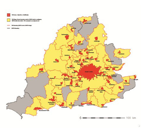
The global mega-city region unveiledSo the megacity region studied in Europe was not simply a highly interconnected urbanised space, it was a potential landscape of the competitive international economy. Decades earlier Peter had foreseen the importance of the role of new economy specialised global financial, business and professional services in the generation of internationally competitive urban regions. The rapidly changing new millennium regional landscapes of world cities in the US, Europe and East Asia were not only distinguished by intensifying movement into, out of, and within them, but by the apparent spreading out, spatially, of global city work and lifestyles. Functionally networked both globally and locally, in an integrating world economy, these extensive mega-city regions were becoming globalized phenomena. The mega-city region concept used in POLYNET therefore resonated with Scott's (2001) global city-region however a notable distinction was the inclusion of Peter's 1966 world city regions', the Randstad and the Rhine-Ruhr, and other urban regions not given prominence in the global cities' literature (Sassen, 2001) in addition to London and Paris. Global or globalizing mega-city regions are networked by complex flows of people, goods and information. The research therefore attempted ambit iously to map the complex flows that characterize the eight mega-city regions not only of people such as in physical commuting and business travel, but of ideas that travel through business networks in the form of face-to-face and virtual communications of all kinds (Pain and Hall, 2008). The results are reported in a book, The Polycentric Metropolis: Learning from Mega-City Regions in Europe published by Earthscan (Hall and Pain, 2006) and in numerous articles written since the completion of the study. Two types of region two types of mega-city region?Peter's past thinking was to prove highly relevant to issues of regional definition and analysis. In 1970, in Chapter 2 of his book text Theory and Practice of Regional Planning , Peter had considered the ideas of the French writer Jacques-Raoul Boudeville (1966) who defined two different types of region. This distinction was to have strong resonance with a critical difference between two types of mega-city region identified in the POLYNET study (Hall and Pain, 2006; Pain, et al., 2006; Taylor and Pain, 2007; Pain, 2008). Boudeville's first regional type was called a homogenous or statistically uniform or static region which exhibited statistical uniformity within a certain range based on a particular criterion, for example, population density. A contiguity constraint was imposed, in other words, for a homogenous region to be statistically uniform, its component areas must be homogenous and contiguous with each other for the same criterion (1970, pp. 14-15). Principal components analysis was then used to define real natural regions on the basis of statistical variations and areas of similarity for more than one criterion (1970, p. 15). His second regional type was called a nodal or dynamic flow region. This type of region reflected patterns of movement in geographical space, for example commuting. In 1970, Peter had noted the potential for these regional types' to inform analysis. For example he referred to the potential use of data on periodic or regular trips such as business men travelling on their regular routes (1970, p. 15) as applied, together with commuting and other flow data in the POLYNET study. He also foresaw that flow analysis could be applied to larger scale commodity movements which have been the focus of subsequent US megaregion' studies, for example Catherine Ross's research on megaregion freight and commodity flows and their economic and environmental impacts (http://www.coa.gatech.edu/people/catherine-ross; Ross, 2009). A characteristic of Boudeville's flow regions was their nodal or hierarchic structure whereby flows out of smaller centres converge and coalesce in bigger ones; in turn, the bigger flows from these bigger centres, together with flows of smaller centres, may flow into a bigger centre still. (1970, pp. 15-16). This conceptualization of the network architecture of a flow region was later illustrated by patterns of daily commuting in the POLYNET study which referred to the contiguity of daily travel to work areas, or FURs, to describe the functional mega-city region (see Figures 1-3). Making reference to the 1930s work of Walter Christaller, Peter saw in 1970 that the systems of flow described by Boudeville could potentially also correspond, in a systematic way in many cases to levels of economic activity which are associated with the centres or nodes themselves. They form, therefore, a sensitive guide to the functioning of the local economy. (1970, p. 16). He referred specifically to the economic significance of flows of population engaged in non-primary industries which were later to be the critical focus of the POLYNET research. Although Peter never referred directly to Boudeville's work or to his Theory and Practice of Regional Planning analysis when we designed the POLYNET project, the two regional types that Boudeville had described can be seen in retrospect to have common reference points with mega-city region distinctions that were later identified. Boudeville's flow region corresponds to what was termed in POLYNET a functionally polycentric' mega-city region. This mega-city region type is interconnected by networks and flows at multiple global to local scales. Significantly, the more global the networks and the flows of a city are, the more global is its mega-city region. Boudeville's homogenous region corresponds to what was termed a morphologically polycentric' mega-city region in POLYNET, for example the Rhine-Ruhr and the Randstad. This mega-city regional type has a profile of statistical similarity, for example the population size of the urban centres in a mega-city region, giving an impression of spatially balanced development, for example, the Rhine-Ruhr, Germany, and the Randstad, Netherlands, compared to South East England ( see Figures 1, 2 and 3). Notably, this type of mega-city region was found to be less global' and more static' than the functionally polycentric' mega-city region, South East England (Pain, 2006; Pain, 2008; Pain, 2011b). Figure 1: South East England Mega-City Region : Constituent FURs
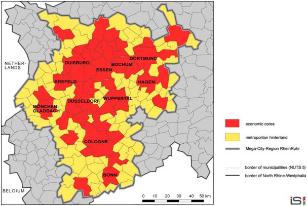
Source: Hall, P. and Green, N., 2005, p. 4. Figure 2: Rhine-Ruhr Mega-City Region: Constituent FURs
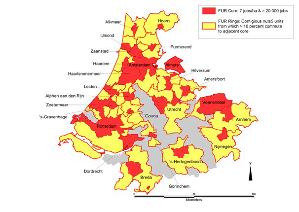
Source: Knapp et al., 2005, p. 3. Figure 3: The Randstad Mega-City Region: Constituent FURs
Source: Werff et al., 2005, p. 3. Of significance is what the study revealed about the importance of different roles and functions of the global or world cities that generate mega-city regions. The two different types of mega-city region identified - functionally polycentric regions, versus morphologically polycentric regions are being used differently by advanced business services networks as part of their global, European and national strategy. Regions that are more morphologically polycentric, containing an even distribution of cities of a similar population size, are less well functionally integrated and less well connected to global advanced business services networks, for example the Randstad, Netherlands and the Rhine-Ruhr, Germany. On the other hand, high global network connectivity of one city was associated with a distinctive mega-city region expansion process whereby global functions also become concentrated in proximate centres leading to real functional polycentricity, exemplified in South East England. Furthermore the contribution of morphological polycentricity to regional sustainable development priorities was shown to be highly questionable. The rising level of cross-cutting travel has unsustainable environmental effects. In the Randstad for example, the urban concentration and critical mass required to support efficient public transportation was missing and planning policies for the containment of urban areas were found to be failing. Meanwhile the Randstad was shown not to have a balanced economic structure even though it exhibits morphological polycentricity. Reflecting on Boudeville's terminologies cited by Peter in 1970, the regional distinction made in POLYNET can therefore usefully in retrospect be specified as: I - A dynamic flow/nodal mega-city region (for example, South East England) and II - A static/homogenous mega-city region (for example, the Randstad, Netherlands). Two mega-city region processesA dynamic flow/nodal versus static/homogenous conceptualization of the two mega-city region types has resonance with later reflection on the POLYNET results which drew on Jacobs (1969) and Castells (1996) to inform a programme of US megaregion' research. In Taylor and Pain, 2007, a distinction is drawn between two mega-city region processes Process A Mega-city region expansion' and Process B - Construction of mega-regions of proximate cities'. Process A Mega-city region expansion' is that identified in South East England where mega-city region expansion is occurring in spite of the primacy of London. London's expansion is enveloping previously proximate cities and towns (for example Reading, Berkshire) which exhibit multi-sector advanced business services clustering and a strong presence of international networks and connectivity. This process is one of a diffusion of urban functions envisaged by Jacobs, but at a much larger geographical scale creating a functionally polycentric global mega-city region' structure with multiple connections to the world economy (Pain and Hall, 2006). Process B Construction of mega-regions of proximate cities' is identified in mega-city regions exhibiting varying degrees of lesser primacy than London. Of note, these regions showed sectoral specialisation between their cities (for example banking/advertising in Amsterdam, architecture/logistics in Rotterdam, management consultancy in Utrecht-Amersfoort ) and a functional differentiation in terms of the scale of their business network connections with one leading city (for example, Amsterdam and Düsseldorf) which are dominant for global connectivities. The result is a primate centre functionally surrounded by a homogenous or static region that is functionally disconnected from the primate city. As Taylor and Pain put it, Thus rather than creating a Jacobsean city-region, process B is about constructing mega-regions of proximate cities [or] an urban region with holes in it (2007). Returning to 1970, in Peter's discussion of the difficulties arising from the application of Boudeville's regional distinction in British situations, he illustrated the kernel of future debates in spatial analysis in relation to questions of scale and governance. In considering the question of scale, he notes that,
Furthermore he saw that,
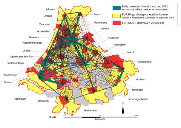
He therefore drew attention to the contested nature of the region', its scale and its definition, that would come to be subjects of urgent critical debate in the 2000s (Harrison and Pain, 2012; Pain and Van Hamme, 2014) . The POLYNET research revealed p olycentrism to be a scale-sensitive phenomenon. The globalization of advanced business services activity is generating functional polycentricities at global to local scales, including the mega-city region scale and an emerging transnational, metacity' scale (Pain, 2010). This finding has important implications for policy and planning as illustrated in England by Government priorities introduced in 2014 for a Northern Powerhouse' comprising the Liverpool, Manchester, Leeds, Sheffield, Hull and Newcastle city regions, which is effectively one multi-centred mega-city region. An advantage of understanding mega-city regions as a process is that overlapping scales and the likely reality that different processes coincide in the same space can be taken into account. The issues arising for mega-city regions planning and governance will be considered shortly. Mega-city region zones of hope How sustainable?Returning briefly to the year 1963, in London 2000 Peter had foretold part of this future mega-city region reality in his vision of London's evolution into a multi-centred region. It was here that he identified the coming of a mega-city-region that would be 120 miles wide and contain no less than 28 new towns. A fictional family, the Dumills, were living in a future compact new town to be called Hamstreet near Ashford in Kent built in 1973. The story was lighthearted but, importantly, it predicted a South East England society that was to prove incredibly accurate. Sophisticated city consumption behaviours had spread across the London region. Hamstreet had been designed to have a target population of 95,000 and that target was under revision to cater for next generation families. 70,000 of that target population would be able to walk to the town centre shopping area. But despite its design as a self-contained community, three of the four members of the Dumill family do not work in Hamstreet. As an ex-city dweller, Mr Dumill commutes daily to work in London. Moreover, while Hamstreet's fictional planners were alarmed at growing violation of the new town enclosed community ideal, they came to accept it as an inevitable consequence of increasing personal mobility: Hamstreeters thought as little of going 25 miles to work as of driving 50 miles in the evening to see friends, or going over to Brittany for a weekend (London 2000 (1963) reproduced in The Dumills Londoners 2000, Town & Country Planning , February, 2000, p. 44). Furthermore, for the Londoners of 2000, distance is no longer an object. They learned to do without cars for much of their working day, but for living their own lives the car has become part of themselves. Just as they no longer can work in isolated communities, so they can no longer form their friendships and their social lives within bounds of space. For them Hammersmith to Dover has no more significance than would Hammersmith to Hampstead in 1960 (2000, p. 60). The scenario of the spread of city consumption patterns and individual travel by car across an enlarging functionally networked mega-city region was also discussed in relation to The World Cities' specifically by Peter in 1966, where he also foresaw the governance and planning challenges that would arise in South East England four decades later. As a reverse commuting resident of West London driving his Citroen Deux Chevaux car some 40 miles daily down the M4 to work at the University of Reading in the 1970s, Peter would not have been unfamiliar with the reality of complex patterns of mobility that would be generated by the residents of a multi-centred region with a world city at its centre. Yet, in the year 2000, reflecting on how his 1963 vision had turned out, he spoke of his failure to spot the development of Milton Keynes but did not discuss the implication of The Dumills' lifestyle, i.e. that new towns scattered across a regional landscape close to London might be less self-contained than Howard could ever have predicted in writing Tomorrow in 1898. Peter commented optimistically in The 1962 view from 2000 (Hall, 2000) that
His continued vision of a polycentric Howard-style London region populated by more new towns by the year 2000 imitated the Dutch Randstad development model. But this was shortly prior to the POLYNET study that was to identify the unsustainable environmental impacts associated with morphological polycentricity due to intense cross-cutting personal mobility by car (see Figure 4). Figure 4: The Randstad Mega-City Region: Commuting, 2002
Source: De Werff, et al ., 2005, p. 14 and Hall and Pain, 2006, p. 38. But, as will be seen, by the year 2014 at the end of Peter's life, he began to see how Howard's Social City might be applied more sustainably in contemporary European mega-city regions. Two types of regional planning: Two types of mega-city region planning?Returning once more to Theory and Practice of Regional Planning (1970), in what ways can Peter's consideration of a distinction between two types of British regional governance inform the mega-city region planning challenges of today? Drawing heavily on Self (1967), he identified two types of regional planning, the first deriving from an economics or regional science discipline approach and the second from ecology, design and land economics. The first type of regional planning referred to as national/regional concerned national investment allocation planning in which policy aims to steer economic growth spatially by introducing measures by using development incentives and steering resource allocation. Peter argued that this type of regional planning was the one that had become the dominant European model (Pain, 2011a). The second type of regional planning referred to as regional/local concerned the planning of the city and city-region. Here Peter pointed to the blend of resource, land use and design policies that relate to this scale which he referred to as an intermixing of non-physical planning and physical planning (1970, p. 23). Peter made the interesting point that these two types of British regional planning had historically rarely appeared to run together and that when they had done so it could be argued that the marriage was a forced one (1970, p. 24). The POLYNET results suggest that the two types of mega-city region demand that there be two types of regional planning which need to run together. He went on to identify the problem that the definition of regional and city-region boundaries is entirely dependent on the criteria used. Thus the regional scale will be variable and moreover whole sets of regions can be observed at different levels (p. 16). He identifies the greater difficulty, that by definition, there is no necessary correspondence between homogenous regions and nodal regions (p. 17). These issues clearly had important implications for planning and regional governance structures and agendas which had not been explored in depth before the POLYNET study. Coordinated planning was found to be compromised by governance challenges in all of the mega-city regions studied. Halbert and co-authors (Halbert, et. al ., 2006, pp. 206-218) emphasise that planning approaches at European Union, member state and sub-national levels need to, but do not, engage with the sustainability challenges posed by contemporary mega-city region development,
The authors give examples of the lack of appropriate governance structures in mega-city regions that are identified in the study as having, a prevalent soft and shifting functional geography (Halbert, et. al., 2006, pp. 206-218): In the Zürich-Basel case Swiss policymakers,
In the case of Paris,
In South East England, in spite of growing recognition that city-region boundaries are fuzzy',
Since advanced business services networks operate in and connect multiple cities functionally, territorial competition between cities is unhelpful especially since cities do not fit neatly into regional boxes'. As Peter pointed out in 1970, Whole sets of city regions can be defined depending on the criterion you choose for the nodal region and the space of flows in the contemporary global service economy is agile, the specification of mega-city region boundaries has ultimately proved a fruitless and dangerous exercise (see Harrison and Pain, 2012). Taylor and Pain (2007) conclude that,
The regional planning protagonist - Final reflectionsIn introducing this essay I made reference to three intentions that have proved to be interlinked: First, to research the emergence of the contemporary mega-city region as observed and understood by Peter whose analytical lens was focused obsessively on the spatial form and functioning of cities for more than half a century; second, to trace how a critical relationship between Peter's two great passions, cities on the one hand and railways on the other, ultimately allowed him to inform a new, spatial vision for more sustainable mega-city regions; and third, to draw attention to the part played by the breadth of Peter's disciplinary positioning, first and foremost in geography, that allowed him to contribute critical insights to planning practice. The short trawl through a selection of Peter's publications has highlighted how his early interest in the historical-economic geography of London during his PhD, was to evolve over time, introducing an interdisciplinary spatial perspective to urban policy and planning debate. His early ideas for the roll-out of Social City new towns across South East England can be viewed in retrospect as having been destined (had they been realised) to contribute to a regional development pattern in North West Europe that is now recognised as generating unsustainable intense, cross-cutting physical flows of people by car. Howard's Social City model, upon which Peter's new towns vision was based, was formulated years before the advent of mass car ownership. The ideal Garden City of 1902 was predicated on a totally different model of mobility needs, expectations and means to that of today, i.e. the use of feet, and even horses, instead of cars. Thus the sustainability of Howard's model clearly requires critical re-evaluation and re-working ( Adams, et. al., 2015). Moreover, although urban containment' had become a planning objective when London 2000 was written, this was years before the societal changes that would present new challenges to containment policy and before widespread recognition of linked climate change and environmental sustainability imperatives. Ultimately, Peter's two great passions were to come together in his pursuit of a model for the future sustainable development of mature polycentric mega-city regions. He came to realise the need to review his regional vision post-POLYNET, and in the same year that Good Cities, Better Lives (2013a) was published, he addressed the crucial question that had eluded attention in his earlier work in Refreshing the parts that other transport cannot reach' (Hall, 2013b):
In Sociable Cities (Hall and Ward, 2014), recognising the increasing urgency of the challenge to address the present and future housing needs of London's growing population beyond its boundaries, post-SINTROPHER, Peter saw the virtue of the European model for the development of transit-linked urban extensions' within short distances of existing town centres. Because UK densities of dispersed smaller urban centres potentially suitable for expansion would prohibit tram links, he proposed rapid bus transit to connect the new settlements to high-speed train stations. However to achieve such a vision in England, a strategic plan to succeed the ODPM (2003, 2004) strategy for Sustainable Communities' would need to be reinstated and local communities and authorities would need to cooperate to deliver it. Peter's long held view was that Britain was in need of a radical new interventionist approach to planning and governance at the two levels he had discussed in Theory & Practice of Regional Planning in 1970: first strong state engagement with national/regional level priorities and central policies for infrastructure investment throughout the country and, second, devolution of financial levers to empower regional/local level planning and governance for real functional city-regions. Writing in 1975, Peter had mourned the loss of joined up regional planning after the demise of the 1950s Ministry of Town and Country Planning regional offices in each of Britain's main provincial cities,
And following the demise of the regional planning system that had eventually been introduced in England by a Labour Government, there are no longer any real vehicles for the development of long term, coordinated spatial strategies and co-operation between Local Authorities, Local Enterprise Partnerships (LEPs) and cities with combined authorities and City Mayors across England. Peter was a strong advocate for strategic planning however it can be argued that it was his disciplinary positioning as a planning outsider' that allowed him to make his most important contribution to good cities, better lives and better planning, a fearlessness in remorselessly questioning the status quo. Given his longstanding contributions to debate on a strategic planning vision for London, it is no surprise that he came to study the global mega-city region in South East England that had been emerging throughout his career in what proved to be its final decade. Looking back, t he mega-city region he identified in England and researched with colleagues across North West Europe seems to have been a natural development from everything in Peter's career that had gone before. Significantly, the culmination of that research has ongoing relevance for the sustainable management of urbanization worldwide. REFERENCESAdams, D., Larkham, P. and Pain, K. (2015) Viewpoint: Revaluating the place of urban planning history, Town Planning Review , 86(2), pp. 373-379). Blowers, A. and Pain, K. (1999) The Unsustainable City? In Understanding Cities : Unruly Cities? Order/Disorder , Pile, S., Brook, C. and Mooney, G. (eds.), London, Routledge, pp. 247-298. Boudeville, J.R. (1966) Problems of Regional Economic Planning , Edinburgh, Edinburgh University Press. Breheny, M.J and Hall, P. (eds.) (1996) The people - where will they go? National report of the TCPA Regional Inquiry into Housing Need and Provision in England, London, Town and Country Planning Association. Castells, M. and Hall, P. (1994) Technopoles of the World: The Making of 21 st Century Industrial Complexes , London, Routledge. Castells, M. (1996) The Information Age: Economy, Society and Culture, Vol.1: The Rise of the Network Society , Oxford, Blackwell. EC (1999) ESDP: European Spatial Development Perspective: Towards Balanced and Sustainable Development of the Territory of the European Union , Brussels, European Commission. Friedmann J. (1986) The world city hypothesis, Development and Change , 17, 6983. Geddes, P. (1915) Cities in Evolution. An introduction to the town planning movement and to the study of civics, London, Williams. Gottman, J. (1961) Megalopolis. The urbanized northeastern seaboard of the United States, New York, The Twentieth Century Fund. Halbert, L., Pain, K. and Thierstein, A. (2006) European Polycentricity and Emerging Mega-city Regions: One size fits all' policy? Built Environment , 206-218. Hall, P. (1962) The Industries of London since 1861 , London, Hutchinson. Hall, P. (1963) London 2000 , London, Faber and Faber. Hall, P. (1966) The World Cities , London, Weidenfeld and Nicholson. Hall, P. (1970) Theory & Practice of Regional Planning , London, Pemberton Books. Hall, P. (1975) Urban and Regional Planning , Harmondsworth, Penguin Books Ltd. Hall, P. (1985) The people: Where will they go? The Planner , 71, 4, 3-12. Hall, P. (1986) From the Unsocial City to the Social City, The Planner , March, 17-24. Hall, P. (1987) The Anatomy of Job Creation: Nations, Regions and Cities in the 1960s and 1970s, Regional Studies , 21, 95-106. Hall, P. (1988) The Industrial Revolution in Reverse? The Planner , January, 15-19. Hall, P. (1989) London 2001, London, Unwin Hyman Ltd. Hall, P. (1991) A New Strategy for the South East, The Planner , 22 nd March, 6-9. Hall, P. (1999) Planning for the Mega-City: A New Eastern Asian Urban Form? In East West Perspectives on 21st Century Urban Development: Sustainable Eastern and Western Cities in the New Millennium, Brotchie, J., Newton, P., Hall, P. and Dickey, J. (eds.), Aldershot, Ashgate, pp. 336. Hall, P. (2000) The 1962 view from 2000, Town & Country Planning , February. Hall, P. (2007) London Voices, London Lives: Tales from a Working Capital , Bristol, Policy Press. Hall, P. (2013a) Good Cities, Better Lives: How Europe Discovered the Lost Art of Urbanism , Routledge. Hall, P. (2013b) Refreshing the parts that other transport cannot reach, Town & Country Planning , March, 121-132. Hall, P. (2014a) We have a problem so what to do? Town & Country Planning , 2014, 114-117. Hall, P. (2014b) Apologia pro vita sua, Town & Country Planning , August, 317-325. Hall, P. and Green, N. (2005) Polynet Action 1.1 Commuting & the Definition of Functional Urban Regions, South East England , London, Institute of Community Studies/The Young Foundation. Hall, P. and Pain, K. (eds.) (2006) The Polycentric Metropolis: Learning from Mega-City Regions in Europe, London, Earthscan. Hall, P., Thomas, R., Gracey, H. and Drewett, R. (1973) The Containment of Urban England , London, George Allen and Unwin. Hall, P. and Ward, C. (1998) Sociable cities: Legacy of Ebenezer Howard , Chichester, John Wiley & Sons. Hall, P. and Ward, C. (2014) Sociable cities: The 21st-Century Reinvention of the Garden City , London, Routledge. Harrison, J. and Pain, K. (2012) Global Cities, Volume IV: Planning and Governance of Cities in Globalization , London, Routledge. Howard, E. (1902) Garden Cities of Tomorrow, London, Swann-Sonnenschein & Co Ltd, pp. 141151. Jacobs, J. (1969) The Economy of Cities, New York, Random House. Knapp, W., Scherhag, D. and Schmitt, P. (2005) Polynet Action 1.1 Commuting & the Definition of Functional Urban Regions: Rhine-Ruhr , London, Institute of Community Studies/The Young Foundation. ODPM (2003) Sustainable Communities: Building for the Future, London, Office of the Deputy Prime Minister. ODPM (2004) Creating Sustainable Communities: Making it Happen the Northern Way, London Office of the Deputy Prime Minister. Massey, D. (1983) The Shape of Things to Come, Marxism Today , April, 18-27. Pahl, R. (1986) Ray Pahl on Hall's Social City, The Planner , April, 10. Pain, K. (2006) Policy Challenges of Functional Polycentricity in a Global Mega-City Region: South East England'', Built Environment , 32(2), 194-205. Pain, K . (2008) Examining Core-Periphery Relationships in a Global Mega-City Region - The Case of London and South East England, Regional Studies, 42(8), 1161-1172. Pain, K. (2010) The Emerging Metacity in North Western Europe and Policy Ramifications for Sustainable Transport Networks. In The emerging cross-border mega-city region and sustainable transportation, KOTI-EWC 2010 Special Report, Mo, C., Kim, Y.H. (eds.), Hawaii/Korea, East-West Center/The Korea Transport Institute pp. 2 27. Pain, K. (2011a) New Worlds' for Old'? Twenty-First-Century Century Gateways and Corridors: Reflections on a European spatial perspective, International Journal of Urban & Regional Research, 35(6), 1154-74. Pain, K. (2011b) Spatial transformations of cities Global City Region? In Mega City Region? International Handbook of Globalization and World Cities , Derudder, B., Hoyler, M., Taylor, P.J., Witlox, F. (eds.), Cheltenham, Edward Elgar, pp. 83-93. Pain, K. , Hall, P., Potts, G. and Walker, D. (2006) South East England: Global Constellation. In The Polycentric Metropolis: Learning from Mega-City Regions in Europe , Hall, P. and Pain, K. (eds.), London, Earthscan, pp. 125-136. Pain, K. and Hall, P. (2008) Informational Quantity versus Informational Quality: The perils of navigating the space of flows, Regional Studies, 42(8), 1065-1077. Pain, K. and Van Hamme, G. (2014) Changing Urban and Regional Relations in a Globalizing World: Europe as a Global Macro-Region, Cheltenham, E dward Elgar. Pain, K. and Van Hamme, G. (2015) Europe as a Global Macro-Region: How is economic geography changing the Cohesion policy challenge? In Regional Studies Association Conference, Challenges for the New Cohesion Policy in 2014-2020: An Academic and Policy Debate , 04-06 February 2015, Riga, Latvia, Regional Studies Association. Reid, M. (2014) Peter Hall will we ever see his like again? The Planner , September, 5. Ross, C. (2009) Planning for Global Competitiveness, Washington, Island Press. Sassen, S. (1991) The Global City , Princeton, NJ, Princeton University Press. Sassen, S. (2001, 2nd edition) The Global City , Princeton, NJ, Princeton University Press. Scott, A. J. (ed.) (2001) Global City-Regions: Trends, Theory, Policy, Oxford, Oxford University Press. Self, P. (1967) Regional Planning in Britain: Analysis and Evaluation, Regional Studies , 1, 3-10. South East Economic Planning Council (1967) A Strategy for the South East: A First Report by the South East Economic Planning Council, London, HMSO. South East Joint Planning Team (1970) Strategic Plan for the South East: A Framework Report by the South East Joint Planning Team , London, HMSO. Taylor, P.J. and Pain, K. (2007) Polycentric Mega-city regions: Exploratory Research from Western Europe. In The Healdsburg Research Seminar on Megaregions , Todorovich, P. (ed.) The Healdsburg Research Seminar on Megaregions, Healdsburg, USA, Lincoln Institute of Land Policy and Regional Plan Association, pp. 59-67. Tewdwr-Jones, M., Phelps, N. and Freestone, R. (2014) The Planning Imagination: Peter Hall and the Study of Urban and Regional Planning , Routledge. Werff, M. van der, Lambregts, B., Kapoen, L. and Kloosterman, R. (2005) POLYNET Action 1.1: Commuting & the Definition of Functional Urban Regions: The Randstad, London, Institute of Community Studies/The Young Foundation & Polynet Partners. NOTES* Kathy Pain, School of Real Estate & Planning, University of Reading, e-mail: k.pain@reading.ac.uk.
Note: This Research Bulletin has been published in R.D. Knowles and C. Rozenblat (eds) (2016) Sir Peter Hall: Pioneer in Regional Planning, Transport and Urban Geography Springer, pp. 59-80. |
||