GaWC Research Bulletin 420 |
|
|
|
This Research Bulletin has been published in European Planning Studies doi:10.1080/09654313.2013.771619 Please refer to the published version when quoting the paper
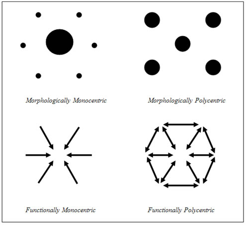
Polycentricity in Planning and PracticeWhereas European spatial planning in the 1980s was mainly concerned with land-use regulation and specific development projects, the 1990s were characterised by a revival of strategic spatial planning (Albrechts et al., 2003; Albrechts, 2004; Healey, 2004). This reorientation in spatial planning meant a shift in focus from the physical planning of space-using functions such as housing, industry, transport and nature to the development of strategic frameworks and new visions for regional development. This resurgence of interest in strategic spatial planning can be seen as a departure from the neoconservative and postmodern disbelief in the ‘makeability of society’ (Albrechts, 2004) and is fuelled in part by the problems of coordinating public policy, promoting urban and regional competitiveness through the development of a collective asset base and mitigating inequalities of opportunity across cities and regions (Healey, 2004). In this ‘new’ strategic spatial planning (cf. Healey, 2004), polycentricity is a catchphrase; polycentric development policies have mainly been introduced to encourage a more balanced spatial distribution of economic activities between geographic units (cities, regions) across an area as well as higher levels of urban and regional competitiveness (Meijers and Romein, 2003). The rationale behind such policies differs from area to area and ranges from the overconcentration of economic activities in one place and the underutilisation of resources in other places to the desire to prevent exodus from rural areas, promote environmentally sustainable development, and increase economic and social cohesion and solidarity in general (Meijers et al., 2007). Polycentricity can mean different things at different geographical scales (Kloosterman and Musterd, 2001; Davoudi, 2003; Meijers et al., 2007; Vandermotten et al., 2008). At the level of the European Union, polycentricity has mainly been introduced to stimulate growth outside of the areas known as the ‘Pentagon’ “to ensure regionally balanced development, and create global economy integration zones” (Commission of European Community, 1999, para. 67). At the national level, polycentric development policies have aimed to achieve competitiveness and cohesion by reducing disparities in development between regions and between cities at different levels in the national urban hierarchy (Meijers et al., 2007). At the regional level, academic discussion and policy debate has predominantly focused on the development of Polycentric Urban Regions (PURs), which can be best described as a set of historically and spatially separate metropolitan areas comprising a larger, functionally interrelated urban region (Kloosterman and Musterd, 2001). As indicated by Faludi (2004), such polycentric spatial constellations are supposed to be more competitive than their monocentric counterparts because they provide opportunities to take advantage of some of the positive factors associated with large agglomerations, such as broader labour markets, luxury goods and services and airports, while avoiding some of the negative factors associated with such agglomerations, such as pollution, crime and congestion. At the same time, other scholars have argued that the integration of separate metropolitan areas does not necessarily ensure that they will enjoy the competitive advantages of a similar-sized monocentric region (Bailey and Turok, 2001; Lee and Gordon, 2007; Meijers and Burger, 2010; Veneri and Burgalassi, 2012). Despite the scale-dependent interpretation of polycentricity, one of the common characteristics of polycentric development policies is that they all seek the spatial integration of particular regions (i.e., the enlargement of particular functional regions) through urban network development. At the continental and national levels, it is believed that equality will be improved by strengthening urban-rural relationships through the creation of a network of internationally accessible metropolitan regions (well-distributed across the European Union or across the country in question). At the regional level, functional linkages between medium-sized cities and towns within a PUR are promoted to achieve synergies between the different parts of the region (Meijers, 2005) and so that they will be able to compete with their monocentric counterparts, such as London and Paris (Dieleman and Faludi, 1998). This is supposed to create a favourable setting for economic growth, especially when the cities and towns in such an urban network complement each other in terms of their economic specialisations. Polycentric development policies seem to combine the ostensibly conflicting objectives of regional cohesion and competitiveness (Waterhout, 2002)1. Although polycentricity has featured prominently as a normative strategic planning concept in policy documents and the academic literature, less attention has been paid to polycentricity as an analytical construct for studying the spatial organisation of geographic areas (Van Houtum and Lagendijk, 2001; Davoudi, 2003). Indeed, most of the planning and geography literature has focused on polycentricity as a spatial-planning vision as well as on capacity-building in and governance of polycentric areas, where polycentricity is perceived as a goal in itself. However, the number of studies that assess empirically how well the polycentric model fits the reality of contemporary urban systems is gradually increasing. This development has been spurred not only by an increase in the availability of data on urban networks but also by the increasing need to assess the validity and usefulness of the notion of polycentricity in the context of polycentric development policies (Meijers, 2008). In particular, many scholars have questioned the extent to which PURs really operate as functionally integrated entities. Although it is often argued that the monocentric city is being replaced by the polycentric urban network as the dominant form of spatial organisation, it remains unclear to what extent the PUR model accurately reflects spatial reality. The existence of multiple urban centres in close proximity to each other does not necessarily even imply that there are strong functional links between those centres, let alone that the ostensible PUR is functionally polycentric in that the orientation of the functional links (for example, commuting, shopping, and trade) within that PUR are multidirectional. Taking these considerations into account, several scholars have argued that there is limited degree of urban network formation at the level of the PUR, even in regions that are considered archetypical PURs from a morphological point of view, such as the Basque country (Van Houtum and Lagendijk, 2001; Meijers et al., 2008), the Randstad in Holland (Lambooy, 1998; Lambregts et al., 2006; Van Oort et al., 2010), and the Flemish Diamond (Albrechts, 2001; Cabus and Vanhaverbeke, 2006; Hanssens et al., 2012). As a PUR cannot exist in practical terms without a minimum amount of interaction between the various parts (Champion, 2001; Parr, 2004; Governa and Salone, 2005), this purported lack of integration raises serious questions for the many policy attempts to initiate and sustain polycentric economic-development trajectories in Europe However, Lambregts (2009) rightly notes that the degree of polycentricity and interdependence between cities that can be seen in a particular region is highly dependent on the indicators used to measure it. Urban networks are multiplex phenomena and, therefore, polycentricity and interdependencies can be studied by evaluating different types of functional linkage between cities and regions, for example, commuter trips (Van der Laan, 1998; Aguilera, 2005; De Goei et al., 2010; Burger et al., 2011; Champion and Coombes, 2012; Vasanen, 2012), telephone calls (Camagni and Salone, 1993; Halbert, 2008), intra-firm networks (e.g., the POLYNET study documented in Hall and Pain (2006) and Hoyler et al.(2008)), and inter-firm networks (Van Oort et al., 2010; Hanssens et al., 2012). The spatial organisation of each of these types of functional linkage is not necessarily similar and, therefore, a region may appear polycentric and spatially integrated with respect to one type of functional linkage but monocentric and loosely connected with respect to another type of functional linkage2. Most of the empirical studies have evaluated the spatial organisation of regions by looking only at one, or at most two or three, types of functional linkage. Similarly, spatial planners have limited themselves to mere abstract descriptions of concepts such as the PUR and have difficulty envisioning regions in a more refined way, partly due to a dearth of data on how a given city or town is linked with other places in the wider territory (Healey, 2004; 2006). The aim of this paper is to stimulate further discussion on the multiplexity of urban networks in the context of polycentric development policies and the ‘relational complexity’ (cf. Healey, 2006) of urban regions. Focusing on the PUR and comparing the geographic scope and spatial structure of different functional networks, we analyse the extent to which different urban networks overlap. In this study, we examine the networks of the Randstad region in the Netherlands, which has been described as an archetypical PUR in the geography and planning literature (Lambregts et al., 2005; 2006). We argue that by taking into account the multiplexity of urban networks, the meaning of functional polycentricity, spatial interdependence and urban network development at the level of the PUR from an analytical point of view can be better understood. The remainder of this paper is organised as follows. Section 2 gives a more detailed introduction to the notions of functional polycentricity, spatial interdependencies, and the multiplexity of urban networks. Section 3 introduces the Randstad region in the Netherlands as an empirical setting and describes the data and the methodology. Section 4 summarises the empirical results, and Section 5 presents a discussion of the implications and our conclusions. Polycentric Urban Regions and the Multiplexity of Urban NetworksPolycentric Urban Regions, Functional Polycentricity and Spatial InterdependenciesRecent studies assessing the spatial reality of the PUR model have drawn particular attention to the degree of functional polycentricity and interdependence between cities of the regions so described (e.g., Hall and Pain, 2006; De Goei et al., 2010; Van Oort et al., 2010; Burger et al., 2011; Champion and Coombes, 2012; Hanssens et al., 2012). Functional polycentricity defines the importance of particular centres in an urban network on the basis of their centrality within that network and assesses whether the centres are equally important in terms of their network position. Hence, a functionally monocentric territory is characterized by a hierarchy of centres. Because it is based on the multidirectionality of the links in urban networks, the measurement of functional polycentricity differs from the measurement of morphological polycentricity, which is based on the extent to which people, companies or employment are evenly distributed across the different centres within a territory (Green, 2007; Burger and Meijers, 2012; see Figure 1). In other words, the morphological approach focuses on the characteristics of nodes rather than the characteristics of links; in the morphological approach, the importance of the centres is usually assessed based on their relative size and a monocentric territory is characterized by the presence of one dominant centre. As the application of the PUR model is largely based on the ostensible existence of functional links between different centres in terms of the physical movement of goods, people and services, the notion of functional polycentricity is coming to be more widely used in the empirical literature than its morphological counterpart (Burger et al., 2011). Figure 1: Morphological Polycentricity versus Functional Polycentricity
Nevertheless, the functional and morphological approaches share the same basic principle, in that both characterise polycentric areas as consisting of a group of urban centres that are relatively equal in terms of their importance (Kloosterman and Lambregts, 2001; Meijers, 2008). Drawing on central-place theory (Christaller, 1933; Lösch, 1944), and the urban-systems literature (Berry, 1964; Bourne and Simmons, 1978), Burger and Meijers (2012) draw a theoretical link between morphological and functional polycentricity by arguing that if the importance of a city is only determined on the basis of its size, part of that importance can be attributed to the city being a provider of jobs, goods, services and capital to its own population and another part can be attributed to the city being a provider of jobs, goods, services and capital to other places. For example, the total employment in a city can be broken down into 1) employment of people who both work and live in that city and 2) employment of people who work in that city but live elsewhere (i.e., people who are incoming commuters). In this example, the morphological approach would evaluate the spatial distribution of total employment, whereas the functional approach would evaluate the spatial distribution of incoming commuting flows only. In a functionally polycentric system, there is no obvious orientation towards any particular centre, and the centres are relatively equal in terms of the magnitude of their external linkages or their centrality. Another important aspect of a PUR is its degree of interdependence between cities or its degree of spatial integration. Within the PUR model, spatial interdependencies can be seen as referring to the existence of functional links between historically and geographically separate metropolitan areas. De Goei et al. (2010) and Van Oort et al. (2010) have argued that a PUR functions as an urban network if the probability of interaction is determined solely by the sizes of the cities and towns in it and the physical distances between them. Hence, controlling for size and distance, interdependencies between cities within one part of PUR (e.g. within a certain subregion) should not be stronger than interdependencies between cities across different parts of the PUR (e.g., between subregions). A similar argument can be made with respect to functional polycentricity; if size and distance are controlled for, the interdependencies between cities at different levels of the urban hierarchy (e.g., core-periphery relationships) should not be stronger than the interdependencies between cities at the same level of the hierarchy (e.g. core-core relationships or periphery-periphery relationships). In analytical work on polycentricity, it is important to not to conflate the degree of spatial interdependence with the degree of functional polycentricity; they are different theoretical constructs (Burger and Meijers, 2012). There are spatial systems that are strongly networked as well as monocentric and spatial systems that are not networked at all but are polycentric. In fact, previous empirical research has shown that there is no correlation between the degree of functional polycentricity and degree of spatial interdependence, indicating that they should be treated as two distinct aspects of the spatial organisation of regions (Burger et al., 2011; Burger and Meijers, 2012). The Multiplexity of Urban NetworksIn the geography and planning literature, it is generally acknowledged that urban networks are multiplex in that they are comprised of ‘multidirectional flows of not only economic but also social, cultural and environmental activities’ (Davoudi, 2008, p. 51). Different places are functionally connected not only by labour-market relationships but also by trade, capital movement, and consumer travel as well as commutes for school, social visits and leisure trips (Masser, 1972; Lambooy, 1998; Turok and Bailey, 2004; Parr, 2005; Hewings and Parr, 2007; Van der Knaap, 2007). This results in a complex web of inter-regional relationships, where cities and regions are dependent on other cities and regions for education, labour, capital and intermediate goods as well as markets for products. Examples of different types of functional links are given in Table 1. Although the functional linkages differ in their economic importance (e.g., social visits versus trade), it should be noted that cities and regions are above all human phenomena and that they are as much social, cultural and environmental entities as economic entities (Davoudi, 2008). Although it can be argued that the PUR is mainly an economic concept that focuses on regional competitiveness and cohesion, strategic planning around PURs could well be extended to incorporate other policy fields. Table 1: Examples of Functional Linkages across Space
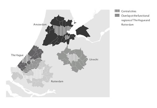
Although the multiplexity of urban networks has been widely recognised in the academic and policy discourse, most empirical studies have only used commuting data to analyse the functional spatial organisation of areas at the local and regional scale because they are often the only type of data available (Parr, 2005; De Goei et al., 2010)3. This is not by definition problematic, as commuter trips can be used as a surrogate representation for other types of spatial interactions in cases where 1) the other linkages shape the internal structure of metropolitan areas in the same manner that commuting does and 2) the geographical scope of the interactions is similar (Bode, 2008). The geographical scope and spatial structure of different functional linkages are undeniably related, at least to some extent, as many of these activities take place in the context of other activities (Masser, 1972). For example, an individual can travel from home to work, do some shopping during the lunch break, and play billiards with colleagues after work. A similar view is found in space-time geography (see, for example, Hägerstrand, 1970; Thrift, 1977), which examines how people fit their various daily activities into their space-time budget. These activity patterns are quintessentially interdependent because activities affect and constrain each other. In this paradigm, the institutions to which people belong (e.g., households and companies) and with which they interact (e.g., stores, schools, and other companies) can be treated similarly. However, different functional linkages do not necessarily have the same geographical scope, and no individual network can give a complete picture of the interdependencies between different cities and regions. It is quite clear that the geographical scope of commuting is generally smaller than that of corporate ownership and that people are willing to travel longer distances on recreational trips than for daily shopping. There are thus no uniquely definable regional boundaries, and the geometry of functional regions ‘is best characterized by multiplicity, fuzziness and overlaps’ (Davoudi, 2008, p. 57). Related research by Coombes and his colleagues has shown that the functional regional boundaries that can be drawn based on journeys to services or movement related to housing markets (measured by migration patterns) can be very different from the functional regional boundaries that can be drawn based on journeys to work (Coombes and Wymer, 2001; Robson et al., 2006). In addition, different places can fulfil different functions within an urban network, and places that are central with respect to one function are not necessarily central with respect to other functions. However, the most important cities are those that connect the global with the local in that they operate as places in which daily activity patterns, trade in goods and services, information and communication networks and corporate-control networks come together. From this premise, it follows that some functions will be more evenly distributed across different places than other functions; in particular, the more national- and international-level functions (e.g., corporate control) are concentrated in only a few places. The degree to which a region can be characterised as polycentric is then dependent to a certain extent on ‘the eye of the beholder’ (cf. Lambregts, 2005), as it is dependent on the lens through which it is assessed4. The discussion of the multiplexity of urban networks is not confined to analysing the co-existence of different space-time relationships and the spatial organisation of those relationships; it also inevitably draws attention to interdependencies between the different geographical scales (Van der Knaap, 2007). As we mentioned above, companies and households have a multiscalar spatial orientation with respect to the different activities that they undertake. Some of their activities are very local, whereas others transcend regional boundaries and thereby connect different geographical scales. For example, all of the international functions within a PUR may be concentrated in one city (for example Amsterdam, London, or Paris), but the manufacturers and service companies supplying such an international city and the highly educated workforce employed in that international city may be scattered across the wider urban region (for example, the Randstad in Holland, the Greater South East in Britain, or the Bassin Parisien). Therefore, if the position of the city within the global network of international cities changes, it also affects the labour and commodities markets of the wider urban region. Urban Networks in the Randstad RegionThe Empirical Setting: Randstad HollandThe Randstad is a conurbation in the western part of the Netherlands, in which four major cities, i.e., Amsterdam, Rotterdam, Den Haag, and Utrecht, and a number of smaller towns, including Delft, Dordrecht, Haarlem and Leiden, are situated in close proximity to each other. As shown in Figure 2, the Randstad can be conceptualised as consisting of four subregions, each of which includes one of the four major cities and the lower-order municipalities (i.e., suburbs, which may be secondary urban centres, villages or hamlets) that are centred around that city. In the literature on spatial structure, the Randstad has often been hailed as a prototypical PUR; since the publication of Werkcommissie Westen des Lands (Working Commission for the Western Netherlands) (1958) and the work of Sir Peter Hall in the 1960s (Hall, 1966), as well as in debates on spatial planning, the Randstad has often been perceived as a single, contiguous urban region that functions as an integrated economic entity. However, the Randstad is not an administrative unit, there is no formal Randstad authority, and the Randstad still lacks effective governance (Lambregts et al., 2008). Governance of the Randstad is spread across three levels: the municipalities, the provinces and the central government. Despite serious attempts to build capacity at the Randstad level in the second half of the 20th century, the overall goal of encouraging polycentricity and the spatial integration of the entire Randstad have been subject to various trends in planning and policy-making (see Lambregts and Zonneveld, 2004; Lambregts et al., 2008). Figure 2: Randstad Holland
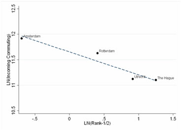
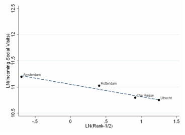
In the 1980s and 1990s, Dutch urbanisation policies focused largely on the development of compact cities. However, more recently, borderless regions, polycentric development, urban networks and overlapping physical infrastructure and social networks have become the central themes in regional and national strategic planning documents, including the draft version of the Vijfde Nota Ruimtelijke Ordening (Fifth Netherlands National Planning Document), the Nota Mobiliteit (Policy Document on Mobility), the Nota Ruimte (National Spatial Strategy) and the AmsterdamStructuurplan (Amsterdam Structure Plan). According to Van der Burg and Dieleman (2002), there were a number of reasons behind this shift in focus from compact cities to urban networks in national urbanisation policies. Amongst other reasons, municipalities and metropolitan areas were seen as being too small to be appropriate units for planning because housing and labour mobility increasingly involved the crossing of local boundaries and because global competition was seen as favouring larger urban areas. As Meijers and Romein (2003) point out, these recent policy documents strongly emphasise regional coordination and cooperation of a sometimes far-reaching nature, in that municipalities that are considered part of an urban network are to develop spatial plans in mutual consultation. A proposal to create a Randstad province that was put forward by a commission led by former Dutch prime minister Wim Kok was recently rejected, and the latest policy document, Structuurvisie Randstad 2040 [Structural Vision Randstad 2040], favours the concentration of the major international functions in the Amsterdam region and the spatial integration of the northern and southern parts of the Randstad separately instead of the integration of the Randstad as a whole. Lambregts et al. (2008) argue that one of the reasons for this change in policy is that it appears to be difficult to build a regional organising capacity in the Randstad and establish voluntary cooperative agreements between the different stakeholders involved. In this situation, efforts at regional coordination and cooperation fail not only because different stakeholders have divergent interests but also because the proponents of a stronger governance at the level of the Randstad cannot convince other stakeholders that it is the appropriate scale for planning and policy-making. A historical account of the Randstad as a spatial-planning concept is beyond the scope of this paper, but Lambregts and Zonneveld (2004) and Lambregts et al. (2008) provide excellent overviews of the subject. Various scholars have also questioned whether the Randstad really constitutes a PUR, as the formation of functional links between the different parts of the Randstad has been limited (e.g., Lambooy, 1998; Ritsema van Eck et al., 2006; Van Oort et al., 2010), and have stressed that having the ambition of creating a polycentric and spatially integrated region does not automatically result in a polycentric and spatially integrated region. A recent OECD report (2007, p. 15) concludes pessimistically that ‘although its morphology as a polycentric metropolitan area gives the Randstad as a whole the opportunity to benefit from the proximity of its several cities and their natural landscapes...these opportunities are currently underused’. One of the problems is that the spatial-planning conceptualisation of the Randstad is predominantly based on its morphological aspects rather than its functional aspects (Healey, 2004; 2006). Although polycentricity and interdependencies between cities are mentioned as important characteristics of the Randstad region, planning documents continue to describe these issues in very abstract terms. They fail to translate the complexity of spatial interdependencies into multiplex, relational spatial representations (Healey, 2004, p. 535) and are at best an ‘uneasy attempt to combine a geography of place with particular qualities and a geography of flows’. In other words, strategic planning for the Randstad often does not take into account the differences in the scope of and appropriate scale of governance for different functional linkages. In this paper, we build on the existing literature by evaluating the different functional relationships between municipalities within the Randstad. The few empirical studies that have analysed PURs in terms of multiplex urban networks (e.g., Lambregts et al., 2005, 2006; Ritsema van Eck et al., 2006) have indicated that the degree to which a region appears to be functionally polycentric depends on the type of functional linkage examined. Similarly, the degree of spatial interdependence between the different subregions varies across functions. For example, Lambregts et al. (2005; 2006) show that although commuting is still restricted to separate subregions, the Randstad constitutes a single area of distribution for companies that provide business services to multinational corporations. At the same time, most of these multinationals are concentrated in Amsterdam, which causes the Randstad to appear fairly monocentric5. DataTo gain insights into the multiplexity of urban networks, we have used three data sources related to 1) daily-activity patterns, 2) intra-firm networks, and 3) inter-firm networks. First, data on activity patterns were obtained from the Mobiliteitsonderzoek Nederland (Dutch National Travel Surveys) for the period of 2004-2008. These data are collected on an annual basis; on average, 50,000 individuals participate in the survey. Of the nearly 550,000 trips in the dataset, which includes geographical information about the origin and destination of the trip, over 130,000 (almost 25%) had as their destination one of the municipalities in the Randstad. Amongst these trips, it is possible to distinguish six types of functional link: journeys to work, journeys to school, business travel, shopping trips, leisure trips, and social visits. Journeys to work can be further subdivided into trips made by working individuals with a high level of educational achievement (ISCED 5-6), those with a moderate level of educational achievement (ISCED 3-4) and those with a low level of educational achievement (ISCED 0-2). By weighting the data to make them representative of the Dutch population as a whole6 and aggregating the data at the municipality level (LAU-2), we were able to construct a multidimensional network of activity patterns for the Randstad. In such networks, a municipality with many incoming connections can be considered central. Second, the data on the 10,000 most important corporations headquartered in the Netherlands and their respective subsidiaries were used to analyse intra-firm relationships. These data were obtained from the Reach and Kamer van Koophandel (Chamber of Commerce) databases, in which headquarters and subsidiary firms are coded by geographic coordinates and economic sectors. We made a further distinction between manufacturing, wholesale distribution and business services, based on the classification of the headquarters. Of the 111,883 subsidiary firms in the database, 63,624 (56.9%) are owned by firms whose headquarters are located in one of the 69 Randstad municipalities. By aggregating the data at the municipality level, the relative importance of cities and towns can be assessed within corporate networks. In this analysis, the degree of centrality of a municipality in the urban network was determined based on the number of subsidiary firms (i.e., connections) that corporations headquartered in that municipality have. This can be considered to be a measure of the level of ownership that companies in a particular city have of firms in other cities; a municipality with many incoming subsidiary-headquarters connections has considerable control over other municipalities and is, therefore, central in the urban network. A more detailed description of how this type of data analysis is constructed can be found in Wall (2009) and Wall and Van der Knaap (2011). Third, data on inter-firm relationships in the Randstad were obtained from the survey by Van Oort et al. (2010) of companies based in the Randstad, in which the companies were asked to indicate the main sources and destinations of their most important selling and purchasing activities. The data were gathered in a 2005 survey of more than 20,000 firms in manufacturing, wholesale, and commercial services that had more than one employee based in the Randstad (Van Oort et al., 2010). The 1,676 companies that responded to the survey (8%) were representative in terms of their regional distribution and stratification by firm size7. The data were aggregated at the municipality level. A municipality with many connections in terms of the total number of selling and purchasing relationships can be considered central8. Quantifying the Spatial Organisation of the PURAlthough the spatial organisation of the PUR has many facets and networks can be compared in many ways, we focus here on two particular aspects of that organisation: functional polycentricity and spatial interdependencies. The degree of functional polycentricity is determined by the balance in the importance of the region’s urban centres in terms of their centrality within the urban network. In our analysis, centrality scores are based on the number of incoming functional linkages (e.g., the number of incoming commuters), excluding intra-municipality linkages. When the urban centres in the Randstad’s network are more equal in importance, the region is more functionally polycentric. To assess the distribution of the importance of urban centres within the Randstad region in terms of the different types of functional linkage, we used the commonly used ordinary-least-squares log-log rank-size regression method (see also Meijers, 2008; Burger and Meijers, 2012). The major indicator is the slope of the regression line that best fits these rank-size distributions, which ranges between 0 (completely polycentric) and , where a slope of -1 is typically associated with the presence of a monocentric urban system. In other words, a flatter downward slope of the regression line indicates a more functionally polycentric region. In contrast, a steeper downward slope of the regression line indicates a more functionally monocentric region9. In comparing different types of functional linkage, it is best to base the rank-size regressions on a fixed number of centres (see also Meijers, 2008; Burger and Meijers, 2012). In our analysis, we treated the Randstad as a closed system (always using the same set of 69 municipalities) and estimated the coefficients for the four and ten most-central municipalities. As an example, Figure 3 shows the rank-size distributions (including the 95% confidence intervals) of the four most-central municipalities in the Randstad in terms of incoming commuting and social visits. As can be seen in the graphs, the rank-size distributions can differ considerably across types of functional linkage; in this example, incoming social visits give a more polycentric picture of the Randstad than incoming commutes. Figure 3: Rank-size Distributions Measuring Monocentricityversus Polycentricity for Two Types of Functional Linkages (A) Commuting
(B) Social Visits
Following previous research (Burger et al., 2011; Burger and Meijers, 2012), we measured the degree of interdependence between cities by evaluating network density. Network density can be conceptualised as the ratio of the number of actual connections between centres to the number of potential connections between centres (Green, 2007). In this study, we investigated two aspects, namely the internal network density and the overall network density, of the Randstad. The internal network density is a measurement of the number of connections between the municipalities in the Randstad as a proportion of the total number of connections originating from the municipalities in the Randstad and reflects the relative importance of the other Randstad sub-regions compared to the own subregions. The overall network density is a measurement of the connections between municipalities in different subregions of the Randstad as a percentage of the total number of connections. For both of these indicators, a low score indicates a low degree of spatial interdependence. Polycentricity, Integration and the Multiplexity of Urban NetworksGeographical Scope and Overlap amongst Urban NetworksTable 2 gives an overview of the geographical scope of different functional linkages targeted at municipalities in the Randstad. To determine the scope of each type of link, we distinguished between linkages originating from 1) the same municipality, 2) other municipalities in the same subregion, 3) other municipalities in the Randstad, 4) other municipalities in the Netherlands, and 5) locations outside the Netherlands10. The data in Table 2 show that the geographical scope of the spatial interaction varies from very local (for shopping and education) to predominantly international (subsidiary-headquarters relationships). More than 80% of all journeys to school and shopping trips whose destination is a municipality in the Randstad originate within the same subregion. In contrast, only one out of six subsidiary-headquarters relationships are within the same subregion. Relative to other types of functional linkages, there appears to be a significant degree of network formation with respect to inter-firm relationships, in the form of buyer-supplier relationships and business travel. However, it should be noted that, even for these latter types of spatial interaction, connections within the same subregion are more numerous than those with municipalities in other subregions of the Randstad (see also Van Oort et al., 2010). Table 2: Geographical Scope of Different Functional Links Targeted at Municipalities in the Randstad
In the analysis of commuting patterns, significant differences were found in the geographical scope of the labour-market areas for more highly educated individuals and less-well-educated individuals. Whereas less than 25% of the less-well-educated working population live in a different subregion from the one they work in, nearly 45% of the more highly educated working population does so (within the latter group, about 20% come from elsewhere in the Randstad and the other 25% come from outside the Randstad, most often from the bordering municipalities). This finding confirms the results of previous research on Dutch travel behaviour, which has shown that individuals of a higher socioeconomic status are more likely to engage in long-distance travel (Van Ham, 2002; Limtanakool et al., 2006). In addition, it signifies that commuting patterns (and perhaps also other types of functional linkage) are far from homogeneous and that complexity should be taken into account when examining spatial-interaction data11. Indeed, as Meijers and Romein (2003) have suggested, the Randstad may function more like a PUR for some particular subparts of the population. Functional Polycentricity and Network DensityHaving examined the geographical scope of the different functional linkages analysed, we now turn our attention to the two most important aspects of the PUR: the degrees of functional polycentricity and spatial interdependence. As a benchmark, we also estimated the degree of morphological polycentricity, based on total number of inhabitants and firm establishments, using a similar rank-size regression method. The rather high coefficients (close to zero) for the rank-size regressions of the four largest urban centres (Amsterdam, Rotterdam, The Hague and Utrecht) for population (-0.31) and employment (-0.42) indicate that the Randstad is morphologically a fairly polycentric region. In our analysis of functional polycentricity, we found that the coefficients of the rank-size regressions for the ten most functionally polycentric largest urban centres are slightly more unevenly distributed than the rank-size regressions for the four most functionally polycentric centres (see Table 3, Columns 1 and 2). This finding highlights that the Randstad is polycentric at the inter-urban level but consists of four rather monocentric subregions (see also Van Oort et al., 2010; Burger and Meijers, 2012). With regard to the differences between types of functional linkage, especially inter-municipal shopping and social visits, the connections appear to be multidirectional, having relatively very low rank-size coefficients. In contrast with inter-municipal shopping and social visits, the rank-size coefficients for population (-0.31 for the four largest centres) and employment (-0.42 for the four largest centres) show that those morphological features are less evenly distributed in the Randstad. The patterns of inter-municipal business travel and buyer-supplier relationships are also quite polycentric. In contrast, the distribution of subsidiary-headquarters links (i.e., of corporate-control functions) is relatively skewed, especially with respect to business services, in that a disproportionate share of these relationships involve headquarters in the Amsterdam region (see Table 3, Column 3). Our analysis confirms the results of previous studies by Lambregts et al. (2005; 2006) and Wall (2009), who found that Amsterdam is the only truly global city in the Randstad. In fact, if we had limited our sample to the top 100 Dutch companies or performed analyses on the top 100 European or global companies, an even more monocentric pattern would likely have emerged with Amsterdam firmly positioned at the top of the Randstad hierarchy (see Wall, 2009). We found a similar pattern when we analysed only the concentration of incoming subsidiary-headquarters links in the Amsterdam region, which is the most central region with respect to all of the functional linkages under consideration (see Table 3, Column 3). The degree of spatial interdependence (see Table 3, Columns 4 and 5) corresponds closely with the geographical scope of different types of functional linkage described in the previous section; the degree of spatial interdependence in the Randstad region is also function-dependent. Table 3: Degrees of Functional Polycentricity and Spatial Integration Based on Functional Linkages
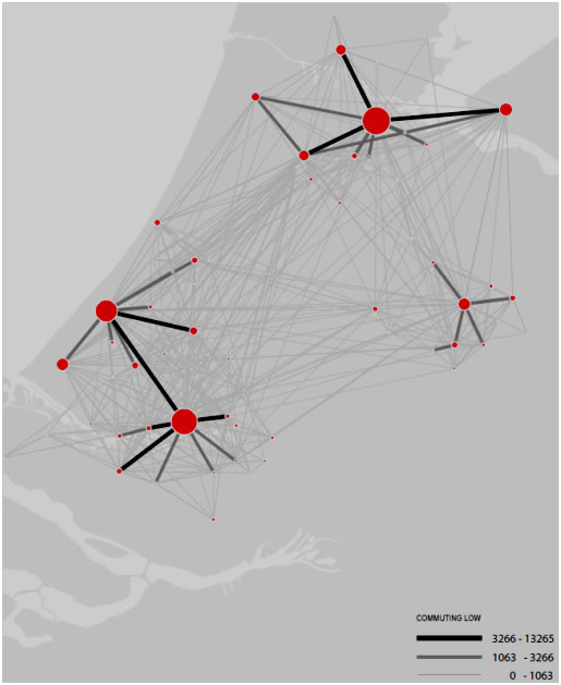
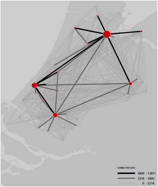
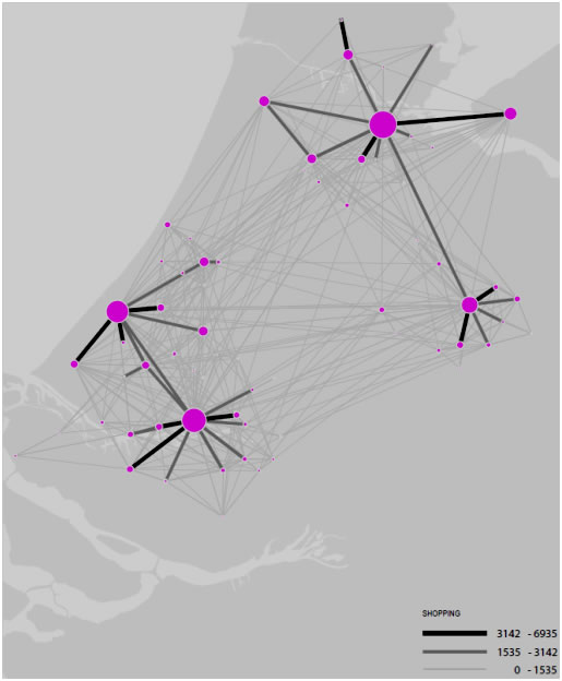
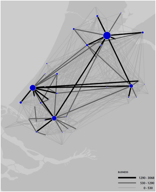
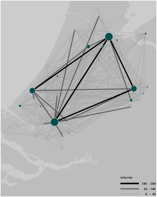
Figures 4-8, depicting the strength of urban network formation, illustrate the differences between different types of flows. Whereas the size of the node indicates the centrality of a city in the network, the thickness of the lines indicates the strength of urban network formation between two cities in terms of the relative number of travellers (commuters or business travellers) or firm relationships (buyer-seller or headquarter-subsidiary relationships). Given the aforementioned problems with delimiting the boundaries of the Randstad, the level of network formation with respect to the commuting patterns of the highly educated working population, business travel, intra-firm relationships and inter-firm relationships can be considered to be moderately high. This finding is broadly in line with the work of Lambregts et al. (2005; 2006), who found that the Randstad constitutes a single area of distribution for firms that provide business services to multinational corporations. On the other hand, other flows, such as commuting of the less-well-educated workforce, shopping and journeys to school remain relatively local. Figure 4: Commuting of Less-Well-Educated Workforce in the Randstad
Figure 5: Commuting of Highly-Educated Workforce in the Randstad
Figure 6: Shopping in the Randstad
Figure 7: Business Travel in the Randstad
Figure 8: Intra-Firm Relations in the Randstad
Discussion and ConclusionsIn this paper, we have examined the multiplexity of urban networks within the context of the PUR. The analyses of commuting, journeys to school, business travel, shopping-related travel, trade and investment flows in the Dutch Randstad have highlighted different aspects of the relational complexity of that PUR. Although the Randstad is undeniably polycentric from a morphological point of view (at least in comparison with similarly-sized regions across the world), it is not necessarily polycentric from a functional point of view, in that Amsterdam can be considered its only truly global city (see also Lambregts et al., 2005; 2006 and Wall, 2009). In addition, the degree of interdependence between the different parts of the Randstad appears to be limited; this observation echoes the findings of other studies on PURs. This does not mean that functional relationships at the level of the Randstad do not exist. The level of network formation with respect to the commuting patterns of the highly educated working population, business travel, intra-firm relationships and inter-firm relationships can be considered to be moderately high. Although these relations are less numerous, they are not by any means economically insignificant. Further research, including a more formal, econometrics-based testing framework (see, for example, De Goei et al., 2010; Van Oort et al., 2010; Champion and Coombes, 2012; Hanssens et al., 2012) is needed to confirm our findings with regard to the spatial organisation of the Randstad. Although the Randstad does not (yet) function as a spatially urban network, the potential seems to exist for organising particular functions at a higher level of governance than that of the individual subregions and especially for organising these functions between the four larger cities (see also Van Oort et al., 2010). However, for very local functions such as retail and education, PURs in general and the Randstad in particular might not be the appropriate level at which to formulate and implement spatial planning policies. Albrechts (2001, p. 743) rightly points out that ‘only when the issue at stake surpasses the capacity of the individual cities and a win-win situation can be provided, may cities be willing to consider delegating parts of their competence to another authority’. At the same time, the local focus of these daily activity patterns could be at the root of one of the basic problems in generating support for governance in the Randstad. As the most visible functional relationships are the most local ones (see also Lambregts et al., 2008), this makes it more difficult for proponents of a stronger governance at the level of the Randstad to convince other stakeholders that it is the appropriate scale for planning and policy-making. However, and especially in the light of the fragility of the Randstad cooperation lately, explaining the success and failure of coordinated regional planning is more complex. Other factors, such as divergent interests, the existing hierarchical and power relationships within a PUR, and the revealed challenges and opportunities that are imposed by the outside world, may play an important role in building organising capacity. Future research on regional integrated policies should examine the relative importance of these factors in fostering and discouraging regional cooperation and governance. ACKNOWLEDGEMENTSWe would like to thank two anonymous reviewers for their comments on an earlier draft of this paper. All errors remain the authors’. REFERENCESALBRECHTS, L. (2001) How to proceed from Image and discourse to action: as applied to the Flemish Diamond, Urban Studies, 38, pp. 733-745. ALBRECHTS, L. (2004) Spatial (strategic) planning reexamined, Environment and Planning B: Planning and Design, 31, pp. 743-758. ALBRECHTS, L., HEALEY, P. and KUNZMANN, K.R. (2003) Strategic spatial planning and regional governance in Europe, Journal of the American Planning Association, 69, pp. 113-129. BAILEY, N. and TUROK, I. (2001) Central Scotland and polycentric urban region: useful planning concept or Chimera?, Urban Studies, 38, pp. 697-715. BODE, E., Delineating metropolitan areas using land prices, Journal of Regional Science 48, pp. 131-163. BROWN, L.A. and HOLMES, J. (1971) The delimitation of functional regions, nodal regions and hierarchies by functional distance approaches, Journal of Regional Science, 11, 57-72. BURGER, M.J., DE GOEI, B., VAN DER LAAN, L. and HUISMAN F.M.J. (2011) Heterogeneous development of metropolitan spatial structure: evidence from commuting patterns in English and Welsh city-regions, Cities, 28, pp. 160-170. BURGER, M. and MEIJERS, E. (2012) Form follows function? Linking functional and morphological polycentricity, Urban Studies, 49, pp. 1127-1149. CHAMPION, A.G. (2001) A changing demographic regime and evolving polycentric urban regions: consequences for the size, composition and distribution of city populations, Urban Studies, 37, pp. 657-677. CHAMPION, T. and COOMBES, M. (2012) Is Pennine England becoming more polycentric or more centripetal? An analysis of commuting flow in a transforming industrial region, 1981-2001. SERC Discussion Paper 105. CHRISTALLER, W. (1933) Die Zentralen Orte in Süddeutschland. Jena: Gustav Fischer. COOMBES, M.G. and WYMER, C. (2001) A new approach to identifying localities: representing ‘places’ in Britain. In: Medanipour, A., Hull, A. and Healey, P. (eds) The Governance of Place: Space and Planning Processes, pp. 51-69. Aldershot: Ashgate. DAVOUDI, S. (2003) Polycentricity in European spatial planning: from an analytical tool to a normative agenda? European Planning Studies, 11, pp. 979-999. DAVOUDI, S. (2008) Conceptions of the city-region: a critical review, Urban Design and Planning, 16, pp. 51-60. DIELEMAN, F.M., FALUDI, A. (1998) Polynucleated metropolitan regions in northwest Europe: theme of the special issue, European Planning Studies, 6, pp. 365-378. DE GOEI, B., BURGER, M.J., VAN OORT, F.G. and KITSON, M. (2010) Functional polycentrism and urban network development in the Greater South East, United Kingdom: Evidence from Commuting Networks, 1981-2001, Regional Studies, 44, pp. 1149-1170. DIJST, M.J. and VIDAKOVIC, V. (2000) Travel time ratio: the key factor of spatial reach, Transportation, 27, pp. 179-199. FALUDI (2004) Spatial planning traditions in Europe: their role in the ESDP process, International Planning Studies, 9, pp. 155-172. GABAIX, X. and IBRAGIMOV, R. (2011) Rank-1/2: a simple way to improve the OLS estimation of tail exponents, Journal of Business Economics andStatistics,29, pp. 24-39. GREEN, N. (2007) Functional polycentricity: a formal definition in terms of social network analysis, Urban Studies, 44, pp. 2077-2103. HÄGERSTRAND, T. (1970) What about people in regional science?, Papers in Regional Science, 24, pp. 7-21. HALBERT, L. (2008) Examining the Mega-City-Region hypothesis: evidence from the Paris City-Region / Bassin parisien,Regional Studies, 42, pp. 1147-1160. HALL, P. (1966) The World Cities. London: Weidenfield and Nicolson. HALL, P. and PAIN, K. (2006) (Eds) The Polycentric Metropolis: Learning from Mega-City Regions in Europe. London: Earthscan. HANSSENS, H., DERUDDER, B., VAN AELST, S. and WITLOX, F. (2012), Assessing functional polycentricity of the mega-city region of Central Belgium based on advanced producer service transaction links. Regional Studies (forthcoming). HEALEY, P. (2004) The treatment of space and place in the new strategic spatial planning Europe, International Journal of Urban and Regional Research, 28, pp. 45-67. HEALEY, P. (2006) Relational complexity and the imaginative power of strategic spatial planning, European Planning Studies, 14, pp. 525-546. HEWINGS and PARR (2007) Spatial interdependence in a metropolitan setting, Spatial Economic Analysis, 2, pp. 7-22. HOYLER, M., KLOOSTERMAN, R.C. and SOKOL, M. (2008) Polycentric puzzles – emerging mega-city regions seen through the lens of advanced producer services, Regional Studies, 42, 1055-1064. KLOOSTERMAN, R.C. and MUSTERD, S. (2001) The polycentric urban region: towards a research agenda, Urban Studies, 38, pp. 623-633 LAMBOOY, J.G. (1998) Polynucleation and urban development: the Randstad, European Planning Studies, 6, pp. 457-467. LAMBREGTS, B. (2009) The Polycentric Metropolis Unpacked: Concepts, Trends and Policy in the Randstad Holland. Amsterdam: Amsterdam Institute for Metropolitan and International Development Studies. LAMBREGTS, B., JANSSEN-JANSEN, L. and HARAN, N. (2008) Effective governance for competitive regions in Europe: the difficult case of the Randstad, GeoJournal, 72, pp. 45-57. LAMBREGTS, B., KLOOSTERMAN, R.C., VAN DER WERFF, M. (2005) Polycentricity and the eye of the beholder: a multi-layered analysis of spatial patterns in the Dutch Randstad, Romanian Economic Journal, 8, pp. 19-34. LAMBREGTS, B., KLOOSTERMAN, R., VAN DER WERFF, M., ROLING, R. and KAPOEN, L. (2006) Randstad Holland: multiple faces of a polycentric role model, in P. HALL and K. PAIN (Eds) The Polycentric Metropolis. Learning from Mega-City Regions in Europe, pp. 137-145. London: Earthscan. LAMBREGTS, B. and ZONNEVELD, W. (2004) From Randstad to Deltametropolis: changing attitudes towards the scattered metropolis, European Planning Studies, 12, pp. 299-323. LEE, B. and GORDON, P. (2007) Urban spatial structure and economic growth in US metropolitan areas. Paper presented at the 46th annual meeting of the Western Regional Science Association, Newport Beach, CA. LIMTANAKOOL, N., DIJST, M., SCHWANEN, T. (2006) On the participation in medium- and long-distance travel: a decomposition analysis for the UK and the Netherlands, Tijdschrift voor Economische en Sociale Geografie, 97, pp. 389-404. LIMTANAKOOL N., SCHWANEN T. and DIJST M. (2009) Developments in the Dutch urban system on the basis of flows, Regional Studies, 43, pp. 179-196. LÖSCH, A. (1944) Die Räumliche Ordnung der Wirtschaft. Jena: Gustav Fischer. LÜHTI, S., THIERSTEIN, A. and GOEBEL, V. (2010) Intra-firm and extra-firm linkages in the knowledge economy: the case of the emerging mega-city region of Munich, Global Networks, 10, pp. 114-137. MASSER, I. (1972), Analytical Models for Urban and Regional Planning. Newton Abbott: David & Charles. MEIJERS, E. (2005) Polycentric urban regions and the quest for synergy: is a network of cities more than the sum of its parts? Urban Studies, 42, pp. 765-781. MEIJERS, E. (2008) Measuring polycentricity and its promises, European Planning Studies, 16, 1313-1323. MEIJERS, E. and BURGER, M. (2010) Spatial structure and productivity in US metropolitan areas, Environment and Planning A, 42, pp. 1383-1402. MEIJERS, E. and ROMEIN, A. (2003) Realizing potential: building regional organizing capacity in polycentric urban regions, European Urban and Regional Studies, 10, pp. 173-186. MEIJERS, E., HOEKSTRA, J. and AGUADO, R. (2008) Strategic planning for city networks: the emergence of a Basque global city?, International Planning Studies, 13, pp. 239-259. MEIJERS, E.J., WATERHOUT, B. and ZONNEVELD, W.A.M. (2007) Closing the gap: territorial cohesion through polycentric development, European Journal of Spatial Development, 24, October 2007. PARR, J.B. (2004) The polycentric urban region: a closer inspection, Regional Studies, 38, pp. 231-240. PARR, J.B. (2005) Perspectives on the city-region, Regional Studies, 39, pp. 555-566. RITSEMA VAN ECK, J., VAN OORT, F.G., RASPE, O., DAALHUIZEN, F. and VAN BRUSSEL, J. (2006) Vele steden maken nog geen Randstad. Rotterdam/Den Haag: NAi Uitgevers. ROBSON, B., BARR, R., LYMPEROPOULO, K. RESS, J. and COOMBES, M.G. (2006) A Framework for City Regions – Working Paper 1: Mapping City-Regions. London: Office of the Deputy Prime Minister, London. THRIFT, N. (1977) An Introduction to Time Geography. Norwich: Geo Abstracts. TUROK, I. and BAILEY, N. (2004) The theory of polynuclear urban regions and its application to Central Scotland, European Planning Studies, 12, 373-389. VAN DER BURG, A.J. and DIELEMAN, F.M. (2002) Dutch urbanization policies: from ‘compact city’ to ‘urban network’, Tijdschrift voor Economische en Sociale Geografie, 95, pp. 108-116. VAN DER KNAAP, G.A. (2007) Urban network formation under conditions of uncertainty in P.J. TAYLOR, B. DERUDDER, P. SAEY and F. WITLOX (Eds) Cities in Globalization: Practices, Policies and Theories, pp. 84-101. London: Routledge. VAN HAM, M. (2002) Job Access, Workplace Mobility, and Occupational Achievement. Delft: Eburon Publishers. VAN HOUTUM, H. and LAGENDIJK, A. (2001), Contextualising regional identity and imagination in the construction of Polycentric Urban Regions: the cases of the Ruhr Area and the Basque Country, Urban Studies, 38, pp. 747-767. VAN OORT, F.G. (2007) Spatial and sectoral composition effects of agglomeration economies in the Netherlands, Papers in Regional Science, 86, pp. 5-30. VAN OORT, F., BURGER, M., RASPE, O. (2010) On the economic foundation of the urban network paradigm. Spatial integration, functional integration and complementarities within the Dutch Randstad, Urban Studies, 47, pp. 725-748. VASANEN, A. (2012) Functional polycentricity: examining metropolitan spatial structure through the connectivity of urban sub-centres, Urban Studies (forthcoming). VENERI, P. and BURGALASSI, D. (2012) Questioning polycentric development and its effects. Issues of definition and measurement for the Italian NUTS-2 regions, European Planning Studies, 20, 1017-1037. WALL, R.S. (2009) The relative importance of Randstad cities within comparative worldwide corporate networks, Tijdschrift voor Economische en Sociale Geografie 100, pp. 250-259. WALL, R.S., VAN DER KNAAP, G.A. (2011) Function and hierarchy within contemporary worldwide corporate networks, Economic Geography 87, pp. 267-308. WATERHOUT, B. (2002) Polycentric development: what is behind it?, in A.FALUDI (Ed.), European Spatial Planning, pp. 83-103. Cambridge, MA: Lincoln Institute of Land Policy.
NOTES* Martijn J. Burger, Corresponding author: Department of Applied Economics, Erasmus University Rotterdam, Tinbergen Institute and Erasmus Research Institute for Management (ERIM), E-mail: mburger@ese.eur.nl ** Bert van der Knaap, Department of Applied Economics, Erasmus University Rotterdam. E-mail: vanderknaap@ese.eur.nl *** Ronald S. Wall, Institute for Housing and Urban Studies, Erasmus University Rotterdam. E-mail: wall@ihs.nl 1. At the same time, evidence that a polycentric region was functionally integrated would also support planning on larger geographical scales than that of the city or region in question to manage those spatial interdependencies (Turok and Bailey, 2004). 2. This has been demonstrated empirically by, for example, Lambregts et al. (2005; 2006), whose analyses of commuting patterns, intra-company office networks and inter-company business-services networks give very different pictures of the spatial organisation of the Randstad region in Holland. Similar conclusions can be drawn with regard to other regions based on the work of Limtanakool et al. (2009) and Lüthi et al. (2010). 3. As Davoudi (2008) points out, this has also resulted in the dominance of an economics-based conceptualisation of functional regions. 4. Similarly, an urban system may have a predominantly polycentric structure at the regional level and a predominantly monocentric structure at the local level or vice versa. For example, commuting, trade and shopping could be multidirectional at the level of the PUR but unidirectional at the level of the individual metropolitan areas (see also De Goei et al., 2010). 5. Lüthi et al. (2010: 114) observe a similar pattern in the Munich region, which they classify as ‘a hierarchically organized polycentric mega-city region and high-grade localized system of value chains’. 6. The weighting factors were included in the data as analysed. 7. A random, stratified sample, taking size and region into account, was extracted from the LISA database, which is an employment register including all Dutch establishments (see Van Oort, 2007). The survey focused on companies’ ten most important selling and purchasing relationships with other establishments within or outside of their own municipality. The limitation of the data to ten relationships may lead to a potential bias in the analysis of the network structure towards large establishments, but large establishments are not overrepresented in cities in the Randstad (Van Oort et al., 2010). We were not able to analyse the different sectors separately. 8. Because of the limitations of the data, we are not able to distinguish between incoming and outgoing connections in this case. 9. We used the specification of Gabaix and Ibragimov (2011) to estimate the coefficients. 10. It should be noted that these distinctions depend on our definition of the Randstad. A large number of trips that we analyse as having originated outside the Randstad in fact originated in urban centres that are in close proximity to the Randstad but are not part of the Randstad according to our delimitation. Because we are mainly interested in comparing different types of functional linkage and are focusing on the polycentricity and integration of the four largest urban centres in the region, this delimitation is appropriate. However, this caveat underlines that the definition of the boundaries of functional regions is heavily dependent on the functional relationship under consideration (see also, Brown and Holmes, 1971). 11. However, it is often difficult to obtain such detailed, broken-down data for functions of interest. For example, it is well known from the central-place literature that most inter-regional shopping trips are for purchases of luxury goods rather than daily shopping goods (Dijst and Vidakovic, 2000). Although these trips represent different types of functional linkage, it is most often not possible to make such distinction in the analysis of data on shopping trips.
|
|||||||||||||||||||||||||||||||||||||||||||||||||||||||||||||||||||||||||||||||||||||||||||||||||||||||||||||||||||||||||||||||||||||||||||||||||||||||||||||||||||||||||||||||||||||||||||||||||||||||||||||||||||||||||||||||||||||||||||