GaWC Research Bulletin 382 |
|
|
|
This Research Bulletin has been published in Environment and Planning A, 43 (10), (2011), 2255-2256. doi:10.1068/a44135 Please refer to the published version when quoting the paper.
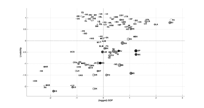
We combine information on four different indicators to assess cities' social, economic, and environmental characteristics in a global context: Gross Domestic Product (GDP) which reflects cities' economic competitiveness; livability measures focusing on cities' social issues such as safety, education and health; income inequality of the country within which individual cities locate; and urban populations. Based on the data availability in these four datasets, a total of ninety-eight cities across the world are presented in this graphic. Cities' standardized, logged GDP values are plotted on the X-axis, against their standardized livability measurements on the Y-axis. Data points represent individual cities and their sizes are proportional to cities' populations. Darker colors of data points represent greater income inequality, and vice versa. Centering at the coordinate origin, the plot is divided into four quadrants. These four quadrants on the scatter plot classify cities' differential characteristics. Upper right quadrant: Cities with above-average values in both dimensions are at the top of the global urban hierarchy, with relatively large populations, high-quality livability, and high GDP. Lower right quadrant: In this quadrant lie leading cities from the erstwhile 'Third World', which show greater national income inequality, host large populations, and have a comparatively low quality of life. Upper left quadrant: Cities in this category are primarily located in welfare states. Lower left quadrant: African cities dominate in this category, and are usually deemed as backwaters in the increasingly integrated world economy.
Figure 1: Featured graphic
NOTES* Xingjian Liu, University of Cambridge,Cambridge, UK, email: xl306@cam.ac.uk ** Ben Derudder, Department of Geography, Ghent University, Belgium, email: ben.derudder@ugent.be *** Yaolin Liu, Wuhan University, China
Note: This Research Bulletin has been published in Environment and Planning A, 43 (10), (2011), 2255-2256 |
||