GaWC Research Bulletin 367 |
|
|
|
This Research Bulletin has been published in Cities, 28 (2), (2011), 160-170. doi:10.1016/j.cities.2010.11.006 Please refer to the published version when quoting the paper.
IntroductionIn the contemporary literature on urban systems, it is often argued that polycentricity has become the dominant metropolitan form in Western-Europe. It is claimed that the monocentric model in which a principal city offers labour demand and the surrounding territory labour supply, is increasingly inaccurate (Meijers, 2007). Indeed, it is hypothesised that firms and households increasingly locate outside the principal city create new centres while maintaining significant linkages with the original core. In addition, it is conjectured that a spatial and functional integration of proximate but historically autonomous urban centres within the same city-region is taking place.1 The outcome of these developments is hypothesised to be a spatially and functionally integrated city-region with multiple centres at the supra-local scale. Therefore, it is argued that modern urban life is not longer taking place in a monocentric city but in a polycentric city-region. In this, the emphasis on polycentricity reflects the move from a territory dominated by one principal centre to a territory in which no centre dominates the other centres (Kloosterman and Musterd, 2001; Meijers, 2007). The emphasis on the city-region indicates a shift from the principal city and its suburbs as unit of analysis, to the principal city and its wider surrounding territory (Parr, 2005; Davoudi, 2008). The changes in the relationship between cities and their surrounding territory are often seen as consequences of economic and socio-cultural developments. Examples of such developments are the changes in the demography of Western populations, the change of Western economies from being dominated by manufacturing to services, and an increased demand for customised products and services (Champion, 2001; De Goei et al., 2010). At the same time, increasing urban diseconomies such as congestion, high land prices and pollution is making the principal city increasingly unattractive (Richardson, 1995). These developments have resulted in complex and interlinked processes of deconcentration and restructuring (Champion, 2001). Some scholars argue that the size of the population and firms residing in the core is dependent on the stage of urban development (Van der Berg et al., 1982; Tosics, 2004). Others perceive the development of spatial structure as a path-dependent process, in which spatial structure is predominantly determined by how cities and urban systems were initially shaped (see e.g., Nitsch, 2003; Kloosterman and Lambregts, 2007). The focal point in all these discussions is a clear view on the development of spatial structures. Many past empirical studies on urban systems were cross-sectional and as such assess spatial structure at only one specific point in time. More recently, scholars have focussed on modelling the dynamics of metropolitan spatial structures (see e.g., Aguilera and Mignot, 2004; Nielsen and Hovgesen, 2005; Green, 2008; Guth et al., 2009; De Goei et al., 2010). There is a great amount of literature on the emergence of the polycentric city-region (e.g. Kloosterman and Musterd, 2001; Parr, 2005), including an increasing number of empirical studies on polycentric development. However, two elements in this field of research have remained underexposed to some extent. First, with regards to spatial heterogeneity in urban development processes, many studies assume, often implicitly, that urban systems evolve from a monocentric spatial structure towards some form of polycentric spatial structure. However, the original state differs between city-regions. Some city-regions are predominantly monocentric; others are predominantly polycentric. In reality, most city-regions will be somewhere in between (De Goei et al., 2010). As such, in a dynamic point of view, the spatial structure of city-regions does not necessarily have to change in the same direction.2 Secondly, it is often neglected that polycentricity may take different forms. Patterns of deconcentration can differ across urban systems, ranging from the presence of exchange commuting between the original centre and the surrounding territory to a fully networked city-region. In the latter city-region the original centre and surrounding territory have become indistinct (Van der Laan, 1998; Schwanen et al., 2003). This article aims to contribute to the existing literature on metropolitan spatial structure by analysing the development of city-regions at the supra-local scale. Traditionally, metropolitan spatial structure has been assessed by looking at the distribution of internal characteristics of cities such as the number of residents or jobs. However, many of the theoretical foundations for the polycentric model are based on flows linked to the physical movement of goods, people and services (Hall, 2001; De Goei et al., 2010). Also, the importance of centres is increasingly determined by their position in a network of cities (Batten, 1995; Hall, 2001). Hence, the metropolitan spatial structure is not only assessed by looking at the distribution of population or employment within a city-region, but by looking at the distribution of flows between the different parts of the city-region. As such, a typology of city-regions is developed based on the spatial configuration of commuting networks (Van der Laan, 1998; Schwanen et al., 2003). To accomplish this, a number of related features of urban systems need to be taken into account. Such factors include the network density – or the degree of functional integration of the different parts of the city-region – and the openness of city-regions. This article uses data on journey-to-work travel in 22 city-regions in England and Wales for the period 1981-2001. Employment and commuting patterns are a useful source for investigating the development of metropolitan structure because labour market interactions between centres constitute the majority of all daily trips within city-regions (Clark and Kuijpers-Linde, 1994). In addition, commuting data is still the most elaborate, reliable, and relevant interaction data available. This paper addresses the heterogeneity in metropolitan spatial structure present in the English and Welsh urban system by comparing the spatial structures of city-regions over time. The remainder of this article is organised as follows. The next two sections contain a discussion on the literature on changing urban systems. In particular, the focus is here on the level of the city-region (supra-local scale). As such, the current trend towards mega-city regions (Hall and Pain, 2006; Hoyler et al., 2008) at a higher geographical scale is beyond the scope of this article. In Section 4, the dataset and research methods are introduced. Section 5 contains an overview of the main empirical results, followed by a discussion and conclusion in Section 6. From a Monocentric City to a Polycentric City-RegionFrom Cities to City-RegionsIn academics and policy, the debate on urban development has shifted from the city to the city-region as primary unit of analysis (Parr, 2005; 2008; Davoudi, 2008). As indicated by Parr (2008, p. 3017) this increasing interest in the city-region as unit of analysis echoes ‘a growing appreciation that in certain important respects the city is not a satisfactory unit of analysis, since many of its external interaction are with adjacent (and sometimes extensive) areas’.3 Although there are multiple spatial imaginations of the city-region such as specific administrative units or NUTS-2 areas (Parr, 2005), this research takes the perspective of city-regions as functional urban regions. Embedded in urban systems theory, cities and their surroundings are herein perceived as functionally interdependent entities linked through economic flows such as inter-firm trade, labour market interactions, and shopping (Berry, 1964; Parr, 1987). In this, the dominant flows determine the delineation of city-regions (Davoudi, 2008). The city-region is usually perceived as a principal city and a territory surrounding this principal city (Parr, 2005; 2008). This surrounding territory does not only consist of suburban areas, but also of rural villages and, most importantly, subordinate urban centres. These different parts of the city-region form together a functional economic space (Davoudi, 2008).4 From Monocentric to Polycentric City-RegionsThe study of metropolitan spatial structure of originates from urban location theory and can be traced back to the theoretical work by Alonso (1964) on the monocentric model, which was adapted from the work of Christaller (1933) on hierarchical urban systems. From a morphological point of view, the monocentric model predicts a strict division of labor between the Central Business District (CBD) and suburban areas, where the CBD takes care of the labor demand and the suburbs of the labor supply. In other words, the size distribution of centres in terms of employment is highly unbalanced in a monocentric city. From a functional point of view, the monocentric spatial system is then best represented by a star-shaped pattern of interactions, where the journey-to-work flows are all directed from the suburbs to the CBD (Haggett and Chorley, 1967). As indicated by Parr (2008), the monocentric city model can be perceived as a special case of the traditional Löschian city-region (Lösch, 1944). Like the monocentric city, the traditional city-region is perceived as a nodal area, in which the principal city is characterised by a deficit labour supply and the territory surrounding the principal city by a deficit labour demand (Parr, 1987; 2005). Accordingly, journey-to-work flows are directed from the surrounding territory to the principal city. The monocentric model was challenged from two sides (Van der Laan et al., 1998). First, the model was unable to explain the emergence of employment locations in the suburbs, and hence the emergence of sub-centres (Garreau, 1991). Likewise, at the level of the city-region the monocentric model has been unable to explain a shift in employment from the principal centre to the subordinate centres in the surrounding territory and the resultant decrease of commuting from the surrounding territory to the principal city. Second, the existence of an enormous amount of 'excess' or ‘wasteful’ commuting – the difference between the average commuting distance projected by the monocentric density function based on travel-minimising behaviour and the actual required commuting distance – made the monocentric model unrealistic (Small and Song, 1994). The most obvious reason for the ‘failure’ of the monocentric model is the increasing percentage of journey-to-work travels from the principal city to the surrounding territory and between different parts of the surrounding territory.5 Whereas the monocentric concept gave way to that of polycentric city-regions, the actual resultant metropolitan spatial structure remains often unclear (Van der Laan, 1998).6 For example, a polycentric city-region can be characterised by a spatial structure whereby only exchange commuting between the original centre and the surrounding territory is present or by a more fragmented pattern in which the original principal city and subordinate centres has become indistinct. A more elaborate discussion of these issues is provided in the next section. Metropolitan Spatial StructureConceptualizing the Importance of CentresEvery assessment of spatial structure starts off within determining the importance of centres. As indicated by Preston (1971), one can make here a distinction between the absolute importance of a centre or its nodality and the relative importance of a centre or its centrality. In the light of employment and journey-to-work flows, the nodality of a centre can be expressed by the total number of jobs it provides, whereas the centrality of a centre can be defined as the part of its importance that can be ascribed to jobs in excess of those demanded by the centre’s own inhabitants. The distinction between nodality and centrality can be traced back to the work by Christaller (1933), who argued that if the importance of a centre was determined solely on the basis of its size, then part of its importance must be ascribed to the settlement itself as an agglomeration and another part to the settlement as a provider of jobs, goods and services to its surrounding territory. Accordingly, it is possible separate the external importance from the local importance of a city. The importance a centre c in an open system (i.e., including linkages with other systems) can then be decomposed7 as follows: Cci = Nc – Cce – Lc, where Cci = the surplus of importance of a centre based on incoming flows from other places within the same spatial system; its internal centrality. To exemplify, when examining the importance of a centre as provider of jobs in a city-region, it can be argued that Nc represent total employment in part of the city-region c, Cci represents the incoming commuting in part of the city-region c from other parts of the city-region, Cce represents the incoming commuting in part of the city-region c from places situated outside the city-region, and Lc represents the number of employees in the part of the city-region c that also live there. Polycentricity, Network Density and Openness of City-RegionsIn analogy to the distinction between nodality and centrality, there are two main approaches to assess the spatial structure of city-regions (Green, 2007; Meijers, 2008). The morphological approach is based on the attributes or internal characteristics of centres such as the number of jobs (see e.g., Spiekermann and Wegener, 2004; Meijers, 2008). The functional approach classifies metropolitan spatial structure based on the structure of flows within spatial systems (see e.g., Green, 2007; De Goei et al., 2010). Both approaches have in common that they look at the balance in the distribution of importance across centres, where polycentricity tends to get associated more with a balanced distribution of the importance of these centres (Kloosterman and Lambregts, 2001; Meijers, 2008). However, whereas the morphological approach assesses the balance in the size distribution or distribution of absolute importance of centres, the functional approach typically looks at the balance in the distribution of functional linkages between centres (Burger and Meijers, 2010; Figure 1), where most often attention is paid to the distribution of intra-regional flows, and hence internal centrality scores (see e.g., Green, 2007). Figure 1: Morphological Polycentricity versus Functional Polycentricity
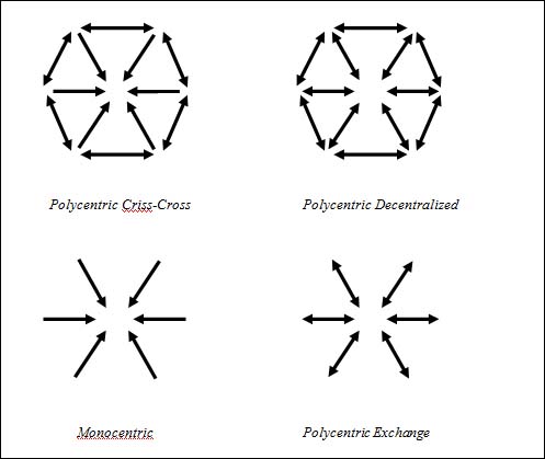
For conceptual clarification and in line with graph theoretical conceptualizations of spatial structure (e.g., Limtanakool et al., 2008), we explicitly disentangle the spatial structure of city-regionsfrom related aspects of the spatial organization of city-regions such as the degree of network density – or the extent to which the different parts of a city-region are functionally linked – and outward openness – or the extent to which the city-region is connected to other city-regions. Not including network density in our measure of functional polycentricity is necessary as it is possible to come across spatial systems that are strongly networked, but hierarchically organized and spatial systems that are not networked at all, but in which centres are relatively equal in terms of their connectivity to other centres. If both primacy and network density scores are combined, we may find that spatial systems with a highly unbalanced distribution of functional linkages but a high network density would receive a similar score as spatial systems with a highly balanced distribution of functional linkages but a low degree of network density (Burger and Meijers, 2010). A similar argument can be made with regards to the openness of a city-region. This does not mean that the degree of network density and openness are not important aspects of the spatial organization of a city-region. In actual fact, it can be expected that the increased mobility of households and firms will result in an increasing network density within city-regions as well as an increasing openness of city-regions. Moreover, it can be argued that a functional polycentric urban region is non-existent without a minimum degree of interaction between the centres (Champion, 2001; Parr, 2004). A Typology of City-Regions Based on CommutingBased on the orientation of commuting patterns in city regions8, it is possible to distinguish between four prototypical city-regions in Figure 2 (Van der Laan, 1998; Schwanen et al., 2003). In this, we distinguish between three types of journey-to-work patterns between different parts of a city-region: traditional commuting (commuting from the surrounding territory to the principal city), exchange commuting (commuting from the principal city to the surrounding territory) and criss-cross commuting (commuting between the different parts of the surrounding territory). The monocentric city-region is characterized by a low degree of exchange and criss-cross commuting in that the majority of commuters living in the surrounding territory travel to the principal city, while the surrounding territory hardly attracts commuters. In a polycentric exchange city-region, commuting has become reciprocal in that commuting is now no longer only directed from the surrounding territory to the principal city, but also from the principal city to the surrounding territory. In a polycentric criss-cross urban system, the different parts of the surrounding territory have become more dominant in that they now attract commuters from other parts of the surrounding territory. In this, different parts of the surrounding territory have become complementary to the principal city and are increasingly important as centres within the city-region. Commuting flows have become decentralized as the number of workers commuting between the different parts of the surrounding territory and bypassing the (former) principal city increases. Yet, the degree of exchange commuting remains low. Finally, a decentralized polycentric city-region is characterised by a multi-oriented commuting pattern in which there is no longer a dominant centre. In a polycentric decentralized system, the degree both criss-cross and exchange commuting is high. Two types of city-regions fit this classification, that is, (1) a formerly monocentric city-region in which employment has spread from the urban core to the urban fringe (‘edgeless cities’; Lang, 2003), and (2) city-regions characterised by the historical co-location of multiple smaller centres (i.e., conurbations). In such urban systems, the degree of traditional commuting may become very low. Figure 2: Functional Typology of the Spatial structure of City-Regions
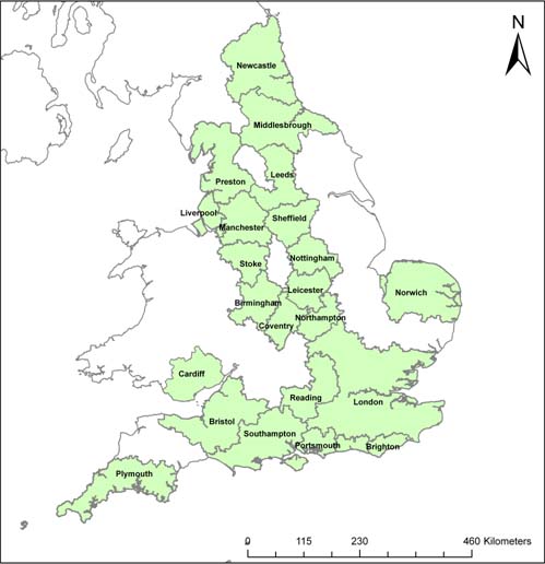
Empirical Setting and MethodologyPrevious Research on Commuting and Spatial Structure in England and WalesDespite a mounting theoretical literature on changing urban systems, only a small number of empirical studies have recently quantitatively assessed the development towards polycentric city-regions in England and Wales. To our knowledge, studies by Coombes et al. (2006), Nielsen and Hovgesen (2008), Green (2008) and De Goei et al. (2008; 2010) have analysed the dynamics of spatial structure in England and Wales empirically by using commuting data, where most work has been done on English and Welsh urban networks at the inter-regional scale (i.e. between supra-local territories). Analyzing commuting data for England and Wales, Green (2008) finds that the different parts of England and Wales are becoming have become more connected between 1981 and 2001 at the inter-regional scale. In addition, Green (2008) concludes that there is an increasing tendency for people both to live and to work at the urban periphery, where travel patterns have become increasingly diffused. On a similar note, Nielsen and Hovgesen (2008) examine the development of nation-wide commuting flows in England and Wales between 1991 and 2001. They find an increase of the average commuting distance in this period, which is exemplified by an increasing connectivity of the rural areas with the main centres. Focusing on commuting network in the Greater South East UK, De Goei et al. (2008; 2010) conclude that this mega-city region can still not be regarded as a functional polycentric urban region. However, they find some evidence for spatial integration at the supra-local scale (i.e., the city-region) as well as a decentralization of the system at the inter-regional scale in the sense that the hub function of London is decreasing in importance. On a similar note, Coombes et al. (2006) find some evidence for increasing linkage formation between the principal cities of the city-regions in the East Midlands urban network. However, the empirical literature on spatial structure in general and these studies in particular pay limited attention to spatial heterogeneity present between different city-regions. In the remainder of this article, the aim is to contribute to the existing empirical literature on urban systems by jointly addressing the dynamics, spatial heterogeneity and the specific polycentric pattern of the city-regions in England and Wales. Commuting and City-Regions in England and WalesTo analyse the development of metropolitan spatial structures in England and Wales, journey-to-work data between local authority districts for the years 1981 and 2001 is used. These data were obtained from the Special Workplace Statistics (Set C) in the British census.9 The CIDS 1991/2001 common geography is used to avoid potential problems with the changes of district-boundaries over the past twenty years (Boyle and Feng, 2002). Using the common geography, a subdivision of city-regions is made. In this, the classification by Coombes (2000) is used, which comprises 43 British city-regions. The city-regions are defined by functional linkages and areal associations based on the 2001 Census. In this, ‘the city-regions are delineated on the basis of commuting data through an algorithm that optimises the boundaries on the basis of a size of employment criterion and a minimum threshold of self-containment of flows to workplaces’ (Robson et al., 2006: 8). Accordingly, the classified city-regions are to a large extent self-contained in that most people (>80%) who work in those city-regions also live there. The delineation of Coombes (2000) is non-nodal and exhaustive since there may be several employment centres within each city-region and every area in Great Britain is allocated to a city-region. Compared to other classifications of city-regions in England and Wales (see Robson et al., 2006; Davoudi, 2008), an obvious advantage of the Coombes classification is that it does not a priori assume the existence of only one main centre within a city-region. Hence, such bottom-up approach of delineating city-regions is useful to explore polycentric patterns in a wider region (Davoudi, 2008). Based on the classification of city-regions by Coombes (2000), a selection of the 22 largest English and Welsh city-regions is made, whereby the more rural areas are excluded as these areas are typically not metropolitan (for a similar selection, see Champion and Coombes, 2007). An overview of the city-regions included in the analysis is presented in Figure 3. Figure 3: Selected 22 English and Welsh City-Regions
Quantifying the Spatial Structure of City-RegionsThe degree to which incoming commuting and employment is centralised within city-regions is estimated to assess the development of metropolitan spatial structure of English and Welsh city-regions between 1981 and 2001. To assess the degree of morphological and functional polycentricity in a city-region, we use a primacy index (Van der Laan, 1998; Adolphson, 2009). The morphological primacy index is calculated as the ratio of employment in the largest centre (i.e., the principal city) and the total employment the city-region and, hence, based on the balance in the distribution of nodality scores. The functional primacy index is calculated as the ratio of incoming commuting into the largest centre originating from the city-region and the total incoming commuting originating from the city-region and, hence, based on the balance in the distribution of internal centrality scores. A city-region is considered morphological monocentric if a city region’s employment is highly concentrated in one (principal) city. A city-region is considered functional monocentric if most commuting flows originating from other parts of the city-region are directed at the principal city (an no flows are directed from the principal city to the surrounding territory). The larger the degree of morphological and functional primacy in a city-region, the lower the degree of morphological and functional polycentricity in a city-region. In addition to the summary measures of polycentricity, we look at the specific patterns of polycentricity, which corresponds to the typology of polycentric spatial structures introduced in the previous section. In this, we make a distinction between the monocentric and three types of polycentric city-region: the exchange, the criss-cross, and the dencentralized city-region. This typology is based on 1) the degree of exchange commuting, or the degree to which commuters living in the principal city are oriented towards the surrounding territory and 2) the degree of criss-cross commuting, or the degree of commuting between different parts of the surrounding territory. We compare the degree of exchange and criss-cross commuting with the degree of traditional commuting, where commuting is defined as journey-to-work travels between the area of residence and another area of employment. Hence, we exclude here journey-to-work travel of people who work and live in the same area. A more technical description of these measures is provided in Table 1. Table 1: Orientation of Commuting and Four Types of Urban Systems
Building on the discussion in the previous sections, we look at two additional features of city-regions. The degree of network density reflects the extent to which different parts of the city-region are networked or functionally interdependent and can be measured as the ratio of the actual connections between the different parts of the city-region to the total of potential connections between the different parts of the city-region (Green, 2007). Here, the total potential connections between the different parts of a city-region can be defined as the total number of employees in a city-region. A generally low ratio of the sum of internal centrality scores of the different parts of the city-region to the number of employees within a city-region indicates a low level of network density. Likewise, the openness of a city-region can be defined as the ratio of the number of employees in a city-region that are residing in other city-regions and total employment in a city-region (Patuelli et al., 2009).10 Empirical ResultsSpatial Organization of English and Welsh City-RegionsTable 2 indicates the spatial organization of the 22 selected city-regions in England and Wales in 2001 on the basis of employment and commuting trips. Based on the morphological and functional primacy indices, it can be concluded that a functional and morphological polycentric pattern is to at least some extent present in the majority of city-regions. On average, only 36.7% of the incoming commuting flows the own city-region and 28.8% of the number of employees is concentrated in the principal city. Middlesbrough, Preston, Reading and Southampton are relatively the most polycentric city-regions in England and Wales. Other city-regions, such as Nottingham, Leeds and Leicester, can still be characterised as relatively monocentric. Overall, there is a strong correlation between the degree of functional and morphological polycentricity of 0.77 (see also Table 3); city-regions that are relatively functional polycentric are also relatively morphological polycentric. Table 2: Spatial Organization of English and Welsh City-Regions (2001)
Now we turn to two different but related aspects of the spatial organization of city-regions, the degree of network density and outward openness. From Table 2 it can be obtained that on average 28% of the employees in a city-region are commuting between different parts of the city-region, while approximately 10% of the employees are living outside the city-region in which they work. However, there are considerable differences between city-regions, especially with regards to the degree of network density. London11 appears to be the most networked city-region, with over half of its employees commuting between the different parts of the city-region.12 With respect to the outward openness of city-regions, it can be obtained that (unsurprisingly) the geographically isolated city-regions (Cardiff, Middlesbrough, Newcastle and Plymouth) are the most closed ones, while smaller city-regions located in between larger city-regions (Coventry, Northampton, Reading) are the most open ones. Concerning the relationship between the different aspects of the spatial organization of city-regions (see Table 3), there is fairly strong negative correlation between the degree of morphological primacy and network density. This means that in city-regions that are more morphological polycentric are characterized by a higher degree of integration between the different parts of the city-region. However, such relationship between the degree of functional primacy and network density is virtually non-existent. This means that functional polycentric city-regions are not more networked than functional monocentric city-regions, which supports the decision not to combine these two measures into one index. City-regions that are relatively polycentric are less open than city-regions that are relatively monocentric. As indicated by Burger and Meijers (2010), this can be explained by the fact that monocentric city-regions often have a disproportionately large centre with a relative overrepresentation of higher-order functions. As it is well known that higher-ranked employees (in terms of education and income) are willing to commute longer distances to work (Schwanen and Dijst, 2002), these city-regions are more likely to attract employees residing in places outside the city-region.13 Table 3: Correlation Matrix of the Different Dimensions of the Spatial Organization of City-Regions
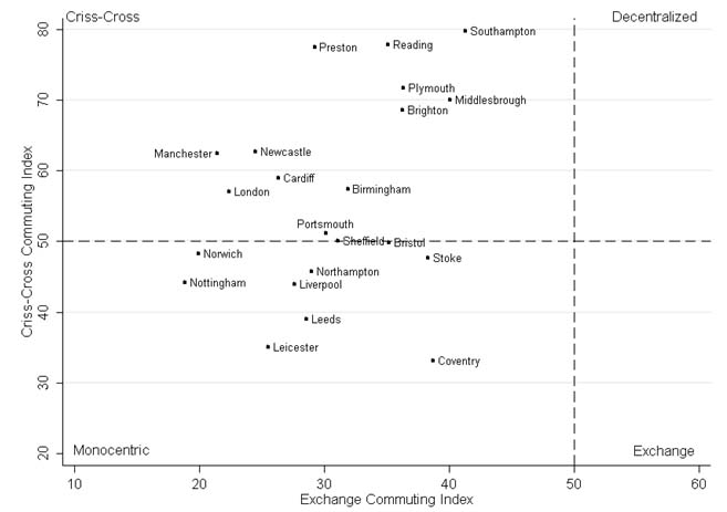
Yet, polycentricity can have many faces and polycentric spatial structures differ across city-regions. Figure 4 indicates the presence of specific polycentric patterns for the different English and Welsh city-regions. The demarcation lines represent the point at which the volume of criss-cross commuting is equal to the volume of traditional commuting and the point at which the volume of exchange commuting is equal to the volume of traditional commuting. The values on the horizontal axis indicates the ratio of the volume of exchange commuting to the volume of traditional commuting, while the values on the vertical axis indicate the ratio of the volume of criss-cross commuting to the volume of traditional commuting. From this figure, it can be observed that the monocentric model and decentralized polycentric model prevail. With respect to the indicated geographical differences in metropolitan spatial structure, the city-regions in the triangle Nottingham-Sheffield-Leicester have a relatively monocentric structure. Bristol, Coventry and Stoke represent to some extent more an exchange commuting model. Brighton, Middlesbrough, Plymouth, Preston, Reading and Southampton can be characterised as city-regions in between a criss-cross and decentralized spatial structure. In the latter three city-regions, the volume of criss-cross commuting is even over three times the volume of traditional commuting. The large city-regions around London, Birmingham, Newcastle, Cardiff, and Manchester can be characterized as city-regions in between a monocentric and criss-cross spatial structure. Most strikingly, many city-regions in South East England are characterised by a relatively high level of decentralization, while the larger city-regions in North England and the Midlands tend to have the most monocentric spatial structures. Figure 4: Functional Spatial Structures in England and Wales (2001)
The Dynamics of the Spatial Structure of City-Regions, 1981-2001This section discusses the changes in the spatial organization of the 22 English and Welsh city-regions over the two last decades of the 20th century. Table 4 shows the change in spatial organization between 1981 and 2001 in terms of percentage points (pp). A number of conclusions can be drawn. First, there is clearly a tendency towards polycentric spatial structures, which is exemplified by a general decrease of morphological and functional primacy. In addition, city-regions have become more networked and open. Table 4: Changes in Spatial Organization of English and Welsh City-Regions in Percentage Points (1981-2001)
Second, and with respect to geographical differences, the pace of polycentric development has generally been faster in city-regions in the Midlands and South England than in city-regions in North England and Wales. Bristol, Coventry, Leicester, London, Portsmouth, and Stoke have shown the largest polycentric development, closely followed by Birmingham, Norwich and Plymouth. In this, London and Portsmouth show a much greater tendency towards a functional polycentric structure than towards a morphological polycentric structure.14 On the contrary, Leeds and Nottingham have become more monocentric, while the spatial structures of while the metropolitan spatial structures of other city-regions (Cardiff, Middlesbrough, and Sheffield) have hardly changed. In general, there is a high correlation of 0.84 between change in functional primacy and the change in morphological primacy (see Table 5). Table 5: Correlation Matrix of Changes in the Different Dimensions of the Spatial Organization of City-Regions
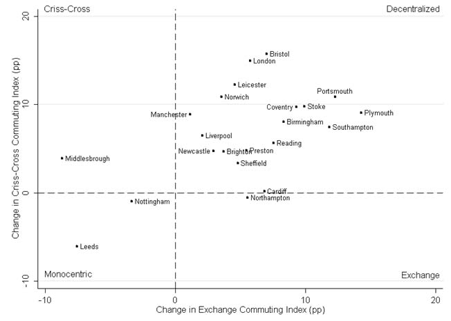
Yet, the city-regions that have become relatively more polycentric have not become relatively more networked: Middlesbrough and Cardiff have shown a much higher degree of integration than London or Portsmouth and there is then also a strong positive correlation of about 0.55 between an increase in functional or morphological primacy and an increase in network density. Although this might appear counterintuitive, it can be explained that a relative decrease in journey-to-work trips from the surrounding territory to the principal city coincides with a relative increase of journey-to-work trips within the different parts of the surrounding territory. There appears to be hardly any correlation between changes in outward openness and changes in primacy. Turning to the development of specific spatial structures (Figure 5), it can be obtained that most city-regions are developing towards a more decentralized spatial structure, where city-regions in South England and the Midlands tend to do this at a faster pace than city-regions in North England and Wales. In Cardiff and Northampton only some exchange commuting and in Middlesbrough only some criss-cross commuting is developing. Figure 5: Change in Functional Spatial Structure in England and Wales (1981-2001)
These findings are supported when looking at the shift in relative share of the different types of journey-to-work trips in the city-regions over time (see Table 6). From this table, it can be obtained that many city-regions experienced a large decrease in the share of journey-to-work trips within the principal city (column 1) and a small decrease in the relative share of journey-to-work trips within the different parts of the surrounding territory (column 2). As far as the relationship between the principal city and its surrounding territory is concerned, column 3 shows a decrease in the relative number of journey-to-work trips from the surrounding territory to the principal city (ST à PC; column 3; traditional commuting) and an increase of the flows from the principal city to the surrounding territory (PC à ST; column 4; exchange commuting). From this, it can be concluded that the surrounding territory has become relatively more important. The latter point is also strengthened by the fact that the share of commuting between the different parts of the surrounding territory (ST à ST; column 5; criss-cross commuting) has increased. Overall, the surrounding territory became more important as final destination for journey-to-work trips. Table 6: Spatial Organization of English and Welsh City-Regions (2001)
City-regions which experienced a considerable shift toward a decentralized metropolitan spatial structure are often also the city-regions which experienced a relatively large decrease in the share of principal city residents that are employed in the principal city (Table 3; within PC; column 1) or a large decrease in the share of traditional commuting (Table 5, column 3) in the case of London. With respect to the surrounding territories, we find that particularly city-regions in which the different parts of the surrounding territory have experienced an increase or only a small decrease in the share of journey-to-work trips within the different parts of the surrounding territory (Table 3; within ST; column 2) have decentralized most. This indicates that an increasing labour demand within the different parts of the surrounding territory coincides with a rise of criss-cross and exchange commuting and a decrease of traditional commuting. Yet, the amount of decentralisation is on average still rather modest and the spatial structure of city-regions is generally changing at a low pace. Given the time period of 20 years, it can be argued that radical changes in the spatial structure of English and Welsh city-regions did not occur. However, there are also considerable differences between city-regions in that their spatial structures can move in different directions and at a different pace. Table 5 shows by the grey-marked cells which city-regions showed the largest changes. Coventry, Leicester and Stoke had both a rather large decrease in the share of the commuting within the principal city and a rather large growth of the commuting within the different parts of the surrounding territory. In Cardiff, Middlesbrough, Leeds, Newcastle, Northampton and Preston, the share of the commuting within the surrounding territory decreased considerably. It is particularly London which had a relatively large decrease in traditional commuting as well as a large increase of the share of criss-cross commuting. The latter share also significantly increased in the Middlesbrough, Newcastle and Southampton city-regions. It is clear that city-regions which have moved to more functional polycentric spatial structure are characterized by both a decrease of traditional commuting in combination with an increase of exchange and criss-cross commuting. The observation that London and Portsmouth show a much greater tendency towards a functional polycentric structure than towards a morphological polycentric structure can easily be explained by the fact that the decrease in the share of journey-to-work trips within the principal city has been limited in these city-regions. Concluding Remarks and LimitationsIn the urban geography and planning literature it is often assumed that all modern metropolitan systems are becoming polycentric. At the same time, the heterogeneity in the development of city-regions has not been the main object of study. Our analysis based on commuting and employment data shows that, although many city-regions can be regarded as polycentric, the spatial structure is differing considerably across city-regions. A related question is which kind of spatial structure prevails in specific regions. Over the period 1981 – 2001 a trend towards decentralisation in the spatial structure can be observed across city-regions. These results are in line with the findings of De Goei et al. (2010) for the Greater South East, which also observed a decentralisation trend at the supra-local scale, exemplified by a relative increase in exchange and criss-cross commuting. Similar trends towards decentralisation of employment and population at the supra-local scale are observed in Denmark (Nielsen and Hovgesen, 2005), France (Aguilera and Mignot, 2004), and Germany (Guth et al., 2009). Nevertheless, the extent of change in the overall spatial pattern is rather modest. In addition, the results show a large spatial differentiation. It was found that not all city-regions are moving in the same direction. Most notably, whereas the majority of city-regions in South East England and the Midlands are becoming more polycentric, the spatial structure of many city-regions in North England is hardly changing or even becoming more monocentric. Having observed these different trends, the question remains why some city-regions move to some sort of polycentric form and other city-regions do not. Further empirical research should address this question in detail by quantitatively linking the spatial heterogeneity in the dynamics of metropolitan spatial structure to the heterogeneity in the initial shape, economic and socio-cultural developments and local and regional land use policies across city-regions. Further research can use different approaches (De Goei et al., 2010). First, the relationship between changing metropolitan spatial structure and the increasing flexibility and mobility of firms can be explored in more detail. In particular, the link between advancements in transport, ICT, shift towards a service economy, and changes in metropolitan spatial structure in general deserves further analysis. A starting point here would be the research of Ioannides et al. (2008), who showed that ICT weakens agglomeration forces and provides incentives to relocate economic activities to smaller centres. In this, particularly attention should be drawn how changes in the balance between agglomeration economies and diseconomies (pollution, crime) trigger changes in the spatial organization of metropolitan areas and how agglomeration economies are shared among a group of functionally linked centres (Meijers and Burger, 2010). Secondly, the relationship between the changing metropolitan spatial structure and increasing flexibility and mobility of households can be further examined. Advances in transport and ICT make households not only more mobile but can also change residential preferences. Advances in transport and ICT potentially allow changes in the demography of developed economies and life styles of people to have an effect on metropolitan spatial structure (Champion, 2001). Such demographic developments include the rise of two-earner and single person households, the increasing number of women working, a higher life expectancy, and a lower fertility (Hall and White, 1995). The common factor in these demographic developments is that they have changed the residential preferences of large groups of people, causing changes in the spatial organization of urban systems (Van Ham, 2002). Thirdly, the effect of local and regional policies on metropolitan spatial structure is a matter that can be analysed further. This includes both policies that have the explicit intention to change metropolitan spatial structure and policies which unintentionally result in a change in metropolitan spatial structure. Likely, here are multiple drivers behind the changing spatial organisation of city-regions. However, these drivers may differ across city-regions. In addition, changes in spatial organization are also determined by how city-regions were initially shaped. Accordingly, it will be important to distinguish between different city-regions and different determinants of metropolitan spatial structure. Although it can be argued that commuting constitutes one of the most important economic interactions within a city-region, an important limitation of this study is that it only looks at commuting and employment data. Several authors have pointed out that journey-to-work travel is not a perfect indicator for all economic interaction within a territory and should be used alongside other forms of economic interaction to gain a realistic insight into the interdependence of places and structure of urban systems (Lambregts et al., 2005; Hewings and Parr, 2007). Accordingly, policymakers should be careful drawing inferences solely based on this study. Places are not only functionally connected through labor market relations, but also through trade, capital movements, leisure trips, and shopping trips (Lambooy, 1998; Parr, 2005). Admittedly, commuting trips are often the only type of data available and may provide a surrogate representation of other types of spatial interaction (Parr, 2005).Yet, the degree to which commuting relations are a good proxy for other types of spatial interaction is far from clear and should be addressed in future research on metropolitan spatial structure. In particular, it is interesting to examine whether polycentric city-regions can still be regarded as functional polycentric when other types of economic interaction are taken into consideration. A similar point can be made with regards to morphological polycentricity and the internal characteristics of centers taken into consideration. In addition, it should be forewarned that the evaluation of spatial structure is quintessentially scale-dependent and contingent on both the choice of analytical frame (European, national, regional, local) and the measurement of functional spaces dependent on the type of economic interaction (Hall and Pain, 2006; Parr, 2008).15 In our analysis, we evaluated the spatial structure of city-regions delimited on the basis of commuting and employment data. However, some urban functions have a larger geographical scope and are concentrated in only a few major cities. One can here think of functions centers of command and centers as suppliers of specialized goods and services (Parr, 2008). In this light, the city-regions Brighton, London, Northampton, Reading, Southampton and Portsmouth studied in this article can be considered secondary city-regions within some primary city-region at a higher geographical scale with London as principal centre.Lambregts et al. (2005: 32) then also rightly remark that ‘polycentricity is up to certain extent in the eye of the beholder’. Preferably, indicators that suggest that a territory is polycentric should be weighed against indicators that suggest that a territory is not really polycentric, taking into account the spatial scale at which polycentricity is studied. Only in this fashion, it will be possible to completely grasp how territories are spatially organized and how this spatial organization changes over time. Such thorough understanding of these processes is necessary in order to explain the dynamics of spatial structure and, eventually, to inform policy. REFERENCESAdolphson, M (2009) Estimating a polycentric urban structure. Case study: urban changes in the Stockholm region, Journal of Urban Planning and Development 135, pp. 19-30. Aguilera, A and Mignot, D (2004) Urban sprawl, polycentrism and commuting. A comparison of seven French urban areas. Urban Public Economics Review 1, 93-113. Alonso, W (1964) Location and Land Use, Harvard University Press, Cambridge MA. Batten, D F (1995) Network cities: creative urban agglomeration for the 21st century. Urban Studies 32, 313-327. Berry, B J L (1964) Cities as systems within systems of cities. Papers of the Regional Science Association 13, 147-163. Boyle, P and Feng, Z (2002) A method for integrating the 1981 and 1991 British census interaction data. Computers, Environment and Urban Systems 26, 241-256. Burger, M J and Meijers, E J (2010) Form follows function? Linking morphological and functional polycentricity. Working Paper, GaWC Research Bulletin 344. Burger M J, Van Oort F G, Van der Knaap, G A (2010) A treatise on the scale-dependence of agglomeration externalities and the MAUP, Scienze Regionali 9, pp. 19-40. Champion, A G (2001) A changing demographic regime and evolving polycentric urban regions – consequences for the size, composition and distribution of city populations. Urban Studies 38, 657-677. Champion, T and Coombes, M (2007) Using the 2001 census to study human capital movements affecting Britain’s larger cities: insights and issues. Journal of the Royal Statistical Society A (Statistics in Society) 170, 447-467. Clark, WAV and Kuijpers-Linde, M (1994), Commuting in restructuring urban regions, Urban Studies 31, 465-483 Christaller, W (1933) Die Zentralen Orte in Süddeutschland, Gustav Fischer, Jena. Coombes, M (2000) Defining locality boundaries with synthetic data. Environment and Planning A 32, 1499-1518. Coombes, M G, Charles, D R, Raybould, S R and Wymer, C (2006) City Regions and Polycentricity: The East Midlands Urban Network, East Midland Development Agency, Nottingham. Cörvers, F, Hensen, M, Bongaerts, D (2009) The delimitation and coherence of functional and administrative regions, Regional Studies 43, 19-31. Davoudi, S (2008) Conceptions of the city-region: a critical review. Urban Design and Planning 16, 51-60. De Goei, B, Burger, M J, Van Oort, F G and Kitston M (2008) Testing the super-region. Town and Country Planning 77, 458-464. De Goei, B, Burger, M J, Van Oort, F G and Kitson M (2010) Functional polycentrism and urban network development in the Greater South East UK: Evidence from commuting patterns, 1981-2001. Regional Studies (forthcoming). Garreau, J (1991) Edge City: Life on the New Frontier, Doubleday, New York. Green, N (2007) Functional polycentricity: a formal definition in terms of social network analysis. Urban Studies 44, 2077-2103. Green, N (2008) City-states and the spatial in-between. Town and Country Planning, 223-231. Guth D, Holz-Rau C, Maciolek M (2009) Employment suburbanisation and commuter traffic in German city regions. Working paper, TU Dortmund. Hall P (2001) Global city regions in the twenty first century. In: Scott, A J (Ed.), Global City Regions: Trends, Theory, Policy, Oxford University Press, Oxford UK, pp. 59-77. Hall, P and Pain, K (2006) (Eds) The Polycentric Metropolis: Learning from Mega-City Regions in Europe, Earthscan, London. Hall, R and White, P (1995) Europe’s Population: Towards the Next Century, University College London Press, London. Hoyler, M, Kloosterman, R C and Sokol, M (2008) Polycentric puzzles – Emerging mega-city regions seen through the lens of advanced producer services. Regional Studies 42, 1055-1064. Iaonnides, Y M, Overman H G, Rossi-Hansberg E, Schmidheiny K (2008) The effect of information and communication technologies on urban structure. Economic Policy April 2008, 201-242. Kloosterman, R C and Musterd, S (2001) The polycentric urban region: towards a research agenda. Urban Studies 38, 623-633. Kloosterman, R C and Lambregts, B (2001) Clustering of economic activities in polycentric urban regions: the case of the Randstad. Urban Studies 38, pp. 717-732. Kloosterman, R C and Lambregts, B (2007) Between accumulation and concentration of capital: toward a framework for comparing long-term trajectories of urban systems. Urban Geography 28, 54-73. Lambregts B., Kloosterman, R C, Van der Werff, M (2005), Polycentricity and the eye of the beholder: A multi-layered analysis of spatial patterns in the Dutch Randstad, Romanian Economic Journal 8, pp. 19-34. Lang, R E (2003) Edgeless Cities: Exploring the Elusive Metropolis, Brookings Institution Press, Washington DC. Lee, B (2007) Edge or edgeless cities? Urban spatial structure in U.S. metropolitan areas, 1980 to 2000. Journal of Regional Science 47, 479-515. Limtanakool, N, Schwanen, T and Dijst, M (2008) Ranking metropolitan areas: a comparison of interaction and node attribute data. Cities 27, 26-42. Lösch A (1944), Die Räumliche Ordnung der Wirtschaft, Gustav Fischer, Jena. Meijers, E (2007) From a central place to a network model: theory and evidence of a paradigm change. Tijdschrift voor Economische en Sociale Geografie 98, 245-259. Meijers, E (2008) Measuring polycentricity and its promises. European Planning Studies 16, 1313-1323. Meijers, E and Burger M J (2010) Spatial structure and productivity in US metropolitan areas. Environment and Planning A 42, 1383-1402. Nielsen, T A S and Hovgesen, H H (2005) Urban field in the making: new evidence from a Danish context, Tijdschrift voor Economische en Sociale Geografie 96, pp. 515-528. Nielsen, T A S and Hovgesen, H H (2008) Exploratory mapping of commuter flows in England and Wales. Journal of Transport Geography 16, 90-99. Nitsch, V (2003) Does history matter for urban primacy? The case of Vienna. Regional Science and Urban Economics 33, 401-418. Openshaw and Taylor Parr, J B (1987) Interaction in an urban system: aspects of trade and commuting. Economic Geography 63, pp. 223-240. Parr, J B (2004) The polycentric urban region: a closer inspection, Regional Studies 38, 231-240 Parr, J B (2005) Perspectives on the city-region. Regional Studies 39, 555-566. Parr, J B (2008) Cities and regions: problems and potentials. Environment and Planning A 40, pp. 3009-3026. Parr, J, Hewings, G (2007) Spatial interdependence in a metropolitan setting, Spatial Economic Analysis 2, pp. 8-22. Preston, R E (1971) The structure of central place systems. Economic Geography 47, pp. 136-155. Richardson, H W (1995) Economies and diseconomies of agglomeration, in: H. Giersch (Ed) Urban Agglomeration and Economic Growth, pp. 123-155. Berlin: Springer. Robson, B, Barr, R, Lymperopoulo, K, Ress, J and Coombes, M G (2006) A Framework for City Regions – Working Paper 1: Mapping City-Regions, Office of the Deputy Prime Minister, London. Schwanen, T, Dieleman, F M and Dijst, M J (2003) Car use in Netherlands Daily Urban Systems: does polycentrism result in lower commute times? Urban Geography 24, 340-360. Small, K and Song, S (1994) Population and employment densities: structure and change. Journal of Urban Economics 36, 292-313. Spiekermann, K and Wegener, M (2004) How to Measure Polycentricity? Paper presented at ESPON 1.1.3 Project Meeting, Warsaw, Poland, June 2004. Tosics, I (2004), European urban development: Sustainability and the role of housing. Journal of Housing and the Built Environment 19, 67-90. Van den Berg, L, Drewett, R, Klaasen, L H, Rossi, A and Vijverberg, C H T (1982) Urban Europe: a Study of Growth and Decline. Oxford: Pergamon Press. Van Ham, M (2002) Job Access, Workplace Mobility, and Occupational Achievement. Delft, Eburon Publishers Van der Laan, L (1998) Changing urban systems: an empirical analysis at two spatial levels. Regional Studies 32, 235-249. Van der Laan, L, Vogelzang, J and Schalke, R (1998) Commuting in multimodal urban systems: an empirical comparison of three alternative models. Tijdschrift voor Economische en Sociale Geografie 89, 384-400. Van Oort, F G, Burger M J and Raspe, O (2010) On the economic foundation of the urban network paradigm. Spatial integration, functional integration and urban complementarities within the Dutch Randstad, Urban Studies 47, 725-748.
NOTES* Martijn Burger, Department of Applied Economics, Erasmus University Rotterdam and ERIM, Email: mburger@ese.eur.nl, URL: http://www.mjburger.net. ** Bastiaan de Goei, Judge Business School and Fitzwilliam College, University of Cambridge, UK, Email: bd275@cam.ac.uk. *** Lambert van der Laan, Department of Applied Economics, Erasmus University Rotterdam, Email: vanderlaan@ese.eur.nl. **** Fieke Huisman, Department of Economics, Erasmus University Rotterdam, Email: fhuisman@ese.eur.nl. 1. For example, city-regions characterised by the historical co-location of multiple smaller centres (i.e., conurbations), such as the area around Middlesbrough. 2. In this, it should be acknowledged that Hall and Pain (2006) specifically reported on differences between European mega-city regions in relation to their degree of polycentricity at the inter-regional scale. 3. Yet, the concept of city-region is in fact much older and dates back to the work of Lösch (1944). A good overview of the development of the city-region concept is provided by Parr (2005) and Davoudi (2008). 4. For example, the city-region of Newcastle contains the principal city Newcastle, the suburbs Gateshead, North Shields and South Shields, the lower order urban centres Chester-le-Street, Durham and Sunderland, and rural areas in Tynesdale and North Northumberland. 5. It should be noted that, over time, the monocentric model could also over-predict commuting distance as total commuting distance could drop when more people work and live in sub-centres (Small and Song, 1994). However, this would also mean that the predictions from the monocentric model are no longer reliable. 6. The use of polycentricity should not be confused with the concept of multicentricity. Multicentricity refers to the existence of multiple centres, while polycentricity emphasises a certain balance in importance of these centres. 7. See Burger and Meijers (2010) for a more elaborate discussion of these issues. 8. It should again be stressed that we look here only at the directionality of the linkages between the different parts of the city-region and not at the strength of the linkages between the different parts of the city-region. 9. Census output is Crown copyright and is reproduced with the permission of the Controller of HMSO and the Queen's Printer for Scotland. Sources: 1981 Census: Special Workplace Statistics (Set C) and 2001 Census: Special Workplace Statistics (Level 1) 10. Alternatively, this measure can be conceptualized as the ratio of the sum of external centrality scores of the different parts of the city-region divided to the sum of nodality scores of the different parts of the city-region. 11. Central London as principal city is here defined as the Camden, City of London, City of Westminster, Islington, Kensington and Chelsea, Lambeth and Southwark with together form the Central London Partnership. 12. However, part of the variation between city-regions can be explained by the different areal units used to characterize the different parts of the surrounding territory. While for London boroughs are used 13. Of course, the assessment of mono/polycentricity is to some extent dependent on the territorial delineation used as relations outside the region are not taken into account here. This is in geography better known as the Modifiable Areal Unit Problem (MAUP) (Openshaw and Taylor, 1979; Burger et al., 2010). However, given that the city-regions in our study are to a large extent self-sufficient in terms of employment, we expect that this problem is limited in our analysis. 14. Yet, overall, there is a strong correlation of 0.84 between the change in functional primacy and the change in morphological primacy. 15. Of course, the delimitation is to some extent also dependent on the delimitation algorithm and procedure that is used (Cörvers et al., 2009).
Note: This Research Bulletin has been published in Cities, 28 (2), (2011), 160-170 |
||||||||||||||||||||||||||||||||||||||||||||||||||||||||||||||||||||||||||||||||||||||||||||||||||||||||||||||||||||||||||||||||||||||||||||||||||||||||||||||||||||||||||||||||||||||||||||||||||||||||||||||||||||||||||||||||||||||||||||||||||||||||||||||||||||||||||||||||||||||||||||||||||||||||||||||||||||||||||||||||||||||||||||||||||||||||||||||||||||||||||||||||||||||||||||||||||||||||||||||||||||||||||||||||||||||||||||||||||||||||||||||||||||||||||||||||||||||||||||||||||||||||||||