GaWC Research Bulletin 34 |
|
|
|
This Research Bulletin has been published in GeoJournal, 52 (2), (2000), 157-162.
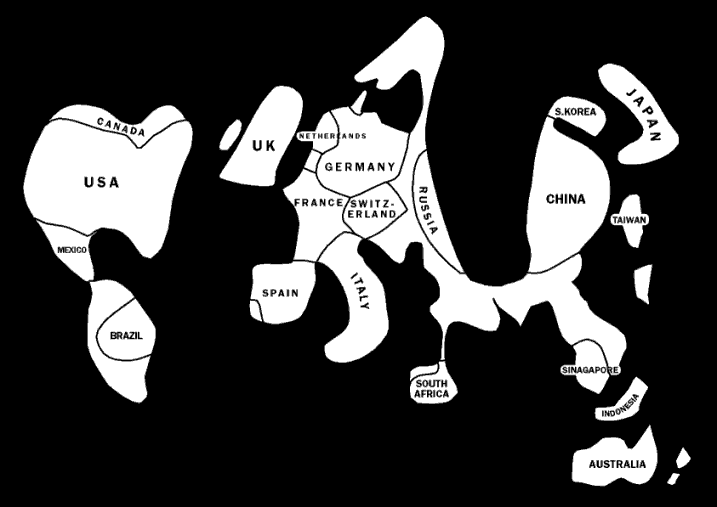
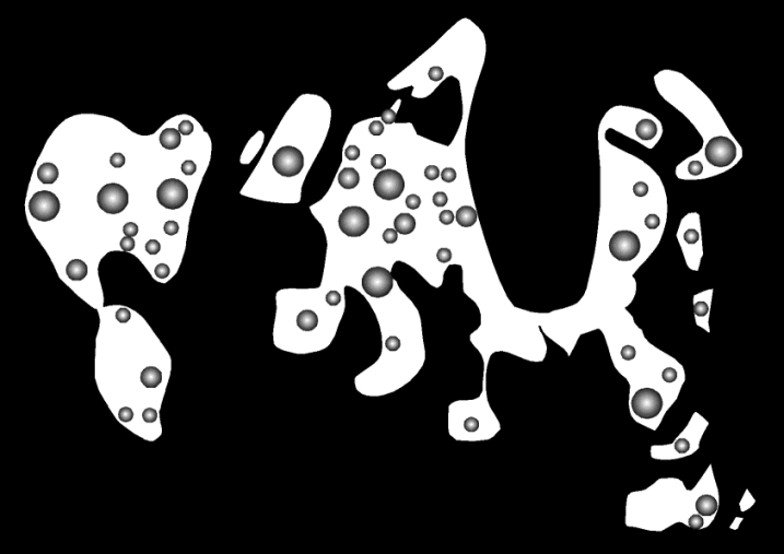
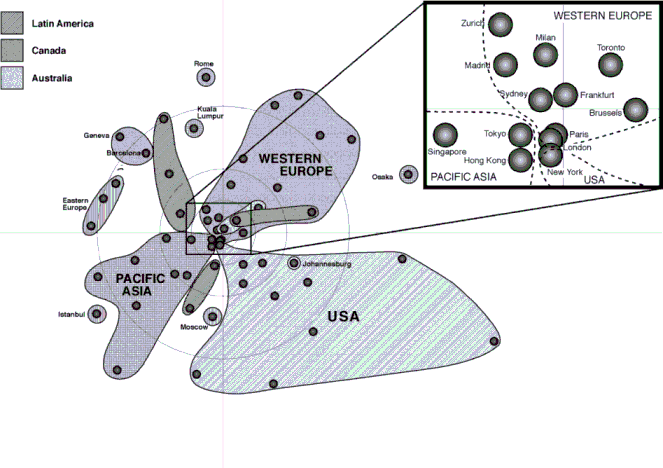
This paper is a follow up to my 1999 Political Geography Annual Lecture (Taylor 2000). It reports on some of the work of the Globalization and World Cities (GaWC) Study Group and Network providing both an update and an introduction of new themes that have emerged. In particular I focus on two issues raised in the presentation of that lecture: first, the specific question of network analysis as emphasised in one of the published commentaries (Shapiro 2000); and second, the very general issue of the nature of politics this analysis implies. As a keynote address to a conference sponsored by the International Geographical Union's Commission on the World Political Map, it is apt that the core argument of this paper queries the future centrality of the world map of state boundaries for the study of political geography in the twenty first century. One way of viewing GaWC is that it is attempting to put the geography back into globalization. Although intrinsically geographical in nature, globalization is often treated as an aspatial 'thing', a set of processes that blanket the world. To be sure there are homogenizing tendencies within contemporary globalization but equally there are many counter-tendencies. The result is an uneven globalization which is most clearly shown by world city formation: this process is concentrated in the three regions of northern America, western Europe and Pacific Asia. I begin this paper with a stark illustration of this new geography to contrast with political geography's most famous global image, the heartland model. My basic thesis is that there is no reason for political geographers to be left behind contemplating their traditional myopic global view: let us accept the century-old plaudits for being first with a plausible global analysis and move on to consider the very different questions that economic globalization poses. The second section argues that we need to think of a political geography that goes beyond traditional social science, a tradition that reifies the state. In the next section world cities are treated as alternatives to the state, supplementing the previous discussion on spatial monopolies by a new argument about their roles in metageographies. The world city network is specified in the next section and the structure of its politics is summarised. As a brief conclusion, I return to the question of how contemporary globalization relates to past global patterns of activity through examining changing relations between spaces of places and spaces of flows. A HUNDRED YEARS ON (IN THE GLOBAL TRADITION): AN 'UNHEARTLAND' MODELPortraying very uneven distributions on maps is a common problem in cartography. Accurately locating symbols can lead to severe overlapping thus obscuring patterns and confusing interpretation. In the original lecture, 'the world according to GaWC' (Taylor 2000, Fig. 2) did not use a 'real space' to show world cities but located them apart from one another while maintaining approximate relative locations. However, the usual way of portraying very uneven distributions is to construct a cartogram (Tobler 1963; Dorling 1994). The most common is the world population cartogram wherein China and India dominate in the 'demographic space' at the expense of large but low population density countries such as Canada and Australia. Here I create a cartogram showing 'world city formation space'. In the original research on world city formation 122 cities were scored between 1 and 12 in terms of their 'world city-ness' (Beaverstock et al. 1999). From these scores, totals of world city formation can be computed for each country; for instance the UK sum is 19 (London 12, Birmingham and Manchester both 2, Edinburgh, Glasgow and Leeds one each). It is these country sums that define the world city formation space. In Figure 1 each country is shown in proportion to its total score resulting in massive areal distortion to the world map. However, the secret of a good cartogram is to maintain shape and relative location so that the mapreader can recognise places. This enables comparisons to be made between the cartogram and the familiar area-based spatial image. This is achieved in Figure 1 and the comparison for a political geographer is startling. The heartland model is explicitly an areal model of global political geography. Whether the heartland is defined by its remote defensive location or its raw material potential, its power derives from its areal extent. This may have been relevant when the trans-Siberian railway was the wonder of the age but it is hardly a key to world power in the twenty first century. In our 'information age' knowledge, more than ever before, is power. And it is in world cities that concentrations of knowledge, particularly in the advanced producer services (accountancy, advertising, banking/finance, insurance, law, management consultancy, etc.), enable the contemporary global economy to operate. World cities, therefore, are spatial expressions of power and wealth within contemporary globalization. They define a spatial structure through which many key global processes flow. Hence Figure 1 can be said to portray a new map of world power. I have called it an 'unheartland model' for the obvious reason that world cities are conspicuous by the absence in most of the traditional heartland. It may still contain some nuclear weapon silos but there has been a severe power shift since the decline and demise of the USSR and Figure 1 illustrates the geographical change. This is the world-space that political geographers have to deal with in twenty first century. POLITICAL GEOGRAPHY WITHIN SOCIAL SCIENCE: BEYOND EMBEDDED STATISMHow is this new world-space related to political geography with its tradition for investigating states and their depiction on the world political map? I tackle this question in two stages, both of which require the argument to go beyond the confines of our sub-discipline. This section locates political geography within the contemporary travails of social science, the next section provides the even broader context of metageographies. Political geography is not an island and looking forward requires an understanding of what is going on in both academe and beyond under conditions of contemporary globalization. Political geography in the twentieth century focused its study on the state. At a time when the nation-state dominated the political imagination, courtesy of the nineteenth century merger of political state and cultural nation, it was, of course, entirely appropriate that Ratzel, Mackinder, Bowman, Whittlesey, Hartshorne and their followers should construct a political geography with the nation-state at its centre (Taylor and van der Wusten 2001). The problem is that the nation-state was no ordinary institution, making it a subject of study was fine but it was also always simultaneously the object of study. Hence the nationalities of the 'founding fathers' is so very clear in their writings. This is a particular reflection of what I have called embedded statism (Taylor 1996) and it afflicted much more than our small corner of the social sciences. Embedded statism is a way of thinking which treats nation-states as the 'natural units' of humanity. It may not always use a biological metaphor but it is, nevertheless, taken for granted that society, economy and polity all cover exactly same areal extent, sovereign state territory. Such state-centric thinking in social science incorporates an unexamined geography at the heart of its theories so that social theory, economic theory and political theory in the twentieth century have incorporated this implicit spatial limit. But perhaps the most surprising feature has been in empirical analyses where statistics - data produced by and for states - have been accepted with little or no quibble as to their authenticity as descriptors of the world. All official comparative data (e.g. in various UN publications) are about states (because that is where the UN gets its information). Furthermore, this state provenance means that most data are about attributes (states counting their populations and their characteristics, and measuring their land/economy and its properties) with relatively little on relational measures of the flows, connections and linkages that make our world work (Taylor 1997). The result is a massive imbalance in our social science knowledge with a bias towards comparative attribute studies and relational studies limited to the 'international'. It is this embedded statism that is being undermined by contemporary globalization (Taylor 1996). Globalization incorporates at its core three features which force the hidden geography in social science out into the open. First, and most obviously, it involves a different scale of human activities: the state is often said to be challenged from 'above' (the supra-national) and 'below' (the sub-national). Second, globalization incorporates transnational processes rather than international ones: state borders are being eroded as obstacles in key sectors such as finance. Third, globalization is explicitly about a space of flows: the new global 'network society' cannot be equated with traditional 'national society'. In these circumstances the nation-state can no longer be taken for granted as the basic unit of investigation. Certainly it should not be neglected but it must be seen within context: the geography within social science can no longer be implicit. Given the nature of political geography, it may well be that we will find it harder than most to escape from the prison of embedded statism. Notice, however, that I am not advocating giving up state studies, rather we should view them in a different light, as a subject only and not to be confused with the object of our research. The latter should be to unravel the new geographical patterns of power - intra-state, inter-state, trans-state - which are being constructed under the conditions of contemporary globalization. Figure 1 is a thinking tool to this end. The data upon which it is based are not 'state-istics' but rather the information is derived from advanced producer service firms and reflects connections between cities. Thus the cartogram encompasses many trans-state processes and may best be presented without state boundaries and with the leading cities depicted (Figure 2). This new picture is a slightly more refined thinking tool: a borderless world articulated through cities as an antidote to embedded statism. WORLD CITIES AND TERRITORIAL STATES AS ALTERNATIVE METAGEOGRAPHIESIn the Political Geography lecture (Taylor 2000) I compared world cities and territorial states as alternative spatial monopolies. Here I take a different tack. Metageographies are the geographical structures that people carry around in their heads through which they order everyday spatial information and longer-term spatial knowledge of the world (Lewis and Wigen 1997). Metageographies are simplified geographies based upon fact and myth and which are largely unexamined by the people who use them. The metageography of embedded statism is the world political map, that most familiar of maps commonly treated as almost natural: how else should the world be divided up? It incorporates a boundary obsession in modern society so that even when states disintegrate the process only involves converting an erstwhile provincial boundary into a new sovereign boundary (cf. new state creation with the demise of the USSR and Yugoslavia). It is quite odd that in a world produced and reproduced through a myriad of flows, connections and linkages the metageographic emphasis should be on boundaries. This reflects the strength of embedded statism but such silence on the space of flows has not always been the case in the history of the modern world-system. In a related study (Taylor 2001a) I have identified three consecutive metageographies that have each dominated their eras: a topographic pattern of flows under conditions of mercantilism and European expansion, a centripetal pattern of flows under conditions of imperialism and industrialisation, and the mosaic pattern of states under conditions of development and consumption. Between these metageographies there is a transition from one collective geographical imagination to another which I term a metageographical moment. Given the current challenge to embedded statism, it would seem that globalization may be considered just such a moment as new flows - transnational processes - undermine the certainties of the world political map. To explore this thought we need to consider the last metageographical moment and Mackinder's role in it. Although the territorial sovereign state was established at the Treaties of Westphalia, it was not until the rise of nationalism linked state to nation that states came to dominate our identities. Hence the mosaic metageography has its origins in nineteenth century Europe but it did not fully come to dominate world geographical imagination until decolonisation in the mid-twentieth century. The prior metageography was a simple two-zone affair where the industrial world, progressive and white, took raw materials and food from a non-industrial world largely unprogressive and nonwhite. In geographical terms this was a global functional region centred on the north Atlantic. It was an image of imperial metropolitan centres serviced by colonies and other dependent areas. Its most famous incarnation was the 'pink map' of the British Empire showing both the extent of political control and the fact that all routes (trade, naval and cable) seemed to end in a small island off the European coast. Of course, this map was hung on school walls in all continents depicting how the world worked in one simple picture as part of a revival of geography in which Mackinder, as a British imperialist educator, played a crucial part (O'Tuathail 1996). Where does Mackinder's heartland (initially 'pivot area') model fit into the story? The centripetal metageography was deemed 'natural' on the basis of hierarchical theories of race and was thus taken for granted. In 1904 Mackinder constructed an alternative global picture to meet the exigencies of his state at a time of geopolitical transition (Taylor 1990). Global closure meant there was no more territorial booty to be had but there were new dangers growing within Britain's European 'backyard'. Within 3 years Britain was 'bringing its legions home' to meet the current danger as required by Mackinder's new model of the world. The point I make here is that this was a conscious attempt by Mackinder to get his audience (British political elites) to see the world differently. This is the opposite of a metageographical construction which is a collective process rather than a creative event. Of course, the Mackinder's model did not disappear with World War I but got a new lease of life following the communist capture of the heartland. This did lead to a new mid-twentieth century geographical imagination ('east versus west') which complemented the mosaic metageography for nearly half a century. But the latter came out of a different process, the massive state-making activities of the twentieth century. In the wake of imperial demises (not to Mackinder's liking) this created a new political map of over 150 territories to be hung on even more school walls than the imperial maps which proceeded it. Just as decolonization undermined the centripetal metageography so globalization is undermining the mosaic metageography. Above all, the emphasis on boundaries and the consequent concealment of flows spells the death-knell of the world political map as metageography. In a network society it simply will not do. Of course, it is certainly not clear what might replace it. I think cities as nodes in a world city network may well rise in importance in our collective geographical imagination in the twenty first century (Beaverstock et al. 2000) but there are no doubt other possibilities. Nevertheless, I am going to pursue a city-based global picture here to show what an alternative to the mosaic metageography might look like. Figure 2 shows a representation of this new geographical imagination but it is one which is very static in conception: where are the flows? WORLD CITY NETWORK FORMATION: SPECIFICATION AND POLITICSThe creation of a roster of world cities, upon which both Figures 1 and 2 are based, was an exercise in trying to describe world city formation (Beaverstock et al. 1999). As in the rest of the literature, this leaves the notion of world city network formation as merely implicit. To be sure there are many references to concepts such as 'world city system' and 'global urban hierarchy' but these are never clearly specified (Taylor 2000b). Hence, unlike the nation-state where specification as a mosaic is clearly set out in international law, for the world city network we have to start at the beginning. The world city network is an unusual type of network which has three layers (Taylor 2001b). There are the nodes which are the cities, above them a supra-nodal level which is the world-economy in which the network operates, and below at the sub-nodal level there are the advanced producer service firms, the occupiers of the huge office towers which typify the contemporary metropolis. Most networks in social science are constituted by just the first two levels but in this case the third level is not just a surprising add on, it is the critical layer in network formation. The major advanced producer service firms initially needed to open offices in cities across the world in order to keep servicing their corporate clients as the latter globalized. In the process many came to develop their own global strategies to offer a 'seamless' global service in a corporate services world market. This involved setting up offices staffed by professional practitioners across all the leading cities of the world. It is the combination of these many firm's office networks which have created today's world city network. Thus world city network formation is the product of location decisions at level three in the tripartite network structure. Depicting this network in simple terms is difficult. It can be empirically set out as a data matrix of cities against firms with the information in each cell indicating the importance of a given city to the global operations of a given firm. For instance, this might be described by the number of practitioners a firm employs in a city. In this way a data set is created for analysis - for examples see Taylor, Doel et al. (2000), Taylor and Hoyler (2000), and Taylor and Walker ( 2001). In these principal component analyses similarities between cities in terms of their profiles of resident firms show likely connections between cities as firm's pursue seamless service through intra-firm flows of information, knowledge and personnel. However the resulting findings are very complex. In contrast in Figure 3 a multidimensional scaling has been used on similarities inverted to define 'distances' creating a new 'corporate service space' (Taylor, Hoyler et al. 2000). This map is based upon the connections of 46 global service firms operating across 55 world cities. It defines a new image of the world, highly centric in structure reflecting a hierarchy between cities but also extremely regional with the three main globalization arenas stretching out into their own zones from their leading cities - New York, London and Paris, Tokyo and Hong Kong - in the centre. This is a very clear pattern of hierarchy interweaving with region, not a new metageogeography, of course, but a glimpse at a twenty first century global space which perhaps we will all become more familiar with in the years to come. The politics of this world city network is fascinating (Taylor 2001b). Although most of the literature highlights city competition, in this specification the latter is but a minor political process. As a network the most important processes are co-operative because of co-dependence. For instance, the main agents of world city network formation, the service firms, are located in all or most of the leading cities. Therefore they want all these cities to be successful in order to get the necessary return on the huge property and labour investment made in every office. Thus, in any city competition, say between London and Frankfurt, advanced producer service firms will not take sides. In contrast, in a dispute between a city and its encompassing state, firms can be mobilised to lobby fiercely against policies detrimental to their capital returns. Hence there is structural potential for a single-scale politics of co-operation alongside a multiple scale politics of conflict. This is the opposite of realist international relations which has a single scale politics of conflict (wars, economic competition) and a multiple-scale politics of co-operation (sub-national subservience to the state, supra-national institutional weakness). In short, this is a different world of politics based upon a totally different global geography. SPACES OF PLACES AND SPACES OF FLOWS: POLITICAL AREAS AND POWER NETWORKSIn conclusion, I think the most exciting theoretical challenge facing geography in the coming years is how we deal with the relations between the two types of spaces Castells (1996) has termed 'spaces of places' and 'spaces of flows'. In his development of the concept of network society he argues that the latter space replaced the former as the prime organising framework in the 1970s and grew in importance with the globalization of the 1980s and 1990s. Clearly, it is true that new enabling technologies combining computing and communication have created a new situation of global economic command and control but this does not mean that spaces of flows were not just as critical before the 1970s (Arrighi 1994), they were just different. Castells' geohistory is a victim of the mosaic metageography in which spaces of flows are conspicuous by their absence. No matter, his concepts are vital to our looking forward to new geographies. In political geography terms, this means a research agenda to explore the relations between political areas and power networks. In the interpretation presented here globalization means the demise of the mosaic metageography of states but not the demise of the states themselves. The latter are directly implicated in the production and reproduction of globalization along with the firms we have discussed above. I have focused on firms and cities to provide a glimpse of an alternative in a world dominated by a mosaic geographical imagination. But any meaningful political geography will have to deal with both its traditional concern for political areas - states and regional groups of states - and a new concern for power networks - such as the world city network. This is a very tall order that reflects the spatial confusions of our times. But that is what makes it all so very interesting ... REFERENCESArrighi G., 1994: The Long Twentieth Century. London: Pluto Beaverstock, J. V., Smith, R. G. and Taylor, P. J., 1999: A roster of world cities. Cities 16: 445-58 Beaverstock, J. V., Smith, R. G. and Taylor, P. J., 2000: World city network: a new metageography? Annals of the Association of American Geographers 90: 123-34 Castells, M., 1996: The Rise of Network Society. Blackwell, Oxford Dorling, D., 1994: Cartograms for visualizing human geography. In Hearnshaw, H. M. and Unwin, D. J. (eds) Visualization in Geographical Information Systems. Wiley, Chichester, UK Lewis, M. W. and Wigen, K. E., 1997: The Myth of Continents. University of California Press, Berkeley Mackinder, H. J. 1904: The geographical pivot of history. Geographical Journal 23: 421-37 O'Tuathail, G., 1996: Critical Geopolitics. University of Minnesota Press, Minneapolis Shapiro, M. J., 2000: Commentary on Peter Taylor's essay. Political Geography 19: 39-42 Taylor, P. J., 1990: Britain and the Cold War. Pinter, London Taylor, P. J., 1996: Embedded statism and the social sciences. Environment and Planning A 28: 1917-28 Taylor, P. J., 1997: Hierarchical tendencies amongst world cities. Cities 14: 323-32 Taylor, P. J., 2000: World cities and territorial states under conditions of contemporary globalization. Political Geography 19: 5-32 Taylor, P. J., 2001a: Metageographical moments: a geohistorical interpretation of embedded statism and globalization. In Denemark, B. and Tetreault, M. A. (eds) Odysseys (2001 edition of International Yearbook of International Political Economy) Routledge, London forthcoming Taylor, P. J., 2001b: Specification of the world city network. Geographical Analysis 23: forthcoming Taylor, P. J., Doel, M. A., Hoyler, M., Walker, D. R. F. and Beaverstock, J. V., 2000: World cities in the Pacific Rim: a new global test of regional coherence. Singapore Journal of Tropical Geography forthcoming Taylor, P. J. and Hoyler, M., 2000: The spatial order of European cities under conditions of contemporary globalisation. Tijdschrift voor Economische en Sociale Geografie 91: 176-89 Taylor, P. J., Hoyler, M., Walker, D. R. F. and Szegner, M.J., 2000: A new world map for a new millennium. GaWC Research Bulletin 30 Taylor, P. J. and Walker, D. R. F., 2001: World cities: a first multivariate analysis of their service complexes. Urban Studies forthcoming Tobler, W. R., (1963) Geographic area and map projections. Geographical Journal 53: 59-78
Figure 1: World cartogram of world city formation space
Figure 2: World cities in the world cartogram
Figure 3: World cities in global corporate service space
Edited and posted on the web on 6th October 2000 Note: This Research Bulletin has been published in GeoJournal, 52 (2), (2000), 157-162 |
||