GaWC Research Bulletin 33 |
|
|
|
This Research Bulletin has been published in MA Tétreault, RA Denemark, KP Thomas and K Burch (eds) (2003) Rethinking Global Political Economy: Emerging Issues, Unfolding Odysseys London: Routledge, 46-64.
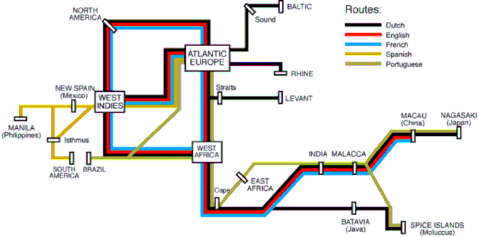
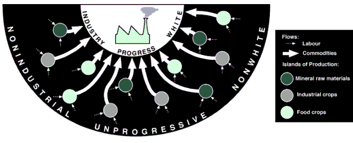
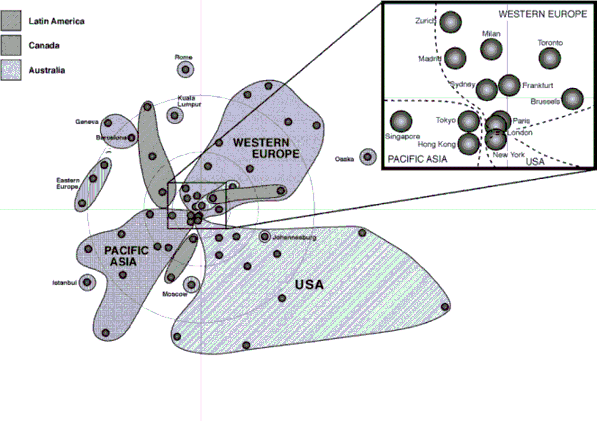
At times it seems that there are as many opinions about globalization as there are authors who write about it. This is partly a feature of the peculiarly diffuse nature of the literature on this phenomenon: business gurus, populist journalists and social theorists are all well-represented. Furthermore, globalization has entered the political arena often bringing out the worse in politicians ranging from the specific and reactive, anti-foreign xenophobia, to the more general and proactive, anti-social neo-liberalism. In fact globalization is a very modern concept, reflecting as it does the ambiguities of living in a world of massive and continuous social change. My purpose here is not to try and 'tame' the concept by offering my own narrow definition - that would destroy its authenticity - rather I seek to provide basic co-ordinates, both spatial and temporal, through which to interpret contemporary social predicaments. Globalization is inherently geographical. Hence, there has been much discussion of its spatial co-ordinates. Two particular perspectives are prominent. Most obviously globalization implies a changing scale of human activity: processes previously operating at the level of the state have been relocated 'upwards' to larger, including world-wide, patterns of operation. A more subtle argument is that globalization is associated with a fundamental change in the nature of social space: from an old 'space of places' to a new 'space of flows'. There is no need for these two geographical perspectives to be contradictory but in most studies one or other of them tends to dominate the discussion. This can usually be seen in their associated temporal co-ordinates. Treating globalization as a shift in scale allows for a 'comparative globalization' approach wherein historical 'trans-continental' societies are compared to contemporary globalization. In contrast, treating globalization as a new form of space means that there are no precedents: globalization is historically unique. I take neither of these positions here. Both can be criticized for their inability to develop an adequate geohistorical interpretation of globalization. Such an approach requires an integrated framework of time and space. This is impossible with the two perspectives described above: the comparative method elides continuities and connections, the tradition of seeing the present as unique erases continuities and connections. There is, of course, a very common geohistorical interpretation of globalization which describes a 'shrinking world'. The argument is that improving transport and communication technologies have progressively lessened the 'friction of distance' culminating with the contemporary 'end of geography' in the instantaneous organization of international financial markets. This 'space-time compression' combines elements of both the scale and flow positions - faster flows allow for larger organization - and provides important insights into contemporary social change but it is a quite limited as an argument for identifying the spatial and temporal co-ordinates of globalization. Instead of this 'whiggish' geohistory, I will develop a new argument based upon my treatment of modernities within world-systems analysis (Taylor, 1999) using the concept of metageography. Metageography is the term coined by Lewis and Wigen (1997) to describe the geographical structures through which people order their knowledge of the world. It is part of a society's taken-for granted world. Rarely questioned as to its veracity or utility, a metageography constitutes an unexamined spatial discourse that provides the framework for thinking about the world across the whole gamut of human activities and interests.1 But a metageography is not eternal. I historicise the concept through adding the idea of a moment as a critical time of transition between metageographies. This enables me to ask, does contemporary globalization constitute a metageographical moment? My route to answering this question takes in three arguments. First, I outline a geohistorical interpretation of the modern world-system in terms of metageographies. This identifies an embedded statism at the heart of our contemporary metageography. Second, I consider the nature of this metageography as an unexamined spatial discourse that has seriously distorted our contemporary understanding of the modern world-system. This identifies social science as an important victim, which, for instance, has always left 'international relations' out on a limb. Third, I consider the evidence for the erosion of the current metageography under conditions of contemporary globalization with particular reference to world cities. I conclude that globalization can indeed be interpreted as a metageographical moment; rather than representing an erosion of the state, globalization is best viewed as an erosion of embedded statism. METAGEOGRAPHIES OF THE MODERN WORLD-SYSTEMAs collective geographical imaginations, all societies will have distinctive metageographies. Well-known examples are: the traditional Chinese view of the world centered on the 'middle kingdom', the Moslem division of the world into the 'House of Islam' and the 'House of War', the medieval Christian 'T and O' map with Jerusalem at the centre, and today's world political map of 'nation-states'. These 'world maps' constitute anchors which tie each society to both physical and metaphysical worlds; they provide the spatial context which makes sense of human social activities and ideals. As such they are as much about cosmology as geography, at least in the way we interpret the latter today. The thesis developed here is that in the modern world-system, the balance between the physical and the metaphysical has altered to the detriment of the latter. From the European discovery of the Americas, through the scientific revolution, and the secularization of the state, to contemporary globalization, traditional cosmologies have been in retreat from an ongoing 'modernization' of knowledge. Following Berman (1988) I interpret modernity as indicating a state of perpetual social change which means that people living in modern society are in dire need of 'anchors', such as a metageography, to help stabilize their experiences. Since the modern world-system is the capitalist world-economy (Wallerstein, 1979), it is the material basis of geography that becomes central to how the world is viewed. But it is precisely this material basis which is the motor of the incessant change. Thus it cannot be expected that a single metageography can survive through the unfolding of the capitalist world-economy. Hence the representative of the modern world in the list of examples of metageographies above - the map of nation-states - is not the metageography of the whole of the history of the modern world-system. In the modern world there has been more than one metageography. Modernity has taken many forms over time and space since the emergence of the modern world-system in the 'long sixteenth century' (c. 1450-1650). I have argued elsewhere (Taylor, 1999) that there have been three prime modernities in the history of the modern world-system. These modern constructions with their critical systemic repercussions are associated with the world-system's hegemonic cycles. The first hegemon, the United Provinces, was largely instrumental in creating a new mercantile modernity in the seventeenth century with navigation as the key practical knowledge. The second hegemon, the United Kingdom, was largely instrumental in creating an industrial modernity in the late eighteenth and nineteenth centuries with engineering as the key practical knowledge. The third hegemon, the United States, was largely instrumental in creating a consumer modernity with media/advertising as the key practical knowledge. I argue here that each of these modernities is associated with a distinctive metageography. As spatial frameworks, modern metageographies are best identified by their geometries. The geographical metageography of mercantile modernity is a topological metageography of trade routes extending from the Philippines in the 'far west' to the Moluccas (the Spice Islands) in the 'far east'. For industrial modernity there is a centripetal metageography with the world seen as a single functional region serving a north Atlantic core. With consumer modernity there is a mosaic metageography of nation-states, national markets in which to ply wares. In each case, there is a metageographical moment when the old is eroded leaving a geographical opportunity for a new picture of the world to emerge. Like all geographies, metageographies have three aspects: pattern, content and meaning. Hence, after considering their metageographical moment I will briefly consider each metageography in turn in these terms. The topological metageography of mercantile modernityThe metageographical moment which opened up the way to the first modern metageography is the archetypal example of the process. The traditional Christian cosmology simply could not contend with the European discovery of the Americas: adding a fourth continent made an imagination limited to three continents redundant (Zerubavel, 1992). Of course, this 'discovery' also began the process that led to the famous 'triangular' Atlantic trade. At the same time, Europeans were developing routes through the Indian Ocean to the Pacific, avoiding Islam and their control of Eurasian overland routes. The end-result was that by the seventeenth century, for 'modern Europeans', the oceans represented a set of pathways linking together ports, plantations, forts, mines and way-stations into a single trading system. The topology of this metageography is shown in Figure 1. There are five main European players with the original Spanish and Portuguese trading being joined by French, English and Dutch merchants by the end of the sixteenth century. By the mid-seventeenth century it is the Dutch who dominate the overall pattern. Their success was built initially in Europe: first, the Low Countries longer-term control of the Baltic trade and, second, their successful strategy of blocking off Antwerp from the sea to give them access to the Rhineland heart of western Europe. Beyond Europe, the pattern consists of a north Atlantic triangular trading core with further linkages east and west where Spain and Portugal retain some influence. At the core of the system lay Amsterdam, the 'world's entrepot' , whose commercial calendar was organized around the return of the four great fleets from the Baltic, the Levant, West Indies and East Indies (Israel, 1989, 257-8). As well as the commodities, information arrived with the fleets and from other parts of Europe to make Amsterdam the first 'world clearing house' for commercial information (Smith, 1984). With respect to the later metageographies, the meaning of the first modern case is particularly interesting. For these first modern Europeans, the rest of the world was viewed as a cornucopia, a land of plenty from which to win great wealth. Hence there was no assumption that these other regions of the world were inferior. This is in keeping with the reality: throughout mercantile modernity, Europe was not the leading world region as Frank (1998) has so clearly demonstrated. But it was not just the traditional European awe of the 'fabulous east' which is to be found in contemporary minds, European reactions to African cities similarly show none of the later superiority complex: Benin, for instance, was compared favourably to Amsterdam (Oliver and Fage, 1988, 89-90). The first modern European metageography was only topological precisely because, beyond the Atlantic, it consisted of merely feeder paths into established Asian trading networks. The centripetal metageography of industrial modernityThe industrial revolution in north-west Europe changed the balance of power between world regions. As such it generated a metageographical moment. New production, armaments and wealth meant that militarily and economically Europeans could take over and restructure the world to suit their own ends. In effect the Atlantic triangular pattern from the topological metageography was writ large to produce world-wide European control. The victory of the British over imperial China in the first Opium War is the symbolic event which confirms the overturning of the traditional world hierarchy of east over west. The world is no longer a cornucopia which exists to profit from, it is place to be designed for industrial needs. The resulting centripetal metageography is shown in Figure 2. The pattern is extremely simple: there are just two regions, an industrial core with the rest of the world supplying its needs. The initial development of industrialization in Europe was based upon local access to coal and iron ores but, beyond these basics, raw materials further afield were soon needed. This required the creation of new production zones which came in three forms: first, minerals for the engineers (beyond traditional gold and silver to copper, diamonds, nickel, tin, zinc and later petroleum for fuel and plastics); second, industrial crops for the factories (beyond tobacco to cotton, jute, oil seed, rubber, wool); and third food crops (beyond sugar to grains, meat, fruits, drinks). Of course, these developments took little heed of existing settlement patterns so that large-scale migrant labour became the norm. Typically, each individual 'island of production' existed in a 'sea of cheap labour': it was a case of labour in from the outer periphery and commodities out to the industrial core. In this way different parts of the world became specialised in single commodities. So much so that countries came to be commonly associated with particular commodities. Well known examples are: Argentina and beef, Australia and wool, Brazil and coffee, Bengal and jute, Ceylon and tea, Malaya and rubber, New Zealand and lamb, Northern Rhodesia (Zambia) and copper, South Africa and diamonds, Sudan and cotton, and later, the classic case of the middle east and oil. The meaning of this metageography is straightforward: a simple human hierarchy has been constructed defining Europeans as superior to peoples from other parts of the world. Combined with a temporal metahistory of progress, as typified by the Whig theory of history (Taylor, 1996a, 133-6), legitimation was provided for both pro-white, scientific racism, often integrated with a pro-temperate climate, scientific environmentalism, and a virulent political imperialism with whites ruling non-whites. In becoming custodians for the unfortunate non-progressives, imperialists did attempt to make the colonies 'pay for themselves', of course, by ensuring each colony included a specialized island of production. One outcome was the celebrated world map of the British Empire showing pink areas everywhere ( Cook, 1984). Appearing on the walls of classrooms in all continents, this was the most well known expression of the centripetal metageography. The mosaic metageography of consumer modernityToday the world map found on classroom walls is more universal: it shows the boundaries of all states across the world.2 With independent states replacing empires the mosaic map is truly a post-colonial artifact. The metageographical moment from which it arose as the latest metageography is decolonisation. The first half of the twentieth century saw the gradual demise of Europe as the 'natural' locus of world leadership. Even at the height of the new imperialism the emergence of non-European world powers at the turn of the last century in the Pacific - USA and Japan - signaled a changing world hierarchy (Bartlett, 1984). Japan, in particular, as the first 'non-white/non-European' state to make an independent impact on modern world politics was symbolically important. Although legitimation of European rule was increasingly challenged, political change was much slower as reflected in the outcome of the two world wars: after World War I the area of European imperium was actually increased whereas the end of World War II marked the critical beginning of its final demise. The world political map that was formed after 1945 has been identified as fundamentally different from all previous international systems (Hinsley, 1982). Under the auspices of the UN, the only legitimate wars became wars of defence. In other words boundaries became sacrosanct. Thus. decolonisation resulted in new states within colonial boundaries. This boundary maintenance obsession has created a remarkable stability to the world political map: even the later breakup of communist states was kept strictly to existing boundary lines by always making new external sovereign boundaries out of old internal provincial boundaries. The result is a world political map which appears almost 'natural', political boundary lines (red) share a similar visual status to coastlines (black), rivers (blue) and mountain ranges (brown) on maps of the world. It is this status which creates the metageography. Metageographies are not simple political creations: delegitimating war by the UN cannot of itself make a geographical imagination. The mosaic metageography is a product of nationalism. The political boundaries do not just delimit the territories of states, they define the homelands of nations. Combining the political institution of state with the cultural attributes of nation is a nineteenth century European political invention that created nationalism as a global movement in the twentieth century. The basic nationalist claim is that nations are the natural divisions of humanity expressed through statehood (Smith, 1982). Thus nations typically 'find' primeval justification for their presence as nation-states and it is this constructed 'timelessness' which promotes the illusion of naturalness. Hence the world political map is no ordinary map, it places every viewer, through her or his nationality, within a spatial framework of humanity. The USA is, of course, the first post-colonial state. Pre-nationalist in its origins, it has developed a civic nationalism rather than an ethnic nationalism with its territory deemed to be a sanctuary for 'timeless values' (freedom and democracy) rather than for a timeless people. Hence, despite a minor foray into imperialism at the turn of the twentieth century, the USA has been able to portray itself as an anti-imperial champion. After 1945 it was able to harness the implicit democracy within nationalism to create a post-colonial 'free world' open for American business. The subsequent 'American invasion' was by 'multinational' corporations who viewed the world political map as an array of 'national markets' for production and consumption of their goods.3 The meaning of this mosaic metageography is more subtle than its forebears. Of course, political independence did not eliminate the old centripetal pattern which lived on in concepts such as 'underdevelopment', 'Third World' or simply 'South'. But the mosaic metageography incorporates an inherent sense of equivalence between states that can be expressed as an international egalitarian discourse summed up in the slogan 'development for all' (Taylor, 1996a, 136-40). In the centripetal metageography the centre experiences progress which is inherent in superior Europeans; all other civilizations are deemed to be 'stagnant'. Under American hegemony the concept of progress is replaced by development which is a matter of states not civilizations. Hence, the promise of Americanization, the American dream as world dream, is promoted as a possibility for any country as long as it employs the correct development policies.4 Originally this involved 'iron and steel works all round' as 'underdeveloped countries' attempted to replicate nineteenth century European development. But Americanization gradually converted new political citizenship into an economic citizenship or 'consumptionship' in the famous 'postwar boom' which was, of course, in line with the needs of US multinationals working in a mosaic of national markets. EMBEDDED STATISM: LIVING WITH THE LAST METAGEOGRAPHYLiving with a metageography is to be largely unconscious of its influence on our thinking and activities. Its spatial premises enter the realm of 'common sense' where interrogation is deemed both unnecessary and quite uncalled for. The mosaic metageography has fixed an embedded statism into our knowledge of the social world. This is as much true of the thinking of social scientists, who are supposed to be critically aware of their environs, as it is of society in general. Certainly there have been important recent statements warning us of the perils of unexamined territorial thinking - Ruggie (1993) in international relations and Agnew (1993) in political geography are the most influential examples. However, it is my thesis here that these warnings, while being valuable correctives, have not fully understood the intellectual and social depth of the statism which they attack. Quite simply, statism is embedded in our society through the mosaic metageography. The most common indicator of embedded statism is a collective loss of history producing intellectually lonely conceptualizations. With no past situations for company, the contemporary way of doing things comes to resemble the 'natural order' of things. This profound lack of imagination produces a world of no legitimate alternatives: nation-states are our present and our future. Such ahistorical 'common sense' can be found in current controversies on the future of national currencies. In the first section below I treat the idea of having a 'national currency' as a classic case of embedded statism, revealed as such through recovering its very recent historical construction. This argument stands as a prelude to a more general exploration of the embedded statism at the heart of the idea of there being such a thing as 'social science'. This second section reveals social science as both a creation and creature of states. The very depth of insidious state invasion into the work of those who would understand our social world is the subject of section three. The fact that the facts used to understand states are produced by states - I call them 'state-istics' - reveals the incestuous relations between social sciences and nation-states. If ever there was a situation where a 'declaration of interest' was called for then this is it. But there is no call, this arrangement is all 'common sense' within the mosaic metageography. Confusing natural with national: the case of territorial currencies5Today we associate countries with currencies: Germany and its mark, Britain and its pound sterling, the USA and its dollar, Japan and its yen and so on.6 Most people might not know that the currency of Thailand is the baht but they would expect there to be a specifically Thai money whatever their notes are called. States and currencies go together, an indicator of sovereignty and for the people a symbol of national identity. In the words of Helleiner (1999, 310) this all seems 'quite natural', how else would you expect money to be arranged across the world? In fact, any basic geohistorical consideration of money would soon show that the association of state and currency is quite 'unnatural'. Money is about transaction, about flows between places; modern states are about territories, about bounding transactions, truncating flows. Hence Helleiner terms contemporary currencies 'territorial currencies', a new form of money. Although each particular currency may have a long pedigree, their specific role today as a national currency is unique to our times. National currencies are part of the process of nation-state building. Since nation-state building progressed at different rates in different places the system of national currencies did not emerge at the same time everywhere. National currencies as we know them today were constructed in the period between the mid-nineteenth century and the first half of the twentieth century. Thus national currencies grew with and reinforced the emergence of the mosaic metageogeography of which they are archetypal artifacts. The creation of territorial currencies required two basic geographical shifts against monetary rivals. First, the removal of foreign currencies as legal tender was necessary. For instance, before national currencies, the Mexican dollar ('pieces of eight') operated as a sort of general currency across North America. This, and the use all other foreign money, was only abolished by the US government in the 1850s. Second, curtailing the issuing of local bank notes, many with only a limited range of recognition, was necessary. Helleiner (1999, 320) reports over 7,000 different notes issued in the USA in the 1850s. After the civil war this was controlled through public licensing of the banks allowed to issue notes but standardization did not come until the creation of the US Federal Reserve with its note monopoly in 1913. The latter allowed notes to represent a national currency through using propaganda in their design. But an even more important nationalization of money came with the provision of low denomination coins for the poor. This confirmed 'one nation, one money', as Helleiner (1999, 310) so aptly terms it. There was nothing inevitable about this rise of national currencies. In 1867 the French called a conference to promote a universal currency with the aim of cutting out inefficient transaction costs for international trade. This was during the high mark of European free trade but international liberalism was soon to be defeated by national protectionalism and free trade's demise took with it any hopes of a universal currency. For then, not now. The rise of the eurodollar market in the 1960s marked a return of cosmopolitan currencies, and the current establishment of the euro marks another blow to national, although not territorial, currencies. Of course, the fact of relatively recent creation does not make national currencies any less of a populist symbol to be used politically against international financial markets and imposition of transnational currencies. There is depth to this politics precisely because it is integral to the mosaic metageography: national currencies have been embedded in our geographical imaginations. Social unitarianism, spatial congruence and the social science trinity7Although, there is a long tradition of pondering the relations between people, peoples, and their environments, social science is a relatively recent invention. As an idea it is a product of the nineteenth century but it only came to full fruition as acceptable disciplinary knowledge in universities in the twentieth century. It was constructed on the frontier between the much more established knowledges of natural science and the humanities. Based on the simple premise that it was possible to use the methods of the former to study the subject matter of the latter, social science was developed initially under the pervasive influence of social progress and reform. Originally there was a flowering of new separate social knowledges in orthodox political economy, positivist 'social science' and liberal political philosophy. This early social science directly reflected the centripetal metageography of its time. Its theories and models were only designed as applicable to 'industrial society'; the rest of the world, being non-progressive, was intellectually uninteresting and left largely to the curiosity of anthropologists, human geographers, Orientalists and their ilk. Subsequently political economy has transmuted into economics, positivist 'social science' into sociology, and political philosophy into political science. Although building upon European antecedents, this 'trinity' of contemporary social sciences was finally created and promoted through American academe in the mid-twentieth century. I use the word trinity here not just in the quantity sense but to indicate a collective mutuality. All three disciplines have maintained some of their forebears' broader knowledge claims but essentially they have become more specialised concentrating on 'economy', 'civil society' and 'politics' respectively. And this is where the mutuality comes in: between them they claim to study all social relations leaving no intellectual space for other disciplines. The social science trinity also captured all geographical space for themselves. As the centripetal metageography declined so the old 'non-industrial' disciplines such as anthropology began to lose influence in the realms of academe. With the coming of the new mosaic metageography, the trinity was expected to provide knowledge of all countries equally; it obliged by simply transferring knowledge derived from 'developed' countries to 'underdeveloped' countries. The result was the creation of a variety of modernization and development theories for, but not of, 'third world' states. And, of course this new social unitarianism extended to time. Taking a particularly narrow view of the science it was importing into the study of human activities, twentieth century social science at its worst offered timeless and spaceless knowledge based upon universal theory. But there was a hidden premise in this universal theory. Embedded statism contains the remarkable geographical assumption that all the important human social activities share exactly the same spaces. This spatial congruence can be stated simply: the 'society' which sociologists study, the 'economy' which economists study, and the 'polity' which political scientists study all share a common geographical boundary, that of the state. However abstract the social theory, it is national societies which are described; however quantitative the economic models, it is national economies which are depicted; and however behavioural the political science, it is national governance at issue. From a geographical perspective the trinity provides 'one scale' social knowledge as directed by the mosaic metageography. This scale bias can be best shown in studies that deal with more than one state. The norm has been to cultivate comparative analyses rather than relational ones. In comparative sociology or comparative politics, for instance, the UK might be compared with France but with little concern for how the two countries actually relate to each other. For studying relations between states, there has emerged a special discipline of international relations (IR) which in its dominant 'realist' manifestation claims to be beyond social science. Its international anarchy assumption proscribes finding relations other than war and preparation for war. Hence the realm of human social activities above the state are either ignored in social science or deemed to be asocial (IR). There is one important exception, trade theory in economics. This was central in traditional political economy but it has been marginalised in the more specialist economics discipline where it plays the role of a timeless and placeless mantra for promoting free trade. There are, of course, many good reasons for developing social knowledge at the scale of the state. The rise of the mosaic metageography is part of the rise of states as the prime actors in social affairs. No longer just remote vehicles for collecting taxes to fight wars, in the nineteenth and twentieth centuries states grew immensely in relating to their citizens, from 'cradle to grave' as the saying goes. This is the nationalization of states previously discussed. For instance, national currencies led to central banks through which national governments could pursue macroeconomic policies of demand and/or supply management in the national economy. Clearly any meaningful social knowledge of these times must have the state as a prime subject. But if it is to be a critical social knowledge it must also appreciate that the nation-state is much more than a subject. Embedded statism implies the trinity has failed in this respect; the state is unexamined at the very heart of the project, how the knowledge is organized. State-istics and anal-ysis8With the demise of cosmologies, social knowledge has become fundamentally evidential. Hence the nature of the data is crucial, it helps define the organization of the knowledge. The common term for social data is 'statistics' a term which derives directly from the word state. This is, of course, no accident: large scale data collection on human activities has its origins in state needs and continues to be dominated by states. Hence my portrayal of it as state-istics. Like all scientists, social scientists collect data. However, within social science there is little or no 'big science' where very large sums of money are committed to solving theoretical problems. The latter enables scientists to concentrate on developing measurements specifically designed for their theoretical purposes. In social science, most data that is collected relates to small-scale cumulative scientific activity. To get an evidential handle on big issues, researchers normally rely on the statistics that are available, that is to say, already collected. Collection is carried out usually by a state agency for the particular needs of government policy, not, of course, for social science research. But the problem is much more than the possibility of having to use unsuitable data. Basing 'big social science' on state-istics means that the state defines the basic dimensions of the leading edge 'macro' social research and therefore the framework within which most social research is conducted. This is clearly demonstrated in the dominance of attribute measures over relational measures in social research. Measurement can take one of two forms: attribute measures on objects or relational measures between objects. The needs of social science and the state diverge at this very starting point. All theory about human social activities is basically about relations between individuals, groups and other human collectivities. Therefore the data need is for relational measures, of flows, connections, linkages and other less tangible relations. The prime concern of the state for data has always been accounting, finding out numbers of phenomenon within its territory or parts thereof. Thus the vast majority of statistics are lists of attributes by place as any quick browse through a census volume will confirm. But social scientists rely on these state-istics and they have used intelligent ways of getting round the attribute bias. For instance, a dynamics without relations is defined commonly in terms of changing attribute measures across a set of census dates. More sophisticated still, relations themselves are redefined as not between objects per se but as occurring between the attribute measures on the objects. The whole toolbox of mathematical statistics on co-variation has been developed to cover this sleight of hand. Finally it should be noted that through its association with the state the social science trinity has created another critical dominance, that of analysis over synthesis. There are many reasons for this ranging from the problem-solving reform origins of much social knowledge through to simple emulation of supposed 'scientific analysis'. Certainly analysis became institutionalized through expectations of journal editors and peer referees, and consequently through the reward mechanisms within universities. Analysis also directly reflected the nature of the trinity in being a division of social knowledge eschewing traditional social synthesis. The more synthetic disciplines, such as human geography, were those which declined with the centripetal megageography. In fact, in order for the minor disciplines to survive, synthesis had to be abandoned and analysis, in the form of the trinity, internalized into their disciplinary organization. Thus the adjectives social, economic and political have been added to anthropology, geography and even history in the twentieth century to define new 'subdisciplines' to guard against the danger of resurgent synthesis. The subdisciplines have become vehicles of analysis and as such contributed, albeit in a minor way, to constructing the unitarian modernization and development models thus betraying their disciplinary origins. Embedded statism works in mysterious ways, but it is not universal. Dependent on the mosaic metageography, the trinity's demise will be nigh when with the next metageographical moment. CONTEMPORARY GLOBALIZATION AS A NEW METAGEOGRAPHICAL MOMENTA metageographical moment defines a transition in our collective geographical imagination. It marks the disintegration of an existing metageography and provides the opportunities to create a new metageography. It is not, of course, instantaneous, but there should be a clear-cut change in the way the world is viewed and interpreted. Thus, if we are considering the present as a metageographical moment we should be searching for evidence of an erosion of embedded statism, of a serious decline in acceptance of the state as the 'natural' locus of power across the gamut of human social activities. At even the most cursory level of consideration, globalization seems to fit the bill as a metageographical moment. At its heart most of the debate about globalization has been concerned with the future of the state. For instance, David Held and his colleagues (1999, 2-10) align positions on globalization along a spectrum with the 'hyperglobalists' at one end and the 'sceptics' at the other. The former define a 'global age' and the end of the state, the latter enhanced 'internationalization' with states remaining as key actors within regional blocs. In between are the 'transformationists' who accept the unprecedented levels of global interconnectness but view this as transforming state power not eliminating it. Part of the problem with this argument is that the debate was set by the hyperglobalists which has produced a global versus state agenda. The transformationalists try to free themselves from this simple opposition but in doing so they deal more with the transformation of the state than global transformation itself (Taylor, 2000). In contrast, my starting point is the question of the geographical scale at which human social activities take place. Alternative spacesThere is one thing all positions in the debate are agreed upon: there have been changes in the pattern of geographical scales at which human social activities are organized. To be sure the degree of change is in dispute but even the sceptics challenge the simple one-scale pattern of human organization ensconced in the mosaic metageography. Recognizing new internationalization and the future importance of regional blocs is a long way from leaving the 'international sphere' to the asocial study of international relations. This focus on supra-national institutions, which is shared by the transformationalists, can be interpreted in two different ways. Either there is a new multi-scalar organization of human social activities where the state remains an important, perhaps still the most important, scale, or the new regional institutions, with perhaps the European Union leading the way, are producing a new larger regional scale of human social organization. The latter would create a new mosaic geography with a reduced number of 'pieces', reversing the proliferation of states which characterized the twentieth century. Whichever position is taken, however, the thinking remains territorialist in nature with boundaries continuing to feature prominently. This is a continuation of the boundary obsession found at the heart of the mosaic metageography. Hence depicting globalization as supranational suggests a relatively moderate transition in a contemporary metageographical moment. Instead of supra-national institutions, I think it more efficacious to focus on the transnational processes within globalization. Boundaries are about truncating flows, and this is precisely where states are being challenged as new technologies have made policing borders more difficult than ever before. The worldwide web is, in old terminology, a 'smuggler's charter'. This is not to argue the hyperglobalist position of a 'borderless world', but is does mean that transnational processes can undermine the mosaic metageography much more completely than supranational institutions. The best conceptualization of this change comes from Castell's (1996) in his identification of a contemporary 'network society'. He contrasts the 'space of flows' which constitutes the latter with the 'space of places' which proceeded it. According to Castells, before the 1970s society was organized territorially, as reflected in the mosaic metageography, with agriculture, industry and services areally based in local and national economies. All this changes with the coming of the 'informational age' where new enabling technologies combining communications and computers provide the potential for new transnational projections of power. This was first recognized in the early 1970s as multinational corporations were found to have 'global reach' and economic clout greater than many individual countries (Barnett and Muller, 1974). At about the same time the international financial market 'took off' so that by the 1980s it dwarfed all national finances. Government control of finances sealed by the institution of central banks was put back into doubt. The end result is a global space of flows in an economy where success is based on access to information. This interpretation of globalization is self-evidently an extremely radical challenge to the material basis of the mosaic metageography. While using Castells' argument to categorize contemporary globalization we do not have to share his geohistory. As Arrighi (1994, 84) has clearly shown, international financial flows transcending states have been a cyclical phenomenon in the capitalist world-economy. Hence critical systemic 'spaces of flows' precede the 1970s. Interestingly, Arrighi suggests that Castells misses earlier spaces of flows because he is a victim of embedded statism in his treatment of pre-1970 spaces.9 For Arrighi spaces of places and spaces of flows have developed simultaneously in the modern world-system although they will vary in relative importance at different times. This is, of course, what my sequence of metageographies described previously suggests. The initial topological metageography clearly represents a space of flows, the centripetal metageography describes a mixture of the two types of space, and the mosaic metageography is a space of places. Returning to Castells, it would seem that globalization has reversed this metageographical trend to a more territorial geographical imagination in a move back to a space of flows. World cities in a network metageography?For Castells (1996, 415) world cities constitute the 'most direct illustration' of the nodes and hubs in his global space of flows. Of course, it has always been the nature of cities to be the nodes in networks of flows. Hence, we have to ask again whether Castells' identification of a unique present, world cities operating in a 'global network' of cities (p. 380), is indeed singular. Certainly there have been large-scale networks of ports which long predate the modern world-system. The emergence of the latter produced its own port network as depicted in the topological metageography. 'Atlantic Europe' in Figure 1, for instance, is constituted of the great port cities of Amsterdam, London, Bordeaux, Lisbon, Seville. Bristol, Rotterdam, Le Havre and so on. Furthermore, there have been great international financial centres in the modern world-system - Arrighi (1994) lists Genoa, Antwerp, Amsterdam London and New York in chronological order. For Braudel (1982) these were 'world-cities' in the sense of being the leading city of their respective eras with system-wide influencies. Today, following the work of Sassen (1991), it is usual to identify three 'global cities' - London, New York and Tokyo - as leading world cities: Castells places them at the top of his hierarchy (p. 380) for example. This putative 'shared leadership' is not necessarily unusual since singular world-city leadership historically declines in line with hegemonic cycles. But the global spread of leading cities, straddling the world's time zones in a financial market that never closes, does represent a new scale of financial activity. But does this globalization represent a genuinely new urban system? I am going to answer this question positively because the economic restructuring associated with globalization has enhanced the role of cities to an extraordinary degree. The informational age has favoured the growth of economic sectors where knowledge (i.e. how you use information) is a key component of production. In advanced service sectors, of course, knowledge is the product. Hence the tradition role of cities as 'service centres' has meant that the major cities who provide corporate services have prospered outstandingly with globalization. These advanced producer services (such as accountancy, advertising, banking/finance, insurance, management consultancy, law, etc.) have 'gone global'. Initially, this locational expansion was necessary to serve their multinational corporation customers but subsequently service firms have developed their own global strategies. Making full use of the enabling communication technologies, advanced producer service firms themselves created a cutting edge global industry. Hence, service firms, traditionally associated with a client-base in a single city, have become global corporations. But to stay at the cutting edge they have to be located where large quantities of the most up-to-date information intersects with clusters of advanced 'professional/creative' expertise to make new customized knowledge products (Sassen, 1991). This means that to be a successful player in the field, a global service firm has to have an array of offices in world cities across the globe. Collectively, the many global firms with multi-city networks of offices collectively have produced the contemporary world city network (Taylor, 2001). The Globalization and World Cities (GaWC) research team at Loughborough University has been experimenting with first, how to identify world cities and second, how to locate them in a world city network. Identification was carried out using data on 71 service firms which created an inventory of 55 world cities at three levels of service provision; ten alpha world cities (including Sassen's three 'global cities'), ten beta world cities, and 35 gamma world cities (Beaverstock, Smith and Taylor, 1999). The distribution of these cities shows three distinct clusters centred on northern America, western Europe and Pacific Asia: globalization is certainly not an even geographical process. Rather than simple location, hoever, emphasis in a network society should be on the connections between cities. In Figure 3 a 'global corporate service space' has been constructed by computing the connections between cities among 46 major service firms with offices in more than 15 cities. Inverting similarities in profiles of firms between pairs of cities to produce 'functional distances' (i.e. the more similar two cities are, the smaller the 'corporate service distance' between them), enables us to use multi-dimensional scaling to define the new space Taylor et al. 2000). And as Figure 3 shows, the space is highly centric in nature with the major alpha cities at the centre and lesser world cities relegated to a periphery. However, there is also a distinctive regional pattern with the three main globalization arenas easily discernable. This new world map represents a unique 'visualization' of the modern world-system as a network of cities linked together in a mixture of hierarchy and regionality.. We come now to the question posed in the title of this section: can/will the world city network constitute a new metageography in keeping with contemporary globalization? The answer to 'can' is obviously yes, with the disintegration of the mosaic metageography as described earlier, the opportunity exists for the making of an alternative collective geographical imagination. But this is not a simple and quick switch. In answer to 'will' our confidence must be highly circumscribed. As things stand at the moment, cities appear to be the most likely candidates to threaten the primacy of states as the building blocks of a spatial framework of the world. As well as the economic trends described above, there are political developments enhancing the status of cities notable the widespread promotion and adoption of 'strong mayor' forms of city government. Elections to such posts may be instrumental in the disintegration of national party systems. But there are, as yet, little or no evidence of a transfer of primary allegiance or identity from state to city. Figure 3 is presented as merely indicative of the possibility of a new network metageography. Transdisciplinary social scienceNetworks and boundaries are uneasy bedfellows and therefore we can expect the scope of great cities to be truncated by the world of boundaries created by nation-states. But the mosaic metageography has created an additional penalty: cities have been major victims of embedded statism. In urban studies relations between cities have been conceptualsed as 'national city systems' or 'national urban hierarchies'. In other words, relations are modeled as stopping at the state border: for instance New York is conceived as an American city and not a world-city. Of course, given the nature of state-istics, even these truncated inter-city relations usually remain at the conceptual level only; measures of flows, connections or linkages are conspicuously missing. Studies of cities are usually comparative and focus on demographics because that is what census data provides: it is what states need to know in their accounting. Focusing on the population sizes of cities has generated a tradition of research on 'urbanization' which is patent anti-city in perspective. Cities are portrayed as a problem for their geographical neighbours rather than as the economic and cultural opportunities which is the reality. At the global level this has led to a focus on large mega-cities and the problems they pose. Of course, 'big cities' are easily identified, all that is needed is a population threshold and census figures from the appropriate countries (actually the data is brought together in UN publications). In contrast just try and find meaningful data on the relations between London and New York, the two leading world cities. There are no, I would go as far as to say there can be no, state-istics on such important information; the GaWC work described above is largely about trying to construct such inter-city measures and official data never enters the equation. This brief indictment of the treatment of cities through embedded statism means that we cannot expect the trinity of social sciences to have made much contribution to the idea of cities as the crossroads of society. Within the social sciences cities have mainly constituted problems with much use made of attribute measures in the 'census tract' research tradition. But there is a positive side to urban studies. As an alternative way of organizing social knowledge, this type of area study shows a potential for a more synthetic approach - seeing the city as a whole (albeit shorn of its external relations). A similar effect is found with regional area studies where, for instance, an Africanist cannot be narrowly political or economic or social. However, in practice, these fields of study never achieved the prominence or status of the trinity disciplines. Throughout the life of the mosaic metageography, the domination of the trinity on social knowledge was not in doubt: the spatial entity was the nation-state and the methods were analytical. But how far is the trinity dependent on embedded statism? How will they fare as the latter is eroded? The trinity has not been able to handle globalization very well (Taylor, 1996b). But globalization has hardly been neglected in social research. What has happened is that there has been a flowering of transdisciplinary studies which have coped quite well in the new circumstances. The field of cultural studies is a typical example. With its roots in traditional anthropology, it has developed on the interface between the humanities and social science to become one of the most vibrant sources of ideas about globalization. Notice that I have referred to it as a 'field' rather than a discipline. In studying globalization, narrow specialization, especially with theory embedded in statism, is a disadvantage for understanding the new processes. Another field is business studies. While the discipline of economics continues to tell us about national economies (or 'the economy' as they would refer it), business schools across all continents have emerged from their 'management' origins to provide eclectic research agendas on the world-economy and globalization. The emergence of IPE (international political economy) out of IR (international relations) is particularly instructive in this context. Led by Strange (1988) and her campaign against narrow disciplinary approaches,10 it became clear to a new school of researchers that international politics and international business could not sensibly be studied in isolation of each other. Obviously boosted by the end of the Cold War and the more transparent nature of international economic competition in the 1990s, nevertheless pioneers of this school predate this change with their initial 'states and markets' approach. Although keeping the term 'international' in its title, IPE has become a very heterodox body of knowledge. As well as the original school largely derived from IR, there has been a revival of pre-embedded statism knowledges such as institutional economics (e.g. on the social constitution of markets) and the creation of new knowledges such as world-systems analysis (e.g. on global commodity chain analysis and world cities) which can all find a place under this intellectual umbrella. There is a new common sense: heterodoxy and eclectism are necessary in new circumstances where no disciplines can claim a monopoly of social knowledge. Transdisciplinary knowledge is required to study transnational processes. REFERENCESAgnew, J. (1993) 'The territorial trap', Review of International Political Economy 1, 53-80 Arrighi, G. (1994) The Long Twentieth Century London: Verso Bartlett, C. J. (1984) The Global Conflict, 1800-1970 London: Longman Beaverstock, J. V., Smith, R. G. and Taylor, P. J. (1999) 'A roster of world cities', Cities, 16, 445-58 Berman, M. (1988) All that is Solid Melts into Air New York: Penguin Castells, M. (1996) The Rise of the Network Society. Oxford: Blackwell Cook, T. (1984) 'A reconstruction of the world: George R. Parkin's British Empire map of 1893", Cartographia 21(4), 53-65 Frank, A. G. (1998) ReOrient Berkeley: University of California Press Held, D., McGrew, A., Goldblatt, D. and Perraton, J. (1999) Global Transformation Cambridge: Polity Helleiner, E. (1999) 'Historicizing territorial currencies', Political Geography 18, 309-40 Hinsley, F. H. (1982) 'The rise and fall of the modern imternational system', Review of International Studies 8, 1-8 Israel, J. I. (1989) Dutch Primacy in World Trade, 1585-1740 Oxford: Clarendon Lewis, M. W. and Wigen, K. E. (1997) The Myth of Continents. Berkeley: University of California Press Oliver, R. and Fage, J. D. (1988) A Short History of Africa London: Penguin Ruggie, J. (1993) 'Territoriality and beyond', International Organization 47, 139-74 Sassen, S. (1991) The Global City. Princeton: Princeton University Press Slater, D. and Taylor, P. J. (eds.) (1999) The American Century London: Routledge Smith, A. D. (1982) 'Ethnic identity and world order', Millennium 12, 149-61 Smith, W. D. (1984) 'The function of commercial centres in the modernization of European capitalism', Journal of Economic History 44, 985-1005 Strange, S. (1988) States and Markets London: Pinter Strange, S. (1996) The Retreat of the State Cambridge: Cambridge University Press Taylor, P. J. (1996a) The Way the Modern World Works New York: Wiley Taylor, P. J. (1996b) 'Embedded statism and the social sciences: opening up to new spaces', Environment and Planning A, 28, 1917-28 Taylor, P. J. (1997a) 'The crisis of boundaries: towards a new heterodoxy in the social sciences', Journal of Area Studies,11, 11-31 Taylor, P. J. (1997b) 'Hierarchical tendencies amongst world cities: a global research proposal', Cities, 14 , 323-32 Taylor, P. J. (1999a) Modernities: a Geohistorical Interpretation Cambridge: Polity Taylor, P. J. (2000) 'Embedded statism and the social sciences 2: geographies (and metageographies) in globalization', Environment and Planning A, 32, Taylor, P. J. (2001) 'Specification of the world city network', Geographical Analysis, (in press) Taylor, P. J., Hoyler, M., Walker, D.R.F. and Szegner, M. J. (2000) 'A new world map for the new millennium', GaWC Research Bulletin 30 Wallerstein, I. (1979) The Capitalist World-Economy Cambridge: Cambridge University Press Zerubavel, E. (1992) Terra Cognita: the Mental Discovery of America New Brunswick: Rutgers University Press
NOTES1. My favourite example of the over-powering influence of a metageography comes in nature books where animals and plants are 'nationalised' as in 'British Trees' or British Insects'. This represents the power of what I call below a mosaic metageography based upon nation-states. There are even books on 'British Birds' even though many are migratory and spend much of the year either far north or far south of Britain. 2. Since this is the metageography with which all readers will have grown up, and continue to carry around in their heads, unlike the previous cases I have no need to use a figure to show this geographical imagination. 3. For elaborations on this, see Slater and Taylor (1999). 4. This is, of course, the message of Rostow's (1960) most famous development ladder in a 'non-communist manifesto. 5. This section draws heavily on the argument in Helleiner (1999). 6. Of course, this situation has been recently highlighted by the creation of the euro replacing national currencies in most of the EU. In the resistance to this move, critics have betrayed a remarkable statism in their argument that their territory (e.g. the UK) needs flexibility in its fiscal management while omitting to notice its own fiscal penalties imposed on sub-regions (e.g. the north of England where extra unemployment is deemed necessary to dampen inflation in the south of England). 7. This section draws from and builds upon Taylor (1996b) and (2000). 8. This section draws from and builds upon Taylor (1997b). 9. He does not use the phrase embedded statism but identifies it clearly as 'the bias of our conceptual equipment in favour of space-of-places that defines the process of state formation'. 10. She attempts to subvert 'the exclusivity of the "disciplines" and sub-disciplines of social science..(because) . our times no longer allow us the comfort of separatist specialisation in the social sciences, and . the attempt has to be made at sythesis and blending ..' (Strange, 1996, xv-xvi). Figure 1: The topological metageography
Figure 2: The centripetal metageography
Figure 3: Global corporate service space
Edited and posted on the web on 20th September 2000 Note: This Research Bulletin has been published in MA Tétreault, RA Denemark, KP Thomas and K Burch (eds) (2003) Rethinking Global Political Economy: Emerging Issues, Unfolding Odysseys London: Routledge, 46-64 |
||