GaWC Research Bulletin 319 |
|
|
|
This Research Bulletin has been published in Political Geography, 29 (1), (2010), 17-27. doi:10.1016/j.polgeo.2009.12.002 Please refer to the published version when quoting the paper.
To govern it is necessary to render the visible space over which government is to be exercised. And this is not simply a matter of looking: space has to be represented, marked out. The issue is not how and whether to draw lines around regions but to seek to understand the process through which they are (re-)produced. IntroductionThrough most of the twentieth century national economies were described in regional terms to inform policy needs that were essentially territorialist in nature: in Castells' (1996) thinking this was the national economy as a space of places'. In the United Kingdom this culminated in the Labour Government's programme of Devolution and Constitutional Change (1997-1999), which saw the establishment of a new parliament in Scotland, elected assemblies in Wales and Northern Ireland, an assembly with elected mayor in London, and (to work alongside Government Offices for the Regions) regional development agencies (RDA) and indirectly-elected regional assemblies in each of the eight English regions. To many keen observers, this signalled the UK Government's intent to reverse the trend of centralisation and embrace the popular belief that political - economic dividends could be secured by devolving state power to elected regional bodies. That is everywhere except England. In part a reflection of the logic that has seen regions reified as active agents in wealth creation, but more directly a distinct lack of civic regionalism, England has remained the only country of the UK not to be in receipt of additional elected political representation, and by implication, new institutional spaces through which to secure the promise of increased accountability and participatory democracy under devolution. This is not to say that attempts have not been made. In 2002, for instance, the UK Government presented the English regions with the opportunity to establish directly-elected regional assemblies (ERA) a proposal unanimously rejected by voters in the first and only referendum held on 4 November 2004 in North East England. Other solutions afforded a political hearing include calls for an English Parliament, English votes on English laws, English independence, strengthened local government, elected mayors, a return to ERAs sometime in the future, regional ministers, and city-regions (Hazell, 2006). Of these it is noteworthy how city-regions and city-regional thinking have become central to recent political praxis in England. First, the rhetoric surrounding city-regions is explicitly couched in a language extolling the virtues of competitiveness, and, as a result, city-regions were the only solution not to focus on providing a potential solution to the missing politics of regionalism in England (Office of the Deputy Prime Minister, 2003, 2004). Second, the focus on city-regions reflects moves away from thinking the UK economy as a space of places' towards spaces of flows' approaches that privilege cities (as key nodes) in the space economy (Castells, 1996; Scott, 2001; Taylor and Knox, 1995). Third, city-regions are seen to support calls from academics advocating thinking space relationally', for whom emergent spatial configurations are not necessarily territorial and scalar but constituted through the spatiality of flow, porosity, and connectivity (Allen and Cochrane, 2007; Allen et al., 1998; Amin, 2004; Amin et al., 2003; Massey, 2004, 2007). And fourth, the centrality of city-regions to recent political praxis means that the map of the UK space economy is no longer simply divided into administrative regions, but records the emergence of new' relationally networked spaces, some of which cut across the territorial map that prevailed through the twentieth century. All of which intensifies the urgent need to further explore the ongoing transformation of economic governance within capitalist states. But it also prompts the need to confront searching questions regarding the production and reproduction of these new state spaces' (Brenner, 2004; MacLeavy and Harrison, 2010). For despite a rich and varied literature on city-regions and city-centric capitalism, the city-region remains an object of mystery' (Harrison, 2007). Defined in economic terms (travel to work areas, functional economic ties, labour market geographies) all too often what is missing is how city-regions are constructed politically, and second, the processes by which they are rendered visible spaces. While recent interventions have done much to advance debates on the former (International Journal of Urban and Regional Research, 2007), work on the latter remains preoccupied with the increased visibility of city-regions within political discourse often framed as part of a wider neoliberal agenda (Harding, 2007). What is missing is due consideration of the political-economic struggle to spatially define, delimit and designate city-regions. Here city-regions are all too often scripted unreflectively, with little regard for how they have been historically constructed, culturally contested and politically charged1. This paper aims to explore these tensions through an examination of recent endeavours to construct a spatial map of city-regions in the north of England. Following a brief introduction to what has become known as the new city-regionalism', this paper engages, albeit selectively, with ongoing debates in human geography on the conceptualisation of state space (as relational, networked, and topological, as well as or instead of, territorial and scalar) to uncover how city-regions are made visible spaces. It does so by drawing on the experience of England, where struggles to construct a spatial map of city-regions has exacerbated the already strikingly uneven geographies of the UK following the devolution of powers, authority and legitimacy to regional institutions at the end of the twentieth century. Throughout the discussion in sections three and four, the aim is to demonstrate how the processes by which city-regions are represented and marked out are the outcome of both relational economic processes and political claims to territory. The final section relates these findings to ongoing debates around state, space and scalar geographies, and speculates what they might mean for the future of city-regional debate. The New City RegionalismNew Economics of City-Regions, New Politics of City-RegionalismAlbeit enjoying a rich scientific history, the concept of the city-region has been rejuvenated as part of a wider new regionalist' literature documenting the importance of place-based and site-specific nodes of dense economic, social, and political activity within a globalizing world (Amin and Thrift, 1992; Scott, 2001). Seen to have a deepening role' in the economy as places where globalization crystallises out on the ground (Scott, 2001a), city-regions are trumpeted as windows of locational opportunity' for capturing, nurturing, and anchoring wealth creating activity (Scott and Storper, 2003). Alongside this, claims that capitalist economies are best regulated and governed in and through the decentralisation of socioeconomic decision-making and policy implementation to city-regional institutions, frameworks and supports has rendered the task of devising city-regional policies an officially institutionalised task through North America, Western Europe, but large parts of Pacific Asia and Latin America also (Herrschel and Newman, 2002; OECD, 2007; Segbers, 2007; Simmonds and Hack, 2000; Zhao and Zhang, 2007). Despite the centrality of the city-region to modern-day accounts of economic success, those seeking to engage with these claims have been quick to highlight the need to consider several important issues. These include: the continued significance of national state power in city-region development (Harrison, 2007; McGuirk, 2007); connections between the economic geographies of cities and regional economic development (Deas and Ward, 2000); the conflict between securing economic competitiveness and managing the everyday politics of collective consumption and social reproduction in city-regions (Donald, 2001; Jonas and Ward, 2007a); the link between city-regions and the politics and outcomes of uneven development (Etherington and Jones, 2008); the dangers of policy transfer and policy imitation (Harrison, 2007; MacLeod, 2001; Ward and Jonas, 2004); and, questions around democracy (Purcell, 2007), governance (Brenner, 2002; Harrison, 2008; Leibovitz, 2003) and spatial planning (Goodchild and Hickman, 2005; Tewdwr-Jones and McNeill, 2000). All issues that could be usefully grouped as relating to the political-economy of city-regions, most recently these concerns have been voiced in a special debates forum on city-regions. Expressing concern at how discourses pertaining to a new city-regionalism are being constructed around a narrow set of empirical and theoretical issues relating to exchange, interspatial competition, and globalization the new economics of city-regions Andrew Jonas and Kevin Ward (2007a) denote how there has been a tendency to reify the city-region as an agent of wealth creation and redistribution. Overlooking how city-regions are constructed politically', this myopia heightens intellectual urgency around the need to conceptualise the (re-)emergence of city-regions as the product of a particular set of economic, cultural, environmental and political projects, each with their own logics to discover for which interests city-regions are necessary and for whom this new territoriality is merely contingent (p. 176). Not surprisingly, this claim sparked a flurry of research aimed at developing a new politics of city-regionalism (Jarvis, 2007; Krueger and Savage, 2007; McCann, 2007; McGuirk, 2007; Purcell, 2007). However, this broader, more political vision has not been welcomed by all. Alan Harding (2007), for instance, argues that for city-regions to be taken seriously there needs to be considerably more economics' in the political-economy of city-regions, while doubts persist more generally about the debilitating effect that a polarisation of the political and economic can and will have on advancing city-regional debate. Despite recent interventions doing much to raise awareness of how city-regions are being constructed politically, the processes by which city-regions are rendered a visible space are largely ignored. Here t he lack of a commonly accepted definition for the city region is indicative of a debate beset by confusion. Wherever you look in the literature a different set of criteria is used to define the city-region. Tewdwr-Jones and McNeill (2000: 131), for instance, define the city-region as a strategic and political level of administration and policy-making, extending beyond the administrative boundaries of single urban local government authorities to include urban and/or semi-urban hinterlands. For Scott (2001b: 814) city-regions constitute dense polarised masses of capital, labour, and social life that are bound up in intricate ways in intensifying and far-flung extra-national relationships. As such, they represent an outgrowth of large metropolitan areas or contiguous sets of metropolitan areas together with surrounding hinterlands of variable extent which may themselves be sites of scattered urban settlements. And for the UK Government, the city-region is a functionally inter-related geographical area comprising a central, or core city, as part of a network of urban centres and rural hinterlands. A little bit like the hub (city) and the spokes (surrounding urban/rural areas) on a bicycle wheel (Office of the Deputy Prime Minister, 2005: no pagination). Put bluntly, even for its proponents the city-region is a fuzzy' concept (cf. Markusen, 1999). What appears as the key point in most definitions though is this focus on the reach' or footprint' of cities. A recognition that gives credence to those advancing spaces of flows' approaches, it is somewhat surprising then that the spatial grammar associated with relational thinking is omitted from calls to conceptualise city-regions as the product of both economic and political projects (Jonas and Ward, 2007a). Of note is how key terms such as connectivity, flow, porosity, proximity, relational, and topology are deployed sparingly in the debates forum while reference to (and derivatives of) territory and scale are found in abundance. All of which might suggest that the spatial grammar associated with thinking space relationally' relates more appropriately to economic flows (the economics of city-regions) than it does to acts of political mobilization (the politics of city-regionalism)? Conceptualising City-Regions: Both Networked and TerritorialThe suggestion that spatial configurations are constituted through the spatiality of flow, porosity and relational connectivity has prompted, amongst others, Ash Amin (2004: 36) to theorize how in a relationally constituted world capital accumulation and governance is increasingly about exercising nodal power and aligning networks at large in one's own interest, rather than about exercising territorial power [for] there is no definable regional territory to rule over. A focus on actors, institutional structures and their interactive power relations has seen relational approaches decentre and destabilise spatial and scalar categories (such as the state, city, and region) and led to claims that human geographers should abandon notions of scale altogether (Marston et al., 2005). While these authors are inclined to jettison territorial and scalar approaches, others contend that relational/topological and territorial/scalar approaches should be seen as both/and rather than either/or conceptions (Hudson, 2007). Here the degree to which one interprets cities or regions as territorial and scalar or topological and networked remains an open question: a matter to be resolved ex post and empirically rather than a priori and theoretically (MacLeod and Jones, 2007: 1186). From this perspective, relational approaches are seen to be at their most convincing when focusing on the spatiality of cross-border economic flows and interchange, but bend the stick too far' when it comes to acts of political mobilisation, which are often territorially articulated' (Jones and MacLeod, 2004). Points that lead Martin Jones and Gordon MacLeod (2004) to usefully distinguish between new regional spaces' and new spaces of regionalism' the former referring to the production of regional difference by economic processes, the latter to processes of political mobilization around notions of regional difference. Today, a standoff exists between those who remain steadfast in their view that the spatial grammar of flows and networks is equally applicable to issues of politics as they are economics (Allen and Cochrane, 2007; Amin et al., 2003; Massey, 2005, 2007) and those calling for a retention of territorially oriented readings of political economy and when appropriate their conjoining with non-territorial, relational, and topological approaches (Hudson, 2007; Jessop et al., 2008; Jones and Jessop, 2010; MacLeod and Jones, 2007; Morgan, 2007). Noticeable, however, is that these entrenched positions are already the subject of some refinement in response to the emergence of new city-regional spaces and the relational language of network and flow that has accompanied them. John Allen and Allen Cochrane (2007: 1163) argue, for instance, that the reinvented regional' politics of south east England exposes how the governance of regions, and its spatiality, now works through a looser, more negotiable, set of political arrangements that take their shape from the networks of relations that stretch across and beyond given regional boundaries, thus calling into question the usefulness of representing regions politically as territorially fixed in any essential sense. However, Kevin Morgan's insightful observations on the UK's emerging polycentric state' suggest different:
Morgan (2007: 33 original emphasis) With so much intellectual energy being invested in attempts to capture the political-economic processes responsible for the (re)production of new state spaces, it is at best surprising, at worst alarming, that for the most part these endeavours are overlooked by those proclaiming intellectual urgency around the need to conceptualise the (re-)emergence of city-regions as the product of both economic and political projects. This paper seeks to open up city-regional debate by engaging with these debates to demonstrate how the processes by which city-regions are made visible are the outcome of both relational economic processes and political claims to territory. The discussion in the remainder of the article explores the re-emergence of city-regions in the north of England. More specifically, it seeks to identify the processes by which the city-regions have been made visible and marked out. The analysis presented is based on insights from interviews conducted between 2004-2008 with over 75 national and regional stakeholders. Interviewees ranged from government ministers to councillors, senior executives to mid-ranking and junior practitioners, and included representatives from both public and private sector bodies, and with the exception of two, all interviews were recorded, fully transcribed and coded. Quotes are used to capture the key points of concern expressed. Redrawing the Boundaries of the UK Space EconomyThrough most of the twentieth century the UK space economy was defined in regional terms to inform policy needs that were essentially territorialist in nature. But despite their long history, the boundaries of administrative regions have limited meaning for most people in England. At no point was this more poignantly conveyed than in the events surrounding the rejection of a directly-elected regional assembly in North East England. A region with high levels of civic regionalism and de facto home of English regionalism, the North East was seen to be a safe bet' to hold the first referendum2. Yet the outcome was 78% of voters rejected the proposal. According to Rallings and Thrasher (2006: 934 emphasis added):
Following the collapse of England's post-1997 regional policy the emergence of city-regions altered both political and spatial representations of the UK space economy. On the former, compare the UK Government's take on subnational policy in England before and after the events of November 2004 in North East England:
HM Treasury et al. (2004: foreword)
HM Treasury et al. (2006: 1) Most obvious is the shift from regions' to city-regions'. However, a number of more subtle shifts are also apparent in the UK Government's policy rhetoric. Where the talk in 2004 is around the politics and economics of regions, the equivalent extract from 2006 talks solely about the economics of city-regions. Second, the 2006 extract is couched in language associated with flows, networks, and relational connectivity (joining up business hubs, proximity, expanding existing markets) whereas the language in 2004 is more territorial, even hierarchical, with its focus on regional economic disparities, targets, funding, central guidance, and stronger accountability. And third, a more subtle shift sees the state's perspective change from a top-down focus - how the state can better regulate regions - to a less authoritarian approach focused on giving cities the conditions necessary to drive regional and national economic growth. Triggered partly by the collapse of English regional policy, but more by the changing geography of the UK economy in the most recent round of global restructuring, this marked change to the political rhetoric was supported by new policy measures. Outlined in the 2003 Sustainable Communities Plan the first policy measure saw the UK Government prioritise the London-Stansted-Cambridge corridor, Thames Gateway, Milton Keynes-South Midlands and Ashford as four growth areas for accommodating economic success in London and south east England (Office of the Deputy Prime Minister, 2003). Heavily criticised for reinforcing rather than addressing the spatial inequality that results from a prospering economy in the south and east and a lagging economy in the north and west, the UK Government moved swiftly to create The Northern Way. The Northern WayPublished on 2nd February 2004, Making it Happen: The Northern Way (ODPM, 2004) outlined the UK Government's vision to establish the north of England as an area of exceptional opportunity combining a world-class economy with a superb quality of life, and to close the prosperity gap between the northern regions and the UK average. Falling short of the detail that accompanied the four growth areas in south east England, the initial spatial vision, pictured on the front cover of Making it Happen, was striking in that it was based on the creation of a Northern growth corridor running from Liverpool in the west, through Manchester and Leeds, to Hull in the east, and a second corridor connecting Newcastle in the north to Sheffield in the south3. Appearing without prior notice or consultation, the challenge to make this spatial vision a reality fell principally to the three northern RDAs. On 26 th February 2004 the three RDAs announced the formation of a Northern Way Steering Group (NWSG), consisting of the Chairs of the three RDAs, the leaders of the three northern assemblies, representatives from three of the Northern Core Cities4, and representatives from housing, universities and developers. Over the next six months this high-level steering group worked to develop a new framework for the three northern regions. The result was a much revised second version, Moving Forward: The Northern Way (NWSG, 2004). With extensive input from the RDAs, a number of important changes had been made. The most striking change was to the spatial vision. With people still getting to grips with the idea of growth corridors, Moving Forward substituted this with a strategy based on eight interacting, but hierarchically-differentiated city-regions: Central Lancashire, Hull and Humber Ports, Leeds, Liverpool, Manchester, Sheffield, Tees Valley, and Tyne and Wear. Forming a multi-nodal inter-urban network that straddle the boundaries of the established administrative regions to look increasingly like a relationally-networked region, this spatial vision has become synonymous with the changing representation of the UK space economy5. First, and most obvious, is how the territorial boundaries of England's political-administrative regions have disappeared. Second, is the identification of eight city-regions as key nodes in the space economy. And third is the recognition that the lines on the map do not identify political and administrative boundaries, but important flows (in this case the major rail and road routes, along with their tributaries). All of which means that, for the first time, the UK space economy is not only being discussed in relational terms, but the spatial map of the economy is represented and defined as a relationally networked space of flows'. This vision is also reflected in the strategies developed by the NWSG to meet their ambitious aim: We are seeking nothing less than the transformation of the North of England to become an area of exceptional opportunity, combining a world-class economy with a superb quality of life (NWSG, 2005b: 6 emphasis added). To achieve this, much of the focus is on improving what has been labelled the North's connectivity'. Indeed, the top priority issue for the NWSG is transport and the need to improve connectivity within the North's eight city-regions, to improve connectivity between the North's city-regions and between the North and the rest of the UK, and enhance access to the North's port and airport international gateways. Other key initiatives include: promoting Manchester, York and Newcastle as Science Cities; Science and Industry Councils; an Integrated Technology Transfer Network; the creation of up to four new research centres of world-class standing (either new physical centres or virtual hub and spoke centres'); an enhanced programme of Knowledge Transfer Partnerships; a Northern Enterprise in Education Programme; and a Northern Leadership Academy, alongside pan-northern projects in chemicals, energy, engineering, food and drink, finance and professional services, housing, logistics, skills, and sustainability. Each city-region also has its own City Region Development Programme (CRDP), which outlines how it will contribute to unlocking the potential for faster economic growth. The emphasis on openness, flows, and connectivity can be seen in the distinct taglines' that have been adopted by each city-region. Illustrative of this is Leeds aiming to improve city regional, pan-regional and international connectivity and the Hull and Humber Ports advertising as a global gateway. Finally, the initial £100 million Northern Way Growth Fund provided by the UK Government and RDAs is unlike previous regional funding in that it does not spatially redistribute investment through local area-based initiatives, but concentrates on improving connections and collaboration between city-regions and internationally, to work smarter together and make bigger impacts, stimulate new government capacity, and identify opportunities to market the North of England. All points that, on the surface at least, suggest the Northern Way is indicative of the new city-regionalism in action (cf. Jones, 2001): cities are privileged as key nodes in the space economy; in accordance with relational thinking, interpreting cities and regions as spaces of movement and circulation (of goods, technologies, knowledge, people, finance, information) reveals not an area', but a complex and unbounded lattice of articulations (Allen et al., 1998: 65); and, for the first Chair, Alan Clarke: The Northern Way is not about regions it is about transforming the North of England to become an area of exceptional opportunity, combining a world-class economy with a superb quality of life (quoted in NWSG, 2005: 1). However, the final claim that the Northern Way is not about regions, and by implication territory and boundaries, is misleading. Despite the regional boundaries disappearing from the post-2004 map of the UK space economy, the Northern Way and its city-regions are unable to escape the existing territorial mosaic of regional and subregional political-administrative units and boundaries (MacLeod and Jones, 2007). This is due, in large part, to the role played by the three northern RDA in orchestrating the Northern Way. Established in 1999 as the centrepiece of England's devolution settlement, RDAs are tasked with making the English regions more competitive', whilst spreading economic prosperity and opportunity to everyone (Department for Environment, Transport and Regions, 1997). To do this each RDA has responsibility for developing their regions' economic strategy a visionary document which outlines specific regional priorities for driving economic growth over a fifteen to twenty year period, whilst ensuring the needs and opportunities of everyone in the region are met. Furthermore, the RDA are shortly to take over responsibility (from the indirectly-elected Regional Assemblies) for developing their regions' spatial strategy a predominantly planning document that provides a broad development strategy for the same fifteen to twenty year period and focuses on infrastructure and land use activities. Thus the spatial coverage of the strategy, and by implication the day-to-day activities of RDAs, is defined by, and limited to, the political-administrative boundary of each region. What is particularly interesting about the Northern Way, and the role of RDAs therein, is that it combines policies for spatial and economic development within the three north of England regions. It is a recognition that while much planning activity remains best conceived at regional or local level, in many areas it requires joined-up thinking across regional boundaries. As Allmendinger and Haughton (2009) have recently noted, planners increasingly have (to learn) to work within these soft spaces' of governance that is increasingly complex multilayered, fluid, and sometimes fuzzy scales of policy and governance arrangements. For RDAs this poses a major challenge: how best to manage their responsibility for developing economic and spatial strategies and effective regional and subregional partnerships based on territorially defined political-administrative boundaries whilst at the same driving forward new networked governance arrangements that stretch across and beyond regional boundaries? But as one interviewee explained, it also poses a major challenge for those (including RDAs) responsible for producing and implementing CRDPs:
What I want to argue here is that there are two distinct cuts to this, whereby it is necessary to examine the processes by which city-regions are produced (specifically how they are made visible and marked out) both across and within regions. The next section explores each in turn to reveal how each cut offers a different take on the political and economic logic for city-regions, but also to offer some remarks regarding the conceptualisation of state space as relational, networked, and topological, as well as, or instead of, territorial and scalar. The Northern Way as Compromised City RegionalismRecent work completed for the UK government identifies five different approaches to the definition of city-regions: labour-market definitions (travel to work); housing-market definitions (the area in which households search for residential locations); economic activity-based definitions (business linkages, supply chains); service-district definitions (users of city-based goods and services); and, administrative definitions (formal but artificial' functional areas for delivering public services) (SURF-CUPS, 2006). The problem, as the authors of the report conclude, is that while there are these various definitions they are not mutually consistent and none are easily translatable into clear, hard and unambiguous lines on maps. As one well placed interviewee explained, any attempt to mark out a city-region thus requires compromise:
Echoing Swyngedouw's (1997) work on the politics of scale, what I want to argue here is that the nature of this compromise is different with each cut representing no more than a partial take on the processes involved in the production of city-regions. Exploring each cut in turn, this section examines how the privileging of networks in accounts documenting a new city-regionalism has resulted in a tendency to underplay the role of territory in shaping the geography of city-regions. Connecting Cities Across RegionsThere is compelling evidence to suggest that new and emerging spatial configurations such as the Northern Way are constituted through the spatiality of flow, porosity, and connectivity. However, even when we look across regions, there is evidence to suggest that the territorial mosaic of regional political-administrative units is responsible for a compromised city-regionalism in England. First, it was actually on the campaign trail for ERAs in January 2004 (when referendums were scheduled for all three regions) that the then Deputy Prime Minister and self-styled governor of the regions', John Prescott, included the Northern Way in his plans to dovetail the political and constitutional aspects of regionalism (in the form of ERA) with the economic (tied to the work of RDAs) across the three northern regions. The following quote was symptomatic of the confusion interviewees bemoaned:
Second, one of the reasons the Northern Way changed to city-regions was that the primary focus on the west-east Liverpool to Hull growth corridor in Moving Forward marginalised Newcastle and the North East region. This was politically untenable for a number of key actors in the NWSG. Entering into a collaborative partnership with Yorkshire Forward and the Northwest Development Agency, One Northeast (and the North East Regional Assembly) could not endorse the privileging of economic growth in the North West and Yorkshire and Humberside regions, while the Core Cities Group could not endorse a programme that privileged four northern core cities Leeds, Liverpool, Manchester and Sheffield but not the fifth, Newcastle. Third and following the establishment of the Northern Way, three more initiatives and strategies appeared: The Midlands Way (spanning the East and West Midlands), The Way Ahead (confined to the RDA boundaries of the South West but recognising the porosity of these) and Regional Cities East (an alliance of six cities in the East of England). Developments that could amount to a trans-region and relationally-networked embryonic national spatial plan for England based on city-regions, this recognises, contra Alan Clarke, that the Northern Way and related spatial initiatives are about regions, and that regions (and their territorial, political and administrative boundaries) are active progenitors' in shaping the map of England's city-regions6. A senior policy official in the Northern Way even admitted as much:
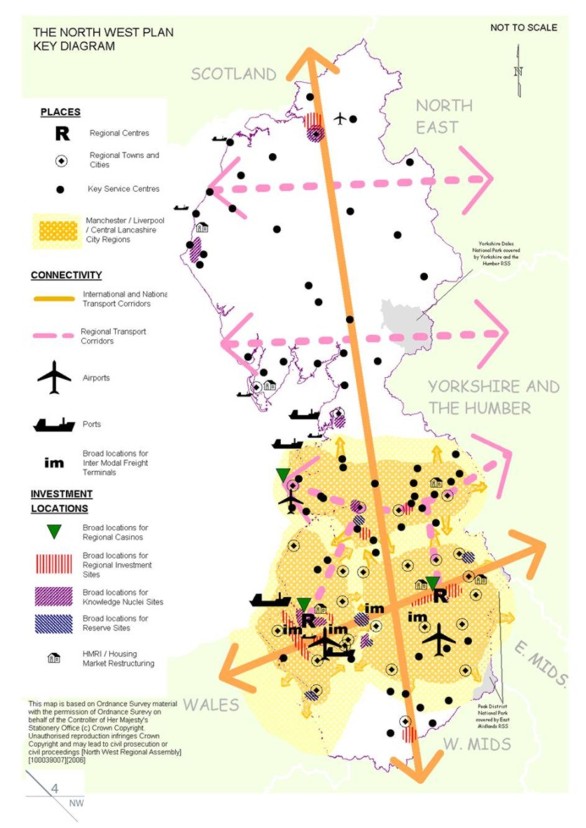
Furthermore, the move from a growth corridor to city-regions is important because it changed the spatial focus from a growth corridor across regions to city-regions within regions. Connected Cities, Fragmented RegionsOperating across parts of three of the UK's best performing regions South East, East of England, East Midlands John Allen and Allan Cochrane (2007) use the example of the Milton-Keynes South Midlands growth area in southern England to argue how the political and economic governance of city-regions is increasingly orchestrated through an assemblage of affiliations and networks which stretch across and beyond any given city or regional boundaries. Presented in this way, new and emerging spatial configurations, such as those in southern England, clearly evidence how globalization and state restructuring have rendered cities and regions more open and permeable to external influence. But so too does the Northern Way. Yet the degree to which one sees the Northern Way as evidence for relational thinking to replace territorial and scalar approaches is markedly different to that which Allen and Cochrane surmise from their study. First, the status of south east England as a polycentric global mega-city region makes the regional boundaries appear more open and porous given its proximity and long-established networks into the internationalising economy through the City of London, and its political ties to Westminster and Whitehall (Pain, 2008). As Jones and MacLeod (2004) are right to argue, while examples drawn from south east England provide a convincing case' of relational topologies, they are of a very specific' region where regional boundaries can be said to have less effect. Second, unlike Milton-Keynes South Midlands, the eight Northern Way city-regions are firmly nested within regions. In other words, under the auspices of the RDA-led steering group, the move from a growth corridor to city-regions represented a shift from a pan-regional spatial vision across regional boundaries to a spatial vision across and within regions. The result is the North West has three city-regions (Liverpool, Manchester, Central Lancashire), Yorkshire and the Humber three (Leeds, Sheffield, Hull and Humber Ports) and the North East two (Tyne and Wear, Tees Valley). The challenge faced by RDAs is how best to manage their responsibility for developing economic and spatial strategies and effective regional and subregional partnerships whilst at the same driving forward new networked governance arrangements that stretch across and beyond regional boundaries. Taking the example of North West England, this tension can clearly be seen in attempts to represent city-regions and cross-border flows in the key diagrams produced for the 2006 (draft) and 2008 (adopted) Regional Spatial Strategy (see Figures 1 & 2). Figure 1 Key diagram from the 2006 (draft) North West Regional Spatial Strategy
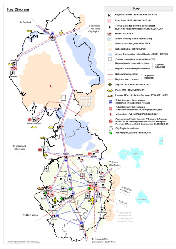
Figure 2 Key diagram from the 2008 (adopted) North West Regional Spatial Strategy
Evident across both diagrams are a series of key pointers that help uncover the processes by which city-regions are represented. In 2006, for example, the boundaries of the Manchester, Liverpool and Central Lancashire city-regions are defined loosely and schematically. Each city-region is shown to comprise a core area (contained by the regional boundary), and a small outer zone (which in some areas does extend beyond the regional boundary). However, the lines are ambiguous and do not correspond to any known administrative or functional boundary. In contrast, the city-region boundaries are clearly defined by hard, unambiguous lines in 2008. Not only this, they map directly onto the political and administrative boundaries as each city-region is formed by a coalition of local authorities and therefore bounded by local authority boundaries7. Second, the legacy of growth corridors is clearly evident in 2006 with north-south and east-west transport links to the fore, but less evident in 2008 when only the north-south corridor is easily identifiable. Third and somewhat what related to this, the transport links on the 2008 diagram represent the UK Government's hub and spokes definition of city-regions and emphasises city connectivity over the more outdated concept of urban growth corridors. And finally, the priority given to certain lines has changed. In 2006 transport corridors were prioritised despite their ambiguous and schematic representation while regional and city-regional boundaries are faded out. In 2008 transport and city-regional boundaries are identified by clear lines but these are secondary to the regional boundary which is now the most striking and clearly defined line on the diagram. All points which confirm that despite regional boundaries disappearing from the pan-regional spatial map of the Northern Way, and compelling evidence that spatial configurations are constituted through the spatiality of flow, city-regions are unable to escape the existing territorial mosaic of regional and subregional political-administrative units and boundaries. This is given further weight by the recognition that in the North West, like other regions, areas fall between or on the fringes of city-regions. Seen to be fulfilling their task of making the English regions more competitive, the commitment of RDAs to spreading economic prosperity and opportunity to everyone is putting them under increasing pressure as they become more spatially selective' in prioritising city-regions as areas for regional investment (Jones, 1997). Fragmented RegionsAffording Manchester and Liverpool city-region status was straightforward both are represented in the Core Cities group and located in the main east-west growth corridor. Where tension emerged was that Central Lancashire and Cumbria also claimed city-region status, despite both having: (i) a very contained and insular economy with limited engagement in the international economy; (ii) a weak urban core; (iii) a location outside either growth corridor; (iv) no representation in the Core Cities group; and (iv) no historical claim to being a city-region. In their favour, both areas were located in a third major growth corridor connecting (from north to south) Glasgow/Edinburgh, Manchester/Liverpool, Birmingham and London. From this it is perhaps surprising that one area, Central Lancashire, was afforded city-region status, while the other, Cumbria, was not. But this overlooks one key determining factor. For the decision to identify a Central Lancashire city-region came about because it contributes 20% of the North West's total economic output (measured as Gross Value Added) compared to Cumbria's 6%. Reaffirming the premise that city-regions are an essentially economic proposition, this decision re-opened debates over the spatial selectivity' of the state in privileging (and de-privileging) certain areas and spaces (Jones, 1997). Clearly the process of identifying Central Lancashire involved bending the concept of the city-region to artificially create a third city-region8. But despite the decision to afford city-region status on the economic logic, representation is according to a political and territorial logic. Unlike the Liverpool and Manchester city-regions which extend beyond the Merseyside and Greater Manchester subregions respectively, Central Lancashire does not extend beyond the subregional boundary of Lancashire. In fact, the city-region is clearly defined as comprising ten of the twelve local authorities that form the Lancashire subregion. In the first instance, the local authority of West Lancashire is incorporated into the Liverpool city-region owing to its proximity and economic ties into the city of Liverpool. More remarkable is that Lancaster, the northernmost local authority and closest to the subregional boundary with Cumbria, finds itself outside the boundary of the city-region given that it is home to one of Northern England's eight research-intensive universities which have come together to form a powerful alliance known as N8 to support the Northern Way. That one of these, Lancaster University, is located in the Lancashire subregion but not the Central Lancashire city-region is particularly interesting as it leaves Central Lancashire as one of only two city-regions not to have an N8 university within it9. So why is Lancaster the only local authority from the Cheshire, Greater Manchester, Lancashire and Liverpool subregions to fall outside the Northern Way? Prior to the reorganisation of local government in England and Wales in 1974, the political and administrative boundaries of the North West looked markedly different to those of today. At that time, what has become known as North West England was principally the historical county of Lancashire. Broken up in 1974, the historical county of Lancashire comprised what are now the counties of Cheshire, Lancashire, Greater Manchester and Merseyside, but also the southern part of Cumbria. While the boundaries of the five subregions map directly onto the boundaries of the five counties that comprise the North West, there remains a strong dividing line between south Cumbria and north Cumbria. Many in the south look further south to Lancaster as a key gateway to the economies of Liverpool and Manchester, while those in the north look further north to Edinburgh and Glasgow or east to Newcastle with whom they had political ties prior to 1974. The decision not to include Lancaster in the Central Lancashire city-region is therefore purely political. If city-regions are based on functional economic ties then the boundaries of the Central Lancashire city-region would be forced to expand much further north into Cumbria were Lancaster included, a move that would further fracture an already political divided county and subregion. All in all the challenge of representing, marking out and making city-regions visible is perhaps best summarised thus:
Conclusing CommentsOverlooked in the literature on city-regions, this paper set out to explore the processes by which city-regions are represented and marked out as new economic spaces and new spaces of politics in modern-day globalization. Two observations have been made. First, the case study of England offers a stark reminder that while representing the UK space economy as a relationally networked space of flows might provide a convincing argument for rejecting territorial and scalar approaches to conceptualising state space and state spatiality, this argument is most plausible theoretically and when looking across regions. But even then, as MacLeod and Jones (2007) have intimated previously, the evidence suggests that city-regions are unable to escape the existing territorial mosaic of regional and subregional political-administrative units and boundaries. Second, the case study of the Northern Way is particularly useful in demonstrating that while city-regions are designated and initially defined according to economic logic, the process by which they are made visible is the result of a compromised city-regionalism. In particular, the case study of North West England demonstrates how, following the designation of three city-regions, the challenge to define, delimit and mark out these city-regions was constrained, first, by the political and administrative boundaries of the region, and second, by historically embedded and politically charged claims to territory. In so doing it demonstrates how, far from escaping' regulatory supervision by the state (Scott, 2001a), the state retains a pivotal role (through RDAs) in centrally orchestrating the production of city-regions in England. The North of England also offers a stark reminder that rescaling is not simply the privileging of one scale of governance (city-regions) over another (regions), but a complex, multilayered, and fluid process. Politically it is possible to suggest that although the defined scales of policy making in England national, regional, local do not conform to spaces of flows, they are too institutionally, culturally and historically fixed to be reformed that is, unless the UK Government bites the political bullet and fundamentally reforms what is already there, something the Labour Government has so far proved unwilling to do. In this regard, the emergence of city-regions in England is, I suggest, a typical Labour endeavour with regards to governance it adds to existing arrangements rather than reforms them10. The result is new governance arrangements sit alongside elected government, which, as one planning official told me, is leading to more and more confusion:
We might also say, following Markusen (1999), that city region' remains a fuzzy concept, and perhaps politically it is intentionally so. Its hallmark in UK politics is that it is neither here nor there; it is not central state, nor is it directly associated with the ongoing debate about the merits of regions or localism. All of which contributes to growing confusion over the city-region in theory and practice. But as this paper has uncovered, as a confluence of powerful intellectual, social, economic and political forces, city-regions remain a crucible to provide fresh insights into how new spaces of governance are being produced in globalization, and more importantly, how they interact and intersect with other scales of governance: a view that would seem to lend support to Allmendinger and Haughton's (2009: 626) contention that in future work:
ACKNOWLEDGEMENTSThe arguments in this paper are informed by work on projects funded by the Economic and Social Research Council (PTA-030-2002-01629) and British Academy (SG-47714). Earlier versions of this paper were presented at the 2008 RGS Annual Conference and the 2009 AAG Annual Conference. I would like to thank the two reviewers of this paper for their insightful comments. REFERENCESAllen, J. and Cochrane, A. (2007). Beyond the territorial fix: regional assemblages, politics and power. Regional Studies 41, 1161-75. Allen, J., Massey, D. and Cochrane, A. (1998). Rethinking the region. London: Routledge. Allmendinger, P. and Haughton, G. (2009) Soft spaces, fuzzy boundaries, and metagovernance: the new spatial planning in the Thames Gateway. Environment and Planning A 41, 617-33. Amin, A. (2004). Regions unbound: towards a new politics of place. Geografiska Annaler 86B, 33-44. Amin, A., Massey, D. and Thrift, N. (2003). Decentering the nation: a radical approach to regional inequality. London: Catalyst. Amin, A. and Thrift, N. (1992). Neo-Marshallian nodes in global networks. International Journal of Urban and Regional Research 16, 571-87. Brenner, N. (2002). Decoding the newest metropolitan regionalism' in the USA: a critical overview. Cities 19, 3-21. Brenner, N. (2004). New state spaces urban governance and the rescaling of statehood. Oxford: Oxford University Press. Castells, M. (1996). The rise of the network society. Oxford: Blackwell. Department of the Environment Transport and the Regions (1997). Building partnerships for prosperity: sustainable growth, competitiveness and employment in the English regions. London: HMSO. Donald, B. (2001). Economic competitiveness and quality of life in city regions: compatible concepts. Canadian Journal of Urban Research 10, 259-74. Etherington, D. and Jones, M. (2008). City-regions: new geographies of uneven development and inequality. Regional Studies 43, 247-65. Goodchild, B. and Hickman, P. (2006). Towards a regional strategy for the north of England? An assessment of 'The Northern Way'. Regional Studies 40, 121-33. Harding, A. (2007). Taking city regions seriously? Response to debate on 'city-regions: new geographies of governance, democracy and social reproduction'. International Journal of Urban and Regional Research 31, 443-58. Harrison, J. (2007). From competitive regions to competitive city-regions: a new orthodoxy, but some old mistakes. Journal of Economic Geography 7, 311-32. Harrison, J. (2008). City-regions and governance. In Connecting cities: city-regions ed. C. Johnson, R. Hu, R. Abedin and M. Cramer, pp. 49-70. Sydney: Metropolis. Hazell, R. (2006). ed. The English question. Manchester: Manchester University Press. Herrschel, T. and Newman, P. (2002). Governance of Europe's city regions: planning, policy and politics. London: Routledge. HM Treasury, Office of the Deputy Prime Minister and Department of Trade and Industry (2004). Devolving decision making: 2 - Meeting the regional economic challenge: increasing regional and local flexibility. London: HMSO. HM Treasury, Office of the Deputy Prime Minister and Department of Trade and Industry (2006). Devolving decision making: 3 - Meeting the regional economic challenge: the importance of cities to regional growth. London: HMSO. Hogwood, B. (1996). Mapping the regions: boundaries, coordination and government. Bristol: Policy Press. Hudson, R. (2007). Regions and regional uneven development forever? Some reflective comments upon theory and practice. Regional Studies 41, 1149-60. International Journal of Urban and Regional Research (2007). Debates forum City-regions: new geographies of governance, democracy and social reproduction. International Journal of Urban and Regional Research 31, 169-223. Jarvis, H. (2007). Home truths about care-less competitiveness. International Journal of Urban and Regional Research 31, 207-14. Jessop, B., Brenner, N. and Jones, M. (2008). Theorizing sociospatial relations. Environment and Planning D 26, 389-401. Jones, M. and Jessop, B. (2010). Thinking state space compossibly. Antipode Jonas, A. and Ward, K. (2007a). Introduction to a debate on city-regions: new geographies of governance, democracy and social reproduction. International Journal of Urban and Regional Research 31, 169-78. Jonas, A. and Ward, K. (2007b). There's more than one way to be 'serious' about city-regions. International Journal of Urban and Regional Research 31, 647-56. Jones, M. (1997) Spatial selectivity of the state? The regulationist enigma and local struggles over economic governance. Environment and Planning A 29, 831-64. Jones, M. (2001). The rise of the regional state in economic governance: 'partnerships for prosperity' or new scales of state power? Environment and Planning A 33, 1185-1211. Jones, M. and MacLeod, G. (2004). Regional spaces, spaces of regionalism: territory, insurgent politics, and the English question. Transactions of the Institute of British Geographers 29, 433-52. Krueger, R. and Savage, L. (2007). City-regions and social reproduction: a 'place' for sustainable development? International Journal of Urban and Regional Research 31, 215-23. Leibovitz, J. (2003). Institutional barriers to associative city-region governance: the politics of institution-building and economic governance in Canada's technology triangle'. Urban Studies 40, 2613-42. MacLeavy, J. and Harrison, J. (2010). New state spatialities perspectives on state, space and scalar geographies. Antipode MacLeod, G. (2001). Beyond soft institutionalism: accumulation, regulation, and their geographical fixes. Environment and Planning A 33, 1145-67. MacLeod, G. and Jones, M. (2001). Renewing the geography of regions. Environment and Planning D 19, 669-95. MacLeod, G. and Jones, M. (2007). Territorial, scalar, networked, connected: In what sense a 'regional world'? Regional Studies 41, 1177-91. Markusen, A. (1999). Fuzzy concepts, scanty evidence, policy distance: the case for rigour and policy relevance in critical regional studies. Regional Studies 33, 869-84. Marston, S., Jones, J-P. and Woodward, K. (2005). Human geography without scale. Transactions of the Institute of British Geographers 30, 416-32. Massey, D. (2004). Geographies of responsibility. Geografiska Annaler 86B, 5-18. Massey, D. (2005). For space. London: Sage. Massey, D. (2007). World city. Cambridge: Polity. McCann, E. (2007). Inequality and politics in the creative city-region: questions of liveability and state strategy. International Journal of Urban and Regional Research 31, 188-96. McGuirk, P. (2007). The political construction of the city-region: notes from Sydney. International Journal of Urban and Regional Research 31, 179-87. Morgan, K. (2007). The polycentric state: new spaces of empowerment and engagement? Regional Studies 41, 1237-51. NWSG (2004). Moving forward: the Northern way. Newcastle: NWSG. NWSG (2005). Action plan. Newcastle: NWSG. OECD (2007). Competitive cities in the global economy. Paris: OECD. Office of the Deputy Prime Minister (2003). Sustainable communities: building for the future. London: HMSO. Office of the Deputy Prime Minister (2004). Making it happen the Northern way. London: HMSO. Office of the Deputy Prime Minister (2005). Planning glossary: a public guide to land use planning terms and phrases. London: HMSO. Pain, K. (2008) Examining 'core-periphery' relationships in a global city-region: the case of London and South East England. Regional Studies 42, 1161-72. Purcell, M. (2007). City-regions, neoliberal globalization and democracy: a research agenda. International Journal of Urban and Regional Research 31, 197-206. Rallings, C. and Thrasher, M. (2006). 'Just another expensive talking shop': public attitudes and the 2004 regional assembly referendum in the north east of England. Regional Studies 40, 927-36. Scott, A. (2001a). Global city-regions: trends, theory, policy. Oxford: Oxford University Press. Scott, A. (2001b). Globalization and the rise of city-regions. European Planning Studies 9, 813-26. Scott, A. and Storper, M. (2003). Regions, globalization, development. Regional Studies 37, 579-93. Segbers, K. (2007). ed. The making of global city regions. Baltimore: John Hopkins University Press. Simmonds, R. and Hack, G. (2000). eds. Global city regions: their emerging forms. London: Spon. Smith, N. (1992). Contours of a spatialized politics: homeless vehicles and the production of geographical scale. Social Text 33, 54-81. Swyngedouw (1997). Neither global nor local: glocalisation' and the politics of scale. In Spaces of Globalisation ed. K. Cox, pp. 137-166. New York: Guildford Press. Taylor, P. and Knox, P. (1995). World cities in a world-system. Cambridge: Cambridge University Press. Tewdwr-Jones, M. and McNeill, D. (2000). The politics of city-region planning and governance. European Urban and Regional Studies 7, 119-34. Thrift, N. (2002). Performing cultures in the new economy. In Cultural Economy eds. P. Du Gay and M. Pryke, pp. 201-34. London: Sage. Ward, K. and Jonas, A. (2004). Competitive city-regionalism as a politics of space: a critical reinterpretation of the new regionalism. Environment and Planning A 36, 2119-39. Zhao, S. and Zhang, L. (2007). Foreign direct investment and the formation of global city-regions in China. Regional Studies 41, 979-94. NOTES* John Harrison, Department of Geography, Loughborough University, UK, J.Harrison4@lboro.ac.uk 1. It should be noted that this is not an attempt to develop, as many have, a typical' (or worse, an ideal') model for city-regions. Rather it is to explore three key aspects of city-region development how they are spatially defined, delimited, and designated. 2. Opinion polls backed this up suggesting 72% of the electorate supported the creation of an ERA (BBC, 2002). 3. Available to view at http://www.communities.gov.uk/publications/citiesandregions/makingit [Last accessed 13 October 2009] 4. The Core Cities Group was established in 1995 to represent and increase the profile internationally of England 's leading regional cities: Birmingham, Bristol, Leeds, Liverpool, Manchester, Newcastle, Nottingham and Sheffield. Five of these cities Leeds, Liverpool, Manchester, Newcastle and Sheffield are located in the north of England. 5. Available to view at http://www.thenorthernway.co.uk/downloaddoc.asp?id=420 [Last accessed 13 October 2009] 6. This follows Neil Smith's (1992: 66) argument that once constructed, scales become active progenitors' in contain[ing] social activity, and at the same time provide an already partitioned geography within which social activity takes place, and subsequent work by Gordon MacLeod and Martin Jones (2001; 2007; Jones and MacLeod, 2004) which outlines how the 1940s regional planning boundaries in England came to be active progenitors' in shaping the post-1997 map of England's RDAs. 7. It is worth noting that some of the southern-most areas of the region which fell between city-regions in 2006 are now covered by the Liverpool and Manchester city-regions. 8.Interestingly the Tyne and Wear CRDP does not even mark out Central Lancashire as a city-region in its spatial vision (see City Region Development Programme @ http://www.tynewearcityregion.co.uk/) [Last accessed 13 October 2009]. 9. Of the other Northern Way city-regions only Hull and Humber Ports does not contain an N8 university. However, it does boast a research-intensive international university with over 20, 000 students. 10. I am particularly grateful to one of the referees for pointing to these connections, and pushing me to develop them here.
Note: This Research Bulletin has been published in Political Geography, 29 (1), (2010), 17-27 |
||