GaWC Research Bulletin 287 |
|
|
|
This Research Bulletin has been published in International Journal of Urban and Regional Research, EarlyView, under the title "‘New Worlds’ for ‘Old’? Twenty-First-Century Gateways and Corridors: Reflections on a European Spatial Perspective" doi:10.1111/j.1468-2427.2010.01005.x Please refer to the published version when quoting the paper.
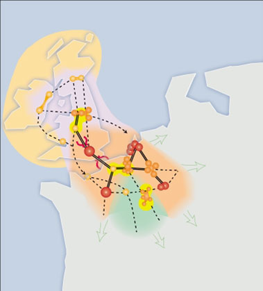
Introduction: Terminologies - old metaphors, new meaningsThe gateway and corridor concepts were originally developed to describe an apparent systematic ordering of urban places in the nineteenth-century pre-globalization era but there has been a surprising recent resurgence in their use to describe contemporary post-industrial forms of spatial organization. It seems that almost any major city anywhere can now be called a ‘global gateway’. A ‘transportation corridor’ can be a ‘gateway’ and an ‘urban corridor’ simultaneously, or the terms may refer simply to electronic information and communication infrastructures (for example, Van der Linden, 2005). This article considers the conditions leading to changing interpretations of these once taken-for-granted terminologies. It is intended as a ‘think-piece’ which contributes new insights into the relevance of the gateway and corridor metaphors in a contemporary European spatial planning context by reference to recent developments in global urban analysis1 and related research in the 2003-06 North West Europe Polynet study2. Massey (1999) has argued that contemporary cities should be understood as conduits of globalization and Short et al. (2000) deliberately use the term ‘gateway’, instead of ‘global city’, to highlight the ways in which cities can be affected by globalization. Similarly, Andersson and Andersson (2000; 2005: 92) and Rossi and Taylor (2006) refer to the gateway concept to illustrate the different roles and functions of cities in relational networks associated with globalization. New metaphorical associations, meanings and relevancies attached to gateways as produced by and productive of contemporary global change, reflect the recent major paradigm shift in spatial theorization. Whereas positivist approaches to space have focused on cities and their interconnecting trading routes as physical and material land useconfigurations, recent theorization reflects a more nuanced understanding of urban space as a relational process. A distinction between traditionalist and new spatial theoretical perspectives has important implications for the incorporation of gateway and corridor terminologies in contemporary policy. This article examines how the roles and functions of cities and their corridors are changing in a globalizing world that is a key focus of European policy attention3, the implications for the conceptualization of urban development and the question in what ways the gateway and corridor metaphors can inform policy formulation in an increasingly global era. It is structured in three main sections. Firstly, evolving understanding of the changing dynamics of urban organization since the gateway and corridor concepts were first posited is examined with specific reference to the application of network theory in global urban analysis which informed the Polynet study. Secondly, the interpretation and application of the gateway and corridor concepts in ‘Old World’ spatial development (ESDP) strategy which frames European regional policy, is critically assessed in the light of these theoretical and analytical developments. Thirdly, drawing on the empirically informed findings from the Polynet research which investigated the dynamics of global change now framing European urban roles and functions, a series of paradoxes relevant to the conceptualization of contemporary urban development is identified. Finally, key implications for the management of globalizing gateways and corridors are considered. Gateways and corridors in spatial analysisReference to gateways and corridors in spatial analysis and planning practice has emphasized their active role as determinants of regional economic development patterns. The origin of the gateway concept in North American ‘frontier’ urban location and systems theory is well documented (Ullman, 1957). Burghardt (1971) has explained how gateway cities have traditionally been seen in the literature as quite distinct from Christallerian ‘central places’, or ‘hubs’ (as depicted by von Thünen in 1875), due to their unique positional and morphological characteristics, “an entrance into (and necessarily an exit out of some area)” … “The entrance tends to be narrow and will probably be used by anyone wishing to enter or leave the tributary area “behind” [thus] the city is in charge of the connections between the tributary area and the outside world” (1971: 269). The economic status of older cities commonly remains associated with their historical siting at so-called ‘natural’ gateways, harbours, fording points of rivers and so on and the ability this has afforded them control over movement into and out of their regional hinterland markets. Burghardt included a small selection of older central European cities (now in Slovakia) in his 1970 analysis and found parallels with the gateway development pattern identified in North America. In Burghardt’s view, both in North America and in Central Europe, gateway cities are defined by positions which “possess the potentiality of controlling the flows of goods and people” (1971: 282). Similarly, the movement of people and commodities along ‘natural trade routes’, or the ‘corridors’ between gateways, has been seen to give pairs or chains of cities a unique locational advantage with respect to transport and wholesale functions and the power to regulate physical trade flows between them. Whebell (1969: 1) defines the term corridor as a historically persistent “linear system of urban places together with the linking surface transport media”. In other words, the corridor is not just a transportation infrastructure, it is part of an urban infrastructure which has relevance for regional economic policy. From these explanatory roots, the gateway and corridor concepts have continued to inform North American transportation policy and planning (Gillen et al. 2007). With the transcontinental stretching of trading relations through a multiplicity of global supply chains, the specific routes taken by freight and passenger traffic flows appear ever more crucial. At the same time, the local intensification of flows, and the proliferation of transport infrastructures and terminals in complex multi-modal corridors and gateways, requires long-term planning, major investment and cross-border co-ordination of inter-modal systems and transfers. Reflecting Whebell’s (1969) thinking, the notion of the complementary power of gateway and corridor infrastructures to shape regional economic development has been reflected in the ‘Old World’ context of current European spatial strategy also, and it is this specific setting which is the primary focus of consideration in this article. From Gateway Hinterlands to HinterworldsPredating the gateway and corridor literatures, Christaller’s ‘Central Place Theory’ of 1933, based on development patterns in Germany, illustrates three features of early urban theorization which have continued to inform ‘Old’ as well as ‘New World’ spatial policy to the present day - a focus on local and hierarchical urban-hinterland relationsand regional boundaries. A scale of analysis based on relatively local urban and regional systems, patterns of industrial specialization and hierarchies of service functions, remains a key basis for development policy in Europe. Burghardt’s gateway thesis was built upon the assumption that different sizes, roles and functions of urban centres constitute hierarchical relations. ‘Hubs’ at the top of the hierarchy have a relatively central position within a geographic region and a radial hinterland with a hub-and-spoke distribution of transportation corridors. Gateways have a distinct spatial form and function which reflects their location on a regional boundary and their ‘gatekeeper’ role in controlling accessibility, also identified by Burghardt in Central Europe (1971: 282). But while the body of theory which gave rise to the gateway and corridor concepts prioritized morphology (locational specificity, site and situation) as the key determinant of trade routes, and thus differential development between a “fertile” gateway hinterland and an “infertile” adjoining region (Burghardt, 1971), recent spatial theorization reflects the increased complexity of modern development processes. As emphasized by Whebell (1969), transportation and the organization of space have reciprocal relations and these now involve fungible as well as tangible cross-border trade flows, making urban ‘hinterlands’ an increasingly global interactional space4. The reciprocity between gateways and corridors through the mobility of material goods thus now reaches far beyond proximate hinterlands and regions, extending to what Taylor (2001b) has conceptualized as ‘hinterworlds’ which describe a globalizing city’s world-wide connections5. Thus, whereas location and systems theories were based on the analysis of clearly demarcated sub-national geographical entities, the mutual constitutionof local and global spheres of economic interaction associated with processes of ‘globalization’6 indicates the need to re-think the paradigm of infrastructural development (Graham and Marvin, 1996; 2001) and scales of urban analysis (Herod and Wright, 2002; Marston, Jones, and Woodward, 2005)7. Indeed Burghardt did not see the gateway model as a static explanatory tool. His thesis was intended as a description of historical evolutionary development patterns, not an end point. While the changes associated with globalization have been interpreted as a continuation of historic international trading relations by some theorists, an appreciation of the significance of developments in electronic information and communication technology (ICT) modes for cities and regions is clearly of crucial importance. Not only have these developments led to an intensification of virtual cross-border flows and an ‘informational economy’ but other economic sectors are increasingly dependent on specialized knowledge-based advanced services to add value to production and trade. Thus primary and secondary, as well as tertiary markets and their production networks, increasingly involve cities (Pain, 2008a). The implications of these changes for spatial theorization, considered next, are significant. Theorizing a ‘New’ World Urban Spatial OrganizationOf the extensive interdisciplinary literature which has accompanied recent global transformation, Sassen’s (1991) ‘global city’ and Castells’ (1996) ‘network society’ hypotheses stand out as highly influential in new spatial theorization. Since the emergence of the globalization discourse, ‘end of geography’ and ‘death of distance’ predictions (Ohmae, 1990; Cairncross, 1995, 1997a; 1997b) have anticipated that the role of cities as locations for business would become less important with the virtualization of economic activity. But, building on Friedmann’s (1986) notion of a ‘world city hierarchy’in which London, New York and Tokyo are ‘global financial articulations’ followed by ‘multi-national’ and ‘important national articulations’, Sassen (1991; 1994) identified the importance of ‘advanced producer services’ (APS) – or business service providers to other businesses such as financial services - in giving certain cities a global economic role and status, and strategic ‘command and control’ functions. Although APS production has dispersed to service multi-national companies (MNCs) world-wide,it has continued to concentrate in key world trading centres or ‘global cities’. Hence in 1992, Drennan made an important connection between the global ‘exports’ of such producer services and the changing role of traditional US gateway cities. Similarly Pred’s subsequent observations on the rise of the ‘new’ economy (1997, cited by Taylor and Aranya, 2006) suggest the emergence of a change in the role of traditional gateway cities. Linking the major developments in electronic technologies at the end of the twentieth-century to the concept of a network society, Castells (1996) saw the parallel rise of the ‘network organization’ and ‘informationalization’ of the world economy as fundamentally changing the spatial relations of cities. Castells’ famed metaphorical distinction between two forms of space – a ‘space of flows’ and of ‘places’ - challenged traditional spatial and urban analysis (2000: 163-215). His prediction of the dominance of the space of flows over the material geography of places suggests the need for two critical analytical changes - first to focus analysis on the relations between cities which cross (territorial urban and regional) boundaries, and second, to appreciate cities as nodes for informational flowsand exchanges associated with new modes of production inglobal APS networks. Information of all kinds is now transported globally through electronic networks and, with deepening global ‘connexity’ labour and transport costs apparently have less relevance as business location determinants (Pain, 2008a). Finance, skills and functions are increasingly motile through cities, yet informational flows associated with commercial APS network structures havereinforced the importance of certain cities as global trading hubs as well asinformational gateways. Thus the increasing importance of the border-hopping external relations of cities in globalization (Allen, 1999: 109-202; Taylor, 2001a; 2001 b) implies a rolefor regionalhubs as new informational nodes and thus gateways. Service economy flows may have different routes and geographies to those of material transportation corridors, leapfrogging coasts, mountain ranges, etc. As Castells has indicated, they also pose a challenge for governance structures which are similarly ‘fixed’ within a territorially defined and politically boundedspace ofplaces. Their immateriality and fluidity makes the space of flows difficult to map, posing a dilemma for policy. For this reason, Taylor’s customized methods of mapping hinterworld geographies based on network theory in ‘World City Network’ (WCN) analysis, fills an important void in the evidence base on the inferences of this spatial metamorphosis for different cities (Taylor, 1997; Taylor and Pain, 2007). Analytical outputs from successive WCN studies provide key intelligence to inform policy on the emergent geographies of APS firms which cluster in, and inter-link, new gateway cities through their ‘network corridors’. Researching World ‘City-Network’ RelationsWhile a number of studies have attempted to capture information about elusive inter-city flows associated with air traffic and telecommunications, these do not inform understanding of the service network relations that now define the development of city economies, nor the processes which give rise to flows of information, skills, knowledge transfer between cities. For example, Alderson and Beckfield’s (2004) large-scale study of multi-national enterprises (MNEs) focuses on the power that headquarter (HQ) functions confer on ‘world cities’ but does not pick up the complex flows associated with knowledge-intensive business service networks (Taylor, 2006). Unlike this and other conventional urban studies using comparative attribute data derived from secondary official (place-specific) statistics to compare the performance of cities, WCN analysis focuses on the space of inter-city flows by studying the geographies of network organizations operating across many cities. By focusing on dominant knowledge-intensive APS industrial functions governing worldwide knowledge production and trade flows as subjects of study, WCN studies shed light on the world-wide organizational geographies of the key agents (firms) such as banking and finance, law, management consultancy, insurance, advertising and so on, which construct complex invisible inter-linkages between cities through synonymous processes of world-wide dispersal and concentration identified by Sassen (1991; 1994). Analysis of large-scale data bases on firms’ servicing strategies across their networks of global city-based offices in the three dominant world economic regions - North America, Western Europe and Pacific Asia (Friedmann, 1986) - allows the trans-regional, trans-national, and trans-continental linkages between cities to be measured (Beaverstock et al., 2000; Taylor, 1997; 2001a). The presence of multiple global service networks in any one city increases its nodal connectivity and thus its inter-linkages to other cities world-wide, described as ‘global network connectivity' (GNC).8 Plotting the number of offices, their size, functions and importance within these global service networks reveals the highs and lows in the world-wide connectivity and inter-linkages of any one city to others and to sources of informational flows and knowledge worldwide. In-depth face-to-face interview studies with senior global APS agents provide insights into the relationships and interactions between cities that are generated by commercial organizational network structures.9 Whereas Christaller’s hinterland based on early twentieth-century regional development patterns, related to a scale of economic relationships prevailing in Europe in a pre-globalization era, analysis has focused on the city hinterworlds associated with Europe’s economic ‘zones of influence’ which now extend and overlap world-wide through invisible knowledge-based trading. With progressive global economic integration, formal territorial systems of governance have appeared to lose authority, to be replaced by more diffuse power relations and in this context, unsurprisingly, cities, regions, states and trading blocs are considered economically threatened by cross-border flows of business and labour. But WCN research suggests that this is an over-simplistic response; spatial relations are more complicated than (a hierarchy producing) zero-sum movement of flows between cities and regions. Service economy relations inter-link citieson the basis of network complementarities within and between firms, industrial and economic sectors in which cities and regions have a range of roles and functions (Taylor and Pain, 2007). But to what extent are these synergistic hinterworldspatialities reflected in the conceptualization of gateways and corridors in urban and regional policy? This question is considered next in the context of the European spatial planning framework which sets the policy context for the regions studied in Polynet.10 Application of the gateway and corridor concepts in European spatial strategyAlthough the gateway and corridor concepts have been most strongly associated with New World urban systems, they have had a significant influence on current European Union (EU) policy which has actively promoted their use in strategic planning. The key spatial strategy document the European Spatial Development Strategy (ESDP), (European Commission, 1999) provides the framework for European Member State urban and regional policy which has been considered an international role model for progressive regional planning, including in North America (Ross, 2008). Its central aims are intended to support key priorities of the ‘Lisbon’ and ‘Gothenburg’ Agendas (European Council, 2000; European Commission, 2001; European Union, 2008) to enhance Europe’s economic competitivenessin the global knowledge economy, and to promote social cohesion and sustainable development across an enlarged Europe. These objectives are to be achieved through the pursuit of a balanced distribution of urban development, or ‘polycentricity’, at metropolitan and regional scales across the EU territory (Hall and Pain, 2006). While the ESDP is a non-statutory document, it has been highly instrumental in moulding Member State policy. It actively discourages the concentration of development in major European cities and in the densely urbanized European Central Zone or ‘Pentagon’ area, defined by the cities of London, Paris, Milan, Munich and Hamburg, and supports the growth of smaller towns and cities through major Structural Funds investment. Gateways and corridors constitute key delivery vehicles to achieve this strategic intra- and inter-regional spatial rebalancing. The Components of Hinterland StrategyEuropean Regional Development Funds (ERDF) support cross-border policy cooperation to promote polycentricity through a wide range of research (ESPON), framework’, ‘action’ and ‘investment projects’ (INTERREG). These place strong emphasis on transportation and urban infrastructure strategic control and investments in regional policy. Established infrastructures are seen as a cause of differential territorial development which can be manipulated through state intervention. The gateway and corridor concepts feature strongly as spatial policy toolsbut they lack theoretical definition and are less directly considered in terms of contemporary economic trading relations than were their earlier North American counterparts (Whebell, 1969; Burghardt, 1971), reflecting a planning approach which predates recent relational and network approaches in spatial theorization and research.Burghardt (1971: 284) foresaw that technological developments that would transform the gateway concept as ‘terrain constraints’ became eroded by technological developments, reducing the importance of physical barriers and prioritizing the ‘spacio-economic connections’ of cities. In the ESDP, “gateway cities” are described as “large seaports, international airports, trade fair and exhibition cities and cultural centres” which provide access to the EU territory and also to peripheral “metropolitan regions”, with advantages such as low labour costs or links with economic centres outside the EU, which are to be expanded (European Commission, 1999: 22-23). Elsewhere, “global gateways” are described as transportation hubs, specifically seaports and airports, which are to be well distributed and links with their hinterlands increased to provide more balanced access to intercontinental transport and service levels (1999:27). “Corridors” are generally referred to in terms of transport infrastructures. “Congested corridors” are seen as reducing functional effectiveness within the EU core area. “Eurocorridors” with multimodal infrastructure (1999:36), transnational cross border “development corridors” or “infrastructure networks” (1999:70), and “Trans-European Networks” (TENs) (1999:26), made possible by recent European integration, are to be promoted. Spatial policy thus utilizes the corridor concept, which described “natural” trade routes in North America, as a means of achieving improved cross-border accessibility and territorial cohesion across EU state boundaries. The companion document to the Spatial Strategy, the North West Metropolitan Area Spatial Vision (NWMA, 2000) sets the operational spatial planning objectives and plan for the European economic ‘Central Zone’. Here London and Paris are referred to as “global cities/gateways” in a hierarchy of European cities. Their global competitiveness is to be maintained but their physical growth constrained, while their internal and external accessibility are to be increased. At the same time, development is to be promoted in other locations (via corridors) where “counterweight global gateways” outside the European ‘core’ have the potential to develop global command functions (see Figure 1). Transportation infrastructures are prioritized as key delivery vehicles, with “transport axes” serving as “development corridors” (Nadin, 2002: 34). Flows from London, Paris and the Pentagon to other regions of Europe are to be promoted through TENs (Trans- European Networks). In the UK, the Midlands and North of England are identified as counterweight global gateways (2000: 30-33) and the Channel Tunnel Rail Link/M2-M20 and West Coast ‘Main Line’/M1-M6 as important “Eurocorridors”. The “corridors/transport axes” connecting Hull and Immingham with Rotterdam and Southampton with Le Havre are to be strengthened (2000:30-1) and London ‘Thames Gateway’ is identified as an important “bottleneck”. Completion of the high speed train (HST) network is a priority to provide connections to other parts of Europe (2000:29). Figure 1 The North West Europe spatial vision (source: NWMA Spatial Vision Group, 2000)
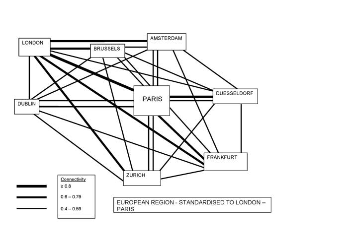
These strategic priorities and concepts have been rigorously adopted in the UK Government ‘Sustainable Communities Strategy’ (ODPM, 2003a; 2003b; 2004) and rolled out in regional and local government policy. For example in ‘The London Plan’ (Mayor of London, 2004), London is described as a ‘world gateway city’. The London airports - Gatwick, Stansted and Heathrow - and the Channel Tunnel are described as ‘external gateways’. Even the London-Stansted-Cambridge corridor and the Greater South East ‘mega-region’ are described as ‘gateways’ (Mayor of London, 2004:15), (see also EEDA, 2006). But the distinctions between urban areas, corridors and gateways are blurred in the two documents. Unlike Burghardt’s gateway definition, which makes a clear distinction between ‘hub’ and ‘gateway’ cities, in EU spatial policy ‘nodal’ cities such as London and Paris also have a ‘global gateway’ role. There is a similar lack of clear distinction between corridors and urban areas, yet there is an implicit understanding that urban gateways will not only be linked by new bundles of infrastructures but also an integral part of proposed major Eurocorridors. These conceptual ambiguities should be of concern to places outside Europe which are actively drawing on, supposedly advanced, EU spatial planning experience. Conceptual AmbiguitiesUnderpinning a lack of conceptual clarity, there is an underlying assumption that the development of new Eurocorridors will stimulate peripheral growth while at the same time enhancing Europe’s external economic competitiveness however the specific linking mechanisms between major investment in physical infrastructures and the rebalancing of metropolitan and regional economic development are not discussed or demonstrated. Significantly, there is a basic contradiction underpinning theorization of the roles of global gateways and corridors in economic and spatial policy. European global gateway cities and their external, international corridors, are represented positively by the Lisbon Strategy as attracting flows into the EU knowledge economy, while their specialist global function within Europe is interpreted negatively in spatial strategy (the ESDP) as reinforcing unequal, internal territorial relationships. This representation results in the opposite framing of the gateway and corridor roles with respect to the spatial dynamics of development as contributing both to more balanced economic but more uneven territorial development. This contradiction would seem to reflect bi-polar positive and negative interpretations of the outcomes of globalization identified by Cochrane and Pain (2000). While it is nowhere explicitly stated, and competition between cities and regions is firmly discouraged, the logic behind the ESDP/NWMA use of the gateway and corridor concepts implies a redistributive development scenario designed to combat perceived hierarchical spatial relations. The overall schema has been highly influenced by the French EU presidency derived European ‘Social Model’ and the concept of ‘territorial cohesion’ which has a political-institutional as well as a social agenda (Faludi, 2004; 2005). While spatial policy intentions to unify fractured approaches to development across the expanding jigsaw of member state political boundaries (illustrated by TENs/HST initiatives to address the challenges posed by institutional fragmentation of Europe’s railway systems) can be seen as laudable, there is growing practitioner scepticism about the application of spatial concepts, polycentricity, gateways and corridors, in implementation. The concept of polycentricity has been criticised as normative (Taylor et al., 2003: 73; Davoudi, 2003: 991-995) and the value of applying the gateway and corridor concepts as policy tools is inadequately supported by substantive evidence. Murtagh (2005: 1) for example notes that “much of the rhetoric of the ESDP loses its meaning the further down the spatial scale we go”. Citing the 2003 National Spatial Strategy (NSS) for the Republic of Ireland, which bears “the ESDP imprint”, as an example, Murtagh (2005: 2-3) refers to the application of the concept of a “linked gateway along a notional economic corridor” as holding an “important appeal for local politicians and business interests but it is not clear what is the nature, source and content of the ‘dynamic’ referred to in the NSS (2003). Moreover, it is not obvious how these connections would be made in regional or local planning, through economic development strategies or in structural arrangements to develop cross-border administrative, civic or political cooperation”. Similarly Nadin’s extensive research on the application of the NWMA Spatial Vision in North West Europe, reports that the notion of the “counterweight global gateway” in particular is regarded by practitioners with “much scepticism” and can be seen as “perhaps a political slogan” (2002:34). The EU ‘Corridesign’ project has identified a plethora of different opinions on the practical implementation of euro- or ‘mega-‘ corridor strategy in North West Europe due to the existence of “a multitude of social interests” (Priemus and Zonneveld, 2003: 176). In summary, the conceptualization of space in current European policy is based on traditional land use planning approaches which seek to manipulate territorial relations primarily using physical solutions. Priemus and Zonneveld emphasize that corridors “should not be conceived as an entity occupying physical space” (2003: 176). The gateway and corridor terms are of course abstractions but their use as policy tools reflects positivist thinking. They are seen as mechanisms of change capable ofrealigning existing development in accordance with political priorities, but is the rationale behind current strategic objectives and major investment based on a spatial perspective which is now redundant? The Lisbon Agenda seeks to improve EU performance in the wider global knowledge economy but spatial policy is EU-centric, adopting an approach which focuses on the territorial space of places. But this intellectually ‘grounded’ spatial framework fails to take into account, and leverage,functional specialization and associated complementarities between cities which are conferred by new (technology-facilitated) global network practices. A 2005 review of the Spatial Vision simply reiterates the existing (2000) focus on European hinterland relations (Duhr and Nadin, 2005: 49). The findings from the ‘Polynet’ research are reviewed next in order to assess the implications of this hinterland approach for globalizing European urban regions. New regional geographies of network organizationSupported by the European Regional Development Fund (ERDF), the 2003-06 Polynet study has uniquely investigated APS network development in Europe using GaWC WCN methodologies which have special relevance for ‘Lisbon Agenda’ economic priorities (European Council, 2000). The geographical space considered consisted of eight highly urbanized regions in the EU economic Central Zone, each comprising many towns and cities - ‘South East England’, ‘Paris Region’, ‘Central Belgium’, ‘the Randstad’, ‘Rhine Main’, ‘RhineRuhr’, ‘Greater Dublin’ and ‘Northern Switzerland’. Customized, complementary quantitative and qualitative data were gathered to investigate their connectivity to APS networks operating at regional, national, EU and global scales, informing European policy on the issue of regional polycentricity. The empirical results are documented in a series of research reports, book, and journal publications.11 The specific new focus here is the implications of the evidence for spatial policy and practice in the context of gateway and corridor development. Network Spaces – New Gateway Roles and FunctionsEU integration in cross-border APS networks is producing complex, multi-scale urban inter-linkages in North West Europe.The organizational structures of multiple networks are interlinking the regions in the Polynet study to each other and to other cities world-wide. Between the years 2000 and 2004, London retained its pre-eminent global city connectivity in Europe and in the world but, importantly, quantitative and qualitative interview data show that the global service centre function, produced by apparently contradictory processes of dispersion and centralization as postulated by Sassen (1991; 1994), is not to exclusive to London. APS global network functions are concentrating in all eight regions in the study. Within Europe, after London which ranked first with the highest global network connectivity (GNC) score (1.00), the cities of Paris ranked second (0.70), Amsterdam equal fourth (0.59), Frankfurt fifth (0.57), Brussels sixth (0.56), Zürich seventh (0.48), Dublin equal ninth (0.43) and Düsseldorf equal twelfth (0.39), had the highest GNC scores in their regions and were also strongly inter-linked to each other by their common global APS networks as depicted in Figure 2. In-depth interviews with senior business managers in all regions (Pain, 2005), reveal that this concentration of global functions is essential to support transnational business, giving these cities a specialized ‘global gateway’ role which articulates regional and national markets into the world service economy. Figure 2 European Service Network Linkages (source: Taylor and Evans 2005)
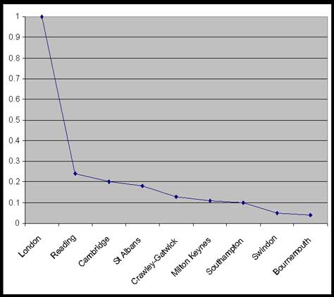
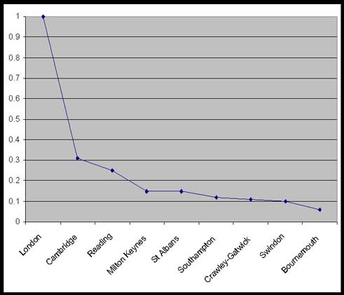
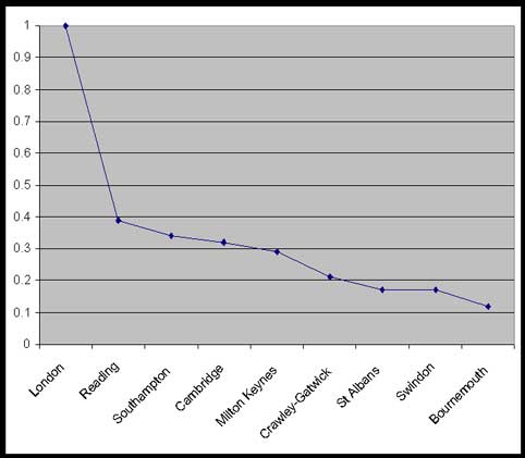
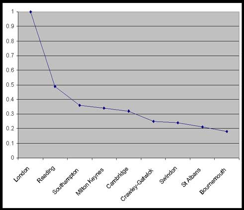
Note: Inter-city connectivities are calculated as a proportion of the highest connectivity, London-Paris Subsequent GaWC WCN studies which have extended quantitative analysis to an interregional scale in the UK, reveal the increasing connectivity to global networks of medium sized cities outside South East England also (Taylor and Aranya, 2006; Taylor et al., 2009). Beyond Europe, a similar pattern of inter-urban functional complementarity has been identified in Brazil, Southern America (Rossi and Taylor, 2006). Here Sao Paulo is the dominant gateway for banking services but banking networks are also using other Brazilian cities to service regional and national markets, resulting in a complex inter-city, service geography in a ‘developing’ economy too. A process of APS concentration with dispersion is therefore integrating more cities in the WCN than Sassen’s premier ‘global cities’, and in Europe this is creating a denser urban space that is characterized by hinterworld relations.12 Moreover, there is also evidence of emergent inter-city linkages within each urban region due to APS network presence. Global functions are concentrated in the eight gateway cities but interview data reveal that proximate centres have complementary regional network functions. In South East England (the largest MCR studied), high connectivity conferred on London through APS network agglomeration is giving rise to network inter-linkages between much smaller urban centres beyond it across an area of 29,184 square kilometres. This scale of functional inter-linkage, referred to in the study as a global ‘Mega-City Region’(MCR), is not recognized in present ESDP-led policy on polycentrism. This is an important omission because the sub-global urban geographies of business network organization can produce ‘functional polycenticity‘ which overlays statutory regional boundaries and diverse morphologies, including monocentric morphologies such as that of South East England. Figures 3-6 show the inter-urban linkages (functional polycentricity) constructed by global to regional scale APS networks which have offices in London and in eight proximate, smaller urban centres. Figure 3 South East England global scale connectivity (source: Taylor and Evans, 2004)
Note: Connectivities are calculated as a proportion of the highest connectivity, London Figure 4 South East England European scale connectivity (source: Taylor and Evans, 2004)
Note: Connectivities are calculated as a proportion of the highest connectivity, London Figure 5 South East England national scale connectivity (source: Taylor and Evans, 2004)
Note: Connectivities are calculated as a proportion of the highest connectivity, London Figure 6 South East England regional scale connectivity (source: Taylor and Evans, 2004)
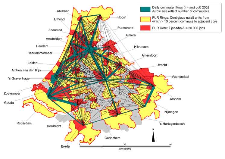
Note: Connectivities are calculated as a proportion of the highest connectivity, London The evidence suggests a first paradox (1) that should inform European spatial policy on the relationship between gateways, corridors and polycentricity – The reciprocity between APS concentration in ‘global gateway’ cities and the emergence of functional polycentricity produced by business network extension at a sub-global scale. Current spatial policy aiming to achieve regional economic rebalancing by discouraging APS global gateway concentration is therefore not only likely to be ineffective but counterproductive. Spaces of Flows – New Materialities and CorridorsViewing the new European global gateway role from a network perspective suggests an analogy with that used by Burghardt in predicting the changes that would transform traditional gateway cities with developments in ICT. He likened their future role to that of “the power boxes or valves which connect a house with the greater urban utility network” (1971: 282),13 yet the Polynet findings suggest a further paradox relating to inter-city connectivities that challenges existing European spatial policy. In spite of ESDP priorities to minimize intra-regional travel in order to promote environmentally sustainable development, and increasing use of virtual communications, polycentric urban development was found to generate intense cross-cutting mobility through commuting and business travel in all MCRs. Face-to-face contact remains essential even for business in global APS networks which exploit virtual communications intensively, because relationships, trust, and team building are critical. But, regardless of differences in the degree of active APS functional polycentricity in the eight urban regions, in all cases a polycentric development pattern was seen to be generating intra-regional movement which cannot be supported effectively by strategic corridors or public transport (Pain, 2005). The Randstad case illustrates the underlying incompatibility between ESDP objectives to reduce travel by car and the polycentric urban region model (Kloosterman and Lambregts, 2001; Werff et al., 2005; Lambregts, 2008). High levels of cross-commuting associated with the region’s balanced urban morphology were mapped in the Polynet study (as illustrated in Figure 7) yet interviews show that active APS inter-city business interaction is less prominent than in morphologically monocentric South East England. The spreading out of urban economic centres at a regional scale thus generates major challenges for the management and financing of efficient and environmentally sustainable physical transportation modes and infrastructures,14 but the economic drivers underlying intensive daily physical interaction and mobility at this regional scale are not presently confronted by ESDP policy. Figure 7 Cross-commuting in the polycentric Randstad, Netherlands (source: Werff et al., 2005)
A major contradiction can therefore be identified between the ESDP focus on polycentric urban regions as promoting environmentally sustainable development and the reality observed in all eight MCRs – a spider’s web of heavily car-dependent travel. Investment in strategic transportation corridors does not address the problems posed by this fine scale of mobility involving multiple proximate urban centres. Furthermore, interviews with planning and business practitioners show that there are serious doubts about whether investment in major new strategic transportation corridors15 will be successful in diverting market-led development.16 This suggests a second paradox (2) not presently confronted in European spatial policy – The reciprocity between regional polycentricity and the emergence of complex material flow spaces. Current policy encouraging polycentric regional development is so far proving ineffective and counterproductive in promoting a more sustainable development pattern. New MCR Flow Spaces but Hinterland GovernanceTwo interconnected urban ‘infrastructures’ can therefore be identified as important features of new European geographies of regional development: A - business network infrastructures (commercial APS organization), and, B – material flow infrastructures (urban fabric and transportation). Evidence from the final phase of the study, which investigated policy approaches in the eight MCRs, shows that a third key infrastructure which should interact with, and have an important bearing on, these also proves problematic: C – public sector governance infrastructures (regulatory and legislatory frameworks). A coordinated and flexible response to the dynamic geographies relating to new gateway and corridor reciprocities (A and B) is needed but, in all MCRs, existing institutional and governance structures are seen as inadequate to deal with the complexities of emergent development processes. The key common challenge identified relates to relatively fixed horizontal and vertical decision-making and jurisdictional structures. As indicated by Castells (1996) hypothesis of a “structural schizophrenia” between “two spatial logics” - of flows and places (second edition 2000: 459), the multi-scale network flows and functional linkages identified in the study prove to have a different spatial logic to the fractured European space of territorial and administrative boundaries. Firstly, emergent new spaces of inter-city functional relations do not correspond to existing regional administrative boundaries which cross-cut the de-territorialized space of global business networks. Secondly, policy analysis shows that MCR development is not responded to in a coordinated way due to inter-authority divisions and competition. These disjunctions allow basic contradictions underpinning the concept of regional polycentricity to go unresolved and it may even be that it is the fragmented nature of governance structures that has led to a competitive territorial framing of urban relations in the ESDP polycentricity concept in the first place. The lack of effective spacio-functional oversight noted at the MCR scale therefore leads to a third paradox (3) – The divergence between hinterland governance and emergent city hinterworld spaces. Cities are increasingly inter-linked by multi-scale flow spaces but are managed in a territorially framed hinterland space. Conclusion – the management of globalizing urban spacesThis review of evidence from the Polynet study has drawn attention to a series of paradoxes which challenge key premises underpinning the concept of regional polycentricity and the application of the gateway and corridor metaphors in spatial policy. They shed light on the complexity of scalar issues relating to globalizing European urban spaces:
Ongoing research is needed to unravel the full implications of the Polynet results for spatial policy18 but some preliminary conclusions can be identified. While the ESDP is already encouraging horizontal cross-border cooperation between government actors within Europe, which has a bearing on paradox 3, paradoxes 1 and 2 reveal that the premises of its key policy implementation device, urban polycentricity, greatly over-simplify the relational dynamics currently being witnessed in urban regions in North West Europe. The Polynet findings indicate that a more nuanced conceptualization of emergent new European urban spaces, and the roles of gateways and corridors as part of this process, is needed to manage increasingly complex and fluid functional relations between its cities. Effective engagement with this new kind of ‘old world’ space suggests the need for two specific shifts in present policy orientation. First, an appreciation of the de-construction of territorial relations associated with WCN reciprocities (paradox 1). This makes the scale-dependence of the strategic ESDP policy tool, spatial polycentricity, outmoded and global (gateway) agglomeration a necessity for European economic sustainablity. Second, a re-conceptualization of the roles of corridors and gateways to take into account the functional complementarities between European cities and the need for synchronization of supporting material infrastructures to promote sustainable inter-city connectivities at relevant geo-functional scales (paradox 2). Finally, the contradiction between networkhinterworld reciprocities (paradoxes 1 and 2) and hinterlandgovernance divergencies (paradox 3) reflects a contrast between the constitution of European politico-territorial spaces and emergent spaces of flows. The former being productive of competitive, and the latter synergistic, inter-city relations. But the Polynet research indicates that the focus for change must be institutional processes as opposed to formal governance boundaries19 because the new geographies of inter-city relations do not relate to jurisdictional borders. Focusing attention on the functional complementarities between cities (which cross borders as firms do) seems a necessary precondition for more effective policy practices. REFERENCESAlderson, A. S. and J. Beckfield (2004) Power and Position in the World City System. American Journal of Sociology 109, 811-51. Allen, J. (1999) Cities of Power and Influence: Settled Formations. In J. Allen, D. Massey, and M. Pryke (eds.), Understanding cities: Unsettling Cities, Routledge, London. Andersson, A. E. and D. E. Andersson (2000) (eds.) Gateways to the Global Economy. Edward Elgar, Cheltenham. ___. (2005) Globalisation in stages. In P. Gangopadhyay, and M. Chatterji (eds.), Economics of Globalisation, Ashgate, Aldershot. Beaverstock, J. V., R. G. Smith, P.J. Taylor, D. R. F. Walker, and H. Lorimer (2000) Globalization and World Cities: Some Measurement Methodologies. Applied Geography 20.1, 43-63. Burghardt, A. F. (1971) A Hypothesis about Gateway Cities. Annals of the Association of American Geographers 61.2, 269-285. Cairncross, F. 1995. Telecommunications: The Death of Distance. The Economist 30 September. ___. (1997a) The Death of Distance. HBS Press, Boston. ___. (1997b) The Death of Distance. How the Communications Revolution Will Change Our Lives, McGraw-Hill, New York. Castells, M. (1996, 2000 2nd edition) The Information Age: Economy, Society and Culture, Vol. I: The Rise of the Network Society. Blackwell, Oxford. Cochrane, A. and K. Pain (2000, 2004 2nd edition) A Globalising Society? In D. Held (ed.), A Globalising World? Routledge, London. Curve, Phillips (2007) Making the most of globalization, OECD Economic Outlook 81,1, June, OECD Publishing, Paris. Davoudi, S. (2003) Polycentricity in European Spatial Planning: from an analytical to a normative agenda. European Planning Studies 11.8, 979-999. Drennan, M. P. (1992) Gateway cities: the metropolitan sources of US producers service exports. Urban Studies 29.2, 217–235. Duhr, S., and V. Nadin (2005) Spatial Vision Study No.1: Final Report. June 2005. NWE INTERREG IIIB Spatial Vision Working Group, University of the West England, Bristol. East of England Development Agency (EEDA) (2006) Thames Gateway RDA Economic Statement. 22 November 2006, EEDA, Histon Cambridgeshire. http://www.eeda.org.uk/files/Cons_pub/Thames_Gateway_RDA_Economic_Statement.pdf (last accessed 16th April 2009). European Commission (EC) (1999) ESDP: European Spatial Development Perspective: Towards Balanced and Sustainable Development of the Territory of the European Union. European Commission, Brussels. European Commission (EC) (2001) A Sustainable Europe for a Better World: A European Strategy for Sustainable Development, European Commission, Brussels. European Council (EC) (2000) Presidency Conclusions – Lisbon European Council, 23 and 24 March. http://ue.eu.int/ueDocs/cms_Data/docs/pressData/en-/ec/00100-r1.en0.htm (last accessed 16th April 2009). European Union (EU) (2008) Treaty of Lisbon consolidated text. http://europa.eu/lisbon_treaty/full_text/index_en.htm (last accessed 16th April 2009). Faludi, A. (2004) The Open Method of Coordination and ‘Post-regulatory’ Territorial Cohesion Policy. European Planning Studies 12, 1019-1033. ___. (2005) Territorial Cohesion: An unidentified political objective. Town Planning Review 76, 1-13. Friedmann, J. (1986) The World City Hypothesis. Development and Change, 17, 69 - 83. Gillen, D., G. Parsons, B. Prentice, and P. Wallis (2007) Pacific Crossroads: Canada’s Gateways and Corridors, Canada’s Asia-Pacific Gateway and Corridor Initiative, Vancouver. Graham, S. and Marvin, S. (1996) Telecommunication and the city: Electronic spaces urban places. Routledge, London. ___. (2001) Splintering Urbanism: Networked infrastructures, technological mobilities and the urban condition. Routledge, London. Halbert, L., Pain, K and Thierstein, A. (2006) European Polycentricity and Emerging Mega-City Regions – One size fits all policy? Built Environment 32,2, 206-218. Hall, P., and K. Pain (2006) (eds.) The Polycentric Metropolis: Learning from Mega-City Regions in Europe. Earthscan, London. Herod, A., and M. Wright (2002) (eds.) Geographies of Power: Placing Scale. Blackwell, Oxford. Ipenburg, D. and Lambregts, B. (2001) (eds.) Polynuclear Urban Regions in North West Europe: A survey of key actor views, EURBANET REPORT 1, Housing and Urban Policy Studies 18. DUP Science, Delft. Kloosterman, R.C. and Lambregts, B. (2001) Clustering of Economic Activities in Polycentric Urban Regions: The Case of the Randstad, Urban Studies 38,.4, 717-732. Kloosterman, R.C. and Musterd, S. (2001) The polycentric Urban Region: Towards a Research Agenda. Urban Studies 38,4, 623-633. Lambregts, B. (2008) Geographies of knowledge formation in Mega City-Regions: some evidence from the Dutch Randstad. Regional Studies 42,8, 1173-1186. Marston, S., J. P. Jones, and K. Woodward (2005) Human geography without scale. Transactions of the Institute of British Geographers 30.4, 416 - 432. Massey, D. (1999) What is a City? In D., Massey, J. Allen, and S. Pile (eds.), Understanding Cities: City Worlds, Routledge, London. Mayor of London (2004) The London Plan: Spatial Development Strategy for Greater London. Greater London Authority, London. Murtagh, B. (2005) Multi-level Spatial Planning in a Cross Border Context. School of Environmental Planning, Queens University, Belfast. http://www.qub.ac.uk-/ep/research/span/resources/ex7.pdf (last accessed 16th April 2009). Nadin, V. (2002) Transnational spatial development and planning: Experience from the spatial vision for North West Europe. In C. Bengs (ed.), Facing ESPON, Nordregio Report, Stockholm. http://www.nordregio.se/Files-/r0201ch2.pdf (last accessed 16th April 2009). Nadin,V. and Duhr, S. (2005) Some help with Euro-planning jargon. Town and Country Planning 74, 82. NWMA Spatial Vision Group (2000) Spatial Vision for the North Western Metropolitan Area (NWMA), University of the West of England, Bristol. ODPM (Office of the Deputy Prime Minister) (2003a) Sustainable Communities: Building for the Future. ODPM, London. ODPM (Office of the Deputy Prime Minister) (2003b) Creating Sustainable Communities: Making it Happen: Thames Gateway and the Growth Areas. ODPM, London. ODPM (Office of the Deputy Prime Minister) (2004) Creating Sustainable Communities: Making it Happen the Northern Way. ODPM, London. OECD (Organization for Economic Cooperation and Development) (2007) Globalisation and Regional Economies: Can OECD Regions Compete in Global Industries? October, OECD Publishing, Paris. Ohmae, K. (1990) The Borderless World: Power and strategy in the interlinked economy. Harper Collins, New York. Pain, K. (2005) POLYNET Action 2.1: Qualitative Analysis of Service Business Connections: Summary Report. Institute of Community Studies/The Young Foundation, London. Pain, K. (2008a) Urban Regions and Economic Development. In C. Johnson, R. Hu, and S. Abedin (eds.), Connecting Cities: City-Regions. Metropolis Congress, Sydney, Australia. ___. (2008b) Examining Core-Periphery Relationships in a Global Mega-City Region - the Case of London and South East England. Regional Studies 42.8, 1161 - 1172. ___. (2008c) Looking for the Core in Knowledge Globalisation: The need for a new research agenda. GaWC Research Bulletin 286, http://www.lboro.ac.uk/gawc/rb/rb286.html (last accessed 28th November 2009). Pain, K. and Taylor, P.J. (2005) POLYNET Action 1.2: Quantitative Analysis of Business Services: Summary Report. Institute of Community Studies/The Young Foundation, London. Pred, A. (1977) City-systems in Advanced Economies. Hutchinson, London. Priemus, H. and W. Zonneveld (2003) What are corridors and what are the issues? Introduction to special issue: the governance of corridors. Journal of Transport Geography 11,167 - 177. Ross, C. (2008) Megaregions: Literature Review of the Implications for US Infrastructure Investment and Transportation Planning, Section III A Historical and Contemporary Perspective. Report for the US Department of Transportation, Federal Highway Administration. http://www.fhwa.dot.gov/planning/megaregions7.htm (last accessed 16th April 2009). Rossi, E.C. and P.J. Taylor (2006) 'Gateway cities' in Economic Globalization: How Banks are using Brazilian Cities. GaWC Research Bulletin 148, GaWC, Loughborough. Sassen, S. (1991, 2001 2nd edition) The Global City: New York, London, Tokyo. Princeton University Press, Princeton. Sassen, S. (1994, 2000 2nd edition) Cities in a World Economy, Pine Forge Press, London. Scott, A. J. (1998) Regions and the Global Economy. Oxford University Press, Oxford. Short, J. R., C. Breitbach, S. Buckman and J. Essex (2000) From World Cities to Gateway Cities Extending the Boundaries of Globalisation Theory. City 4.3, 317 - 340. Taylor, P. J. (1997) Hierarchical Tendencies amongst World Cities: A Global Research Proposal. Cities 14.6, 323 - 332. ___. (2001a) Specification of the World City Network. Geographical Analysis 33 181 - 94. ___. (2001b) Urban Hinterworlds: Geographies of Corporate Service Provision under Conditions of Contemporary Globalization. Geography 86.1, 51 - 60. ___. (2006) Parallel Paths to Understanding Global Inter-City Relations. American Journal of Sociology 112.3, 881-894. Taylor, P., J. Beaverstock, G. Cook, N. Pandit, K. Pain, and H. Greenwood (2003) Financial Services Clustering and its Significance for London. Corporation of London, London. Taylor, P. J. and D. R. F. Walker (2004) Urban Hinterworlds Revisited. Geography 89.2, 145 - 151 Taylor, P. J. and R. Aranya (2006) Connectivity and City Revival. Town & Country Planning 75, 309 - 314. Taylor, P. J. and K. Pain (2007) Polycentric Mega-city regions: Exploratory Research from Western Europe. In P. Todorovich (ed.), The Healdsburg Research Seminar on Megaregions, Lincoln Institute of Land Policy and Regional Plan Association, New York. Taylor, P.J., Evans, D. and Pain, K. (2008) Application of the Inter-Locking Network Model to Mega City-Regions: Measuring Polycentricity within and beyond City-regions, Regional Studies 42,8, 1079-1093. Taylor, P.J., Evans, D,M,, Hoyler, M., Derudder, B. and Pain, K. (2009) The UK space economy as practiced by advanced producer service firms: identifying two distinctive polycentric regional processes in contemporary Britain. International Journal of Urban and Regional Research 33,3, 700-718. Ullman, E. (1957) American Commodity Flow: A Geographical Interpretation of Rail and Water Traffic Based on Principles of Spatial Interchange. University of Washington Press, Seattle. Van der Linden, G. H. P. B. (2005) IT Policies in Asia and the Pacific: Theory, Practice and Way Forward. Development Gateway Forum 2005, Information Technology and Collaborative Development, Beijing. http://unpan1.-un.org/intradoc/groups-/public/documents/APCITY/UNPAN022812.pdf (last accessed 16th April 2009). Waterhout, B. (2008) The institutionalization of European spatial planning thesis, Delft University of Technology, Delft, The Netherlands. Werff, M. van der, Lambregts, B., Kapoen, L. and Kloosterman, R. (2005) POLYNET Action 1.1: Commuting & the Definition of Functional Urban Regions: The Randstad. Institute of Community Studies/The Young Foundation & Polynet Partners, London. Whebell, C. F. J. (1969) Corridors: A Theory of Urban Systems. Annals of the Association of American Geographers 59.1, 1 - 26.
NOTES* Kathy Pain, School of Real Estate and Planning, The University of Reading, Reading, UK, email: k.pain@reading.ac.uk 1. The article will refer to innovative World City Network Analysis practiced by the Globalization and World Cities (GaWC) Research Network based at Loughborough University: http://www.lboro.ac.uk/gawc/guide.html. 2. EUROPEAN COMMISSION INTERREG IIIB North-West Europe: ‘POLYNET: Sustainable Management of European Polycentric Mega-City Regions’, 2003-06. 3. For example, Curve (2007: 186), OECD (2007), ESPON (European Spatial Observation Network) 2013 Programme, http://www.espon.eu/mmp/online/website/content/programme/1455/index_EN.html. 4. As identified in Scott’s (1998) theorization of the ‘global-city region’. 5. See also Taylor and Walker (2004) and: http://www.lboro.ac.uk/gawc/visual/hwatlas.html. 6. For a detailed critique of the (contested) concept of ‘globalization’ see Cochrane and Pain (2000). 7. Taylor’s term hinterworld is referred to specifically in this paper because it alludes to a process by which contemporary spatial relations are characterized by increasingly intense and complex scalar interdependencies (discussed by Cochrane and Pain, 2000, Herod and Wright, 2002; and Marston, Jones, and Woodward, 2005). 8. Information on the size of network presence in a given city and the 'extra-territorial' functions of its offices is converted into data which provide the 'service value' of a city for the provision of services in a 316 (cities) X 100 (firms) matrix. These data are used to measure the global network connectivity of cities. 9. These methodologies were adapted to investigate dynamic changes occurring in eight highly urbanized North West European city-regions in the ‘Polynet’ study. The ‘interlocking network model’ used in global urban research was used to derive patterns of inter-city connectivities at regional, national, European and global scales, incorporating data on more than 2,000 firms to discover how traditional regional hinterlands are responding to processes of globalization. The model and methodology are described in detail in Taylor and Pain (2007) and Taylor et al., (2008). More than 600 semi-structured interviews with senior APS decision-makers of president, vice-president, chairman and similar status and their industrial and professional organizations provided vital qualitative evidence on the roles and functions of cities and regions in emergent global gateway and corridor organization. 10. Amongst much general discussion of the ESDP in European spatial and urban planning literature (recently reviewed by Waterhout, 2008) and its jargon (Nadin and Duhr, 2005), critical theoretical evaluations, such as those by Kloosterman and Musterd (2001), Davoudi (2003) and Taylor et al. (2003), have been limited. The Polynet study has provided unique empirical evidence on the differentiated urban processes associated with globalizing forces in North West Europe, prompting new critical inputs to the theoretical dialogue (Halbert et al., 2006; Pain, 2008b; Pain, 2008c). This article advances the growing discourse by focusing, for the first time, specifically on the ESDP conceptualization and application of the gateway and corridor concepts which now require nuanced interpretation to address the complex interactional space of Europe’s globalizing cities. 11. Pain and Taylor (2005), Hall and Pain (2006), Built Environment (2006, 32,2), Regional Studies (2008, 42,8). The interview results are documented in Pain (2005) which summarizes the evidence from individual regional reports. . 12. The latest round of WCN data collection conducted by GaWC in the first half of 2008 shows a further increase in the GNC of many European cities, especially cities in Eastern Europe. Analysis of the data is ongoing in a 12 months project funded by the UK Economic and Social Research Council (ESRC), (Project 81: www.lboro.ac.uk/gawc/projects.html). 13. This analogy remains surprisingly apposite given the continuing reliance on inter-city terrestrial and subterranean cable networks for high speed IT access. 14. It is well-established that urban agglomeration supports efficiencies in major infrastructure (including ICT) investment and operations (Ipenburg and Lambregts, 2001; Taylor et al., 2003). 15. The geographies of “natural” markets and trade corridors are proving resistant to diversion but this is not an outcome of functional specialization and competition between traditional and new transactional commercial gateway authorities. For example, in the ‘Thames Gateway Corridor’ to the east of London where UK Government spatial policy adheres to the NWMA Spatial Vision (Figure 1), major investment in multi-modal transport infrastructure has so far failed to promote sustainable economic development. 16. Writing on the role of corridors nearly forty years ago, Whebell (1969: 1-26) noted the “reciprocity of transport and its geography” whereby “space shapes transport as much as transport shapes space” but also observed that, while improvements in transport are important to support expanding markets, these do not occur uniformly. 17. The Netherlands ‘polycentric urban region’ (PUR), Kloosterman and Lambregts, 2001. 18. In particular, WCN qualitative interview research is needed in Eastern Europe where GaWC 2008 data is showing the increasing global APS connectivity of major urban centres. 19. For example, changes currently under political discussion in the UK which could dismantle the present regional tier of spatial planning in favour of a system based on local agreements, mediated by central government.
Note: This Research Bulletin has been published in International Journal of Urban and Regional Research, EarlyView |
||