
GaWC Research Bulletin 277 |
|
|
|
This Research Bulletin has been published in Archnet-IJAR: International Journal of Architectural Research, 2 (2), (2008), 178-195. Please refer to the published version when quoting the paper.
INTRODUCTION: COHERENCE BETWEEN GLOBAL KNOWLEDGE ECONOMY NETWORKS AND LOCAL URBAN SPACESince the late 20th century cities on the Arabian Peninsula have emerged as fast growing knowledge economy locations. Unique for this region is the phenomenon of extremely young and fast urban development. Turning presumably valueless desert sand into highly attractive real estate, emerging cities on the Arabian Peninsula have gained global importance in terms of connectivity with other prominent cities in global knowledge economy networks in a very short timeframe. The "World City network" ranking (Taylor, 2004) outlines the best connected cities within the global network of advanced producer service firms. The Top 200 list contains seven emerging cities from the Arabian Peninsula with a young history of rapid ascension. Sorted from the highest to the lowest rank the cities are Dubai (UAE), Manama (Bahrain), Jeddah (Saudi Arabia), Riyadh (Saudi Arabia), Abu Dhabi (UAE), Kuwait (Kuwait) and Doha (Qatar). Since these cities developed in parallel to the growing importance of the knowledge economy, case example cities on the Arabian Peninsula seem to be the ideal place to answer our central research question: How does the global significance of emerging cities in the context of a growing knowledge economy affect the development of local urban spaces and vice versa? To answer this central research question this paper proposes a framework consisting of four parts: The first part discusses theoretical approaches associated to relational geography and urban development in an economic context and gives definitions for frequently used terms of this paper. The theoretical and conceptual considerations are leading to the three main hypotheses of the research project. The second part outlines the newly developed method triangulation, proposing a feasible empirical approach for a systematic analysis of local urban development in a global context. Furthermore, the process for selecting case-study cities to apply the method triangulation is outlined. The third part presents preliminary results of the application of the research methodology in the city of Dubai by discussing the initially suggested hypotheses. Finally the fourth part concludes by synthesizing the major first findings of the research project and by giving an outlook of the further proceedings. RELATED THEORETICAL APPROACHES AND DEFINITIONSIn this research project we bring together two different scientific fields: Relational geography and physical urban development. Therefore this chapter aims to provide an overview of the two areas: First, we explain the used theoretical approach of relational geography and define the term knowledge economy. Second, we give a background on the topic of urban development in an economic context and define the term urban space. The outlined conceptual frame will finally guide us to the key hypotheses of the research project. Theory of Relational Geography and Definition of Knowledge EconomyRelational geography is a relatively new scientific discipline, analyzing the importance of locations within the global city network in the context of the growing knowledge economy. One of the most influential works for nowadays studies on relational geography are Manuel Castells` publications about the space of flows. Manuel Castells argues, that "our societies are constructed around flows: flows of capital, flows of information, flows of technology, flows of organizational interactions, flows of images, sounds and symbols " (Castells, 1996: 412). He developed a new perception of spatial and urban development by identifying the space of flows as the underlying concept of spatial development rather than the space of places, represented by world cities and other territorial spaces: "The global city is not a place, but a process [ ]" (Castells, 1999: 39). The space of flows enables real-time interaction without physical proximity. While this is a necessary condition for globalizing markets, it is not sufficient, since face-to-face interaction is still "critical, to establish and maintain personal relationships of trust and cooperation" (Hall, Pain, 2006:10). Thus in order to properly understand the multi-scalar simultaneous development of large-scale urban structures, one has to consider a dual analytical approach. The relational worlds of non-physical functional inter-locking networks of knowledge-intensive firms is to be conceptualized as spaces of flows', while the physical side of localized urban nodes of these same inter-locking networks are to be considered as spaces of places'.
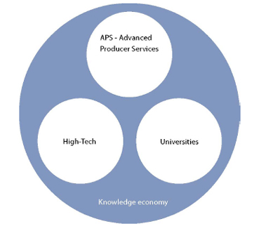
Figure 1: Structure of the knowledge economy. (Source: Thierstein et al., 2006). Within the space of flows the growing knowledge economy has been identified as a major development driver (Raspe, van Oort 2006; Thierstein et. al., 2006). Knowledge economy as defined by Thierstein is an interdependent system of APS firms, High-Tech industries and knowledge creating institutions such as universities and research establishments (figure 1). Combining science based knowledge and operating experience is characteristic for innovation and thus for the knowledge economy. The exchange of knowledge to a large extent requires geographical, social and cultural proximity, which at the core is based on personalized face-to-face interactions (Saxenian 1991; Oinas 2000; Torre, Rallet 2005). In this context we have to differentiate between two categories of knowledge: Codified knowledge and tacit knowledge (Polanyi, 1964). While codified knowledge can be easily standardized and replicated, the transfer of tacit knowledge requires contacts in person. Therefore "[ ] tacit knowledge is localized in particular places and contexts" (Malecki, 2000:110). The described "local nature of knowledge" (Malecki, 2000) forms the basis for several studies on location strategies of knowledge economy firms, which aim to identify non physical global firm knowledge flows and networks. Peter Taylor developed an empirical research method, to quantitatively identify inter-locking firm networks and measure the non physical connectivity of cities by analyzing intra-firm company networks (Taylor, 2004). He used the networks of Advanced Producer Service (APS) firms, one pillar of the knowledge economy, to come up with a ranking of world cities regarding their connectivity degree. An analysis of the location behavior of knowledge-intensive economy (KIE) firms is also part of the research project described in this paper. The focus of the analysis in this case lies on the following two pillars of the knowledge economy: Advanced Producer Services (APS) firms and High-Tech firms. In the paper we will refer to these two sectors with the term knowledge-intensive economies (KIE). Universities and academic research institutions are omitted in this context since these institutions do not in general display a very dynamic multi-branch, multi-location behavior like the otherwise private firms in the APS and High-Tech sectors. We have defined KIE on basis of the international NACE classification (Nomenclature générale des activités économiques). Table 1 shows the lines of businesses, which have been included in the empirical research.
Table 1: Overview of studies knowledge-intensive economy sectors. (Source: Authors). Another highly influential researcher in the area of relational geography is Saskia Sassen. She showed, that knowledge-intensive head offices of APS firms are mainly located in core metropolitan regions, which act as nodal points within an international network of cities. In 2001 she identified New York, London and Tokyo as the "global cities", which are prioritized locations for a large share of APS firms (Sassen, 2001). However, the geo-strategic role of regions as well as cities changes over time. Wallerstein presented an analysis of the emerging world system and the core mechanism of the European capitalist trade system (Wallerstein, 1974). Thus the world capitalist system is organised in three parts: (1) the core areas European territorial entities or states for a long time have been the core of the world economy; (2) The peripheral areas, that have been exploited to supply cheap labour and natural resources and were markets for surpluses of the core area; (3) the semi-peripheral areas that always acted and do so today mediate in the sense of transaction services between the former two areas. Wallerstein's analysis later evolved into functional network concepts like Global Commodity Chains', World City Networks' or Global Production Networks' (Coe et al. 2008). Furthermore, history shows, that cities can gain and loose their significance within the global city network. This is simply a question of time. As Peter Dickens outlines (Dickens, 1998), the world economy follows long waves of economical up- and downturns. Driven by radical innovations these economic cycles influence the functional hierarchy of cities. The growing importance of cities on the Arabian Peninsula from a relational geography point of view is evidence of Dickens theory. Urban Development in an Economic Context and Definition of Urban SpaceEconomic change historically seen has had an impact on urban development and urban space. Europe, for example, has faced its highest emergence of new cities back in the 13th century, when technical inventions in the agricultural sector and a flourishing trade economy have stimulated growth (Gross et al., 2004). Another example for the impact of economic change on urban development and planning is the industrialization age. Industrialization created the demand for a city wide spatial segregation of urban functions. Ebenezer Howard developed the garden city as a segregated place for living with low density (Howard, 1902). However, the functional division, as manifested in the Charter of Athens, as well as the low density degree in certain city spaces created disadvantages like an increased commuting traffic and the loss of city enlivenment around the clock. These factors later on lead to the postulation of traditional city spaces with a high degree of functional intermixture and density by Jane Jacobs (Jacobs, 1993). But not only historic examples show, that economic change has an impact on urban development and urban space. Nowadays the growing knowledge economy strengthens the role of cities as nodal points of exchange for tacit knowledge within the global space of flows. But how can cities fulfill the requirements of a globally connected location and what exactly are the requirements of the knowledge economy towards urban space? A closer look at emerging cities on the Arabian Peninsula is expected to help in answering this question. These cities have been free of boundaries from the above described historic urban developments, as their history of ascension is still very young. Dubai for example developed in a very short timeframe from a small fishing village to a global city attracting international knowledge economy firms. While in 1950 it still was a small town with no more than 20.000 inhabitants, it is a global hub with more than 1,5 million inhabitants today (United Nations, 2004). Besides Dubai several other emerging cities on the Arabian Peninsula have developed to highly attractive locations for the knowledge economy in the last decades. If we want to analyze the impact of the growing knowledge economy on urban spaces, we need to define the term urban space first. We can look at space from different perspectives. Complex scientific theories about space underline this. Henry Lefebvre outlines three different angles, to observe space: Space is lived, perceived and conceived (Lefebvre, 1991). On the one hand side we live in space, which means that space is the basis for our social interactions. But space is also a physical, materialized surrounding, which we perceive with our senses. Finally, space is conceived in the sense of how architect, politics, scientists and others theoretically think about the outline of space and act upon the physical space as designers and planners. These three perspectives of space need to be considered, if we want to analyze space in a comprehensive way. Therefore our methodological research approach will also reflect the described perspectives, which will be presented later on. Talking about urban space from any of the above mentioned perspectives, we have to consider three different dimensions of space (Boesch, 1989): First, the dimension of distance, which reflects the proximity and availability of urban functions as well as the density of buildings, people and inhabitants. Second, the dimension of functionality which consists of the existence of urban functions, the degree of functional diversity and the morphology. Morphology is defined as the sequence of open and close spaces, the sequence of public and private spaces and the building types (e.g., high rise, one-story solitaire building). Third, the dimension of process which considers the urban development over time and the agents involved in the urban development and planning process. Bridging the Gap between Existing Research: The Three Central HypothesesWe have so far given some background on the two scientific areas of relational geography and physical urban development. In order to answer our central research question regarding the impact of emerging Arab cities` global significance on the development of local urban space in the context of a growing knowledge economy, we have to bring the two scientific approaches together. The relational geographical analysis of emerging cities will give us a global functional perspective on the emergence of cities on the Arabian Peninsula, while a physical urban development analysis will compensate that from a local view point. In this way we can test the following three central research hypotheses:
The third research hypothesis focuses on Western-Europe, since the authors of this paper are of Western-European origin. However, theoretically the third hypothesis can also be applied to any of the so-called developed regions other than Western-Europe. METHOD TRIANGULATION AND DEFINITION OF STUDY AREAThe method triangulation developed and applied in the described research project proposes a applicable empirical approach for a systematic analysis of local urban space development in a global context. As outlined before, our methodological approach reflects the three perspectives of urban space described by Lefebvre (Lefebvre, 1991). The method triangulation therefore consists of three complementary research methods:
The three research methods are conducted in the above described sequence. In the following we will describe the research methods in greater detail, outlining the expected results of the methods and their benefit of combination. Survey with Knowledge-intensive Economy (KIE) Firms (Lived Urban Space)Target of this method is, to develop an understanding for the following three factors: 1. The importance of emerging cities with respect to its non-physical connectivity degree (globally and in relation to other locations on the Arabian Peninsula) based on KIE firm location descriptions, 2. The location criteria of emerging cities globally attracting KIE firms and the relevance of local facilities for KIE city location selection, 3. The requirements of KIE firms regarding urban space. An online survey is used for a broad, quantitative evaluation of these factors. Interviews with managers and board members of KIE firms qualitatively validate the results of the online survey. Zawya as one of the most exhaustive company databases in the Middle Eastern region is used to source firms for the online survey participation. A link to the online survey is sent via e-mail to all firms, which fall into the NACE code classifications of KIE defined above. In this way we reach out to a large amount of firms with low effort. However, the response rate of sending out survey invitations via an anonymous e-mail is very low (around 1%). Therefore this broad range invitation is combined with personalized e-mail invitations to company managers sourced by online business networks (such as the global business network Xing or smaller local business networks). Personalized invitations usually reach out to a smaller range of people, since the effort of sourcing potential survey participants one by one is rather high. However, the response rate of sending out personalized invitations is around 20%. Interview partners for the qualitative validation of survey results are selected from the sample of survey respondents. The criterion for selection is to achieve a variety of KIE firm interviews from different lines of businesses, company sizes and globalization degrees. The following benefits from this method are created for the on site observation, the second part of the method triangulation: The local facilities influencing the global KIE location selection as a result of the KIE survey can be compared with the existing local facilities in emerging cities. Furthermore, the dimensions of urban space required by KIE can be compared with the existing dimensions in specific KIE relevant districts within the cities. Finally, the distribution of KIE business buildings across emerging cities can be explored through the business building location indication of survey respondents. That information is useful to identify potential city districts with a high accumulation of KIE firms for the following observational research in specific KIE relevant urban spaces. On Site Observation of Urban Structure and Space (Perceived Urban Space)Target of this method is, to get an understanding of the overarching urban structure of emerging cities on the Arabian Peninsula and to analyze in detail urban spaces in specific KIE relevant city districts. We can finally compare the resulting knowledge gained on the existing city structure and spaces with the requirements of KIE regarding urban space. The method combines a broad graphical urban structure analysis of the whole city space with a deep dive analysis of specific city spaces with a high relevance for KIE businesses. The broad graphical urban structure analysis includes a graphical allocation of KIE business buildings across emerging cities. Furthermore, we outline the distribution of urban functions, the building and inhabitant density as well as the degree of functional diversity in city ground plans and sections. The deep dive analysis in one specific urban space per analysed emerging city allows a closer look at an urban space with a high relevance for KIE firms. This analysis is conducted via behavioral mapping in combination with photographic observation. The used place-centered behavioral mapping method describes "how people use a specific space" (Dohr, Guerin, 2008: 4). Via using this tool we can describe the density and type of people as well as the use of available urban functions in specific urban spaces in a defined time period. We conduct behavioral mapping sessions combined with photographic observation in a city space of approximately 300 square meters on two different days: On a working day and on a weekend day. During these two days we observe the selected urban space for a total time period of 10 minutes seven times a day: In the early morning between 5 am and 8 am, in the forenoon between 8 am and 11 am, at noon between 11 am and 2 pm, in the afternoon between 2 pm and 5 pm, in the early evening between 5 pm and 8 pm, in the late evening between 8 pm and 11 pm and at night between 11pm and 5 am. The criteria for selection of the respective city space and perspective for behavioral mapping in combination with photographic observation are the following:
The results of the broad graphical urban structure analysis and the in depth behavioral mapping analysis of specific urban spaces describe the qualities of urban space in emerging cities. These qualities are finally compared with the requirements of KIE regarding urban space. The overlap of existing urban qualities and urban requirements from a KIE perspective defines the degree of KIE satisfaction with the local urban spaces. The following benefits from the on site observation method are created for the content analysis of planning process and material, the third part of the method triangulation: The KIE satisfaction degree with the local urban spaces can be compared with the relevance of urban planning objectives, to design KIE attractive city spaces. Furthermore, planning process and objectives in emerging cities on the Arabian Peninsula can be evaluated with respect to the qualities of the existing urban space in a knowledge economy context. Content Analysis of Planning Process and Material (Conceived Urban Space)Target of this method is to understand the process and objective of planning urban space in emerging cities on the Arabian Peninsula and its compatibility with the requirements of KIE firms. We can achieve this by using two tools: A graphical urban structure analysis over time and interviews with planers from different institutions involved in physical urban planning. The graphical urban structure analysis over time is used to analyze when KIE relevant urban spaces developed. In this way we can reflect the timeframe, in which emerging cities developed highly attractive urban spaces for KIE firms. In order to understand the guiding principles and objectives in developing KIE attractive urban spaces as well as the organizational setup of city planning we conduct interviews with key persons in charge of urban planning. The favorability of planning objectives for KIE attractive urban spaces as well as regulatory conditions for ensuring the objectives of urban planning in the context of creating KIE attractive urban spaces are evaluated. In addition, the interviews are leveraged to create an organizational chart of the institutions and offices involved in urban planning within emerging cities, as the organizational structure is expected to have a large impact on the pace of urban development in emerging cities. In a city, which fully answers the needs of the knowledge economy in terms of urban space, the results of the method triangulation would show that the observed qualities of urban space and urban space expectations of KIE firms are identical. Since emerging cities on the Arabian Peninsula have developed into highly attractive KIE locations in a very short timeframe, these cities are expected to come close to an ideal KIE location at least in certain dimensions. We finally transfer findings from emerging cities on the Arabian Peninsula to cities in so called developed regions such as Western Europe. Potential learning areas can be outlined along three dimensions:
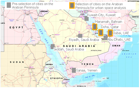
Defining the Future Study Area: Three Case-study Cities on the Arabian PeninsulaThree case-study cities on the Arabian Peninsula have been selected, to which the method triangulation will be applied. A comparison of results across all case-study cities will enable us to determine the validity of our initial hypotheses on a broader basis. The selected case-study cities are Dubai (UAE), Doha (Qatar) and Manama (Bahrain). The following criteria have been used for selecting the set of case-study cities:
For the purpose of evaluating emerging cities on the Arabian Peninsula on basis of these criteria a pre-selection of cities has been made. We have pre-selected seven cities on basis of the Top 200 "World City network" ranking (Taylor, 2004) which outlines the best connected cities within the global network of advanced producer service firms. Figure 2 shows a map of the Arabian Peninsula highlighting the preselected cities and the finally selected case study cities.
Figure 2: Map of Arabian Peninsula, highlighting the preselected and finally selected case-study cities. Source of map: http://www.baghdadmuseum.org/maps/me2003.jpg (downloaded at 24th of April 2008, adapted by the authors). PRELIMINARY RESEARCH RESULTS FROM DUBAISo far we applied the method triangulation to one out of the three selected case study cities: The city of Dubai. In this chapter we summarize the preliminary findings and research results. In parallel we discuss the initial research hypothesis. Dubai and its Status in the Global Network EconomyTo elaborate on the status of Dubai in the global network economy an online survey with 98 knowledge intensive economy firms (78 APS and 20 High Tech firms) and 10 qualifying interviews were conducted. The following multi-layered results were gained in Dubai:
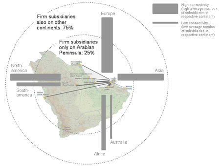
Figure 3: Global non physical KIE firm network connectivity of Dubai. (Source: Authors).
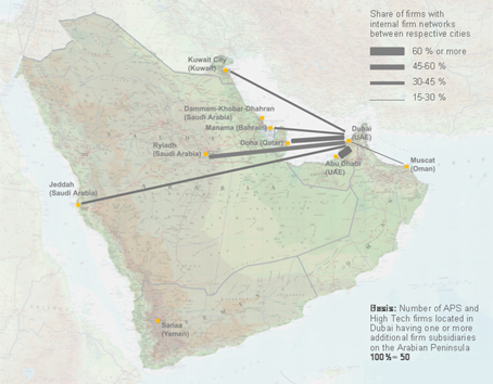
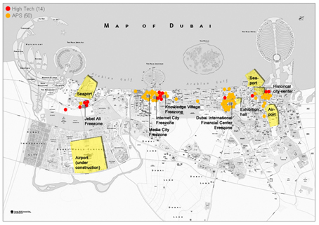
Figure 4: Non physical KIE firm network connectivity of Dubai to other Arab cities. (Source: Authors). The above mentioned survey results serve as a preliminary verification for our first hypothesis: The significance of Dubai within the global KIE city network is a result of rapid KIE growth in the latest years due to various location-specific development forces. Final and full appreciation of the results of course is possible only after having finished the entire empirical study. Requirements of KIE Firms Regarding Urban Space in Dubai and Actual Urban SpaceThe online survey with knowledge-intensive economies (KIE) has disclosed the distribution pattern of firm locations across the city of Dubai as well as the KIE firm requirements regarding urban space. The distribution of firm locations across Dubai (figure 5) shows that KIE firms are mainly accumulated around the following city districts: Dubai International Financial Center (DIFC), Knowledge Village, Internet City, Media City and Jebel Ali free zone. DIFC is the district with most KIE firm location indications. The basis for figure 5 were 64 out of 98 survey responses (50 APS and 14 High Tech firms) who provided information about their business building location in Dubai. The described city districts are free zone areas. Free zone areas are specifically designed to attract firms of certain sectors to Dubai. Advantages of being located in such zones are exemption from taxation combined with a high facility, infrastructure and maintenance quality. The ease of market entry, which is one major criterion for selecting the city of Dubai as a company location, is increased tremendously through such city districts. City spaces like DIFC are internationally visible through adequate marketing. Not only the characteristics of the city as a whole are relevant for global KIE firm location selection: In particular the attractiveness of selected city spaces in a city like Dubai which specifically answer the needs of KIE firms influence global firm location selection.
Figure 5: Map of Dubai indicating KIE business building locations. Source of map: Requirements of KIE in respect to urban space have been articulated in the online survey as well as in the interviews with KIE managers. The major findings are:
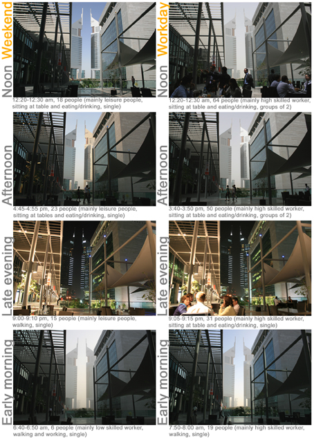
Figure 6: Behavioral photography-based mapping and observation in DIFC on 18th/19th and 21st/22nd of April 2008. (Source: Authors). Our initial second hypothesis has been shown to be provable on a city district scale. However, looking at Dubai from an overarching perspective, the city currently lacks certain factors to be and remain attractive for knowledge workers on a long-term basis. Planned Urban Space in Dubai in the Context of a Growing Knowledge EconomyThe objectives of "turning Dubai into a vibrant science and technology hub" and "attracting and retaining highly skilled employees" are outlined in the Dubai Strategic Plan 2015 (Dubai Strategic Plan 2015, 2007: 22). Satisfaction of KIE with urban space in Dubai can be seen as one enabler for reaching the above described objectives. Interviews with major organizations involved in urban planning in Dubai helped to elaborate on the satisfaction degree of KIE with urban space. Planners gave reasons for the KIE perception of well designed city districts, which however are described as being disconnected on an overarching city level: Semi-governmentally owned organizations (Emaar, Dubai Holding, Nakheel) supported by several private firms have been responsible for the design of city zones in Dubai during the last decade. Cutting the city into zones partly with specific functions attached (Dubai structure plan, 2003) has helped to attracted foreign investment for specially marketed city areas and has increased the pace of city development through parallel planning approaches. The missing link of city areas is seen as a disadvantageous consequence of that development. The Urban Planning Committee and the supporting consulting company Urbis currently work on an urban master plan 2020 for Dubai. Addressing the requirements of KIE regarding urban space as outlined in the KIE survey results in this context should be seen as one success factor for strengthening the city of Dubai as an attractive location for the knowledge economy. In addition, collaborative planning approaches of Dubai and neighboring functionally connected cities on the Arabian Peninsula (figure 4) could enrich urban planning from a regional, normative perspective. CONCLUSION AND RESEARCH OUTLOOKThe application of the newly introduced method triangulation in the case of Dubai has shown that the used methodological approach is a highly useful tool to comprehensively examine local urban spaces in a global context. The combination of methods has proven to be a successful way to test hypotheses from different viewing angles. Only through the multi-layered perspectives taken into consideration the research can describe the complex character of urban space. Dubai has gained global significance through the growth of knowledge-intensive economies. Globally visible, KIE attractive urban spaces on a city district scale contribute besides other factors to the global attractiveness of the city for KIE firms. These urban spaces fulfill the requirements of KIE firms in respect to their business building location. However, Dubai from an overarching city perspective has deficits in certain areas such as the disconnection of city districts leading to infrastructural problems as well as the unavailability and poor quality of leisure and recreational facilities. These areas pose a threat for the talent market in the knowledge economy sector of the city. In the further proceedings of the ongoing research project we will apply the method triangulation to two other cities on the Arabian Peninsula: Doha (Qatar) and Manama (Bahrain). We will compare the results to the preliminary findings gained in Dubai. After we will have conducted our research in all three cities, we will evaluate our initial hypotheses. Finally we will transfer our findings from the observed emerging cities on the Arabian Peninsula to western European cities. The final outcome of this research project is seen to be valuable for a number of different organizations such as governmental and educational institutions dealing with urban planning and development in Arab and Western European locations, representatives from global knowledge-intensive economy firms as well as people with a personal interest in regional and urban planning and development in locations on the Arabian Peninsula. ACKNOWLEDGEMENTSSpecial thanks to professors providing local technical support and advising on the Arabian Peninsula: Ashraf Salama, Ali Alrouf, Yasser Elsheshtawy.
REFERENCESCastells, M. (1996). The Information Age: Economy, society and culture, Blackwell Publishers, Malden, USA. Castells, M. (1999). "Space flow." In Boomann, J. (Ed.), Kursbuch Stadt. Stadtleben und Stadtkultur an der Jahrtausendwende, Stuttgart, Germany, p. 39. Coe, N., Dicken, P., Hess, M. (2008): Global production networks: realizing the potential. In: Journal of Economic Geography 8: 271-295. Dicken, P. (1998). Global Shift: Transforming the World Economy, Paul Chapman, London, UK Dohr, J., Guerin, D. (2008). A research tutorial by InformeDesign, Part III: Research Methods. http://www.informedesign.umn.edu/_doc/Research_101_Part_III.pdf. Downloaded on May 16th, 2008 Dubai Strategic Plan 2015 (2007). http://egov.dubai.ae/opt/CMSContent/Active/CORP/en/Documents/DSPE.pdf. Downloaded on May 13th, 2008 Dubai structure plan (2003). http://www.gis.gov.ae/portal/page/portal/GIS_PORTAL/E-STORE/FreE-Maps/Structure%20Plan.pdf. Downloaded on May 16th, 2008 Gross, G., Haerendel, U., Hoffmann, L., Lehmbruch, H., Scholz, F., Selig, H. (2004). Muenchen wie geplant, Franz Schiermeier Verlag, München, Germany. Hall, P., Pain, K. (Ed.). (2006). The Polycentric Metropolis. Learning from Mega-City Regions in Europe. Earthscan. London, UK. Howard, E. (1902). Garden Cities of Tomorrow, Faber and Faber, London, UK. Jacobs, J. (1993). The Death and Life of Great American Cities, New York, USA. Lefebvre, H. (1991). The Production of Space, London, UK. Malecki, E. J. (2000). "Creating and Sustaining Competitiveness. Local Knowledge and Economic Geography." In Bryson, J., Daniels, P., Henry, N., Pollard, J. (Ed.), Knowledge, Space, Economy, London, UK, New York, USA. Oinas, P. (Ed.). (2000) Distance and Learning: Does Proximity Matter? Knowledge, Innovation and Economic Growth. Cheltenham: Edward Elgar Publishing Inc. Polanyi, M. (1967). The tacit dimension, Loutledge & Kegan Paul, London, UK. Raspe, O., Van Oort, F. (2006): The Knowledge Economy and Urban Economic Growth. In: European Planning Studies 14(9): 1209-1234. Sassen, S. (2001). The Global City: New York, London, Tokyo. 2nd edn. Princeton, NJ, USA. Saxenian, A. (1991): The origins and dynamics of production networks in Silicon Valley. In: Research Policy 20(5): 423-437. Taylor, P.J. (2004). World City Network: A Global Urban Analysis, Routledge, London, UK. Thierstein, A., Kruse, C., Glanzmann, L., Gabi, S., Grillon, N. (2006). Raumentwicklung im Verborgenen. Die Entwicklung der Metropolregion Nordschweiz. Zürich, Switzerland. Torre, A., Rallet, A. (2005): Proximity and Localization. In: Regional Studies 39(1): 47-59. United Nations (2004): World Urbanization Prospects, 2003 Report. New York, USA. Wallerstein, I. (1974): The modern world-system: capitalist agriculture and the origins of the European world-economy in the sixteenth century. Academic Press, New York /San Francisco/London
NOTE* Alain Thierstein and Elisabeth Schein, Munich University of Technology, Chair for Territorial and Spatial Development, Germany. Email: thierstein@raumentwicklung.ar.tum.de, schein@raumentwicklung.ar.tum.de
Note: This Research Bulletin has been published in Archnet-IJAR: International Journal of Architectural Research, 2 (2), (2008), 178-195 |
|||||||||||||||||||