GaWC Research Bulletin 16 |
|
|
|
This Research Bulletin has been published in Tijdschrift voor Economische en Sociale Geografie, 91 (2), (2000), 176-189.
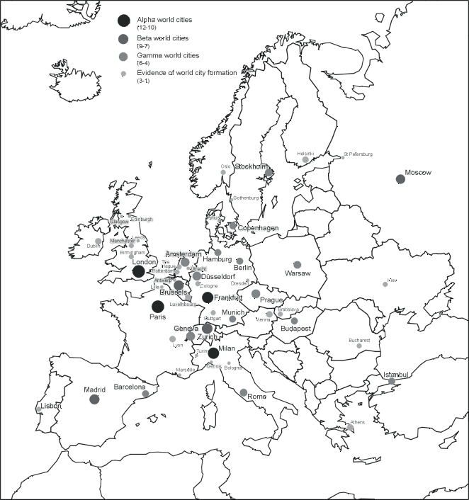
... major cities throughout Europe constitute the nervous system of the economic and political body of the continent. The more nation-states wane, the more cities emerge as the driving force in the making of a new European society. (Castells 1993, p. 250) According to Castells (1993, p. 247), cities are inherently complex entities. This is because they are the result of ever-changing structural determinants interacting with multiple specificities rooted in culture and history. Capitalist restructuring since the crisis of the 1970s has produced the latest structural determinants, collectively termed globalization, which have created new world cities (Friedmann 1986) or global cities (Sassen 1991). However that is only part of the story. In addition, the historical and cultural specificities are not constants; their influences on city development alter as changing economic and political circumstances bring forth new meanings for old practices. For instance, Castells (1993, p. 256) deems the particular historical tradition of European cities to be 'strategically important for the next stage of urban civilization'. In short, to understand economic restructuring with its urban preconditions and consequences research must be sensitive to the geography of change: globalization is very regional in nature. The regionality within globalization is the main finding of a study of world cities (Taylor and Walker 1999) upon which this paper is built. Using a roster of 55 world cities defined in terms of their advanced producer services (Beaverstock et al. 1999), the office geographies of 46 major service firms were analysed to create a typology of world cities. Broadly speaking, the 22 European cities in the world city roster tended to group together but not into one 'European cluster' - European cities appear in six different groups, three of which are solely European and three show American linkages. These results confirm distinctive European dimensions within the world city network while also problematising the notion of a singular European world city type. To explore this further, in the research reported here we replicate the analysis of the world-wide study but for just European cities. We add 31 cities which have evidence of world city formation (Beaverstock et al. 1999) to the 22 European world cities in the original analysis to produce fresh results covering 53 European cities. We create a new typology of five basic groupings of European cities. At first glance, our results contradict Castells' use of the term 'European cities' as a generic category of world city. In fact a close reading of Castells (1993) indicates that when he identifies the specificities of European cities he is not thinking in simple continental terms. Despite the title of his paper, at one point he does specify 'Western European cities' (p. 247) as the subject of his arguments and he concludes with a discussion of the civil societies of European cities (p. 256) which is certainly not Europe-wide in scope. In fact his description of '(t)he tradition of European cities as city-states' (p. 256) is very specific within Europe: it is evocative of Rokkan's (1970) famous spatial model of European economic and political development. This geohistorical framework identifies a city-studded Europe as the central economic spine of the continent running from the Baltic through the Low Countries and Rhinelands to northern Italy. This 'Europe' is deemed to be culturally and politically different to the other 'Europes' located to its west and east. Castells is not concerned with such spatial order within Europe but his argument for specificities obviously is not restricted to the world regional scale. As always, there are 'regions within regions' and our analysis depicts a pattern reminiscent of Rokkan's historical division of Europe. Our typology defines a new spatial order of European cities, a new mapping under conditions of contemporary globalization. The paper is divided into four parts. We begin with a review of how others have viewed the spatial order of Europe to set the Rokkan model in its overall context. We note in this review how many of the concepts appear to derive from a simplistic empiricism, little more than eye-balling uni-variate maps. In contrast our study is empirically rich and statistically rigorous: in the second section we describe our data matrix - 46 firms by 53 cities - and multivariate methodology - principal components analysis. If indeed cities are as complex as argued above then they deserve to be studied at this sort of level of evidence and analysis. Our results showing a five-fold typology depicting a 'spinal' spatial order are described in detail in the third section. In the concluding section, implications of our findings for both Castells' (1993) arguments and the source study (Taylor and Walker 1999) are discussed through interrogating the idea of 'a Europe of cities'. THE ECONOMIC SPACES OF EUROPEDuring the Cold War the space of Europe was reduced to a simple political division with profound economic consequences. If cities were mentioned in this context it was as capital cities, NATO capitals such as London and Bonn versus Warsaw Pact capitals like Warsaw and Budapest all doing the bidding of their respective Washington and Moscow superiors. In many ways the Cold War can be seen as the culmination of the rise of territorial nation-states which threatened to eclipse cities as autonomous economic motors in the modern world (Taylor 1995). But under conditions of globalization cities are again being appreciated for their wider economic prowess, for their traditional role in linking together the world-economy. The contemporary expression of this process is world city formation where cities strive to articulate their local regional economies into a new global economy. At the head of this process are the global cities - London is always so identified for Europe - which have a world-wide economic scope. Nation-states have defined a territorial mosaic of economic spaces, their 'national economies', but even the most autarchic policies have not been able to hide the economic inter-connections which transcend state boundaries. This trans-stateness has been expressed as economic spaces which do not respect 'national economies' but rather define broader economic regions. These are commonly organised hierarchically in a core-periphery format. In Europe these economic spaces have been variously defined by the presence/absence of modern cities and modern industry. Cores and PeripheriesSystematic uneven economic development in Europe is traced back to the eleventh century by Braudel (1984, p. 92) who identifies a 'first European world-economy' in the high middle ages. This was a collection of 'city centred economies' defining an axis orientated by 'two poles' (p. 96), a northern complex organised around the Hanseatic League of cities and a southern concentration based upon the city states of northern Italy (p. 113, Figure 13). Rokkan (1970; 1980; Rokkan and Urwin 1983) has argued that this city-centred European spatial order continued through the early modern period to have a profound effect upon modern polities and economies. In his model the city axis defines an east-west economic division of Europe which he combines with a second cultural division distinguishing northern (protestant) from southern (catholic) geographical zones. However, since the early modern period it can be argued that these two geographical axes have been fundamentally altered and have even swapped natures: industrialization created a north-south economic division and, more recently, the Cold War created an east-west cultural division. Clearly, we cannot assume unproblematically a continuity in the spatial order of Europe with major cities forming a core 'spine'. For Wallerstein (1974, 1980) the medieval spatial economic order was disrupted by the emergence of the European-centred capitalist world-economy in the 'long sixteenth century' which culminated in the rise of Braudel's northern pole and Dutch hegemony. In Wallerstein's world-systems approach, the Low Countries and other northern areas accumulating capital from the new Atlantic trades (North Sea Germany, England, Atlantic France) form the first core region of the modern world-system and Mediterranean Europe, including northern Italy, is relegated to semi-peripheral status (see discussions in Nitz 1993). It is this north-south economic contrast that is hugely accentuated by industrialisation, and which, as Pollard (1973) has shown, was not a national process but was transnational from its inception with its early penetration of the lower Rhinelands. With core-periphery in Europe equated with presence-absence of modern industry, the spread of industrialisation into east-central Europe and even Mediterranean Europe (a belt running from Catalonia to northern Italy) has meant that the area defined as core has increased appreciably since Dutch hegemony. In the twentieth century this has come to include a large swathe of territory from southern Scandinavia to the northern shores of the Mediterranean. Rokkan and Urwin (1983, p. 43) illustrate this by comparing the boundaries of 'the European core' as depicted by Delaisi (1929) and Seers (1979). They remark on the similarities between the two maps fifty years apart, despite that half-century involving massive political disruption in Europe (p. 42). The only significant change in economic spatial order shown by these maps is the removal of Soviet-bloc industrial areas (in East Germany, Czechoslovakia and western Poland) from the European core. With the demise of the Soviet bloc since Rokkan and Urwin invited this map comparison exercise, it could be suggested that we can now reinstate these industrial parts of central Europe to core status so that the economic spatial order of Europe ends the century very much how it began it. Such an historical continuity is not a good suggestion. Economic changes have meant that industry is no longer a simple index of core-ness. In fact with the industrialization of third world countries a new international division of labour has developed (Fröbel et al. 1980) in which much industrialisation is becoming a mark of semi-peripheral status (Arrighi and Drangel 1986). In contrast the rise of the service sector (Daniels 1993) has meant that cities have returned as a way of conceptualising core-ness. This means much more than a change in criteria, cities cannot be fully understood except as nodes in a space of flows. Core as industrial region tended to be defined territorially by the attributes of an area, with core viewed in terms of city networks the concept returns quite explicitly to Wallerstein's (1979) original conception of it as a relational concept. In the case of Europe this has resulted in rediscovery of Rokkan's city spine as the core of the new spatial economic order. Bananas and GrapesWith the development of a single European market and a perceived increase in competition between European cities, several attempts have been made since the late 1980s to map the changing economic space of Europe in terms of cities (for reviews see Shachar 1996; Wegener 1995; Kunzmann 1992, 1998). Most studies show a preoccupation for defining new urban hierarchies, either by combining a variety of functional indicators (e.g. Brunet 1989; Cattan et al. 1994) or by focussing on selected topical variables (e.g. Meijer 1993; Rubalcaba-Bermejo and Cuadrado-Roura 1995). Partly as a by-product of these studies, partly as the sole focus of attention, the geographical representation of new economic spaces in Europe has perhaps shaped the perception of policy makers deeper than the various league-tables produced. One of the most enduring cartographic images of the spatial order of cities in Europe is the so-called 'dorsal' or 'blue banana', first mapped before the coming down of the Berlin Wall in a study for the French regional planning authority DATAR (Brunet 1989). Originating from a typology of 165 European cities, the concluding map depicts a dominant urban axis from London to Milan (the 'blue banana'), including the cities of the Randstad and West Germany, but notably excluding Paris and most of France. A secondary belt of urban activity, a 'European sunbelt' or 'golden banana', stretches from Madrid and Barcelona across the Provence to Northern Italy. The original 'banana' map, partly an expression of the intention to highlight the dominance of Paris within France and point to the lack of other cities of European economic importance (Kunzmann 1992, p. 34), gave rise to various modifications, shaped by the desire to belong to the perceived European core area of economic development. In France, a 'L'Arc Nord Est' was defined, a 'French banana' promoted by the government to counter German economic influence (Kunzmann 1992, p. 34). In Germany, one scenario added a hump to the original banana to include Hamburg, another defined a second North-South axis (Kunzmann aptly calls it 'cucumber') promoting a future dynamic zone from Lübeck and Rostock to Budapest, optimistically assuming positive economic effects for the area between 'banana' and 'cucumber' (i.e. the rest of Germany, Austria and the Czech Republic) (see Kunzmann 1992, p. 35). Similar scenarios have been developed from a Central European perspective, notably a Central European 'boomerang' including Gdansk, Poznan, Wroclaw, Prague, Brno, Bratislava/Vienna and Budapest (Gorzelak, 1996, pp. 127-129). The most inclusive graphic description of European spatial structure takes the form of 'Japanese corridors' (see Kunzmann 1992, p. 37) that have recently turned into a 'red octopus' (van der Meer 1998). These simplistic spatial pattern models have been rightly criticised on several counts. The basic point is that although they are city-based, they still originate from 'traditional approaches of economic geography and regional analysis, that are focussed on attributes of areas, structural and locational factors rather than on spatial networks and relations and specific regional forms of interaction' (Krätke 1995, p. 136; translated by authors, emphasis in original; Krätke 1997, pp. 153-154; Shachar 1996). Furthermore, as the variety of different spatial metaphors available suggests, these images are based less on empirical evidence than on creative geopolitical imaginations: almost any space in Europe can be depicted as a potentially important European urban space (Kunzmann 1992; Dematteis 1997). Kunzmann and Wegener (1991, pp. 63-64) therefore suggest we use a bunch of grapes - 'the European grape' - as a representational Leitbild for the development of urban Europe, stressing the polycentric structure of the European urban system. In a similar reaction to simple territorial patterns, Goddard (1995, p. 133) has argued that 'the corporate map of Europe may look more like a bowl of fruit salad than a banana'. While being sympathetic to the motives for such changes of metaphor, we do not adopt them for this study. Basically such polycentric structures can hide the centrality, or core-ness, which does inevitably exist in the European economic space of cities. Multi-cellular models hark back to Christaller's (1950) 'spatial order in Europe' based upon his abstract theorising of an even pattern of cities. Our analysis is much more in keeping with Dunford's (1998; Dunford and Perrons 1994) recognition of a grid of cities which he refers to as 'Europe's vital axis'. In terms of pattern, this is a return to Rokkan's original city spine which our analysis endorses. But ours is not another map drawing exercise, the city spine is derived from a large scale multivariate analysis. We attempt to overcome the noted deficiencies of existing spatial images - often an undertheorized mix of attribute data and an overstretched geographical imagination - by a rigorous empirical study using a set of data which embodies relations between cities firmly set within the theoretical framework of world city formation. DATA AND METHODOLOGYAs we indicated in the introduction, in this paper we replicate for European data, analysis previous undertaken at a world-wide scale. Both data collection and methodology are described in detail in the source paper (Taylor and Walker 1999; see also Beaverstock et al. 1999); below we present their essential characteristics in order to make this paper free-standing. This elementary description includes all the key points necessary to understand the subsequent analysis. Cities and FirmsThe cities we study derive from a large scale analysis of 263 cities across the world of which 142 were identified as places where world city formation processes could be detected. These were defined in terms of a city's importance as a service centre for a selection of advanced producer services (accountancy, advertising, banking/finance and law). A scale from 1 to 12 was devised; cities scoring 4 and above were deemed world cities and 55 cities qualified (Beaverstock et al. 1999). In addition this roster of world cities was divided into three strata of relative importance: 10 alpha world cities scoring 10 to 12, 10 beta world cities scoring 7 to 9, and 35 gamma world cities scoring 4 to 6. Europe was well represented in this analysis with 22 cities within the world city category (4 alpha, 4 beta, and 14 gamma) and a further 31 showing evidence of world city formation (i.e. scoring between 1 and 3). It is these 53 European cities which are the subject of our analyses below; they are illustrated in Figure 1. There are 46 producer service firms in our data. These are selected on the basis of having offices in at least 15 different cities. These 'global service providers' include accountancy, advertising, banking/finance and law firms; they are listed in the appendix. For each firm we have data on their presence in each city (Taylor and Walker 1999). Because of the variation in information available, this data is coded simply 3 for major office, 2 for medium office, 1 for minor office and 0 for no office. For a minority of firms we have just presence/absence data coded 1/0. The information for this study consists, therefore, of a 53 x 46 data matrix whose cells record office geographies of global service firms across European cities. Parsimony out of ComplexityThis matrix contains 2438 (=53 x 46) items of information. The family of factor analytic techniques are the standard statistical means of reducing large data matrices into interpretable dimensions of variability. We use the simplest technique of this group, principal components analysis (Taylor and Walker 1999). A principal components analysis derives new common patterns of variation ('principal components') by analysing correlation coefficients. In this case the correlations are between cities: if two cities have similar mixes of firms they will correlate highly. Principal components, therefore, represent groups of cities with similar mixes of firms. The relations between components and cities is shown by the component loading of each city on each component. These loadings can be interpreted as correlations between a city and a component. We define important loadings as above 0.7 and relevant loadings as above 0.4. In order to delineate clear clusters of cities we use the standard varimax rotation with the number of components to be rotated specified by their interpretability: every component must have at least one important loading (Taylor and Walker 1999). All relevant loadings are also recorded and it is these loadings which indicate clusters of cities 'loading high' on particular components (Taylor and Walker 1999). Indicating which firms are important for each cluster of cities is, unfortunately, not straightforward. Usually 'component scores' are computed for this task but these are problematic in our analysis for specification reasons. Basically because we have more cities than firms, a singular matrix is created which should not be used to calculate scores. Thus in the presentation of results below we provide no tables of scores but we do provide a general indication of which service sectors are particularly important for a specific grouping of cities. The basic purpose of principal components analysis is to create a parsimonious description of a data matrix. In the case of our analysis the variation measured by the distribution of firms' offices across 53 cities is reduced to five patterns of offices across 5 components each representing a cluster of cities. Of course there is a loss of variance in the reduction from 53 distributions to 5, the latter account for 68.9% of the original variation. However, statistically, this is a very good, parsimonious result: less than one tenth (5/53) of the initial number of distributions describes more than two-thirds of the initial overall variation. There are two further points to make about this form of analysis. First, the variance not accounted for by the five components can be interpreted as variation unique to particular cities no doubt reflecting the different histories of cities in relation to specific firms. What we are saying is that 31.1% (100 - 68.9) of the variance in our data is down to specificities at the city level: this is outside the common spatial order and therefore beyond our concern. Second, since all cities load on all five of the components it follows that it is possible for one city to have relevant loadings on more than one component. Hence our typology based on components is not a strict classification process: overlaps, cities in two clusters, can and do occur. This presents no problem, rather it enhances the analysis by showing that some cities are viewed as sharing characteristics of two clusters. The resulting spatial order is not a strict logical division, it is a more subtle statistical typology in keeping with the complexity of the subject matter. SPATIAL STRUCTURES OF CORPORATE SERVICE COMPLEXESWhat exactly do the principal components represent in this analysis? As we have indicated they bring together like cities, cities with similar mixes of corporate service provision in terms of firms' offices. Hence each component can be interpreted as a common service complex to be found within the designated cities, those with important and relevant loadings. These are the outcomes of major service firms location decision making; which cities they invest in for expensive office provision to service their customers in the European market. This paper focuses not on that decision making but rather on the outcomes, the five different corporate service complexes which define a typology of European cities. There is, of course, no statistical reason why the resulting typology of cities should have any particular geographical design. The degree to which there is a pattern shows that service provision decision making does not treat European space as an undifferentiated or random arena. Hence it is not just the fact that our results are so statistically impressive, they are also geographically elegant. The five components define categorical geographical patterns, a spatial order of European cities. This is a spatial order emanating from the decision making of corporate service firms but we will argue that it represents more than a particular empirical grounding, the location decision making is reflecting and reinforcing basic structures in Europe's economic geography. The results are shown in detail in Table 1 where all loadings over 0.4 are listed. Our geographical interpretation of these results is depicted in Figure 2 where cities are allocated to clusters on the basis of their largest loading. This defines a composite core-periphery spatial order: two service complexes are to be found in Europe's city spine and the other three pinpoint different regions of outer Europe. Europe's City SpineThe cities in the European spine are divided in terms of their importance as service providers. There are therefore two clusters of spine cities, minor and major. Minor spine cities are defined by the statistically most important component which accounts for nearly two fifths (39.3%) of the common variance. It incorporates 28 cities with loadings above 0.4. The important loadings reflect the whole north-south scope of the spine from Scandinavia/Baltic (Gothenburg) through the Low Countries (Rotterdam, Utrecht, The Hague, Antwerp), Germany (Hamburg, Cologne, Dresden, Stuttgart, Munich) to northern Italy (Bologna, Turin, Genoa). They form part of the third layer in many of the hierarchical functional classifications of European cities (see Dematteis 1997, Table 1, p. 92). Within our GaWC Inventory of World Cities most are classified as cities that show only some or minimal evidence of world city formation (Beaverstock et al. 1999, Table 7), but all German gamma world cities (Hamburg, Munich, Berlin, Dusseldorf) score on this component. The primary feature of the corporate mix generating this pattern is the relative importance of accountancy: the most globalised of all service sectors, the five firms in our data feature prominently in these central but minor cities. In addition there is evidence of a relative lack of banking in this corporate mix. Major spine cities are defined by a component accounting for just under a fifth (18.3%) of the common variance. It incorporates 19 cities with loadings above 0.4 but unlike in the previous component they are more concentrated in the lower levels. Nevertheless the pattern is clear: all of Europe's alpha world cities (London, Paris, Frankfurt, Milan) and three of the beta world cities (Madrid, Zurich, Brussels) are to be found loading on this component. The only beta world city without a relevant loading is Moscow, lying well outside the spine. The relatively low loading of London is noteworthy and is a point for further discussion later. Unsurprisingly, the corporate mix generating this pattern is dominated by the major presence of banking/finance firms. In addition the most global of law firms, Baker and McKenzie, is prominently featured in this corporate mix and appears elsewhere below suggesting that its location strategy in Europe is pivotal in this analysis. This is in keeping with the firm's pioneering role in globalising the least globalised service, law (Beaverstock et al. 2000). The Outer Regions of EuropeThere are three components which highlight cities beyond the spine. The cities fall into five distinct regions with three to be found in one component. The outer triangle of cities combines northern (Scandinavia/North Sea), south-western (Iberian/western Mediterranean) and south-eastern (Balkans/east-central Europe) regions in a single component. Covering 19 cities, this component is statistically the second most important accounting for just over a fifth of the common variance. Its triangular structure is epitomised by the three most important loadings: Copenhagen, Lisbon and Istanbul. The smallest cluster of cities is the south-west with Lisbon accompanied by low loading cities, Marseilles, Barcelona and Madrid. Istanbul is accompanied by Athens, Vienna, Prague, Bratislava, Budapest and Bucharest and Copenhagen by Stockholm, Amsterdam, Oslo, Dusseldorf, Arhus and Hamburg. The corporate mix defining this multifarious group of cities features a relative surfeit of advertising: since this sector serves 'national' markets, advertising firms locate themselves in leading 'national' cities, often state capitals. The cities selected here tend to complement the advertising with a relative dearth of banking and Baker and McKenzie is conspicuous by its absence. The eastern European (far east) cities are defined by the statistically smallest component accounting for 9% of the common variance. Only five cities load on this component with the two important loadings for the two most easterly cities in our data, Moscow and Kiev. The obvious city missing from this grouping is Budapest which may be a consequence of earlier economic transition from state to market economy. No western city rises above our threshold of 0.4; it is interesting to note, however, that Berlin (.358), London (.358) and Vienna (.371) come closest: old ties (Berlin, Vienna), and the major global city (London) involved in opening up the Soviet bloc to the world market (Taylor, 2000). The corporate mix featured here is quite varied with relative high levels of location for banking, accountancy and with Baker and McKenzie again featured: all sectors taking advantage of the new market opportunities consequent upon the collapse of the Soviet bloc. The British Isles (far west) cities is, perhaps, a more surprising regional cluster. This component accounts for 13% of the common variance and includes eight cities, all but the bottom two from the British Isles. With the exception of global London, all British and Irish cities in the analysis load on this component with four having important loadings: Birmingham, Edinburgh, Leeds and Dublin. The omission of London is obviously very noteworthy, as a global city it shares little similarity with other British cities, loading higher on the 'far east' than its home 'far west' region! The only continental European cities that share similarities in their corporate service mixes are the small transnational centres of Geneva and Luxembourg. The corporate mix itself features smaller (London) banks but with a relative dearth of advertising and no presence from Baker and McKenzie. In Figure 3 the cities which have relevant loadings on two components are shown in their second locations. This overlapping largely confirms our previous interpretations in terms of cities; for instance Prague and Bucharest overlapping between far east and the outer triangle with its south east region. However the main overlap is between the outer triangle and the two spine components especially in relation to the northern region. Amsterdam is identified with the major spine cities and three Scandinavian and two German cities overlap between minor spine and outer northern cities. This figure shows the advantages of a typology technique without definite boundaries: allowing North Sea cities to be both northern and spine is eminently sensible. CONCLUSION: A EUROPE OF CITIES?This paper has presented a typology of European cities which has turned out to be very geographically specific: we have created a spatial order of cities. It must be made clear that we cannot necessarily extend this analysis to discussion of urban systems and city hierarchies. Dunford (1998, pp. 53-54) is impressed by the historical continuity of Europe's urban axis which he relates to 'long term processes of circular and cumulative causation which have permitted the almost constant adaption to changing circumstances of established cities with critical concentrations of people, economic infrastructures, know-how and political power'. But these processes are not reinforcing a European system of cities. The current circumstances we have dealt with above are more than a return of service centres on a grand scale for the contemporary world-economy. Economic globalization has meant that all cities are evolving in new situations where adaptions have to be global. This is the reason the processes we have measured are designated world city formation. European cities are part of a wider system which is the world city network, Castells (1993, p. 250) refers to them as 'nodal centres of the new global economy'. We can show this in terms of our analysis by highlighting the cities which are least captured by our typology of five groups. Although all 53 cities feature in the typology (Table 1), the principal components analysis also provides communalities, which measure the degree that a city's variance is accounted for by the components. In other words, we can identify the 'un-European cities' which exist under the specific conditions of contemporary globalization in Europe. In fact, there are eight cities with noticeably low communalities, all below 0.6 (Table 2). They fall into two categories. First, there are four eastern European cities with local specificities which prevent them being very similar to other European cities, for instance Budapest's precocious turn to market economics before its erstwhile Soviet-bloc neighbours. Second, there are four international finance centres, including Europe's two leading world cities London and Paris, which have global specificities to prevent them being very similar to other European cities. London is the interesting example here. We have already noted that London is not very 'British' (Table 1), Table 2 shows it not to be very 'European' either. As Sassen (1991) has famously shown, London is a 'global city' and in our world-wide analysis (Taylor and Walker 1999) London's affiliation is most definitely with New York, and not with any other European city. Castells (1993, p. 256) concludes with a 'back to the future' scenario arguing that the European (spine) city tradition is a historical specificity which should serve Europe well in the new space of flows under conditions of globalization. Notice that this is not an argument for a Europe of cities in any systemic sense. Rather it says that, possibly, European civil society is best equipped to operate in a future globalised world of networks. This is the opposite of the notion of a Europe of cities within the European Union (EU) as a rival to the Europe of nation-states of which it is currently constituted (Harding 1997). As a territorial project, the EU is a most unsuitable political context for world cities. There is a spatial order to European cities as we have shown, but there can be no Europe of cities while globalization remains the context for world-region building. REFERENCESArrighi, G. and Drangel, J. (1986), The Stratification of the World-economy: An Exploration of the Semi-periphery Zone. Review (Fernand Braudel Center) 10, pp. 9-74. Beaverstock, J.V., Smith, R.G. and Taylor, P.J. (1999), A Roster of World Cities. Cities 16, pp. 445-458. Beaverstock, J.V., Smith, R.G. and Taylor, P.J. (2000), Geographies of Globalization: US Law Firms in World Cities. Urban Geography (forthcoming). Braudel, F. (1984), The Perspective of the World. London: Collins. Brunet, R. (1989), Les Villes "Européennes". Rapport pour la DATAR. Paris: La Documentation Française (RECLUS/DATAR). Castells, M. (1993), European Cities, the Informational Society, and the Global Economy. Tijdschrift voor Economische en Sociale Geografie 84, pp. 247-257. Cattan, N., Pumain, D., Rozenblat C. and Saint-Julien, T. (1994), Le Système des Villes européennes, Paris: Anthropos. Christaller, W. (1950), Das Grundgerüst der räumlichen Ordnung in Europa. Die Systeme der europäischen zentralen Orte. Frankfurt am Main: Frankfurter Geographische Hefte, 24. Daniels, P.W. (1993), Service Industries in the World Economy. Oxford: Blackwell. Delaisi, R. (1929), Les Deux Europes. Paris: Payot. Dematteis, G. (1997), Représentations spatiales de l'urbanisation européenne. In: A. Bagnasco and P. Le Galès, eds., Villes en Europe, pp. 67-96. Paris: La Découverte. Dunford, M. (1998), Economies in Space and Time: Economic Geographies of Development and Underdevelopment and Historical Geographies of Modernization. In: B. Graham, ed., Modern Europe: Place, Culture, Identity, pp. 53-88. London: Arnold. Dunford, M. and Perrons, D. (1994), Regional Inequality, Regimes of Accumulation and Economic Development in Contemporary Europe. Transactions, Institute of British Geographers NS 19, pp. 163-82. Friedmann, J. (1986), The World City Hypothesis. Development and Change 17, pp. 69-84. Fröbel, F., Heinrichs, J. and Kreye, O. (1980), The New International Division of Labour. Cambridge: Cambridge University Press. Goddard, J. (1995), Information and Communication Technologies, Corporate Hierarchies and Urban Hierarchies in the New Europe. In: J. Brotchie, M. Batty, E. Blakely, P. Hall and P. Newton, eds., Cities in Competition. Productive and Sustainable Cities for the 21st Century, pp. 127-138. Melbourne: Longman Australia. Gorzelak, G. (1996), The Regional Dimension of Transformation in Central Europe. London: Regional Studies Association. Harding, A. (1997), Urban Regimes in a Europe of the Cities? European Urban and Regional Studies 4, pp. 291-314. Krätke, S. (1995), Stadt - Raum - Ökonomie. Einführung in aktuelle Problemfelder der Stadtökonomie und Wirtschaftsgeographie. Basel: Birkhäuser. Krätke, S. (1997), Globalisierung und Stadtentwicklung in Europa. Geographische Zeitschrift 85, pp. 143-158. Kunzmann, K.R. (1992), Zur Entwicklung der Stadtsysteme in Europa. Mitteilungen der Österreichischen Geographischen Gesellschaft 134, pp. 25-50. Kunzmann, K.R. (1998), World City Regions in Europe: Structural Change and Future Challenges. In: F.-C. Lo and Y.-M. Yeung, eds., Globalization and the World of Large Cities, pp. 37-75. Tokyo, New York, Paris: United Nations University Press. Kunzmann, K.R. and Wegener, M. (1991), The Pattern of Urbanisation in Western Europe 1960-1990. Report for the Directorate General XVI of the Commission of the European Communities as Part of the Study 'Urbanisation and the Function of Cities in the European Community'. Dortmund: IRPUD. Meer, L. van der (1998), Red Octopus. In: W. Blaas, ed., A New Perspective for European Spatial Development Policies, pp. 9-26. Aldershot: Ashgate. Meijer, M. (1993), Growth and Decline of European Cities: Changing Positions of Cities in Europe. Urban Studies 30, pp. 981-990. Nitz, H.-J., ed. (1993), The Early Modern World-System in Geographical Perspective. Stuttgart: Franz Steiner Verlag. Pollard, S. (1973), Industrialization and the European Economy. Economic History Review 26, pp. 636-648. Rokkan, S. (1970), Citizens, Elections, Parties. New York: McKay. Rokkan, S. (1980), Territories, Centres and Peripheries: Toward a Geoethnic-Geoeconomic-Geopolitical Model of Differentiation in Western Europe. In: J. Gottmann, ed., Centre and Periphery: Spatial Variation in Politics, pp. 163-204. Beverly Hills: Sage. Rokkan, S. and Urwin, D.W. (1983), Economy, Territory, Identity: Politics of Western European Peripheries. London: Sage. Rubalcaba-Bermejo, L. and Cuadrado-Roura, J.R. (1995), Urban Hierarchies and Territorial Competition in Europe: Exploring the Role of Fairs and Exhibitions. Urban Studies 32, pp. 379-400. Sassen, S. (1991), The Global City. New York, London, Tokyo. Princeton: Princeton University Press. Seers, D. (1979), The Periphery of Europe. In: D. Seers, B. Schaffer and M.-L. Kiljunen, eds., Underdeveloped Europe: Studies in Core-Periphery Relations, pp. 1-35. London: Harvester. Shachar, A. (1996), European World Cities. In: W.F. Lever and A. Bailly, eds., The Spatial Impact of Economic Changes in Europe, pp. 145-177. Aldershot: Avebury. Taylor, P.J. (1995), World Cities and Territorial States: The Rise and Fall of their Mutuality. In: P.L. Knox and P.J. Taylor, eds., World Cities in a World System, pp. 48-62. Cambridge: Cambridge University Press. Taylor, P.J. (2000), World Cities and Territorial States under Conditions of Contemporary Globalization. Political Geography 19, pp. 5-32. Taylor, P.J. and Walker, D.R.F. (1999), World Cities: A First Multivariate Analysis of their Service Complexes. GaWC Research Bulletin 13. Wallerstein, I. (1974), The Modern World-System. New York: Academic Press. Wallerstein, I. (1979), The Capitalist World-Economy. Cambridge: Cambridge University Press. Wallerstein, I. (1980), The Modern World-System II. New York: Academic Press. Wegener, M. (1995), The Changing Urban Hierarchy in Europe. In: J. Brotchie, M. Batty, E. Blakely, P. Hall and P. Newton, eds., Cities in Competition. Productive and Sustainable Cities for the 21st Century, pp. 139-160. Melbourne: Longman Australia. Table 1: Corporate service complexes in Europe: principal components; cities loading over 0.4
Table 2: The most 'un-European' cities
Communalities show how much of a city's variance is accounted for by the five components. Figure 1: World city formation in Europe
Source: After Beaverstock et al. 1999
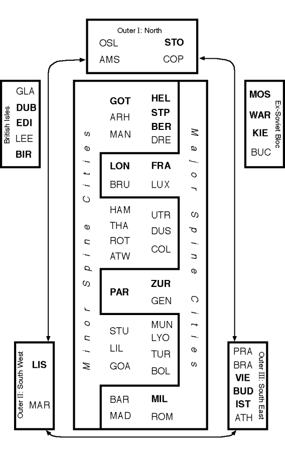
Figure 2: The spatial order of European cities
Cities are allocated by their highest loading.
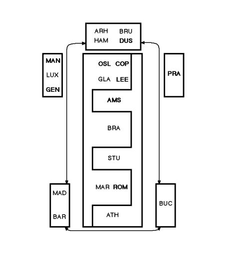
Figure 3: Overlapping cities: secondary locations
Cities with their second highest loading above 0.4. APPENDIXEuropean (service) world cities / evidence of world city formation, listed alphabetically, with abbreviations Amsterdam AMS
Edited and posted on the web on 23rd November 1999; last update 19th January 2000 |
|||||||||||||||||||||||||||||||||||||||||||||||||||||||||||||