GaWC Research Bulletin 133 |
|
|
|
This Research Bulletin has been published in British Medical Bulletin, 69 (1), (2004), 101-114. Please refer to the published version when quoting the paper.
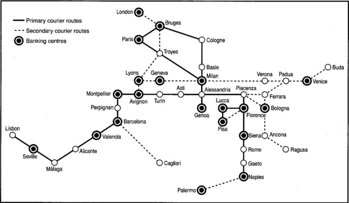
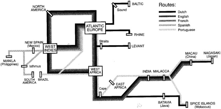
INTRODUCTIONThis chapter looks at the culture of health, disease and mortality from a geographical perspective. However, it does not take the form of a traditional review of the geography of health and the cultural influences of places. That more traditional view involves mapping disease prevalence in various geographical settings and trying to account for observed differences (1,2). In that convention, places are often seen as areas demarcated on the surface of a two-dimensional map, they are simplified and, we could argue, stultified. Comparisons of one place with another, according to a selected number of factors, are then made (the modern technology of GIS encourages such disembodied, displaced comparisons). Such comparisons do not do justice to the full complexity of 'place'(3) and the potential meaning of that for health and illness. All too often, place (the meaning and consequences of a place) is reduced to space (its physical location); moreover, any dimension of time and change is usually excluded so as to be denied importance. The result is a static and limited understanding of the geography of health. In contrast, the aim of this chapter is to take a broad, inclusive worldwide and long-term geographical view and then consider some of the implications of this for health. In this chapter, four maps are presented which represent 'the world' based on power. These are not maps that any medic, social scientist, geographer or historian will immediately recognize. They are maps that represent not people and places, as we might expect, but rather they show networks. Each map thus demarcates flows of power-how the world is run. The text expands upon this and outlines the importance of these channels of power in shaping the health of population in different times and places. The maps are from the work of the geographer Taylora,(4). Interestingly, Taylor makes very few references to health, save for a brief mention of the plague and the bombings and targeting of Sarajevo, Belgrade, New York and Washington. The commentary and interpretations of the maps presented here are my own; hence, I would strongly recommend readers to read the original source and to form their own interpretations. Only by employing a ridiculous degree of reductionism can a broad and inclusive view be presented in just a few pages with a few figures, but as it is just that kind of view which a more cultural geographical approach aims to take, this chapter is an attempt to illustrate how such an approach might begin to be applied to understanding patterns of health. What follows here is an unorthodox view of the human world, its history and its geography. Many people may hold such views, but few of them tend to find work in universities and so their ideas rarely find an audience. Rather than fostering innovative and imaginative thought, universities tend to enforce and refine traditional views of the world. But a chapter in a book such as this is an opportunity to break loose from such traditions, to think laterally. Suppose for a moment that the concept of 'national life expectancy' was meaningless; that international comparisons of disease rates missed the point; that promoting a 'healthy city' was a largely futile endeavour; and that to talk of using analysis that calibrated to the age-sex structure of the 'European standard population' involved not only a people and standard which could not be so defined, but a continent that does, in fact, not exist. And if your view of the human world in general changes substantially, then your view of patterns of health and illness, and what causes them, will also alter. The aim of the chapter is thus to convince the reader not simply that geography is another factor that should be considered when looking at the cultures of health and illness, but that cultures of health and illness are thoroughly imbued with geography, and that indeed they cannot be understood without it. In this sense, the chapter may seem as special pleading for the importance of the domain that keeps me well paid in what I describe as an illusionary temple, and cocooned from the harshness of the world I describe. However, the views that Peter Taylor has are not mainstream in the domain of geography, as it is currently taught and researched worldwide. This is not special pleading for an academic discipline, but for an alternative explanation of how geography influences health and for researchers interested in health to thinking a little wider rather than deeper. BEFORE THE BEGINNINGHere is one possible potted history of the world. The human world we currently live in has only been organized in its current configuration for about 500 years. Before then there had been empires, trading blocks and alliances but these were confined to certain parts of the globe. Often that confinement was deliberate. The Romans did not conquer what is now Scotland because they did not think it was worth conquering (although they did venture in before coming to that decision). The Chinese saw a world outside of their control where there was little worth controlling. Why else did that empire not expand? The world was made up of four continents: the Americas, Africa, Asia and Australasia. On the western peninsula of Asia (what we now call Europe), living conditions, culture or civilization were nothing to write home about were you visiting from the more developed parts of the globe. Few people bothered to visit these West Asians, although the West Asians themselves were becoming increasingly interested in other peoples, not least because they often had spices which could disguise the taste of rotting meat (and meat tends to rot when you have to kill your cattle because you cannot feed them over a harsh winter). It was West Asian merchants returning from one of these trips who brought plague from China to Genoa. Why did the plague spread as it did across what we (and the rest of the world) now acknowledge as Europe? Figure 1 shows the courier routes between major banking and intermediary cities at the time. West Asia was largely organized as a series of city states. Cities became rich through trade. Riches had to be banked and bankers needed to communicate. The primary nodes of this network of flows are highlighted in Figure 1. Important for trade and banking, they became centres for the study of medicine as well as the primary nodes through which epidemics travelled. The human world was organized through interlinked cities-governing, supplying and drawing from their hinterlands. Excess wealth was often turned into grand temples such as cathedrals. Enormous numbers of peasant years are required to finance a cathedral from the tiny profit made at market from each peasant, while huge amounts of potentially excess labour could be absorbed in their construction. The wealth which escaped such reification was further invested and begot more wealth. On the very edge of this network, almost as far as it was possible to get from the other more wealthy cities in the world network, sat a small town called London. Although all the cities shown in Figure 1 still exist, some are now tiny towns and others are 'world cities'. In 1400, had you been speculating to accumulate, you might have thought of buying land in Lucca (Italy) rather than London, but basing your judgment on what you saw at the time would not have served you most profitably. Cities prosper not because of what is in them but because of what flows through them. Their institutions filter a tiny fraction of the resources traded through the firms they host and grow only if such filter feeding is at an adequate level. It is not just goods and services which flow through places, but people too. The extent to which our current and past worlds depend on flows is routinely underestimated. For instance, if it were not for the lifetime migrations of people from birth to final death-place, geographical inequalities in health would appear much reduced within different regions of the world. Healthier people tend to migrate towards healthier areas. In many cases, it is the flow of healthier peoples to particular areas which make the areas appear healthy. Different parts of the human world in general benefit or are harmed by flows of people and resources. It is not places per se which engender or harm health, but what flows through the spaces of places. At particular times, some places are net losers from the aggregate effects of those flows and others net winners. It is not the place that causes this but the particular configuration of flows at the time, which in turn is a product of that place and all other places. A mighty cathedral was built in Milan because of where Milan sat in the place of flows, between Geneva and Venice, Paris and Genoa. Those flows determined the population of Milan and its living standards and how the populations around benefited or suffered. Of course, a city being a net beneficiary of space of flows does not imply all its population will benefit, but it does set a limit on the resources that can be shared either more or less equally. In order to accept that it is flows between places and not places themselves that matter, you may need to change the way you might think of places a little. Peter Taylor argues that the world has been organized through differing configurations of city networks at different times(4). Each configuration is accepted as 'natural' or 'given' at its time, although often it is the relic impression of the last era which prevails. Thus we currently accept a 'metageography' of nation-states and all the artefacts that creates (i.e. there is no such thing as 'national life expectancy' because there is no meaningful nation, life is not organized in that way, there is only life expectancy for a particular group of people identified by place at any one time). Peter Taylor uses examples such as the silliness of having books labelled 'British Birds' to show just how far metageographies can warp clear thinking. It is the winners who get to create the myths. Thus the metageography that there is a fifth continent called Europe only pervades because of what occurred after the 15th century (the fact that it is now called the 15th century is part of that same metageography). In 1579 (Taylor(4), p. 206), an alliance of 58 cities was formed by treaty in what we now call The Netherlands. Amsterdam was at the apex of this alliance which was largely an alliance of merchant families. They did not have a particularly strong desire to build cathedrals or fight wars and thus were able to reinvest their profits from trade more efficiently than before; world capitalism began in earnest (when exactly it began is much debated, but not of huge importance now, save for wondering when it will end). Why and how was this network different? As Figure 2 shows, which also includes the major trade routes that followed the Dutch hegemony, it not only involved reinvesting wealth to beget more wealth, but it spread around the world, and it spread on the seas in order to avoid Islam and the Muslim control of the land trade routes. On a map, the trade routes appear static whereas of course, by definition, trade route maps are maps of flows. The 17th century world metageography was not a geography of superiority. The ocean trade routes were established because there were better things to be had from Africa, the Americas and the rest of Asia than could be found, grown or made 'at home'. It did spread old world diseases to the new world (and vice versa), establish a demand for vastly increased rates of slavery, and, ultimately, changed the way most of the world viewed the modern world. ('Modern' here means since 1579). This mercantile modernity was based on navigation. Its two successors, industrial and consumer modernity, key forms of knowledge lay, respectively in engineering and then advertising. That is, what has mattered most in the last three great periods of time has been getting to places (navigation), making things (engineering) and selling things (advertising). In describing these modernities, Taylor suggests:
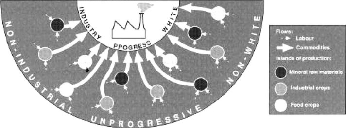
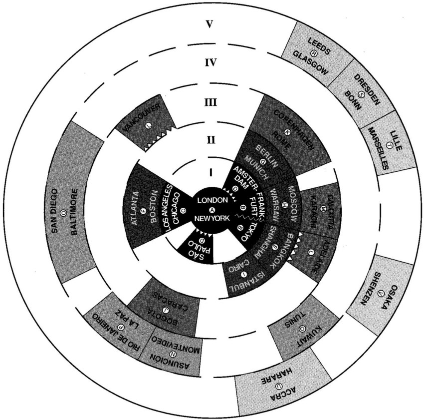
THE CURRENT WORLD METAGEOGRAPHYWe still view the world through 19th century lenses. Figure 3 shows a schematic representation of the world as it existed when the British Empire was at its zenith (it does not mention actual places but you can work out where is where as this is the mode of thinking about world geography you are most likely to have been brought up with). This is not the current metageography, but it takes time for people (and academics) to realise that the world has been reorganized. Taylor suggests that three social sciences were eventually formed under this worldview from the initial intersection of natural science and the humanities. Similarly, it was under industrial modernity that nationalism came to the fore and nation-states were formed. The social sciences each took one aspect of those states to study: its economics, society and politics. That nation-states were not a sensible unit of analysis did not deter these disciplines from studying the 'national economy, 'national civil society' or 'national' (or 'international') politics. Older academic subjects such as anthropology were allowed to wither. World metageographies thus matter because they not only show how the world is (or was) organized, but also determine how knowledge and understanding is organized. The centripetal metageography of industrial modernity dominates medical research. Drug companies see the world as a rich core market and a poor pirating threat. Researchers compare rates of diseases and deaths between nation states without flinching for a second to consider whether Luxembourg is comparable to China or how one iota of what they find, when they compare such odd aggregates, might be meaningful. Researchers (myself included) consider variations in life expectancy within a country(5,6) as if that country's boundaries and subsequent subdivisions collect people together sensibly so that we can infer from those variations the relevant processes at play. Take one example: studies of health in Britain find that life expectancy did not rise for much of the 19th century and inequalities in life expectancy rose rapidly from the late 1970s(7). Almost all studies which look for answers(8) look only within Britain for reasons as to why this occurred and almost all do not mention that Britain was in ascendance as the dominant power of industrial modernity in the former period and in rapid descendance in the latter. All kinds of decisions can be made within a nation-state as to how to distribute resources and these decisions have an impact on health outcomes. Most important, however, is the overall quantity of resources to distribute. Parliamentary democracy and the occasional 20th century liberal government in Britain came at a price that much of the rest of the world had to pay and a price which was not fully extracted until the end of the 19th century. For 70 years from then, the profits from having once run most of the world kept flowing in to Britain (save for a couple of minor hitches involving gold standards and the financing of a war). However by the early 1970s, those profits were running dry, most colonies had won independence and a few Americans and others were taking over the extraction of wealth from the poorest parts of the world. They were just more efficient at it than those who ran the British Empire had been. Faced with rapidly declining resources, the cake within Britain would have to be cut differently if those who decided on the cutting were not to see their living standards fall; and those who decided on the cutting generally resided in London and the Home Counties (called 'home' as that is were those who ran the empire returned home to). In the late 1970s, the decision was made to abandon the towns where industrial modernity had originally been forged. This was expressed as reducing 'regional aid' and opening up markets, but another way of looking at what occurred was that people in the Capital and the Home Counties decided they could no longer afford to allow living standards in the North to rise slowly in parallel but still behind theirs as they would lose out as a result. They decided this in general elections (1979, 1983, 1987) but more importantly in private, not as a conspiracy and not in concert-but as a predictable mass reaction to falling relative resources. Other decisions could have been made, but the total flow of resources was fixed by where British cities found themselves to be in the world city network at that time. And so inequalities in health in Britain rose, to allow the life-chances of better off Britons to continue to rise. Take another example: within some rich nations, health may be found to be, on average, worse when incomes are distributed more unevenly(9). The distributions of incomes within a rich nation depend upon the particular configuration of cities and their hinterlands collected together when the boundaries of those nations were established, often in the 19th century. Incomes tend to be more polarized in larger 'world' cities which contain a few very rich people and many people who serve them, clean their offices and run their subways, while the rich run the world city network and extract their percentage from the flows. Many small European nations do not contain great world cities and thus appear to have lower income inequality and also better health because the boundaries drawn around them (the nation-state boundaries) encompass fewer areas that have been abandoned within them. Areas become abandoned within the shadow of world cities. The relationship first found by plotting nationstates' life expectancy against income inequalities has nothing to do with psycho-social effects, social capital or the like. It is all about the particular 19th century cookie-cutter used to determine the units of analysis. Very different findings would result were, say, the Euro currency nations to be grouped as a single entity and compared to the USA, but again the analysis would be flawed because the units used ignore the way the world works and has worked in the past. Almost every single academic paper (and there are thousands upon thousands) which compares the life-chances of people in different nationstates to other measures of life in those nation-states is flawed in that it assumes the nation-states are sensible entities to compare for what is being studied. The findings of these papers are simply the product of the boundaries used. For instance, were Northern Ireland, Scotland, England and Wales to be compared to Alabama, Canada, California and Mexico, very different results would be found than comparing the UK with North America. Neither of these comparisons would be warranted in how peoples' lives are spatially organized. The comparisons would almost certainly have been made because those were the units for which "the data came". Above all else, nation-states collect statistics (state-istics as Taylor has termed them). The statistics being collected for one set of areas does not make those areas the ones it is sensible to compare. Ironically many of the studies referred to above use the Luxemburg income study (LIS) data (equivalized income distributions for different nation states). In its name the data-series hints at the silliness of its units. THE FUTURE WORLD METAGEOGRAPHYFigure 4 shows the future world metageography-the future already here. This is actually the current world metageography. This figure shows one interpretation of the current geometry of the world city network. This is a geometry calculated from analysing the supposed flows of information between hundreds of cities (using the locations and office status of global firms based in those cities). The method used to draw this map is very similar to that used to create Figure 1 which was also based on flow information. Six hundred years ago, just one firm sent 320,000 dispatches, "17,000 between Florence and Genoa and even 348 between the banking centres of Naples and London at opposite reaches of the network" (Taylor(4), p. 10). Now billions of dispatches are made yearly between firms and their quantity can only be estimated. The matrix of flows produced contains far too many links to be simply projected on a two-dimensional plane. Fuzzy set analysis was used to create the map of the world in Figure 4 which shows one aspect of how the world city network is currently organized. Fuzzy set analysis is simply cluster analysis that allows its units (cities) to belong to more than one cluster to various degrees. What is most shocking about the current/future world metageography is that firmly at its heart is an amalgam of the two most dominant world cities London-New York (LNY). For what matters most, the world is run through LNY. The key headquarters of the most powerful multinational companies in the world are found there. If you don't have an LNY office (or two of course given the 'pond' in the middle) you don't count. That is what the data show, and, in an age where the key knowledge base has moved from being able to navigate the oceans, to engineering on land, to advertising over the air-waves, it is less surprising perhaps that this is where capitalist power now concentratesb. Much else matters as well as advertising (accountancy, banking, insurance, law and management consultancy), but in a consumer age, advertising is key. Around LNY are the leading world cities stretched around LNY 'Main Street'. Only six are shown on the map, but others falling in this category (were there place to name them on the diagram) include: Hong Kong, Paris, Singapore, Tokyo, San Francisco, Zurich, Madrid, Milan, Mexico City and Toronto with Brussels and Barcelona as hybrid members. These are the leading cities that link most strongly to the rest of the world network. Around these cities are Band II and III cities on the map, 'leading regional clusters' of world cities of which an even smaller proportion are shown on the map. Then come Band IV and V cities, 'important cities on the edge' of the world network, of which just a few are shown. All these cities have hinterlands, but also hinterworlds (Taylor(4), p. 101): their connections across the world. Every world city's hinterworld includes every other world city because in every other city there are service firms connected to firms in that city. Much of the world is only very poorly connected to the world city network and the vast majority of the world's population live outside of it. The most striking example that the data produces is that Africa has only has one true authentic world city, Nairobi, and its main function is as a Non-Governmental Organization (NGO) centre (Taylor(4), p. 174), a centre for charity it could be claimed. Given that Africa's only true world city is a city linked by flows of pity and profit from pity, the future prospects for health in that (true) continent are now ominous. What are the implications of this new metageography given that our health is a product of the world system in which we live, as are our belief systems, our academic disciplines and so on? We do not tend to see the next system, or accept it, until it is upon us, and then we accept it as given. Given that, imagine that both my interpretation of Taylor's ideas and his ideas themselves are roughly correct and look a little into the future . . . The world is not getting 'smaller' as communications speed up. It is instead becoming effectively much 'larger' as world population grows and the vast bulk of that population live outside of the key cities with power. Even within those key world cities, the majority of the population live to serve the world city network workers. The people who matter now work for firms whose names when Taylor was counting them (just a few years ago) included Ernst & Young, PricewaterhouseCoopers, Saatchi and Saatchi, Ogilvy, Deutsche Bank, J.P. Morgan, Lloyd's, IBM worldwide and a hundred other multinationals. They include many names you would not recognize (can you name a single major international law firm?). Indeed many have changed their names in the last couple of years. They do not need you to know who they are. They know that they matter. This is no conspiracy. Nobody planned this to happen. Similarly, you know the names of many of the leading world cities, but where is Hamilton, Portland or Port Louis-all amongst the 123 most important cities in the world (these three are not necessarily the most populous cities with those names, but they are most powerful)? Money can abandon firms and places and alight on new opportunities and new places with incredible speed. With money comes health and without it destitution. The implications for health of Taylor's world city analysis are clearest for Africa. That the only 'authentic' world city there is Nairobi and that it is only a world city because it is where the directors of NGOs based 'in the field' prefer to be based is very telling. Money is unlikely to alight on most of that continent in the near and not so near future and without money there is little prospect for rapid improvements in health. In a global age of advertising, the continent with the least resources to consume loses most. Globally, health is likely to appear best where the world city network workers retire (Taylor(4) calls these people with their share options and partnerships "the most successful 'capitalists' in the world today", p. 214). For LNY this includes the South of France, the Home Counties and the South West in England, and the Hamptons, Santa Barbara, Arizona and Hawaii in the USA. When life expectancy, already high, rises further in these places it has almost nothing to do with these places, rather they are simply the areas where the population who creamed a percentage of a percentage of a million deals finally choose to eventually die. They do not choose to die in London or New York, but it is in and through those places, and only a few hundred others like them, that they become wealthy. Before the modern world system began, farming was the key world knowledge skill. Now a knowledge of farming practices is a good indicator, globally, that your health will be poor. Knowing how to grow your own food is no longer good for your health. Given that good health depends largely and most immediately on access to good food it is worth reflecting on how we got to this position. Skills lose their currency. Very few people know now how to navigate using the stars, sun and clocks- mention these skills at most job interviews and they will not be valued (you will not get the job). When thousands of steam engines had to be built and run, for everything from pumping water to powering ships, engineering was valuable. Mass production and computer aided design make making things as a living dispensable or easily replaceable. One day knowing how to advertise a product, interpret consumer law in different settings, move money between cities, advise companies on downsizing, underwrite losses or produce a set of accounts to please share holders will also become defunct skills. But that day is some way away and so it is the places and particular enclaves within world cities where these people live, and where they retire to, which will be the most healthy places for most of the coming century. CONCLUSIONSThink global, don't become obsessed with the local. The world is getting bigger, however for you it is probably becoming smaller. The vast majority of the world's population will never see LNY. If you could afford to buy this book, or have access to a library that stocks it, you can almost certainly afford to see London and New York and have probably visited at least one-half of this 'Main Street'. Next time you are there think: how on earth can these grubby streets and worn out looking people be from where the world is run and run it? On a second or third visit the sky scrapers are less impressive, the suits and coffee bars not so new, the hustle and bustle becomes more humdrum. The world's main street is housed in two 19th century aging cities with sewer systems and transport problems to match. They have the power but not the pizzazz. When you meet the accountants, actuaries, advertisers, bankers, financiers, insurance underwriters, lawyers and management consultants they turn out to have little idea of the nature of the world they are living in or even the purposes of their work, they are simply doing their jobs and paying to train their children to do the same, saving for a second or third home and fretting about what an awful job their cleaner does. Millions of children die a year through diarrhoea as a consequence of poverty brought on through the actions of people who would find it hard to fix (or even locate) their own cold water tank, let alone grow their own food. If the world does work the way in which Peter Taylor describes, very few people actually realise this; a great deal of current research including radical research on health is largely oblivious to such thinking. Nationstates are waning in power. Established as protection mechanisms to attempt to hold back the power of mercantile modernity they now offer little protection under consumer modernity. Be ahead of the rest, stop using the nation-state, national statistics and international comparisons now; instead study the health within and between cities and how each city's fortunes depend on many others. What are the connections between the health of the population of most of the world who live outside the hinterland and hinterworlds of the world cities and their tenuous connections to that key network through smaller urban centres? Within the world cities how do the knowledge workers maintain their ignorance of the lives of others in their city (and vice versa)? Could it be that flows of money, as much as microbes, matter? NOTES* Department of Geography, University of Sheffield, Sheffield, UK a. On a personal note, as a 19-year-old undergraduate, I thought I heard Peter Taylor in a lecture explain that as universities were allowed to exist to be the temples of the truth for the current way the world was run then almost everything done in them sought to further that system and the beliefs the system was built upon(10). Scientific rationality was simply a language which had been found to be useful in justifying the current way in which we (unfairly) organized our lives. Ideas you are presented with when you are 19 tend to stick better than those at 29 or 39, as they have fewer with which to compete. Similarly, for someone who does not read enough, one book-Taylor(4)-can have an undue influence! Peter Taylor may have actually said something else in that lecture, since lectures are not a particularly efficient means of conveying ideas, however, I have found viewing universities as illusionary temples makes them much easier places in which to work (especially if you find reading and writing, which trend to be the stock in trade of most academics, difficult). b. That knowledge of how to advertise is the key world skill is no joke (you may be thinking 'what has the world come to?'). Had you told someone in 1500 that ability to sail with the stars and watches would soon be the skills to have, or in 1700 than knowing how to use steam to move a piston might be useful, they may well have not taken you seriously too. REFERENCES1 Dorling D, Fairbairn D. Mapping Ways of Representing the World. London: Longman, 1997 2 Shaw M, Dorling D, Mitchell R. Health, Place and Society. Harlow: Pearson Education, 2002 3 Tunstall H, Shaw M, Dorling D. Glossary: places and health. J Epidemiol Commun Health 2004; 58: 6-10 4 Taylor PJ. World City Network, A Global Urban Analysis. London: Routledge, 2004 5 Dorling D. Death in Britain: How Local Mortality Rates have Changed: 1950s-1990s. Report published by the Joseph Rowntree Foundation, 1997 6 Shaw M, Dorling D, Gordon D, Davey Smith G. The Widening Gap: Health Inequalities and Policy in Britain. Bristol: The Policy Press, 2001 7 Charlton J, Murphy M (eds) The Health of Adult Britain 1841-1994, vol. 1. London: Stationery Office, 1997 8 Gordon D, Davey Smith G, Dorling D, Shaw M. Inequalities in Health: the Evidence. Bristol: The Policy Press, 1999 9 Wilkinson RG. Unhealthy Societies: The Afflictions of Inequality. Routledge: London, 1996 10 Taylor PJ. Personal communication: Political Geography Course, Lecture notes, Department of Geography, University of Newcastle upon Tyne, 1987 11 Taylor PJ. Metageographical moments: a geohistorical interpretation of embedded statism and globalization. In: Tetreault MA et al (eds) Rethinking Political Global Economy, Emerging Issues, Unfolding Odysseys. London: Routledge, 2003 Figure 1: Inter-city courier services in late medieval Europe (circa 14th to 15th centuries). Flows not places matter.
Source: Taylor(4), p. 10, Figure 1.2. Figure 2: The topological metageography of mercantile modernity (mid 17th century).
Source: Taylor(4), p. 182, Figure 8.1. Figure 3: The centripetal metageography of industrial modernity (late 19th century).
Source: Taylor(4), p. 183, Figure 8.2. Figure 4: Urban arenas from fuzzy set analysis (early 21st century).
Source: Taylor(4), p. 168, Figure 7.4. Edited and posted on the web on 3rd February 2004
Note: This Research Bulletin has been published in British Medical Bulletin, 69 (1), (2004), 101-114
|
||