GaWC Annual Lecture 2004 |
|
|
One useful question to ask in academic life, I've always found, is: what's new and different? We have the mega-city, which we owe particularly to Janice Perlman, but goes back quite a long way – about 2400 years in fact. Thanks to the GaWC group, we have a welcome revival of the term world city –which we can date back to 1910, if not before. The term global city seems to go back to Saskia Sassen, in 1991 – but we can argue, and I’ll argue, that it’s essentially a derivation from John Friedmann, who put a particular spin on the older world city concept. GaWC really put these two together, as the Globalized World City. And then there’s its derivation the Global City Region, which we owe to Allan Scott - and in turn its derivation, the Global Mega-City Region, of which more later on. But the mega-city phenomenon of course isn’t new at all: the Greeks clearly regarded their Megalopolis as a very big place, at least potentially, but perhaps that was the earliest known case of urban boosterism. It was founded around 370 B.C. by Epaminondas of Thebes, and its wall reached about 9 kilometres round; but it never seems to have got any bigger than about 40,000 people at its zenith (Chandler and Fox 1974, 80). Even Athens, which we know seemed dangerously large to the people of the ancient world, was preposterously small by our standards. In 432 B.C., at the beginning of the Peloponnesian war, when its population probably reached its maximum, the entire Athenian polis - city and surrounding countryside - had between 215,000 and 300,000 people, of whom citizens numbered 35‑45,000. Rome of course was much more serious: a kind of rehearsal or trailer for what cities would later become. It was, simply, the first giant city in world history. Precisely how big is a matter for huge guesstimates: they vary wildly, but the great majority, for various dates over four or five centuries, come in the range from three quarters of a million to around one and a quarter million, most of them close to one million. You can take your pick: the fact is that Rome was very big, bigger by far than any city before, and probably bigger than any that would follow it for the next seven hundred years. That huge size positively forced its administrators to devise complex systems of international food supplies, to grapple successfully with long-distance delivery of water and with complex systems of waste disposal, even to formulate rules of urban traffic management. WORLD CITIES AND GLOBAL CITIESBut we’re clearly concerned with more than mere size this afternoon – hence those other elusive terms, world city and global city. World cities, too, are not exactly a new phenomenon. Patrick Geddes already recognized them and defined them, as long ago as 1910, in a book that has become a classic of the planning literature: Cities in Evolution (Geddes 1915). But, as with a lot that Geddes wrote, the meaning there isn’t absolutely clear. In fact, apart from the chapter title, he never once tells us what he means, except that he’s clearly talking about conurbations – a word he did invent – in countries other than Great Britain. About fifty years later, I was a bit more specific. In a book called The World Cities (Hall 1966), I defined them in terms of multiple roles. I wrote then: There are certain great cities in which a quite disproportionate part of the world's most important business is conducted. In 1915 the pioneer thinker and writer on city and regional planning, Patrick Geddes, christened them ”the world cities”. This book is about their growth and problems. So what was special about them? In executive summary: world cities were centres of political power, both national and international, and of the organizations related to government; centres of national and international trade, acting as entrepôts for their countries and sometimes for neighbouring countries also; hence, centres of banking, insurance and related financial services; centres of advanced professional activity of all kind, in medicine, in law, in the higher learning, and the application of scientific knowledge to technology; centres of information gathering and diffusion, through publishing and the mass media; centres of conspicuous consumption, both of luxury goods for the minority and mass-produced goods for the multitude; centres of arts, culture and entertainment, and of the ancillary activities that catered for them. And, I argued, these kinds of activities tended to grow in importance; so, in the twentieth century, the world cities went from strength to strength: even as they shed some kinds of activity, from routine manufacturing to routine paper-processing, so they took on new functions and added to existing ones (Hall 1966, 1984). This definition, I would argue, still applies nearly forty years later. But it now needs a bit of crisping up, because of the phenomenon of globalization and its impact on the urban system, coupled with what can be called the informationalization of the economy, the progressive shift of advanced economies from goods production to information handling, whereby the great majority of the workforce no longer deal with material outputs. Twenty years ago John Friedmann was the first to suggest that this was resulting in a global hierarchy, in which London, New York and Tokyo are "global financial articulations", Miami, Los Angeles, Frankfurt, Amsterdam and Singapore and "multinational articulations", and Paris, Zürich, Madrid, Mexico City, São Paulo, Seoul and Sydney are "important national articulations", all forming a "network". In 1991 Saskia Sassen made this a central theme of her book on Global Cities. Manuel Castells has characterized this as the fundamental economic shift of the present era, as momentous as the shift from an agrarian to an industrial economy in the eighteenth and nineteenth centuries. Now the interesting point is that all this is not new either. The process of tertiarization of the economy was already recognized half a century ago (Clark 1940); by the 1980s, 30-40 per cent of the workforce in advanced countries were engaged in informational industries. For London, David Kynaston's excellent history gives a comprehensive view of the nineteenth-century global trading city. Thirty foreign banks were already established in London before 1914, 19 between the two world wars, another 87 down to 1969. Then the pace accelerated: 183 in the 1970s, 115 in the first half of the 1980s; in all, between 1914 and the end of 1985 the number of foreign banks in the City grew more than fourteen-fold, from 30 to 434. Both London and New York now had more foreign than domestic banks (Thrift 1987, 210; King 1990, 89-90, 113; Moran 1991, 4; Coakley 1992, 57-61; Kynaston 1994, 1995, passim). In the 1980s some commentators argued persuasively that, despite all this, such activities still depend fundamentally on production (Gershuny and Miles 1983; Cohen and Zysman 1987); but evidently, as the combined effect of globalization and informationalization, the important point is that the production of advanced business or producer services becomes increasingly disarticulated from that of production. As Saskia Sassen has put it: The spatial dispersion of production, including its internationalization, has contributed to the growth of centralized service nodes for the management and regulation of the new space economy ... To a considerable extent, the weight of economic activity over the last fifteen years has shifted from production places such as Detroit and Manchester, to centers of finance and highly specialized services (Sassen 1991, 325). Thus, as production disperses worldwide, services increasingly concentrate into a relatively few trading cities, both the well-known "global cities" and a second rung of about twenty cities immediately below these, which we can distinguish as "sub-global". These cities are centres for financial services (banking, insurance) and headquarters of major production companies; most are also seats of the major world-power governments (King 1990, Sassen 1991). They attract specialized business services like commercial law and accountancy, advertising and public relations services and legal services, which are themselves increasingly globalized, and related to controlling headquarters locations. In turn this clustering attracts business tourism and real estate functions; business tourism allies with leisure tourism because both are in part drawn to these cities because of their cultural reputations, with effects on the transportation, communication, personal services and entertainment-cultural sectors. There is intense competition between cities both at a given level in the hierarchy and also between levels in the hierarchy; but also a great deal of historic inertia. To sum up, I can go back to GaWC. Let me quote from the important 1999 paper by Beaverstock, Taylor and Smith.
Looking back over these thirty years of work, they identify four major approaches which have led to 'standardised' rankings of major cities. The first phase sought to identify the strategic domination of certain world cities in the world-system by analysing and ranking the locational preferences and roles of multinational corporation (MNC) headquarters in the 'developed' world (Hall, 1966; Hymer, 1972; Heenan, 1977). Then, building upon Hall (1966) and especially Hymer (1972), a second approach centred upon the decision-making corporate activities and power of MNCs, in the context of the new (spatial) international division of labour discovered in the late 1970s (Frobel, et al.,1980). This approach, which includes such key works as Cohen (1981), Friedmann and Wolff (1982), Friedmann (1986), Glickman (1987), Feagin and Smith (1987) and to some degree Knox (1995a-b) and Thrift (1989), has enriched the 'theoretical' approach taken to world city studies, but has also acted as a major catalyst for work in the 1990s. A third approach has firmly associated the cities within the urban hierarchy with their propensity to engage with the internationalisation, concentration and intensity of producer services in the world economy. The key work here is undoubtedly that of Saskia Sassen, in The Global City (1991) and Cities in a World Economy (1994). Finally, a fourth approach identifies major cities and their relative positions through rankings of international financial centres. The pioneering work here has come from Howard Reed (1981). These four approaches, they suggest, are perhaps not quite as distinct as they may seem: thus Sassen's producer services includes Read's financial services. Table 1: Cited Major Cities
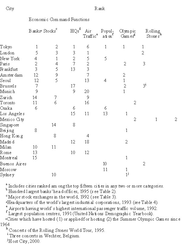
1 Limited to the top five cities identified in the global urban hierarchy. Source: Beaverstock, Smith and Taylor 1999, Table 1. A key argument of the Loughborough group is that many of the approaches – even the classics, such as Friedmann (1986, 1995) and Sassen (1991, 1994) – concentrate simply on measuring data on global city attributes, while ignoring the critical importance of understanding the mutual relationships between individual members of a system of cities. Perhaps the best recent example of the attribute approach comes from John Short and colleagues at the University of Syracuse, who present comparative data in order to try to disprove much of what they say is the conventional wisdom about so-called global cities - in particular, the primacy of London and New York. Their data (ranked in Table 2) show that in 1995, in terms of the head office location of the largest banks ranked by assets, the score was Tokyo 16, Paris 11, Frankfurt 6, New York 5, and London 5; in terms of headquarters of the world's largest industrial corporations in 1993, the scores were Tokyo 17, New York 6, London 5, and Chicago, Seoul and Osaka 4 each; in terms of Stock Exchange market valuation, the order in 1992 was New York $3888 bn., Tokyo $2321 bn., London $933 bn., Paris $328 bn., and Frankfurt $321 bn. ; in terms of headquarters of the top 50 foreign banks [in terms of assets in 1994] in the USA, the score was Tokyo 14, Paris 6, Osaka 4, Toronto 3, and London 3. Finally, in terms of international air passengers [in 1992] the numbers were London 59,003, Paris 32,369, Frankfurt 23,711, Hong Kong 22,061, New York 19,609, and Tokyo 19,022 (Short et al 1996, 703-8). Table 2: World City Dataa
Source: Short et al 1996, Table 9. These data are very suggestive, but – as the Loughborough group argue - they tell us nothing about the mutual relationships among the members of this system of cities; we have to infer for instance that, because of a concentration of high-level service activities such as international banks, a city is exceptionally well-connected. To some degree, as Beaverstock and Taylor point out, this emphasis is simply due to the abundance of data on attributes and the relative paucity of data on relationships. There are some exceptions: for instance, air traffic data and telecommunications traffic data. But they suffer from lack of differentiation: air traffic figures for Miami, for instance, are distorted by the huge tourist traffic into and out of Florida – and similarly, though perhaps to a lesser degree, with the figures for London as compared with other major cities, presented in Figs. 1-2. However, this raises yet another complication. High-level global cities can be distinguished by a high degree of concentration of four particular clusters of advanced services: command and control functions (government, international agencies, headquarters of major private corporations); financial and business services (ranging from commercial services like accountancy, law and advertising to public relations, management consultancy and the design professions of architecture, civil engineering, fashion and interior design); tourism of both the leisure and business varieties; and cultural and creative industries, including the live performing arts, museums and galleries, and the print and electronic media (newspapers, magazines, books, film, television, radio). These activities prove to be highly symbiotic: thus business services attract business travellers who may also use cultural facilities; urban tourism and culture are mutually supportive). The fact that London is the first international airport system in traffic terms reflects the fact that it is simultaneously a major business centre, and a major cultural centre and a major tourist centre, and all these are synergistic; likewise with competitor cities like Paris, Amsterdam or Rome (Llewelyn Davies 1996; Association of London Government 1997). There is an additional problem here, created by the existence of national boundaries. Despite major advances in European integration in the last decade – the Single European market, Economic and Monetary Union, the Schengen agreement for the effective abolition of borders – Europe is still a system of separate nation states, with separate languages and cultures, in a way that the United States and Canada and Australia (and other continental-scale nations, like China, Brazil and Argentina) are not. Very evidently, this combination of state power, language and culture creates protected urban systems in a way that more open and uniform systems do not. In Europe, small capital cities like Brussels, Copenhagen, Stockholm, Helsinki, Vienna and Lisbon have a command over their national territories – in terms of governmental systems, legal systems, and the mass media – that is quite disproportionate to their size. And this combines in some cases with traditional specialisms (such as Zürich in banking, Milan in fashion, or Paris in art) that create a non-hierarchical urban pattern (Hall 1995). Some cities in other continents also display niche specialisms (e.g. Boston and San Francisco for financial services, and Los Angeles for media), but because no other continent has so many small nation states with long cultural histories, no other presents quite this degree of non-hierarchical richness. And, of course, international boundaries completely distort comparisons of international air traffic: it is no accident that European airports figure so prominently in Fig. 1. This poses a basic question: as Beaverstock et al (1997, 2) comment: on most indicators London is the most important city in Europe, but how in relational terms is it connected to other European cities? and does that place it at the apex of a hierarchy, or is the relationship more complex and non-hierarchical? Attribute data alone will not supply the answer to these questions. Nor even, perhaps, will relational data: Fig. 2 is very suggestive, with its particularly strong linkages between London, New York and Tokyo but with regional or continental linkages between each of these cities and other cities in the same part of the world, but how far these relationships are symmetrical, suggesting equality between the centres, or how far asymmetrical, suggesting a hierarchy, cannot be read from the map. In order to overcome this basic problem, the Loughborough group have used three different ways of measuring relationships between cities: first, content analysis of leading business newspapers; second, interviewing practitioners; and third, detailed analysis of producer services, in particular the structure of branch offices of large producer services such as accountancy or law (Beaverstock et al 1999, 2-4). The third approach is the one they have increasingly employed. Though it does not record actual transactions, of course, it does lay bare firms’ spatial strategies. The overseas branches constitute a city’s outward relations, allowing us to infer the geographical relationship between any given pair of cities. Table x shows some results. THE ESDP: AN ALTERNATIVE APPROACHThere’s yet another way of classifying cities, though. You can find it in the European Union’s European Spatial Development Perspective, finalized in 1999. It’s essentially geographical in character, contrasting a Central Capital Region (an enlarged version of which has been latterly called the Pentagon), with its dense cluster of high-level cities closely networked through air, high-speed-train and telecommunications links (London, Paris, Frankfurt, Luxembourg, Brussels, Amsterdam), and the "gateway" or "regional capital" cities in the more peripheral European regions, each dominating a large but less-densely-populated territory (Dublin, Edinburgh, Copenhagen, Stockholm, Helsinki, Berlin, Vienna, Rome, Madrid, Lisbon plus the eastern European capitals of Ljubljana, Budapest, Prague, Warsaw and Tallinn). Here, we find an interesting degree of competition between a higher-order city that appears to control such a wide sector of the European space, and next-order cities controlling parts of that space (as, for instance, Copenhagen versus Stockholm and Helsinki; Berlin versus Vienna; Vienna versus Prague and Budapest; Madrid versus Lisbon). Additionally, in one or two instances, this critical Euro-regional role is divided between a "political" and a "commercial" capital (Rome and Milan; Madrid and Barcelona). These intermediate-size gateway cities have proved relatively dynamic in the 1970s and 1980s. They invariably act as regional airport hubs, with a range of long-distance destinations (Copenhagen, Madrid) and as the hubs of regional high-speed-train systems (Madrid, Rome); they have a wide variety of global service functions, especially where they dominate linguistic regions (as Madrid for Latin America). With expansion of the EU eastwards, the eastern gateway cities (Berlin, Vienna) promise to play new roles in their respective areas, returning to the roles they played before 1914. However, policy does not appear to have played much of a direct role in this development; it is a function of European geography and its relation to the wider global economy. And it must not be forgotten that the political geography is quite different: the old German and Austro-Hungarian empires have been dismembered, and the 1919 Versailles settlement remains, fortified by linguistic and cultural differentiation. Smaller cities seem to have experienced some advantages when they are clustered so as to constitute a wider economic area sharing labour markets and specialised services. The outstanding examples are the Greater South East region outside London and the fringes of Randstad Holland, which form global mega-city-regions –a term to which I promise to return! But many other parts of Europe have developed corridors of intense urbanisation along major transport spines, as in the Rhine Valley above Frankfurt, the Rhone Valley below Lyon, or the Emilia-Romagna region of Italy. In a few cases (as in South East England) planning policy has played a conscious role in this; elsewhere, again, it seems to have been a spontaneous evolution. But there is now a general agreement that such a form, which can combine small mixed-use urban developments clustered along strong public transport spines, represents perhaps the most sustainable form of urban development; and some national planning strategies are beginning to adopt it, for instance in the UK. In the future they will be joined by similar cities in central Europe, such as Wrocław, Poznań, Plzeň and Szeged. Many more isolated medium-sized towns, outside these major trans-European corridors but located on national movement corridors connecting larger cities, have shown remarkable dynamism. Examples include Nottingham and Bristol, Hannover and Munich, Grenoble and Toulouse, Naples and Ravenna, Zaragoza and Valencia. The key seems to be first that they are in "Sunbelt" rural regions that are themselves prosperous, either through efficient agricultural production, or (more commonly) because these cities themselves have become the main centres for advanced service employment. Public sector spending policies have played a role here, by concentrating such functions as higher education and hospitals in these places. But the sources of growth are more subtle than this, and such places show remarkable variations in fortune, depending on local socio-cultural factors that may go back for centuries - as, for instance, between northern and southern Italy. How does one try to summarise this mass of partial and sometimes contradictory data? Some kinds of urban area, it seems, are unambiguously growing through in-migration: First, the hinterlands of the major cities, mainly in Northern and Central Europe, that are benefiting from the exodus from these cities into wider “mega-city regions” - as around London, Copenhagen and Randstad Holland; possibly this trend has weakened since 1980 with the trend to reurbanisation, though rapid growth has continued in the fringe areas. Second, medium-sized and smaller metropolitan areas in less-urbanised "sunbelt" zones with medium-sized and smaller cities, particularly in the southern UK, southern France, Portugal and central and northern Italy. Third, a few selected larger urban centres and their immediate hinterlands in the less-developed, less-densely-populated regions of rural out-migration, particularly Scandinavia, Mediterranean Europe, Ireland and some eastern European countries. This tends to reflect the magnetism of such cities at the stage of development these regions have reached, and also government policies in eastern Europe. It also reflects that there are relatively few such large city regions in these parts of Europe which can act as foci for in-migration. These trends reflect underlying economic realities. Globalisation and the shift to the informational economy give special value to large cities as centres for efficient face-to-face information exchange. They are the locations of the major hub airports and the high-speed train stations; they also are hubs for commuter traffic. But they also experience some economic disadvantages: high rents, congestion, pollution, the costs of attracting middle- and junior-level staff. So certain activities ("back offices", R & D) tend to migrate outwards: to corridors leading to the airports, to suburban train stations, to country towns in the surrounding ring. Meanwhile, medium-sized cities ("provincial capitals") in "sunbelt" rural regions (Bristol, Hannover, Bordeaux, Oporto, Seville, Bologna) are growing through strong concentrations of public services (higher education, health services), retailing and tourism. Some of these also act as centres of high-technology manufacturing, and/or have attracted longer-distance office decentralisation. Some similar-level cities in older industrial regions (Dortmund, Leeds) have seen a similar growth, though others have been less successful, especially if they are peripheral either nationally or in a European sense. Finally, there are many cases of growth at the next level of the hierarchy: the "county town", or medium-sized administrative-service centre of a rural region, of which hundreds of European examples exist. These centres have grown as local service centres; they often offer a high level of environment (and some, like Freiburg, are outstanding examples); they are attractive both to migration and inward investment. The European Spatial Development Perspective adopts a central principle of polycentricity, allied to concentrated deconcentration: a principle long ago adopted in Dutch spatial planning, which aims to disperse economic development from congested urban regions, but to reconcentrate it in urban centres in the less developed regions, thus benefiting both kinds of region. However, it does so at the largest possible geographical scale. The aim is not so much to redistribute some fixed amount of activity in a kind of zero-sum-game; it is to encourage a significantly higher level of growth in less-developed regions and cities, some of which will be older industrial cities in need of restructuring, but a much larger number of which will be cities in the less densely-populated, less-developed fringe regions of western, southern, northern and eastern Europe. Here, it is necessary to realise that the central word, polycentric, needs to be carefully defined: it has a different significance at different spatial scales and in different geographical contexts. At the global level, polycentric refers to the development of alternative global centres of power. Presently, there are a very few cities worldwide that are universally regarded as global control-and-command centres, located in the most advanced economies: London appears in all lists, Paris appears on some. Importantly, however, Europe has a number of "sub-global" cities, performing some global functions in specialised fields: Rome (culture), Milan (fashion), Frankfurt and Zürich (banking), Brussels, Luxembourg, Paris, Rome and Geneva (supernational government agencies) (Hall 1993, Hall 1995b, 1995c, Hall 1996). Within a specifically European context, therefore, one meaning of a polycentric policy is to divert some activities away from "global" cities like London (and perhaps Paris) to "sub-global" centres like Brussels, Frankfurt or Milan. But there is also a very important spatial dimension: while some of these cities are found in the Central Capitals region (Brussels, Amsterdam, Frankfurt, Luxembourg), a much larger number are "gateway" national political or commercial capitals outside the Centre Capitals region: they include Helsinki, Stockholm, Copenhagen, Berlin, Vienna, Rome/Milan, Madrid/Barcelona, Lisbon and Dublin. They serve broad but sometimes thinly-populated territories such as the Iberian peninsula, Scandinavia and east central Europe. Because they are national capitals serving distinct linguistic groups, they invariably have a level of service functions larger than would be expected on grounds of size alone; they tend to be national airport and rail hubs, and the main centres for national cultural institutions and national media. A major issue here is whether it will be either necessary or desirable to concentrate decentralised activity into a limited number of "regional capitals", each commanding a significant sector of the European territory - Copenhagen, Berlin, Rome, Madrid - or whether it would be preferable to diffuse down to the level of the national capital cities, including the smaller national capitals. Essentially, how far should Madrid be regarded as the dominant gateway for south west Europe, or should it share this role with Lisbon, Bilbao, Barcelona and Seville? And likewise with Copenhagen vis-à-vis Stockholm, Oslo and Helsinki. This could be particularly important in eastern Europe, where Berlin and Vienna may develop important roles for their hinterlands reflecting past geographies, but where also there is a real need to reassert the service roles of the different national capitals and selected provincial capitals (Gdánsk, Kraków, Plzeň, Szeged). At a finer geographical scale, however, polycentricity can refer to the outward diffusion from either of these levels of city to smaller cities within their urban fields or spheres of influence. We have already noticed that such a process has occurred on a wide scale around London, which is now the centre of a “mega-city-region” of some 30-40 centres within a 150-km. radius, while (for different historical reasons) Paris and Berlin in contrast have much more weakly-developed urban systems. At the next level, cities like Stockholm, Copenhagen and Milan also show widespread outward diffusion while other cities do not. East European cities, in particular, have had relatively little impact through decentralisation on their surrounding regions, though this may change in the future. In general, at this scale a policy of "deconcentrated concentration" would suggest adopting the principle fairly widely, but adapting it to the specific development stages and problems of each city and region. Specifically, the general principle should be to guide decentralised growth, wherever possible, on to a few selected development corridors along strong public transport links, including high-speed "regional metros" such as those under construction around Stockholm and Copenhagen, and planned for London, or even along true high-speed lines such as London-Ashford, Amsterdam-Antwerp or Berlin-Magdeburg. These would not of course be corridors of continuous urbanisation, but rather clusters of urban developments, at intervals, around train stations and key motorway interchanges that offer exceptionally good accessibility. Some of these sites could be at considerable distances, up to 150 kilometres, from the central metropolitan city. In the more remote rural regions, far from the global and sub-global centres, the pursuit of polycentricity must have yet another dimension: to build up the potential of both "regional capitals" in the 200,000-500,000 population range (Bristol, Bordeaux, Hannover, Ravenna, Zaragoza, Gdańsk, Lublin, Brno), including some smaller national capitals (Vilnius, Ljubljana) and smaller "county towns" in the 50,000-200,000 range. The main agents will be enhanced accessibility both by road and (most importantly) high-speed train, coupled with investment in key higher-level service infrastructure (health, education); the systematic enhancement of environmental quality, to make as many as possible of these cities "model sustainable cities"; and finally the competitive marketing of such cities as places for inward investment and relocation. Again, but on a smaller scale, the growth of such centres could be accompanied by a limited degree of deconcentration to even smaller rural towns within easy reach. So we begin to see a potential contradiction in meeting ESDP objectives: dispersal from large cities into “mega-city-regions”, which may be occurring around several different kinds of city – Central Cities (London-South East England, Amsterdam-Delta Metropolis, Rhine-Ruhr, Rhine-Main), Gateway Cities (Copenhagen-Ørestad, Barcelona-Catalonia) and Provincial Capitals (Stockholm-Mälardalen, Seville-Andalucia) may produce a more polycentric system at the local level but a less polycentric system at a higher, European level. This impinges particularly on the countries that will enter the EU in May 2004, and on their urban systems. Most are small, some very small, and are very strongly monocentric in their urban structures: their capital cities dominate them both demographically and economically. Enlargement is if anything likely to accentuate and exaggerate this quality, as leading economic sectors grow in the “gateway” capital cities and as long-delayed economic adjustments take place, leading to rural-urban migration on the pattern characteristic of western European countries in the years immediately after the Treaty of Rome. The pattern is likely to parallel what happened in Spain and Portugal and Ireland and Greece when they entered the Community between 1973 and 1986. Only perhaps in Poland, by far the largest of the accession countries, is this likely to be balanced by growth of larger regional cities such as Gdańsk and Kraków. But in none of these countries, as yet, does there appear to be a phenomenon of local polycentricity (the formation of “mega city regions”) which is characteristic of the most densely populated North West European heartland. The nearest candidates for the future may be Central Bohemia, the Katowice-Kraków corridor and the international Vienna-Bratislava-Győr region. These tendencies are so far latent and incipient. But, given the emerging importance of the mega-city-region in terms of economic clustering and its potential competitive advantage, it will be vitally important throughout Europe that we are able to measure polycentricity, and its accompanying transport systems, at more than one spatial scale. It is a complex strategy, and its further elaboration will be an important central part of the new programme for the European Spatial Programme Observatories Network in which we are now so actively involved, as well as the related Interreg IIIB and IIIC programmes which will play a vital complementary role in analysing the phenomenon in the key regions of the Union. As a basis for understanding the outcomes of these processes, it’s useful to look at a map from an EU publication. It shows the network of major European cities and the key transport network linkages between them. It also shows the notorious “Blue Banana” or dorsale from the 1989 DATAR study (Brunet 1989), the point of which has been endlessly debated by urbanists ever since; the most likely was that it was purely political, intended to show that Paris was being bypassed by the main communication lines of Europe. MOVING INFORMATIONBut there is a point here: even in a world where much information is now conveyed through high technology, to the degree that high technology and information technology tend almost to become conflated, information is still communicated in two entirely different ways: by electronic transfer, but also by direct face-to-face communication. Face-to-face communication, as recognized long ago by the American economist Robert Murray Haig (Haig 1926), encourages agglomeration in the global cities, because of their historically strong concentrations of information-gathering and informational-exchanging activities and their position as nodes for national and international movement, especially by air and now also high-speed train (Hall 1991, 1992a, 1992b, 1993). And this is fortified by the remarkable recent growth of the arts, culture and entertainment sector, where - for instance - employment grew by 20 per cent in London during the 1980s (London Planning Advisory Committee 1991), with further indirect impacts on associated personal services including hotels, restaurants, bars and associated facilities. For this group, too, clusters within urban cores and is subject to considerable locational inertia; but this can be modified by revitalization projects like London's South Bank and Barbican, or the Grands Projets in Paris. However, it was never feasible to operate an informational economy simply on the basis of dense agglomeration; even at the end of the Middle Ages, Florentine bankers were engaged in dense networks of activity between the major cities of Europe, and into the Far East, all conducted by couriers rushing all over the then globe. And, as global activity increased under capitalism, so transport networks multiplied, connecting these dense face-to-face agglomerations, in the form of railway systems and steamship lines backed up first by letter post, then by the telegraph from the 1830s, then by the telephone from the 1870s. During the nineteenth century, the growth of global cities like London, New York and Tokyo was supported by their position as centres of national rail networks and of international steamship lines (though the latter might operate through subsidiary ports connected by railways, such as Liverpool and then Southampton for London, Le Havre for Paris, Hamburg for Berlin, or Yokohama for Tokyo). Then, to some extent in the interwar period but overwhelmingly after it, air travel supplanted trains and ships for all intercontinental business travel and a substantial proportion of local inter-city travel over a certain threshold [typically about 300 kilometres]. Since this revolution, which was more or less complete by the end of the 1950s, the technology of air travel has remained remarkably stable, though increases in size and range of aircraft have had a significant impact in eliminating the need for intermediate stops on long-haul flights, with some notable urban impacts - particularly over the Pacific, the world's largest ocean (O'Connor 1995). One consequence, associated also with the dominance of a few major airlines and the increasing tendency to mergers and strategic alliances between them, is that this traffic is increasingly concentrated on to a relatively few major hub airports, all in the largest cities, which offer the biggest range of direct nonstop flights and also the most convenient and frequent interlining facilities. Recent studies of the interconnectivity of cities by air suggest that London is top, followed by Paris, New York and Tokyo (Smith and Timberlake 1995, 298; Cattan 1995, 304-308). The really new element, constituting a further transport revolution of profound significance, has been the arrival of the high-speed train, first in Japan in 1964 [and thus a fourth Kondratieff technology], then in Europe in the 1970s and 1980s. Experience shows that effectively it competes with air transportation in the range up to about 500 kilometres, and may effectively supplant it for much shorter-distance traffic between major urban centres, particularly if these centres are disposed in axial or corridor fashion [as is the case for instance on the Tokaido corridor in Japan between Tokyo and Osaka, or in Europe between Paris, Lyon and Marseille, or between Hamburg, Hannover, Frankfurt, Stuttgart and Munich, or more recently between London, Paris and Brussels). The significance of the trains is not merely that they compete effectively, but that they are likely to alter the delicate geographical balance within metropolitan areas: with the exception of some services deliberately designed to interconnect with longer-distance air routes [as for instance through Paris-Charles de Gaulle], they essentially connect traditional central business districts, and thus powerfully help to correct any tendency on the part of business to migrate from these centres to suburban locations close to the airports - a trend long observed in the United States, but now becoming evident in Europe also, in developments around London Heathrow, Paris Charles de Gaulle, Amsterdam Schiphol or Stockholm Arlanda. We tend to think of telecommunications as substituting for personal travel and face-to-face meetings – a myth encouraged by the telecoms companies, of course. But the reality is that they are also complimentary. Data from France show that over a long period, the curves for telecommunications traffic and personal travel have risen almost precisely in parallel (Graham and Marvin 1995, 262); I have no doubt that the evidence from every other country would be identical. If you need further evidence, just look at the growth of international business air travel, at the growth of the major international hotel chains, or indeed the convention business. Again, apart from developments in some major resort areas such as Florida or Queensland's Gold Coast, these convention centres tend to be located in the hearts of the major cities, next to existing concentrations of business hotels and restaurants and associated nightlife. They form a very significant part of the phenomenon of business tourism, one of the fastest-growing sectors in the global cities today, and one that is highly synergistic with the other growth sectors. A major question for Europe is whether the Single Market and the impacts of the Maastricht treaty will progressively assist the higher-order cities at the expense of the lower national-order ones. Related to this is the question whether cities with a distinct function within the European Union - Brussels, Luxembourg and Frankfurt - will progressively assert their role at the expense of London and, to some extent, Paris. This is an open question; but it should be noticed that the Euro-cities form a tight inner circle surrounded by a wider group of national capitals - London, Paris and Amsterdam - forming what the EC's Europe 2000+ report calls the Central Capitals Region -all within convenient radius for face-to-face contact by air and, increasingly, by high-speed train [which, on present plans, should connect all of them by approximately 2010]. So it seems certain that they will constitute an effective central core of the European urban system. In turn they will be connected by regular and frequent air services to a number of key regional cities which effectively form an outer ring some 500-700 kilometres distant: Copenhagen, Berlin, Vienna, Zurich, Milan, Madrid, Dublin, Edinburgh. These places will also be connected by high-speed train to cities within their own 500-kilometre radii: Milan with Turin and Venice and Bologna, Berlin with Hanover and Hamburg and Leipzig, Madrid with Seville and Barcelona - and will thus form the points of articulation between the European and the regional schemes of exchange. A key element in this scheme is “Europe’s New Trunk Line” – a conscious borrowing from the Japanese Shinkansen, and more prosaically known to Eurocrats as PBKAL, Paris-Brussels-Köln-Amsterdam-London. Comprising two high-speed train networks – Eurostar and Thalys – by 2007 it should be complete: a network of new high-speed lines taking dense flows of passengers at speeds of 300 km./hr., 186 m.p.h. – between the principal cities of North West Europe. Our own CTRL, the first part of which opened three months ago, is an integral part of it, but it also includes new and upgraded lines open or under construction in Belgium, the Netherlands and Germany. It has already effectively taken virtually all traffic away from air in the Paris-Brussels sector with a journey time of only 1 hour 25 minutes, and some two-thirds of combined London-Paris traffic with a time of 2 hours 35 minutes, to be cut to 2 hours 20 minutes in 2007. One major question is how effectively the stations on the new system will integrate with longer-distance air travel, thus forming feeders to and from inter-continental services. Some airports – Paris Charles de Gaulle, Amsterdam Schiphol, Frankfurt – have planned ahead, and are models to the rest of the world. Amsterdam probably wins the prize for the fastest and easiest air-to-rail transfer, but Frankfurt deserves a special prize for the spectacular quality of its new high-speed-train station. Already, spatial development strategies at a European level are beginning consciously to develop strategies based on these key land transportation corridors, as clearly shown in the strategy for the North West Metropolitan Area, which shows urban clusters at key interchanges on the new network. Rather confusingly, with their typical population range of one to four million, the national capitals and commercial capitals associated with these airport and train hubs overlap in size with the major provincial capitals of the larger European nation states: thus Manchester and Birmingham, Lyon and Marseille, Hannover and Stuttgart, Florence and Naples, Seville and Valencia. These places typically serve as administrative and higher-level service centres for mixed urban-rural regions, most though not all of them prosperous, and they have shown considerable dynamism even while they too have lost traditional manufacturing and goods-handling functions. These cities do not as a rule compete in any substantial respect, either nationally or still less internationally, with the higher-order cities, though they may occasionally occupy special market niches. The important but subtle distinction is whether a city offers any significant presence or significant challenge at the global level; in this respect Brussels and Frankfurt and Milan, like Chicago, Los Angeles and Osaka, can be said to act as global contenders in specially defined spheres, though not of course across the board, and so can best be defined as sub-global; Manchester and Munich and Copenhagen, Minneapolis and Denver, Sendai and Kumamoto, to take examples more or less at random, can not. MOVING OUT: THE TREND TO DECONCENTRATIONIn order to further understand the dynamics of the European urban system, we also need to understand what is happening within these mega-urban-regions. We all know the answer, I suppose: in the last forty years deconcentration, first of residences and latterly also of employment, has become a universal phenomenon, not merely in Europe but in virtually all the world's metropolitan areas: once unique to the Anglo-American-Australian group of cities, it has now become characteristic of the whole of western Europe and of Japan. And in the largest of these areas, the global and the sub-global cities, this process of deconcentration has become extremely complex, extending over very wide areas of territory in a dynamic process which results in a highly polycentric metropolitan system: the polycentric global mega-city region, emerging reality of 21st-century urbanization. Broadly, one can say that down to about 1950 even the world's major cities had a much simpler pattern of living and working: there was a mass of white-collar employment in the centre, a wide [and increasing] ring of commuter suburbs outside, interspersed by industrial, port and warehouse areas with their own much more localized residential areas immediately next to them; the entire complex dependent primarily on public transport, plus walking and cycling for the most local journeys. Then, already in American cities before World War II but in European cities only on any scale from the 1960s, further residential suburbanization occurred outside the limits of effective public transport systems, and therefore dependent on the private car. At the same time employment began to decentralize, first routine assembly manufacturing in search of spacious premises close to highway systems; second R&D and associated small-batch high-technology production, which moved to high-amenity locations, often close to airports for international access; and third back offices performing routine processing applications for national headquarters firms, which moved to local suburban centres with ample local supplies of clerical labour; all accompanied of course by local service employment in shops, schools and other public and private services, dispersed across the region. And finally, in the late 1980s and 1990s, there was evidence from some American cities - not merely New York, which I've already mentioned, but also San Francisco and of course Los Angeles - of a more general exodus of even headquarters offices to suburban locations, apparently impelled in some cases by high local taxes. The result in extreme cases, represented by London and New York and Los Angeles, is a pattern of extremely long-distance deconcentration stretching up to 150 kilometres from the centre, with local concentrations of employment surrounded by overlapping commuter fields, and served mainly by the private car. The precise spatial details vary from country to country according to culture and planning regime: in the United States, lower-density and less regulated with "Edge Cities" or "New Downtowns" on greenfield sites, exclusively accessed by the private car; in Europe, medium-density, regulated through green belts and other constraints, and centred on medium-sized country market towns or planned new towns (Garreau 1991). And the process has gone much further in some large metropolitan areas [for instance, London] than in others [for instance, Paris, where suburbanization has almost entirely been captured in the large new cities resulting from the 1965 regional master plan]. However, the general outward trend, both for population and employment, is universal. An interesting consequence has been accelerated growth in and around smaller country towns in the wider metropolitan orbit, especially those adjacent to major national highway and/or railway lines [that is, in the "transport-rich, city rich" sectors in the Lösch central place model]. Thus, in some cases there is a distinct tendency to linear corridor growth, as in the so-called M4 corridor west of London or the E4 Arlanda airport corridor north of Stockholm, both based on a combination of high-technology industry and back-office functions. Some regional plans, including the Stockholm plan of 1966 and the Paris plan a year earlier, made a deliberate attempt to guide development into such corridors; but the same phenomenon has occurred spontaneously in other cases, such as the I-405 "Aerospace Alley" in Los Angeles and Orange counties, or the "Dulles Airport Corridor" in the Virginia suburbs of Washington DC. And some observers purport to see the development of even more extensive growth corridors connecting cities along highways and high-speed train lines, such as the "Dorsale" or "Blue Banana" of western Europe connecting London, Brussels, Frankfurt, Zurich and Milan (Hall et al 1973; Brunet 1989). East of London, the UK government's Thames Gateway proposal is a discontinuous series of urban developments following the planned new high-speed line from London to the Channel Tunnel: the first attempt to create such a corridor on a conscious basis (G.B. Thames Gateway Task Force 1994). A vigorous debate has raged in the academic prints concerning the consequences of this process of deconcentration for commuter travel and thus for sustainable urbanization. There isn’t time to discuss it here, and besides this isn’t the place. But there are some morals we can draw. First, grouping people and jobs close together in reasonably self-contained units, as Howard proposed and the British tried to do in their new towns after World War II, is a reasonable objective - particularly if, at a micro scale, homes and jobs were intermixed. Howard's intuitively-based size for his garden cities - 32,000 - was not bad in terms of transport sustainability, despite the fact that it was produced at a time when the motor car was a novelty, but it proved difficult to combine it with an adequate range of jobs and services. That of course was because everyone had forgotten the original Social City diagram. Second, it was also right to try to keep the new British towns outside the London commuting orbit, even if some commuted and more might later do so; you could keep the new towns quite self-contained on a day-to-day basis [and the evidence is that some at least of the commuters found local jobs after a while], while providing good access to London for less frequent business contacts, which have become more and more significant with the growth of service industry jobs and the decentralisation of back offices into the new towns. Finally, putting homes and jobs in patterns of high linear density along strong public transport spines, as the Swedes did in their Stockholm satellites of the 1950s and 1960s, is also right - especially if, again, some jobs were provided close to homes, as the Swedes tried to do, and if wide - in fact increasingly wide - green wedges are thus created between these corridors of urbanization. All represent partial answers, by no means mutually exclusive: but hardly any place seems to have combined them in a package. This can of course be assisted and guided by conscious planning. In 1898 Ebenezer Howard proposed clusters of garden cities, linked by rapid transit systems, as an answer to the problems of slum housing in London. And, beginning with Letchworth Garden City in 1903 and Welwyn Garden City in 1920, he actually launched the construction of such a cluster, which was completed by the designation of two of the first new towns – Stevenage and Hatfield – in the late 1940s. It is linked, interestingly, by the A1(M) motorway and the high-speed East Coast Main Line. A few years after those new towns were started, the 1952 General Plan for Stockholm linked the existing city to new satellite towns based on a new transit system, the Tunnelbana. Unlike the British new towns, they were not to be completely self-contained: they were based on the one-third principle, whereby one third of the economically-active residents commuted out – mainly to work in the city centre, hence the elaborate T-Centralen interchange station ringed by shops and offices - and one-third of the workforce commuted in, hence the Tunnelbana. The new satellites were likewise grouped around local shops and offices, and the Tunnelbana station was at the core of each; pyramids of density ensured that most residents lived within walking distance. We should remember that the Mark One London new towns, and the Scandinavian satellites, were devised for a much poorer society, in which the majority of people would be renters of social housing provided by large monolithic agencies; they had no choice. Nor did they have much choice in transport, for car ownership levels were extremely low and expected to remain so. There is clear evidence that all the calculations of the Stockholm planners were upset by the rapid rise of car ownership in the 1960s. But this is coupled with the fact that Stockholm is a relatively small and compact city of only about a million and a half people. Even if people could be persuaded to continue to use the Tunnelbana for the radial journeys to the city centre, it made little sense for orbital journeys when they could get into their comfortable Volvos and use the ring road the planners had provided to get freight around the city. This suggests that the structure has to be more encouraging to public transport use, perhaps by eliminating as far as possible the need or desire for non-radial journeys. Even so, like the British new towns, the Stockholm satellites still work better than equivalent settlement forms in similar locations (Cervero 1995b, 1995c). All this is interestingly supported by a lot of academic research on sustainable urban development, by geographers and planners like Susan Owens, Michael Breheny and David Banister. They agree in supporting clusters of compact settlements of up to about 200,000 people, with medium-high densities (25 dwellings or 40 people per hectare) and locally mixed land uses, arrayed along strong public transport corridors which range from bus routes up to heavy rail systems. There is an uncanny similarity between the diagrams in Breheny and Rookwood’s celebrated 1993 paper on the subject, and those drawn in complete independence, the same year, by the California architect-planner Peter Calthorpe, showing what he calls Transit Oriented Developments or TODs: walking-scale suburban developments around public transport stops, clustering some job and service opportunities at the nodes, and with high-density single-family housing built in traditional terraces with street parking (Kelbaugh 1989; Calthorpe 1993). Colin Ward and I tried to develop these ideas in actual regional contexts in our 1998 book Sociable Cities, with three clusters of settlements along public transport corridors some 70-80 miles from London. And there is a very strong resemblance of both to what Scandinavian planners were attempting in the 1950s and 1960s – or with Ebenezer Howard’s Social Cities of 1898! In practice, the American experience is less impressive so far. The New Urbanists have achieved very good neo-traditional designs at the local scale, as we can see in the Washington DC suburban development at Kentlands by Andres Duany and Elizabeth Plater-Zyberk, or the west coast example at Mountain View in Silicon Valley from Peter Calthorpe. But at a larger scale their schemes have foundered through incomplete integration, especially with transport. The Crossings at Mountain View is at least integrated with the Valley Transit light rail system, but Kentlands is not integrated at all with the Washington DC Metro. And the most ambitious early scheme, Peter Calthorpe’s Laguna West outside Sacramento, is not integrated with that city’s light rail system; not, in the near future, is it likely to be. At the same time, developing transport technology is offering ever greater potential for clustering on an even larger spatial scale. Scandinavia has pioneered the concept of the regional metro. A development of the German S-Bahn and the Paris RER, but on an even larger scale, it allows fast frequent metro services to serve an entire mega-city region as far as 100 kilometres from the central city. The new Copenhagen system, which links two formerly separate commuter systems in two different countries via the new Øresund crossing, even integrates completely with the Copenhagen airport, major hub of the SAS system. Thameslink 2000, when it is eventually completed, will be the first such regional metro for London. But even greater potential is offered by new high-speed lines. Domestic services on the new Channel Tunnel Rail Link can allow a cluster of urban development in East Kent, as we proposed in Sociable Cities. Already, the French have planned their new TGV station at Lille as the centre of an ambitious commercial development, intended to serve the entire urban region. This is a city centre development. But two even more significant developments can be seen in Japan and the Netherlands. Shin Yokohama (New Yokohama) station on the Shinkansen, some 20 miles outside Tokyo, was in the middle of rice fields when it opened forty years ago, and was seen as a commercial failure. But now it is the centre of a remarkable Japanese style edge city, clustered around the station and its interchange with the Yokohama Metro system. In the Netherlands, Dutch policy now encourages the development of a similar edge city around the Amsterdam South Station at the southern edge of the city, which integrates every form of rail transit – European high-speed, inter-city, local; suburban, metro and tram - plus the adjacent Schiphol airport. The UK government have of course embraced a number of these ideas in their Sustainable Communities strategy of 2003, which is based on three discontinuous development corridors: one north from London into the South Midlands, another up the M11 via Stansted airport to Cambridge, a third down the lower Thames with an outlier in Ashford. It is a breathtakingly refreshing piece of large-scale strategic thinking, with proposals over the next twenty years for no less than 200,000 new homes over and above previously-planned levels. The most ambitious is a discontinuous corridor of clustered urban development stretching for some 70 miles from the edge of London, through Milton Keynes and Northampton, as far as Corby in Northamptonshire, more than 80 miles from London. But in some ways the most interesting is still Thames Gateway, a 50-mile corridor on both sides of the Lower Thames from East London to the river estuary, and consciously developed along the line of CTRL, with intermediate stations at Stratford in East London and Ebbsfleet in Thamesside Kent, as well as at Ashford serving a separate development there. The strategy here is still the one developed in 1995, through the corridor has been subsequently extended on the Essex side; the 2003 revision has specific targets for both employment and housing at key locations, particularly around the stations. Some of the most advanced plans are for large-scale housing on the Greenwich Peninsula as well as a major leisure development around the ill-starred Millennium Dome, served by the giant North Greenwich transport interchange; the commercial and retail and high-density housing development around the new Stratford station, which could also serve a successful 2012 Olympic bid; and the remarkable masterplan based on the dramatic improvement of accessibility to Kent Thamesside, for the development of an old chalk quarry, between the Bluewater retail park and the new Ebbsfleet train station, including both housing and commercial development along the line of a new express busway system. In some ways, Thames Gateway is the archetype of the new 21st-century urban form in its most highly planned variant: a discontinuous corridor, part of Europe’s largest Mega-City-Region, arrayed along a strong international and domestic multimodal transport corridor, with new developments clustered along it at key nodal points. We need more such bold strategic experiments in the other corridors identified in the government’s new strategy. But what we also need now, above all, is more research on how, precisely, these new urban phenomena actually work. Fortunately, with the aid of European research money and with international research collaboration, we have already begun to make real advances with the Interreg IIC Corridesign study and now the Interreg IIIB Polynet study, on which ICS and Loughborough are collaborating together with no less than seven other universities and research institutes in North West Europe. We hope and we believe that in two years’ time we will have begun to find the key to the mystery: how exactly, through combinations of electronic and face-to-face communication, people and companies and institutions interact to exchange information in the new knowledge economy based on production of advanced services. And, most important question of all, what role does the old principle of agglomeration play in the new world of the World Wide Web and increasingly sophisticated high-speed networking? We can be sure that agglomeration and clustering still matter. How far they matter, and over what geographical scales, is the question we must now address. It’s a wonderful agenda for the next decade of GaWC research – and I’m pleased to announce that these will be central questions for our new POLYNET research, on which ICS and Loughborough will be collaborating over the next two years. Wish us luck, and wait for the results with bated breath. NOTE* Institute of Community Studies, London Edited and posted on the web on 7th January 2004 |
|||||||||||||||||||||||||||||||||||||||||||||||||||||||||