From Megalopolis to Megapolitan: Framework for Planning Trans-Metropolitan Development in the US
Funded by: The Lincoln Foundation
Grant Holder: Rob Lang (Metropolitan Institute at Virginia Tech)
Researcher: To be appointed at the Metropolitan Institute at Virginia Tech
[Results and Media Coverage]
Abstract
According to European Spatial Planners (Faludi 2002), the primary urban unit for integration into the global economy is a trans-metropolitan area, or what Gottman (1964) refers to as a Megalopolis. Interestingly, Europeans find that the US has several of these places while the European Union may have but one. In an ironic twist, Americans do not even recognize what may be one of the nation's key assets in global competition. The main reason is that no official trans-metropolitan geography exists. This proposal seeks to establish this geography and offer a framework for planning trans-metropolitan development. The study will explore ways to identify and measure US Megapolitan areas, which are defined here as functionally and spatially connected trans-metropolitan area clusters.
The research proposed here would build on prior attempts to understand trans-metropolitan clusters by adding new data and theory to the literature, and by developing a precise and defensible definition of Megapolitan Areas. The current work related to Megapolitan development relies mostly on an analysis of spatial connectivity between places, which can be shown with such tools as satellite imagery. This research focuses on the space of places, or the physical distribution of the built environment. But there is also a space of flows, or sets of connections that link places via business networks, or even air travel (Castells 1996). According to theory, the most complete geographic understanding emerges by looking at both the place and flow of space (Taylor 2004). The proposed study on Megapolitan growth would address both realities.
The Megapolitan project would use data developed by Peter Taylor and Robert Lang (2004) on the US world city network to add a new flow dimension to the existing place-only analysis of trans-metropolitan clusters. Taylor and Lang also have new data that shows the flow of business travelers in the US, which is another way to demonstrate connectivity. In addition to analyzing flow, the Megapolitan research effort would refine and supplement place-only models by European Spatial Planners and by Barnett et al (2004). The refinement would draw in data on the geography of Micropolitan areas by Lang and Dhavale (2004), regional analysis of sprawl patterns by Lang (2002), and projections of real estate development trends by Nelson (2004). The deliverable is a report that includes definitions, maps, population figures, and demographic trends for Megapolitan areas.
The ultimate goal of this research is for the US Census Bureau to formally adopt a Megapolitan designation. In doing so, Census would confer legitimacy onto Megapolitan areas that would help these places start planning. Federal aid in areas such as transportation could be tied to Megapolitan planning much the way it has recently been linked to metropolitan planning. The Intermodal Surface Transit Efficiency Act of 1991 required regions to form Metropolitan Planning Organizations (MPOs) in order to receive federal money for transportation projects. In a similar vein, new super MPOs could result from future legislation that directs Megapolitan Areas to plan on a vast new scale.
Project Description
Primary Objective
The primary objective of the Megapolitan research effort is to move the US toward large-scale urban planning. The Europeans have developed and are refining models of trans-metropolitan growth that stretches over international borders within the European Union (EU). They see these efforts as an essential step toward integrating their union and as way to better plan European urban areas so that they can compete in the global economy (Faludi 2002).
Researchers in Europe argue that large-scale urbanized areas are the primary geographic unit for integration into the world economy. They are concerned that the EU currently has only one well-defined global integration zonethe area inside the so-called Pentagon that runs from London, to Hamburg, to Munich, to Milan, to Paris, and back to London (Schon 2000). By contrast, the US may have at least four such zonesone runs along the East Coast from Boston to Atlanta; there is a Midwestern triangle between Detroit, Minneapolis, and St Louis; a Texas triangle between Houston, Dallas and San Antonio; and a West Coast zone that links Seattle to San Diego (Mehlbye 2000).
While the Europeans believe that US urban areas are better structured for global integration than EU cities, American government agencies and planning organizations do not recognize this advantage. Partly this results from the lack of a standard trans-metropolitan definition. This project will help set that standard by providing an empirical basis for an official Megapolitan label by the US Census Bureau. It will also advance the state of knowledge in understanding the process of large-scale urbanization.
The Megapolitan areas would comprise the US Census' largest geographic unit. Their official designation could spur a discussion of what types of planning needs to be done on this scale. In Europe, spatial planning is now being used to guide new infrastructure investment such as high-speed trains between networked city centers. The US should do the same. The Interstate Highway routes that run through contiguous urbanization, such as I-95 from Boston, MA to Washington, DC; or I-85 from Raleigh, NC to Birmingham, AL; need unified planning. A new census Megapolitan definition would legitimize large-scale transportation planning and trigger similar efforts in such areas as economic development and environmental impact.
While this objective of US Census recognition may be ambitious, it is also doable. The recent creation of Micropolitan areas after several years of review and debate shows that the bureau is willing to revise its standards and accurately capture emerging metropolitan development patterns.
Theory, Data and Methods
Why the name Megapolitan?
The name Megapolitan plays off of the Megalopolis concept developed by Jean Gottman (1964). Megalopolis was the first description of a trans-metropolitan region. The term captured the public mind, and led to people sometimes referring to the Northeastern US as Boswashor the combined metropolitan areas of Boston, New York, Philadelphia, Baltimore and Washington. To this day, the term Megalopolis still resonates; it generates nearly 100,000 citations on a Google search. But the Census never adopted the Megapolitan concept formally because it did not have an empirical basis much beyond the fact that urban development along the US Eastern Seaboard ran together. Also, in the mid 1960s, there were no other parts area that fully shared this character of contiguous urbanization. In other words, why use a term that applies to only one case?
Today, many more places qualify as a Megalopolis, or in the proposed terminology, Megapolitan. In fact, the recently devised Micropolitan areas have made urban growth seem even more connected than ever. Micropolitan areas, which are smaller metropolitan areas that have central cities with populations of 10,000 to 50,000 residents, serve as filler between metropolitan areas and link up vast areas of space. There are so many Micropolitan areas in the East, and they spread so widely, that a trip down I-95 from Maine to Miami now passes through just five counties that are non-metropolitan (Lang and Dhavale 2004). Additionally, for the first time less than half the land area of the Lower-48 US states lies in non-metropolitan counties (Lang and Dhavale 2004). Like the closing of the American Frontier in the 1890 Census, the country seems to have reached another settlement watershed. The time is right for the emergence of Megapolitan areas that reflect this change.
Interestingly, the name Megapolitan was under consideration during the Census' last review of metropolitan area standards just prior to the 2000 Census (Federal Register 1999). As part of a redefinition proposal to categorize metropolitan areas by size, the catch all metropolitan category was to be scrapped. In its place, were to be Megapolitan areas, where the central cities had more than one million residents, and Macropolitan areas, in regions with central cities ranging from 50,000 to 999,999 residents. Although this hierarchical system was not adopted, it shows the Census to be experimental and cognizant of the fact that American development patterns vary by scale. The fact that the Census already picked Megapolitan as the label for the biggest US cities bodes well for the term now being applied to the largest-scale urbanization.
Theory and Data
Several previous research efforts sought to identify Megapolitan development, including Gottman's (1964) original work on the Northeastern US Megalopolis, and a recent geographic analysis by Barnett et al (2004) to document what are termed Super Cities. In 2003, the US Census Bureau created a new trans-metropolitan designation that it calls a Combined Statistical Area. Census remains interested in developing new models of clustered metropolitan development. In Europe, researchers also identified similar trans-metro urbanization as an analytic basis for spatial planning by the European Union (Faludi 2002).
The work to date on trans-metropolitan development has used mainly spatial analysis. But this proposed research will also draw on theories that consider how flow can define space. At a broad level, the Megapolitan research operationalizes Manual Castells' (1996) concept of a space of flows in network society. Castells contrasts traditional concern for spaces of places (e.g., cities) with contemporary transnational movements of people, commodities, and especially, information, which he calls spaces of flows. This space of flows is found at a range of different geographical scales up to and including the global scale. Cities within networks and in Megapolitan clusters are the critical nodes of the space of flows. In this research, the large-scale spaces of flows are described through measures of inter-city relations.
The Census, the main creator of the nation's geographic statistics, does not provide data on flows between American cities. Thus new data must be generated. But all data collection has to be directed by a clear specification of the process to be measured. This research uses a methodology pioneered by the Peter Taylor (2004) and developed for American cities by Taylor and Lang (2004).
Taylor's network model can show how linked a city is to another on the basis of business contacts as measured through the branch offices of major firms in key areas of the producer service economy. The Taylor (2004) model works as follows:
Firms from six key producer service sectors are investigated: accounting, advertising, banking/finance, insurance, law, and management consulting. Global service firms were identified as those with offices in 15 or more cities including at least one city in each of North America, Western Europe, and Pacific Asia. In other words these firms clearly have a global strategy for the service provisioning of their clients. One hundred such firms were identified: 18 in accounting, 15 in advertising, 23 in banking/finance, 11 in insurance, 16 in law, and 17 in management consulting. Offices of these firms were described across 315 cities worldwide
. The cities were defined broadly as city-regions or metropolitan areas but in practice the service offices considered were largely concentrated in the central city, especially their downtowns. Using information (mainly gathered from firms' websites) each firm's distribution of offices was determined and each city coded in terms of its importance, or service value in the firm's office network. Two types of information about individual city offices were employed: the size of the office as a service provided (e.g., the number of partners based in a law firm's office), and the extra-locational functions of a city office (e.g., a regional headquarters).
Taylor and Lang (2004) found that most US cities maintain dense local connections. Midwestern cities such as Chicago, Minneapolis, and Detroit had very strong business links, indicating a Megapolitan economy. This tight connectivity also holds true for Texas cities such as Dallas and Houston. The Taylor model would be applied to the Megapolitan concept by showing how business networks draw regions of the country closer together. The method can also help determine the placement of marginal cases. For example, is Richmond, VA more integrated into the Northeast Megapolitan area from Boston to Washington, or the Southern Megapolitan from Raleigh, NC to Birmingham, AL? The Taylor network-city method can answer at least one part of that question. Preliminary analysis hints that it is part of the Northeast.
In contrast to flow data, which has to be gathered by researchers, place data are collected by federal bureaus such as the Census. There are also well-developed theories of place, including some specific to the US. In his work on the cultural geography of the US, Wilbur Zelinsky (1973) divides the nation into distinct zones based on migratory patterns, environmental conditions, and vernacular customs. Zelinsky's cultural geography lines up with some consistency to the areas that Barnett et al (2004) define as Super Cities. Again, Zelinsky can help with marginal cases. Is Pittsburgh in the Midwest or the East? Culturally, according to Zelinsky, it is a Midwestern city despite being located in the Eastern state of Pennsylvania.
Lang (2002) shows that urbanization patterns vary considerably and produce distinct regional metropolitan built forms. These differences also mostly follow Zelinsky's divisions of the US. The Southern metropolitan areas that reach from Raleigh, NC southwest to Birmingham, AL are generally built at lower densities than the US average, and are continuing to spread further out. By contrast, Florida's urbanized places are mainly denser than average and are either maintaining their relatively higher densities, or getting denser. Lang argues that environment and history play a big role in producing different urban forms in places such as Texas, the Midwest, the West, the Northeast, and Florida. Thus Florida may be technically in the South, but according to Lang, Florida is not of the South spatially. Lang also notes that metropolitan areas that share a common urban form and built environment, often face similar challenges and it therefore makes sense for them to form a common geographic unit.
Cultural geography can also help with naming the regions. The specific Megapolitan labels may seem like a trivial concern, but it is one of the most important aspects of this research. That is because Megapolitan areas need an organic basis in community if they are to be accepted, which the right name can convey. Cultural geographers look at place names and map their range. Some of these names extend over areas that are roughly contiguous to the Super Cities found by Barnett et al. For example, the Southern Super City identified by Barnett's group roughly corresponds to what is locally referred to as the Piedmont. Thus the name Barnett's Southern Super City could be the Piedmont Megapolitan Area.
Methods and Mapping
From the theory and data a place-flow model of Megapolitan geography will be devised and tested through an iterative process that involves vetting the findings with experts in both the US and Europe who are working along similar lines. Construction of the place-flow model will begin with an already defined geographythe Census Bureau's new Combined Statistical Areas (CSAs). CSAs were created in 2003 and are the first trans-metropolitan category that Census has ever identified.
A CSA is composed of multiple metropolitan and Micropolitan areas, which are in turn made up of counties. Along with the change to CSAs, Census shifted from a binary definition of metropolitan versus non-metropolitan to a new core-based system that places metropolitan areas in two size classesmetropolitan or Micropolitandepending on the size of their central city. Micropolitan areas can combine with metropolitan areas to form large-scale CSAs. Note that geography is not the sole determinant for the connection. Not all contiguous metros and micros are part of CSAs; there must be an economic, or a functional, relationship. Together, these two types of statistical areas identify counties with economic and geographic ties to each other. Map 1 below shows current CSAs.
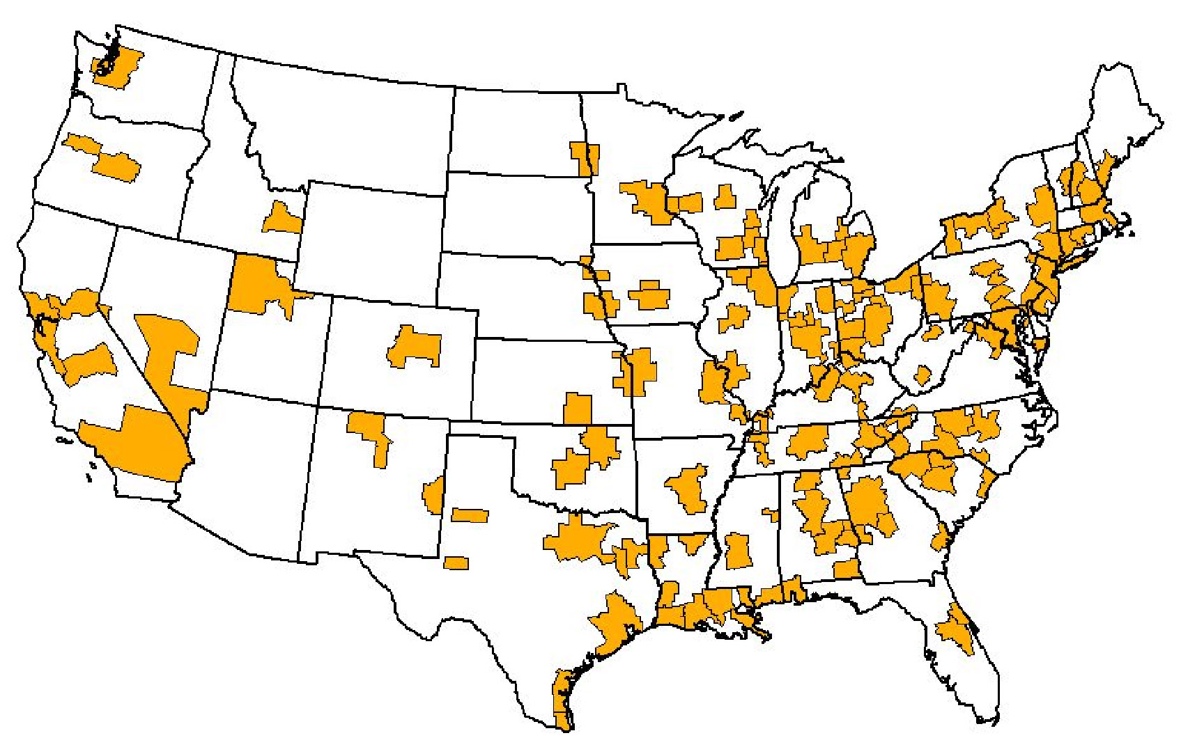
Map 1. US Combined Statistical Areas, 2004
Using the CSAs as a base map, the next step is to add in the Super City map developed by Barnett et al. CSAs have the benefit of being designated with specific and quantifiable criteria. As with CSAs, counties will form the basic building blocks for Megapolitan areas. Census works off counties and so must a new Megapolitan definition if it is to be adopted. To the extent that is possible, the counties will be lined up with the Super City map. Using counties as the basic geographic unit allows Nelson's (2004) work on real estate development trends over the next 30 years to be drawn into the analysis. This will permit the final Megapolitan map to project where new metropolitan connections may occur spatially.
After comparing the elements of current built environments and growth projections, the analysis would next turn to the flow components. Taylor and Lang (2004) developed a virtual geography of US city networks that shows how relationships would translate in space were the density of networks between cities is used to determine their proximity to one another. Imagine a map where New York is fixed and all other major US cities float in location depending on how networked they are to New York. Experimental attempts to map this New York-centric network produced something akin to the famous New Yorker magazine cover
entitled A View of the World from Ninth Avenue by Saul Steinberg. In this illustration, the world west of the Hudson River, starting with New Jersey, is compressed and insignificant. In the Taylor and Lang virtual geography, this world remains compressed, only some of the elements have shifted around. Now in the space that Steinberg shows New Jersey would sit Washington, DC, which has jumped over Philadelphia to land just over the Hudson from New York. This same analysis can be done with other cities such as Chicago, which pulls most Midwestern cities into its immediate orbit. The Taylor and Lang virtual geography will be further developed based on newly acquired business travel data. The picture that emerges from this analysis will be a world where clusters of cities link up in virtual space, which reveals the flow relationships underling actual geographic space.
The Megapolitan base maps will follow the space and flow modeling. At this point, counties will be assigned to specific Megapolitan areas. The next step will be to determine Megapolitan population as of the 2000 Census. Megapolitan growth over the past decade will also be calculated. This will provide some important baseline figures. For the first time it can be known how many people live in Megapolitan areas, what percentage of the country this constitutes, and what rate of growth is occurring in these places. Additionally, the data can answer such basic questions as: which is the biggest Megapolitan area; which is gaining the fastest; what are the demographics of these places; and are they richer and more diverse than the rest of the US? All of the above questions can be addressed even in this preliminary research once the counties to be included in each Megapolitan area are fixed.
After the preliminary definitions are confirmed, and basic demographics are compiled, the findings will be shared with the Barnett group at the University of Pennsylvania and European spatial planning researchers for feedback. Following revisions from these meetings, the Megapolitan areas will be named, mapped, counted and described. A report will be written and presented at the six-month meeting of the Lincoln Fellows. The final deliverable will be an article that is submitted to an academic journal.
Primary Audience
The primary audience for the proposed Megapolitan research is the US Census Bureau, which through the Office of Management and Budget, authorizes standards for defining places. The Census seeks input on ways to better label and measure the nation's dynamic urban development. It was, for example, quite responsive to research that showed the value in redefining much of non-metropolitan America as Micropolitan. The Census needs a technically sound definition to work from as the basis for new labels, which the proposed research will help produce.
There are also secondary audiences that the Megapolitan research would reach. These include elected officials and policy makers whose localities would be impacted by a Megapolitan designation. Given the vast scale of Megapolitan development, it is likely that these areas would represent well over half the total US population. That is a huge potential audience of both citizens and decision makers.
Another key secondary audience is the research community whose work focuses on planning and metropolitan development. This audience's feedback to the proposed research is essential to the process of getting the social science of Megapolitan areas right. The academic fields that connect most directly to this research are geography, urban studies, and sociology.
Intermediate and Long Term Impacts
After the Megapolitan research has been through the review process and is published in a scholarly journal, the results will be presented to the national media. The key outlet with an interest in this topic area is the USA Today . In fact, using its own data, the paper ran a story on what it called the String City of the I-85 Corridor. The National Geographic Magazine is another popular publication that could run a cover story on Megapolitan areas. The media is important because it serves as a broad disseminator of new ideas. It is critical to introduce the Megapolitan concept in both scholarly and public forums. Without the academic article, there is no legitimacy, but without the newspaper article there is no publicity, and thus less relevance.
Once a media buzz is created around the Megapolitan concept, the key audiences including elected officials and policymakers will become increasingly exposed to the concept. In the intermediate term, a public debate can begin about the merits of a new Census definition for Megapolitan areas. Such a debate occurred with the Census's proposed Micropolitan areas. The census invited participation in a series of meetings with officials from places that would be impacted by the Micropolitan label. Similarly, the Census could reach out to people in MPOs and organizations such as the Regional Plan Association, to get their input on how to define Megapolitan areas.
The most important long-term impact of this work is the formal adoption of the Megapolitan area definition by Census. Once that is in place, planning and public policy will begin operate. Megapolitan-level planning will emerge, complete with super MPOs.
It is then that tangible impacts would begin to occur. For example, an analysis of traffic flow along the Northeast Megapolitan Area from Boston to Washington would show that a key pressure point is the Delaware Tolls on the Delaware Turnpike. The state uses these tolls to raise revenue, but the resulting traffic on busy weekend and holidays creates a major inefficiency in the Northeast's transportation system. Also, the resulting pollution lowers the air quality in places such as southern New Jersey. The super MPO that has been charged with transportation planning throughout the Northeast Megapolitan Area may be in a position to negotiate an end of these tolls, or at the very least ask Delaware to collect the toll in only one direction.
References
Barnett, Jonathan et al. 2004. The Super City Concept. Presented at Toward and American Spatial Development Perspective: A Policy Roundtable on the Federal Role in Metropolitan Development held at the Rockefeller Brothers Foundation. Tarrytown, NY. September.
Castells, Manuel. 1996. The Rise of Network Society . London: Blackwell
Faludi, Andreas (Ed.). 2002. European Spatial Planning . Cambridge, MA: Lincoln Institute of Land Policy.
Federal Register. 1999. 64 FR 56628-56644.
Gottman, Jean. 1964. Megalopolis: The Urbanized Northeastern Seaboard of the United States . Cambridge, MA: MIT Press.
Lang, Robert E. 2002. Open Spaces, Bounded Places: Does the American West's Arid Landscape Yield Dense Metropolitan Growth? Housing Policy Debate 13(4): 755-778.
Lang, Robert E. and Dawn Dhavale. 2004. Micropolitan America: A Brand New Geography. Metropolitan Institute at Virginia Tech Census Note 05:01.
Taylor, Peter J. and Robert E Lang. 2004. US Cities in the World City Network. Washington, DC: Brookings Institution Center on Urban and Metropolitan Policy Survey Series (December).
Taylor, Peter J. 2004. World City Network: A Global Urban Analysis . New York: Routledge.
Mehlbye, P. 2000. Global integration zones-Neighboring metropolitan regions in metropolitan clusters. Informationen zur Ramentwicklung. Special issue. Eurospaiche Metropolregionen (11/12):755-762.
Nelson, Arthur C. 2004. Rebuilding Paradise. Washington, DC: Brookings Institution Metropolitan Policy Program Survey Series.
Schon, K.P. 2000. Map as shown in Andreas Faludi (Ed.). 2002. European Spatial Planning. Cambridge, MA: Lincoln Institute of Land Policy. P. 28.
Zelinksy, Wilbur. 1973. The Cultural Geography of the United States . Englewood Cliffs, NJ: Prentice-Hall.
Media Coverage: worldchanging 28 July 2005
|
